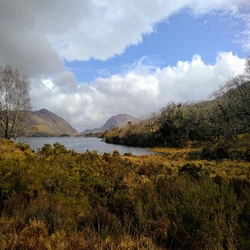
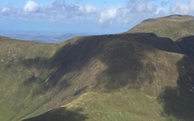
The Irish Coast To Coast Walk
Price
£12.00

Day 3 - Knockree to Laragh
Start: Knockree Youth Hostel (grid ref 192151)
Finish: Laragh (grid ref 143966)
Distance: 28km (17 miles)
Cumulative Distance: 59km (36.5 miles)
Maps: OSI Discovery 56, Harvey Maps’ Wicklow Mountains
Terrain: Riverside and forest tracks give way to paths across open moorland slopes. More forest tracks are followed by road walking and easy hill paths.
Refreshments: Roundwood is off-route and has a few pubs and restaurants. Laragh has a few more pubs and restaurants.
Today’s walk includes some of the best mountain scenery along the Wicklow Way, along with an option to climb to the summit of Djouce if you aspire to higher things. However, it is also a long day’s walk, bearing in mind the ascents and descents along the way, and some walkers would be happy to move off-route to Roundwood and cover the distance over two days at a more leisurely pace. The Wicklow Way used to be routed through the village of Laragh, but now by-passes it by a short distance. The village has a full range of facilities and no doubt many walkers continue to visit the place in search of accommodation, food and drink.
If you start the day from Knockree Youth Hostel you can short-cut by simply crossing the road, crossing a stile and walking down into the valley to join the Wicklow Way. To stick faithfully to the route, however, leave the hostel and turn right along the road, then head down to the left as signposted for the Wicklow Way. Walk down a narrow forest track from a barrier, and take the second turning on the left as marked. Walk along a narrow path and cross a stile before dropping down to the Glencree River. Turn left to follow it downstream, passing pools used for swimming and grassy patches used as unofficial campsites. A footbridge is reached on a bend in the river.
Cross over the footbridge and keep right to follow a path and forest track up to a road. Turn left along the road to Crone House, bearing in mind that nearby Coolakay House offers food and accommodation in the valley. Turn right up through a car park as signposted for the Wicklow Way and Glendalough. Follow a track uphill from the far end of the car park and turn left at a junction. Keep climbing along the track as marked, and it eventually levels out above Bahana. A couple of zig-zag bends take the track up to a splendid viewpoint around 300m (985ft) at Ride Rock. Powerscourt Waterfall plunges into a deep, forested glen, with the rounded shape of Djouce rising beyond. The Great Sugar Loaf is also in view.
PowerscourtKeep to the track to leave Ride Rock, rising across a steep slope of heather, bracken and bilberry. It becomes a narrow path across a more wooded slope, passing an outcrop of schist before heading into denser forest. Watch carefully for the marked path, as well as for boulders and exposed tree roots. When the path reaches the edge of the forest at 380m (1250ft), turn left and walk down to a footbridge spanning the River Dargle at the Watergates. This is another popular unofficial campsite.
The 18th-century mansion of Powerscourt House and its beautiful ornamental gardens are well off the course of the Wicklow Way. Powerscourt Deerpark, however, can be viewed from the lofty stance of the Ride Rock. The main attraction is Powerscourt Waterfall, which slides vigorously down slabs of granite and presents a powerful spectacle after heavy rain. The surrounding woodlands were planted on bare ground a century ago, and while the deer park is now defunct, descendents of its former inhabitants may still be seen in the locality. Red deer and sika deer have interbred so that red/sika hybrids might give rise to confusion when first spotted.
Walk straight uphill alongside the forest on a steep slope of grass, bracken and heather. At the top of the slope, cross a stile over a wall on the right and head along a path flanked by heather and bilberry, towards the rounded mountain of Djouce. Keep to the clearest path, then consider whether to branch right and make a summit bid, or keep straight on across the upper slopes of the mountain. The Wicklow Way traverses the slope and climbs to a moorland gap at 620m (2035ft), while the summit of Djouce rises to 725m (2385ft). If you climb the mountain, swing left at the summit rocks and trig point to follow a path straight back down towards the Wicklow Way.
Whatever route is chosen, the Wicklow Way crosses boggy ground by following a line of stout railway sleepers. Follow these over White Hill at 630m (2075ft), where cotton grass grows, and pass a white outcrop of quartz. The route leads downhill to pass through a gap between two stands of forest, crossing a chunky stile. Another length of railway sleeper path leads round to Luggala, where there are increasingly wonderful views of a deep glen and rolling mountain-moorlands. The Vartry Reservoir and the coast of Co Wicklow are also in view. Take a look at a small memorial stone tucked underneath a granite boulder: ‘To the memory of J B Malone – Pioneer of the Wicklow Way’. JB was also known as the ‘Walking Encyclopedia’.
Look down into the glen to see Lough Tay and a small part of Lough Dan. Walk down wooden steps and turn left at a junction to enter a forest. Turn right and right again to leave the forest, walking through a car park to reach the R759 road. Keep left to walk up the road, then down the road, still with good views into the glen. After passing the Pier Gates the road swings left down towards Roundwood, but the Wicklow Way turns right down a forest track at Sleamaine, passing a barrier. Keep straight on uphill at a junction, then keep right at another junction. Pass a hut on the way to a heathery gap in the forest. The track climbs across an open slope at Ballinafunshoge with views of Roundwood and the Vartry Reservoirs. Go through a gate back into the forest, almost to 440m (1445ft), and later drop downhill. A marker points to the right, indicating a boggy path crossing stones and tree roots. This later drops and there is a view of Lough Dan ahead. Turn left along a track, then right, then watch for a marked path leading down to a crossroads at Baltynanima. If you wish to move off-route to Roundwood, do it at this crossroads, otherwise turn right along the road.Wicklow Mountains National Park
The Wicklow Mountains National Park has been created in piecemeal fashion from various properties owned by the State. In effect, the national park is almost entirely State-owned and controlled, and largely covers all the bleak, barren, boggy mountains and moorlands through the heart of the Wicklow Mountains. In its full extent, the national park stretches from Kippure, the highest point in Co Dublin at 757m (2475ft) to Lugnaquillia, the highest point in Co Wicklow at 925m (3039ft). There was once a plan to build a visitor centre near Luggala, but this proved so controversial that the site had to be abandoned even though the initial groundwork had been completed.
RoundwoodFollow the road downhill from Baltynanima, through lovely oakwoods mixed with holly, honeysuckle and bilberry. Cross the Old Bridge over the Avonmore River and turn left at a road junction to climb uphill as signposted for Laragh and Glendalough. The steep and winding road passes the Wicklow Way Lodge and there is a shelter belt of fine trees alongside, to the left, including pines, chestnut and beech. Follow the road over a crest and downhill, then uphill again with the shelter belt still running alongside. Turn right at Pinewood Cottage and follow a track uphill, passing a house and going through a gate. Continue up the track to reach another gate, the Brusher Gate, and turn left. Cross a couple of stiles and walk alongside a forest, then walk through it for a while, then alongside it again. Cross a stile and follow a clear, grassy path across a slope of bracken, grass and heather. Keep right to walk alongside another forest, heading up to 350m (1150ft) on Paddock Hill. Walk downhill with views towards the village of Laragh and glorious Glendalough, surrounded by bleak and rugged mountains.
Roundwood is a long and straggly village that claims to be the highest in Ireland, standing around 230m (755ft). The huge Vartry Reservoirs near the village supply water to distant Dublin. Roundwood offers a small number of accommodation options, including a campsite. There is a post office, a couple of shops, a few pubs and restaurants, as well as toilets. St Kevin’s Bus (tel 01-2828119) operates a daily service through the village, linking with Dublin, Bray, Laragh and Glendalough.
The path drifts away from the forest and crosses a stile on its way downhill. Walk down a slope alongside a young forest, then head down to a track which leads through pleasantly mixed woodlands in Glenmacnass. When the R115 road is reached, turn left for a short way, then turn right down a path to reach a footbridge over the bouldery Glenmacnass River. The Wicklow Way turns right to continue, but if you wish to visit Laragh turn left to reach a track, then left again to head for the village and all its facilities.
Laragh
Although recently by-passed by the Wicklow Way, most wayfarers would head into Laragh to avail themselves of its services, and it has a reputation as the gateway to Glendalough. There is plenty of accommodation of all types, but in the height of summer every bed can be taken. There is a post office, a couple of shops, and a few pubs and restaurants. St Kevin’s Bus (tel 01-2828119) operates a daily service through the village, linking with Glendalough, Roundwood, Bray and Dublin. Laragh and Glendalough are among the busiest tourist destinations in Ireland, and in the summer months it makes sense to book your accommodation well in advance.


