


Article


English-language guidebook to the Karnischer Höhenweg, a 170km waymarked hut-to-hut trek along the border between Italy and Austria. Also known as the Carnic Peace Trail, it runs west to east along the ridge of the Carnic Alps, the site of the WW1 front line. With information on planning your trip, accommodation and the history of the area.
A guidebook to trekking the Karnischer Höhenweg, or Carnic Peace Trail. The 170km hut-to-hut trail follows the World War I front line through the Carnic Alps, along the border of Austria and Italy, and is rich in historical, geological and cultural interest. It can be hiked in 1–2 weeks and is suitable for walkers with a reasonable level of fitness, a sense of adventure and a head for heights.
The guidebook covers both the Austrian variant, which is presented in 8 day stages, and the Italian variant, presented over 10 days, with stages ranging from 6 to 28km. Also included are optional detours to climb neighbouring peaks, such as Monte Coglians.
John Hayes is a retired management consultant with degrees from Liverpool University and University College London. Immediately after finishing work in 2011 he embarked on an epic 5,000km trek across Europe, walking from Tarifa in Spain to Budapest. John has written for numerous walking and trekking magazines, and has written four walking guides and a cycling guide for Cicerone.
View author profile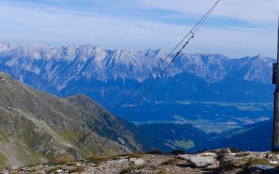


