

Take a county the size of Derbyshire, split it into nine uneven chunks and scatter them between Land's End and Northumberland, and you have roughly the extent of the Azores, about a third of the way from Europe to Canada. This planning guide helps you choose islands, seasons and transport for walking there. Paddy Dillon's guidebook describes 70 day walks of 3.5 to 27.5km (2 to 17 miles) across all nine islands. (Last updated: October 2026 · Guidebook edition: 1st edition, November 2019, reprinted July 2025)
Quick facts
- Location: Azores, Portugal: nine islands in three groups (Eastern, Central and Western), in the mid-Atlantic
- Total routes: 70 day walks, including 16 stages of the GR1 long-distance trail [Note: editorial count from the contents list]
- Distance range: 3.5km to 27.5km (2 to 17 miles); the longest figure is the extended version of Walk 20
- Typical duration: 1hr 30mins to 8hrs 30mins per walk
- Difficulty: mostly easy or moderate, with a few difficult, rugged or strenuous walks
- Terrain: volcanic craters and lake-filled calderas, geothermal areas, waterfalls, forest trails, old mule paths and rugged coast
- Highest point: Pico, Portugal's highest mountain, 2351m (7713ft)
- Navigation: most walks follow waymarked and signposted PR and GR trails; 1:50,000 mapping for each walk and downloadable GPX files
- Best season: year-round; high summer can be uncomfortably humid, winter is wetter with lower humidity
- Guidebook: Walking on the Azores by Paddy Dillon, 1st edition, November 2019, reprinted July 2025
What is Walking on the Azores?
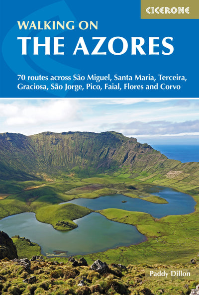
Walking on the Azores is Cicerone's guidebook to 70 routes across São Miguel, Santa Maria, Terceira, Graciosa, São Jorge, Pico, Faial, Flores and Corvo. It is written by Paddy Dillon and, as he puts it, the Azores appear as tiny dots on a globe, if they appear at all. The islands sit on a complex geological zone close to the junction of three tectonic plates, and the walks reflect that: perfect volcanic cones, lake-filled craters, geothermal areas, lava tubes, waterfalls and rugged coastlines.
Anyone who knows Madeira or the Canaries will find the Azores startlingly green. The islands are warm and temperate with little seasonal temperature difference, and the vegetation is sustained by regular rain that seldom lasts long. The author's advice is not to let that put you off: the moment the sun shines, the colours are intense. The walks run from short village-to-village strolls to remote mountain days, and most use the official waymarked trail network.
The islands were not settled until the 15th century, and many areas have since been transformed into pasture for dairy cattle. The cedars, hydrangeas and ginger lilies that look native are all introductions.
This planning guide answers the most common questions walkers have before setting out. For complete route descriptions and mapping, see the Cicerone Walking on the Azores guidebook.
Which Azores island is best for walking?
The guidebook's answer is that there is no single best island, because each offers something different to its neighbours. The better question is which combination suits your trip. The routes are grouped by island, and the islands fall into three groups: Eastern (São Miguel and Santa Maria), Central (Terceira, Graciosa, São Jorge, Pico and Faial) and Western (Flores and Corvo).
| Island | Walks | Routes | What to expect |
|---|---|---|---|
| São Miguel | 1 to 16 | 16 | The largest island, with the best transport links. Sete Cidades caldeira, Lagoa do Fogo, geothermal areas and waterfalls |
| Santa Maria | 17 to 22 | 6 | Reckoned to be the oldest island. Four GR1 stages (Walks 17 to 20) plus two day walks |
| Terceira | 23 to 29 | 7 | Seven day walks, from Monte Brasil at Angra do Heroísmo to Gruta do Natal and Porto Judeu |
| Graciosa | 30 to 33 | 4 | Three GR1 stages and a walk to the caldeira and Furna do Enxofre |
| São Jorge | 34 to 40 | 7 | Three GR1 stages, plus walks to coastal fajãs and Farol dos Rosais |
| Pico | 41 to 53 | 13 | The most walks of any island, ending with the ascent of Pico |
| Faial | 54 to 61 | 8 | Three GR1 stages from Capelinhos, plus Horta, Monte da Guia and the Caldeira do Faial |
| Flores | 62 to 67 | 6 | Three GR1 stages, plus walks to Fajã Grande and Água Quente |
| Corvo | 68 to 70 | 3 | The smallest island, with a classic walk to the lakes in the Caldeirão |
São Miguel is the usual starting point because most flights land at Ponta Delgada and it has the most frequent public transport. The author notes that the existing waymarked trails there would take a keen walker more than two weeks to complete. Corvo needs only a couple of good walking days before everything starts repeating itself, but the short walks are well worth the effort in good weather.

How long are the walks in the Azores?
The 70 walks range from 3.5km (2 miles) to 27.5km (17 miles), taking 1hr 30mins to 8hrs 30mins. Most are comfortable half-day or full-day outings. A handful of GR1 stages and one mountain ascent make up the longest days.
These eight walks from the guidebook's route summary show the range:
| Walk | Start-Finish | Distance | Ascent/descent | Time |
|---|---|---|---|---|
| Walk 2 Sete Cidades and Lagoa Verde (São Miguel) | Sete Cidades | 10km | 350m/350m | 3hrs 30mins |
| Walk 6 Lagoa do Fogo from Água de Alto (São Miguel) | Água de Alto | 15.5km | 650m/650m | 5hrs |
| Walk 25 Gruta do Natal and Mistérios Negros (Terceira) | Gruta do Natal | 5.5km | 170m/170m | 2hrs 30mins |
| Walk 40 Farol dos Rosais and Pico da Velha (São Jorge) | Ponta, Rosais | 12km | 330m/330m | 4hrs |
| Walk 53 Ascent of Pico (Pico) | Casa da Montanha | 6.5km | 1150m/1150m | 7hrs |
| Walk 57 Horta and Monte da Guia (Faial) | Marina, Horta | 3.5km | 200m/200m | 1hr 30mins |
| Walk 61 Caldeira do Faial (Faial) | Miradouro da Caldeira | 7km | 260m/260m | 2hrs 30mins |
| Walk 68 Lagoa do Caldeirão (Corvo) | Miradouro do Caldeirão | 5km | 200m/200m | 2hrs |
Is walking in the Azores difficult?
Most routes are easy or moderate, with a few graded difficult, so the book suits both beginners and experienced walkers. The author's own assessment is that none of the trails or mountains is any more difficult than anything you might meet in Britain on a sunny, rainy or misty day.
- Who it suits: walkers who are comfortable with a full day on foot, and anyone who wants short coastal strolls or village-to-village routes.
- The demanding days: the ascent of Pico (Walk 53), the longest GR1 stages and some steep mountain routes.
- Vegetation and ground: trails are often cleared, but off-trail vegetation is frequently impenetrable and slopes can be loose and crumbling. In places cattle leave deep hoof-holes. Stay on well-trodden paths rather than cutting across country.
- Equipment: no special equipment is needed beyond waterproofs, although an ice axe and crampons might be needed in winter on Pico. Carry enough food and water for each walk, with extra water on humid summer days.
What are the highlights of walking in the Azores?
By island the walks differ, but by experience the guidebook's highlights fall into a few groups.
- Crater lakes: the huge caldeira at Sete Cidades with its two lakes (Walks 1 and 2), Lagoa do Fogo (Walk 6) and the lakes in Corvo's Caldeirão (Walk 68).
- Geothermal areas: hot springs and bubbling mud pots in the central uplands of São Miguel, with waterfalls and viewpoints close by (Walk 7).
- Portugal's highest mountain: the ascent of Pico (Walk 53).
- Recent volcanic landscapes: the Capelinhos volcano on Faial, which erupted in 1957 and 1958, is the start of Walk 54.
- Underground exploration: lava tubes open to the public and chambers deep inside volcanic craters.
- Long-distance trails: GR1 stages on Santa Maria, Graciosa, São Jorge, Faial and Flores, each a linear route of several days.
How are the hiking trails waymarked in the Azores?
The Azores has an official trail network, and the bulk of the guidebook's routes are based on it. The waymarking system is the same on all nine islands, so you quickly learn to recognise it.
- PR and PRC trails are short routes, circular or linear, completed in a half day or full day. They are marked with red and yellow paint flashes, marker posts and signposts.
- GR trails are longer and usually linear, running for three or four days on half of the islands. They are marked with red and white paint flashes, marker posts and signposts.
- Where both run together, the markers merge into red, yellow and white.
Each trail has a name made up of its type, a number and a three-letter island code, such as GR1 SMA for the long-distance trail on Santa Maria. The guidebook gives the trail numbers wherever a specific trail is followed. Waymarked trails are generally open all year, but they can close for breeding birds, sporting events or damage, so check before you travel on the official Azores trails website, searching by island and then by trail number.

What map do I need for hiking in the Azores?
The guidebook includes 1:50,000 mapping for each walk, and GPX files for the routes can be downloaded from the Cicerone website. Maps of the quality of Ordnance Survey Landranger and Explorer sheets are not available in the Azores. The Portuguese military 1:25,000 maps are described as grossly out of date and 35 sheets are needed to cover the archipelago. The author points instead to the 1:50,000 Kompass map, which comes as a two-sheet, double-sided pack and is also offered in some mobile apps. Order maps well in advance from British suppliers.
When is the best time to walk in the Azores?
The Azores offer year-round walking, but the weather is changeable and varies from day to day, so plan around the season.
- Summer: generally plenty of sunny days and occasional showers, but the humidity can make walking uncomfortable.
- Winter: wetter, with more chance of low cloud on the mountains, but there are still outstanding sunny days and the lower humidity makes walking very pleasant.
- Pico in winter: the summit of Pico can catch snow, even if it falls nowhere else in the archipelago.
- Ferries: services to all nine islands run only from May to September, which matters if you plan to island-hop by sea.
The weather cannot be predicted with certainty more than a few days ahead, and conditions can differ between sea level and the high mountains. The author's advice is to use clear, sunny days for the mountains and switch to lower trails in rain or low cloud. Severe storms and hurricanes are rare.
What accommodation is available for a walking holiday in the Azores?
Accommodation is abundant, but there are no large resorts of the kind found in the Canary Islands. The main tourism website lists hotels, guest houses, self-catering apartments, hostels and campsites, and booking websites are useful for finding places at short notice if you plan to move between islands. The smaller islands can run out of accommodation at busy times, so a little advance planning is recommended.
If you plan to use public transport, choosing self-catering accommodation close to where most bus services depart is useful rather than somewhere that ties you to fixed mealtimes. The guidebook lists suggested bases for each island:
- São Miguel: Ponta Delgada or Furnas
- Terceira: Angra do Heroísmo or Praia da Vitória
- São Jorge: Velas or Calheta
- Pico: Madalena or São Roque
- Santa Maria: Vila do Porto
- Graciosa: Santa Cruz
- Faial: Horta
- Flores: Fajã Grande
- Corvo: Vila do Corvo
How do I get to the Azores?
Most visitors fly to São Miguel. Flights reach the Azores from around Europe and North America, as well as from Madeira and the Canary Islands, and the island of São Miguel handles most of them, with Terceira and Horta handling a few. The local airline is SATA Azores Airlines, and the Portuguese national airline TAP Air Portugal also flies there.
It can be difficult to find a direct flight from many airports, so be prepared for a routing that includes a break at Lisbon or Porto. From the UK, direct flights to Ponta Delgada have been seasonal and limited, so check current schedules before you plan. If you plan to fly to one of the smaller islands, the author recommends arranging a flight from Lisbon or Porto with SATA Azores Airlines, because the price is considerably lower than organising it once you are in the Azores.

Can I island-hop on a walking holiday in the Azores?
Yes, by air or by sea, but plan the order of islands around the transport. All nine islands have airports, but not every airport serves every island, and travelling from one island to another can involve as many as three flights. Most islands have flights every day, but some of the smaller ones do not.
- Flights: inter-island flights are operated by SATA Azores Airlines.
- Ferries: Atlânticoline is the only operator serving all nine islands, and only from May to September, when sailings may still not run daily
- Faial, Pico and São Jorge: these three islands have daily ferries throughout the year, which is useful because there are no flights between them.
- Flores and Corvo: a small boat links them year-round, but it is irregular and services may be cancelled when the sea is rough.
How do I get around each island without a car?
Public transport varies enormously between islands, but the author managed to research nearly all the routes in the guidebook by public transport.
- Buses: São Miguel has three bus companies and many services from early until late. Most other islands have a single bus company, and some services run only out and back in a day, and not every day of the week. Get up-to-date timetables as early as you can.
- Taxis: available on all islands and remarkably cheap, especially on the smaller islands when walkers share the fare. Only a few islands have a central booking number.
- Car hire: easy on most islands on arrival at the airport, though it is worth booking ahead for a secure arrangement. Corvo has no car hire.
- Corvo: there are no buses, but a couple of minibus drivers will take visitors to the Caldeirão.
Each walk in the guidebook includes a transport note.
Plan your Azores walks with the Cicerone guidebook
The Cicerone guidebook Walking on the Azores by Paddy Dillon contains everything you need to plan and complete 70 walks across the archipelago, from São Miguel to Corvo.
- 70 day walks across all nine islands, covering the Eastern, Central and Western groups
- Step-by-step route descriptions with 1:50,000 mapping for each walk
- Distance, walking time, terrain notes and points of interest for every route
- Downloadable GPX files for the routes
- Practical information on planning, transport, facilities and travelling between the islands
- Background on the geology, landscape, history, wildlife and protected areas of the Azores
- A route summary table, language notes with a topographical glossary, and useful contacts
Available as a printed guidebook or digital eBook.
About Paddy Dillon, guidebook author
Paddy Dillon is a prolific walker and guidebook writer, with over 100 guidebooks to his name and contributions to 40 other titles. He has written for several outdoor magazines and other publications and has appeared on radio and television.
Paddy uses a tablet computer to write as he walks. His descriptions are therefore precise, having been written at the very point at which the reader uses them.
Paddy is an indefatigable long-distance walker who has walked all of Britain's National Trails and several European trails. He has also walked in Nepal, China, Korea and the Rocky Mountains of Canada and the US.


