Trekking the Tour du Mont Blanc backwards

OK, Cicerone’s Jonathan Williams didn’t really walk the Tour du Mont Blanc backwards, he just went the 'wrong' way round...
Traditionally, when walking the Tour du Mont Blanc (TMB) you start from Les Houches and head south west and anti-clockwise before turning and heading north east through Italy. This is the route taken by thousands of trekkers every year as they take in one of the world’s great walks, around the monarch of the alps.
But why this way round? Trekkers have always gone both ways, but the clockwise route seems to be often neglected.
Is this justified? Should you swim against the tide? Is it better, worse or just different? What about the views, the accommodation? Why can’t we be different?
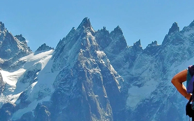
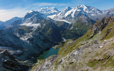
The route is written into the consciousness of the trekkers throughout the world – over the first col to Les Contamines, the big climb to the Col de la Croix du Bonhomme, Chapieux to Les Mottets then over the Col de la Seigne into Italy. Then three days walk under the hugely impressive south faces of Monte Bianco and the Grandes Jorasses, the Grand Col Ferret into Switzerland and delightful Champex, the choice of the Bovine or Fenêtre cols, the Col de la Balme and the Grand Balcon Nord before the long drop to Les Houches and a satisfying beer and celebratory meal.
Cicerone’s TMB guidebook has described both ways round since 2005 when, after a series of trekkers asked for the 'wrong way', we decided to put both in the book.
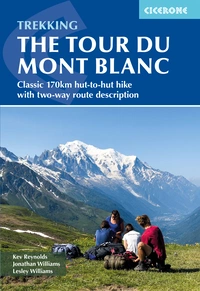
Trekking the Tour du Mont Blanc
Classic 170km hut-to-hut hike with two-way route description
£17.95
Guidebook for hiking the Tour du Mont Blanc, one of the world's classic treks. The 170km (105 mile) TMB route via France, Italy and Switzerland typically takes 11 days, and can be walked in anti-clockwise and clockwise directions. With trek planning resources, accommodation guide and 5, 7 and 9-day options. A 1:25,000 IGN map booklet is available separately.
More information
Top tips for a clockwise Tour of Mont Blanc
- Don’t start at Les Houches. Champex is a good point, Argentière at the other end of the Chamonix valley from Les Houches is another.
- Courmayeur makes a possible start and finish point for trekkers either accessed from Italy, or through the Mont Blanc tunnel from Chamonix.
- You can give yourself an easy start from Courmayeur by taking the cable car up to Col Chécrouit, or walking up the Val Veny on the lower variant towards Rifugio Elisabetta.
- Book accommodation well in advance through the autourdumontblanc website. Most places are listed. Book other (usually private) accommodation by phone or email.
- If you are a single walker or perhaps a couple there is a chance of booking day by day in the shoulder seasons, but it is still best to plan well ahead.
- Be fit enough before you start, it makes for a better trek experience.
- The Tour du Mont Blanc trail is open mid-June through past mid-September. Mid-July and August are the busiest periods. September tends to be a bit quieter, and the weather may be more settled.
Saying bonjour to the TMB trekkers and runners
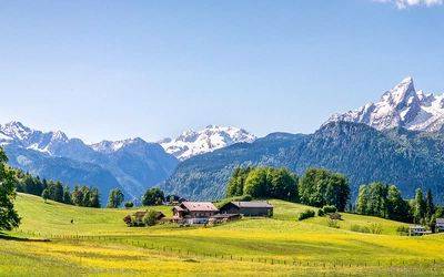
Clockwise, the traditional start point is Champex reached by train and bus from Martigny. Clearly a circular loop can be joined at any point, but if coming from anywhere north, Champex makes sense as an access point. This small resort is set around a charming lake under a backdrop of big peaks, The Pointe d’Orny just above, the Grand Combin in the distance.
I was fighting fit after several weeks of walking and writing in Switzerland (for the Zermatt and Saas-Fee guide by Jonathan and Lesley Williams). In truth, I was probably past my peak fitness with hundreds, likely thousands of kilometres and tens of thousands of metres of up and down in the previous couple of months.
On the day I started, the UTMB race was passing through. As I set off, the Spanish runner and eventual winner Pau Capell was heading through Champex, some 20 minutes ahead of his nearest rival. He had been running for 14 hours by then and looked fresh as a daisy as the cameraman (on a bike) tried to keep up with him. UTMB runners were a big feature of the day, and by the end I must have passed a couple of hundred.
Down the steep woods I had only ever climbed up before, and then the long pastoral walk up the valley, cross to the left bank of the river and through woods, under the Anemone slab, through friendly La Fouly and the short stretch to the hamlet of Ferret. All the time greeting runners, checking times and distances, taking photos in the crystal-clear air of the day.
But I had my instructions too, check this, check that. All part of a guidebook publisher’s life. The next day was to take the variant section to the farm at La Peule, high above the normal track. Then the long, steady climb to the Grand Col Ferret and meeting the first walkers of the day climbing from the Italian side. A group of young Israelis, carrying tents and big packs. Well done them.
It was cold on the col, and steep down the Italian side. There was something wrong with my leg, on the outside of the knee. Probably I had rushed around too much exploring above Ferret the previous evening, or sat awkwardly on it to write. Likely helped by cumulative ups and downs in the previous weeks. It hurt like hell. No solution but to walk it off. And analgesics.
Trekking down to Val Ferret and climbing up to incredible views opposite the Grandes Jorasses
The drop to Val Ferret is eroded in places and steep, perhaps one of the harder downhills. Then Elena, the magnificent rifugio at the foot of the col. But I was too early for lunch, so onwards. Down to the valley and then the climb to Rifugio Bonatti, directly facing the Grandes Jorasses: a great rifugio in a magnificent setting. It was full, but seemed to comfortably fit everyone in.
Next day along the main route to Courmayeur, with coffee at the Bertone rifugio after a couple of hours, then the long steep descent on a good path through woods in to Courmayeur. The leg was doing a bit better, the ibuprofen and paracetamol were making a difference. A good explore around Courmayeur is worthwhile. The main street is pedestrianised, and there are plentiful cafes, restaurants and outdoor shops. Then the nasty bit. My instructions were to take the route around the north side of Mont Chétif, most of which is along a road. A steep road, passing the entrance to the Mont Blanc tunnel, then facing the Brenva and Peuterey side of Monte Bianco, and then up to Rifugio Monte Bianco.
Big differences between clockwise and anti-clockwise – good to know
- You pass the anti-clockwise walkers mainly in a bunch in the middle of the day, perhaps within an hour or so. The rest of the time you get the mountains mostly to yourself, or at least with many fewer TMB walkers.
- You get to meet different trekkers every night, unless you fall in with other clockwise trekkers. There is less chance to get to know fellow trekkers over the days, but more variety for sure.
- Unless you stay at Bellachat, the climb to Brévent is nearly 1700m. Not everyone’s cup of tea all in one go, so staying at Bellachat (with the one water tap) is recommended. The views there can only be described as fantastic (not that I saw them this trip). If you start from Les Houches, this would be Day One. You can see why trekkers starting there usually go the other way.
- Courmayeur comes too soon for a rest day if you start from Champex, but Chamonix comes after 6–8 days walking
- Your head gets to turn right a fair bit, the normal anti-clockwise way it gets to turn left a lot. Much of a muchness really.
- Travel to Martigny and Champex is all on Swiss rail, while probably the simplest way to get to Les Houches is to take one of the minibus transports from Geneva, although trains are possible via St Gervais.
- On balance and by the tiniest whisker the views might be slightly better the normal anti-clockwise route. But I can’t be sure. I will have to check them both again!
Above the Val Veny alongside the ridges of Mont Blanc
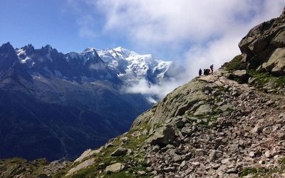
Off early the next morning, was it only day four? A steep climb through woods to the wonderfully sited Maison Vieille Rifugio and the long walk above the Val Veny with my face continually turned towards the searing ridges, glaciers and gullies of Mont Blanc. A drop down then a short climb to Elisabetta for lunch. An excellentetarte myrtille, then over the Col de la Seigne and into France and the Refuge des Mottets, a redeveloped dairy farm, with ample facilities, plenty of space, good company and good food.
My next day was silly. My own fault aa the refuges were seemingly full, plus a desire to spend the following night at the Bellachat refuge facing Mont Blanc’s north face meant I gave myself a 32km day with who knows how much up and down (I do, I measured it). Down to Chapieux, up the Croix du Bonhomme, down to Les Contamines, down the valley and up to the hamlet of Bionnassay. This was two normal stages! I arrived at the Auberge at 6:45 and found I had booked it twice but after a long discussion we came to a solution that seemed to satisfy us all. Dinner was a sweet, sweet meal.
Next day started murky and got worse. Over the Col de Voza, down to Les Houches to restock with analgesics. Then I started the long climb to Bellachat. It was OK past the giant statue of Christ the king and the zoo but then the storm started. It wasn’t thundering just then, so I made my way through the cabled section and onwards and upwards in the rain to the refuge, which was full of very wet people. Facilities are as limited as the view is vast – one tap and the whole of Mont Blanc. Needless to say, I saw absolutely nothing through the cloud on this occasion. So much for planning.
Onwards the next day and over the Brévent, still with no view, with the tricky bit involving ladders down to the Col du Brévent, down to Planpraz and across on the balcony route to Flegère. My instructions were to go up to Lac Blanc but the trail was closed. Plan B was to head to the Col des Montets, past the beautiful Cheserys lakes. Still no view. The drop to the col was hard going, the succession of long days taking a toll but the trek was nearly over. From the col it's down past the splendid Auberge la Boërne at Tré-le-Champ and across to the Montroc railway station and the slow train back to Martigny. My trip was done.
The plan had always been to stop at Tré-le-Champ. Lesley and I had walked the Tré-le-Champ and Argentière to Trient , and Trient to Champex sections the previous year while checking out the Chamonix to Zermatt route.