An introduction to Hadrian's Wall Path
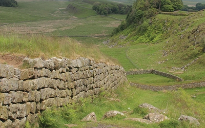
The Hadrian's Wall Path National Trail officially opened in 2003, stretching a total of 84 miles (135km). It follows Hadrian's Wall, which was built by Emperor Hadrian Aelius, who had the startling idea to build a wall from coast to coast. And so, the wall defined the province of Britannia and was the focus of life for those living around it for over 300 years. In 1987, the site was designated a UNESCO World Heritage Site and has become increasingly popular among long-distance thru-hikers and day walkers. If you're considering taking on this much-loved and historic trail, here is everything you need to know to plan your route: accommodation, distance, its history and how the Cicerone guidebook can help you along the way.
The history of Hadrian's Wall
The creation of Hadrian's Wall was the idea of Emperor Hadrian Aelius, who came to power in 117AD. After failing to claim Scotland, Rome established a frontier road between the Tyne and the Solway Firth, linking important defensive forts between Carlisle and Corbridge. Then came the idea to build the wall from coast to coast. The wall became a statement of authority, and was the Emperor's way of expressing his delight for architecture. Rather than the wall being seen as a barrier, it defined the northern edge of the province of the Britannia but not the extent of Roman influence.
Over the centuries, the requirement for farmland led to the destruction of pieces of the wall and today only a portion still remains visible - mostly in the central sector, which was restored in the mid-19th century or consolidated between the 1930s and the 1980s.
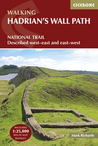
Hadrian's Wall Path
National Trail: Described west-east and east-west
£17.95
SALE
£15.26
Hadrians Wall Path guidebook to walk the 135km (84 mile) National Trail. Described in both directions, the main description is west to east between Bowness-on-Solway and Wallsend, Newcastle, with an extension to South Shields. With extensive historical information related to this World Heritage site and separate 1:25,000 OS map booklet included.
More information
How long is the Hadrian's Wall Path?
The Roman Wall stretches 135km (84 miles) west to east from the Solway Firth at Bowness-on-Solway to the mouth of the Tyne at Wallsend. For those wishing to complete the extension to South Shields to create a complete coast-to-coast route, an additional 11km (7 miles) of walking is required. Walkers interested in maritime history may also wish to extend the route to Maryport in Cumbria, utilising the Cumbria Coast Path.
How many days does it take to walk?
Optional itineraries include five-, seven-, and ten-day options, depending on your intentions along the route. Those wishing to take in the history of the Wall and walk at a more leisurely pace may opt for the ten-day route, whereas those who don't mind pushing on to complete the trail in as few as five days can cover between 23 and 34 km per day. Most commonly, walkers opt for a seven-day traverse.
How do you reach the start point?
The route begins at Bowness-on-Solway. The easiest way to travel is via Carlisle, which has a train station connecting to major cities across the UK, including Birmingham, London, Glasgow and more. From here, a bus or taxi is required to get to Bowness-on-Solway.
Which direction should you walk?
Scholars determined that the wall was originally built from east to west, and so they established a numbering system for the milecastles and turrets that matched this direction. Most walkers then opted to walk towards the west. However, if you decide to walk the trail from west to east, the prevailing weather will be at your back, and the sun will be over your shoulder, leading to optimal photography. Our guidebook describes the trail from both directions.
When is the best time of year to walk Hadrian's Wall Path?
Mindful of your boots' impact on this vulnerable piece of history, and for the best weather, it is recommended not to stray outside of the core walking season of April to the end of October.
What about accommodation on the route?
As the trail becomes more popular, more accommodations are becoming available; however, due to the high volume of hikers hitting the trail, advance booking in peak season is strongly advised. Some walkers opt to camp or use camping-barn facilities, which are common alongside private hotels. Other alternatives include bed and breakfasts (B&Bs) and guesthouses.
What are the stages of Hadrian's Wall Path?
| Stage | Start/Finish | Time | Distance |
|---|---|---|---|
| 1 | Bowness-on-Solway to Burgh-by-Sands | 4½ hr | 7½ miles (12km) |
| 2 | Burgh-by-Sands to Carlisle | 3½ hr | 7 miles (11km) |
| 3 | Carlisle to Newton | 5 hr | 9½ miles (15km) |
| 4 | Newton to Birdoswald | 4¾ hr | 8¼ miles (13km) |
| 5 | Birdoswald to Steel Rigg | 6 hr | 9½ miles (15km) |
| 6 | Steel Rigg to Brocolitia | 5 hr | 8 miles (13km) |
| 7 | Brocolitia to Portgate | 5¾ hr | 9½ miles (15km) |
| 8 | Portgate to Heddon-on-the-Wall | 6 hr | 10 miles (16km) |
| 9 | Heddon-on-the-Wall to Newcastle | 6 hr | 10 miles (16km) |
| 10 | Newcastle to Wallsend (Segedunum) | 2½ hr | 5 miles (8km) |
Hadrian's Wall Path
National Trail: Described west-east and east-west
£17.95
SALE
£15.26
Hadrians Wall Path guidebook to walk the 135km (84 mile) National Trail. Described in both directions, the main description is west to east between Bowness-on-Solway and Wallsend, Newcastle, with an extension to South Shields. With extensive historical information related to this World Heritage site and separate 1:25,000 OS map booklet included.
More information