History, wildlife and easy miles: a guide to walking England's North West Coast Path
The King Charles III England Coast Path (KCIIIECP) is the longest managed coastal trail in the world — but why walk the north-west section? Stretching from Gretna to Chester, the north-west section of the KCIIIECP offers a quieter take on coastal walking. Highlights include Roman sites in the north, the shipbuilding heritage of Barrow, and wide views across to the Lake District fells. The route passes through varied habitats — from sand dunes and saltmarsh to tidal mudflats — and with a strong focus on accessibility, it's a welcoming choice for walkers of all levels. Here’s everything you need to know.
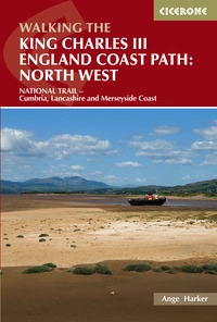
Walking the King Charles III England Coast Path: North West
NATIONAL TRAIL - Cumbria, Lancashire and Merseyside Coast
£17.95
Guidebook to walking the King Charles III England Coast Path: North West National Trail. Between Gretna and Chester, this 590km (367 mile) route explores the Cumbria, Lancashire and Merseyside coast in 27 stages and can be walked in 1 month. Includes 1:50,000 OS mapping.
More informationWhere does the north-west section of the KCIIIECP go?
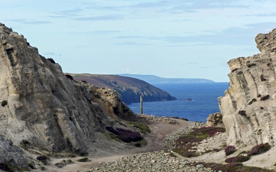
The north-west stretch covers 590km (367 miles) from Gretna, on the Scottish border, to Chester, on the cusp of Wales. It takes in the wild Solway Firth, the open Cumbrian coast, Morecambe Bay, the Ribble Estuary, Liverpool and the Wirral Peninsula — before connecting seamlessly to the Wales Coast Path.
Is it a challenging route?
Generally speaking, no — and that’s part of its appeal. With relatively few steep climbs and a terrain shaped more by glacial plains, sandy beaches and estuarine marshes than by rocky headlands, this is a gentler National Trail. However, that doesn’t mean it lacks variety, interest or challenge: long days and dune walking can still test stamina, and fit walkers can enjoy racking up big mileages.
Why walk this route if the Lake District is nearby?
The Lake District may offer the drama, but the coast delivers the breadth. This trail offers uninterrupted sea views, wildlife-rich landscapes, and coastal heritage without the crowds. It’s also significantly more accessible for many walkers — both in terms of terrain and public transport.
What makes this part of the coast special?
The sheer range of landscapes:
- Saltmarshes teeming with wintering geese
- Red sandstone cliffs at St Bees Head
- Vast sandy estuaries like Morecambe Bay and the Ribble
- Historic seaside towns and cultural cities
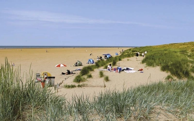
- Rolling dunes at Sefton and the Wirral
It’s also a haven for birdlife and coastal species — from natterjack toads to grey seals, with internationally important Sites of Special Scientific Interest (SSSIs) throughout.
Who is this route best suited to?
This section is ideal for:
- Day walkers and less experienced hikers looking for moderate terrain
- Nature lovers and birdwatchers
- Long-distance walkers wanting quieter, less strenuous miles
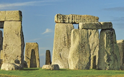
- Heritage enthusiasts, with Roman ruins, abbeys, castles and working ports
- Urban explorers keen to combine walking with Liverpool’s cultural hotspots
How long does it take to walk the north-west section?
That depends on your pace, goals and available time — and the good news is, this route has flexibility built in.
The guidebook outlines three main itineraries:
- 20 days averaging 29.4km (18.3 miles) per day — suited to experienced walkers comfortable with long daily distances.
- 28 days averaging 21km (13 miles) per day — a balanced option for those seeking steady progress with time to explore.
- 32 days averaging 18.4km (11.4 miles) per day — ideal for a gentler pace or for building in rest days, detours and sightseeing.
All options include some longer and shorter days depending on accommodation, terrain and access — but thanks to the region’s public transport, you can also adapt each stage to your needs. Whether you’re walking in one go or dipping in and out over months or years, there’s a way to make the north-west coast fit your journey.
What about accessibility and transport?
This is one of the best-served long-distance trails for public transport. Trains run close to the trail at regular intervals, particularly from Maryport to Heysham, Fleetwood to Lytham, and Southport to Neston. Local buses, while patchy in rural stretches, do exist — and in some cases, taxis offer a back-up option. You can easily tackle the route in bite-sized sections.
When’s the best time to walk it?
Spring and summer are popular for the long daylight hours, wildflowers and wildlife. However, autumn offers peace and solitude, and even winter has its charms — just be aware of tidal conditions and transport schedules. Many of the habitats and species on this route change beautifully with the seasons.
Is the route waymarked and safe?
Yes. Look for the familiar National Trail acorn symbol. The trail is continuously updated and rerouted if necessary through the "rollback" system, ensuring long-term continuity even as the coast changes. Safety is mostly common sense, but do check tide times, especially in areas like Morecambe Bay or the Solway marshes where hazards are not always visible.
What kind of accommodation is available?
There’s a good mix of B&Bs, hotels, and self-catering accommodation, especially in towns like Whitehaven, Barrow, Lancaster, Blackpool and Liverpool. Camping is possible, though cheap backpacker options are limited for now. The increasing popularity of the trail is likely to bring more facilities in future.
What should I bring?
In addition to the usual walking essentials, bring:
- Layers for wind and rain
- Sun protection
- Tide timetables and OS Explorer maps (1:25,000 scale is best)
- A power bank, especially if relying on a phone for mapping
- Cash, as rural ATMs can be scarce
Can I do just a section?
Absolutely. This trail is designed with flexibility in mind. Whether you have a weekend or a few weeks, the route adapts to you. Consider starting or finishing in a transport hub like Carlisle, Barrow or Liverpool for easy logistics.
Is there more to this route than walking?
Much more. This trail is a journey through the UK’s coastal history, biodiversity and identity. Roman forts, medieval abbeys, industrial harbours, seaside resorts and modern art installations all appear en route — not to mention the evolving conservation projects that make this coastline such a special place.
What’s the takeaway?
Don’t overlook the north-west. This section of the KCIIIECP is about space, light, nature and heritage — often in quiet contrast to the more rugged or crowded national trails. It’s a place where sea meets sky, where stories stretch for millennia, and where walking is made wonderfully possible for more of us than ever before.
A guidebook built for the King Charles III England Coast Path
To support walkers exploring this remarkable trail, we’ve created the first and most comprehensive guidebook to the north-west section of the King Charles III England Coast Path — a definitive resource built on more than a decade of first-hand research and insight.
To make navigation simple, the guidebook features step-by-step directions alongside clear 1:50,000 OS maps. Each stage includes practical details on refreshment stops, transport options and accommodation, with planning tools like route summaries and a trek planner to help you build your ideal itinerary. For those who want even more precision on the ground, optional companion booklets with full 1:25,000 OS mapping and route lines are also available.
This is the only guide to present the full trail in its current form — complete with bespoke link routes where access is pending — allowing you to walk the entire north-west coast path without waiting for official rollouts. With OS map updates taking up to six months and no full print alternative available elsewhere, it remains the most accurate and detailed resource for the trail.
More than just a walking guide, this book also unpacks the wider story of the coast path — from new access rights and legislation to the natural and cultural heritage that defines this stretch of coastline. Whether you’re a seasoned walker or a first-time explorer, it’s everything you need to discover a quieter, more accessible National Trail — and your essential companion for walking part of the longest managed coastal footpath in the world.


Want to explore more of the England Coast Path?
The King Charles III England Coast Path is being opened in sections across the country. To check which areas are currently accessible, visit the official National Trails website.
We also publish a number of guidebooks that cover coastal walking routes along or near the ECP — perfect if you’d like to continue your journey. These routes often follow the same coastline and share the spirit of the England Coast Path — with detailed mapping, expert insight and inspiring walks to suit all experience levels.