Cycling the Route des Grandes Alpes – what you need to know
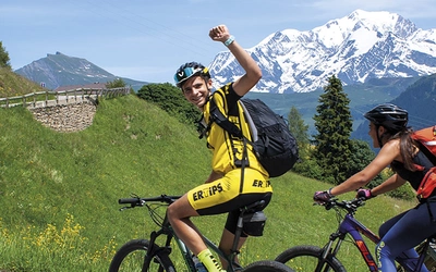
Discover the awesome passes of the French Alps on this stunning 720km journey from Lac Léman to cosmopolitan Nice. Breathtaking views open up around every turn in the road as the ride traverses pleasant pastures, verdant valleys and dramatic peaks. Here's everything you need to know about the route.
Essential facts:
What? The awesome passes of the French Alps (RdGA)
Where? France
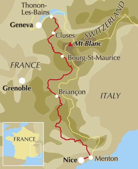
Start point? Thonon-les-Bains on the southern shores of Lac Léman
End point? Menton/Nice
Distance? 720km
Completion time? 1-2 weeks
Why this route? Tackle famous 'Tour de France' climbs
How hard is the route?
The route is challenging and only for well-prepared cyclists with experience of undertaking medium-distance rides on mountain roads. eBike technology makes the route more accessible but good fitness levels remain necessary. This is not a route for novices.
How many stages?
For the purposes of our guidebook the main route has been split into 14 stages. Experienced and conditioned cyclists, those used to riding in the mountains and prepared to spend much of the day in the saddle tackling at least 2 major climbs in a single day, should be able to complete the route in 7–10 days. However, the real joy of this route comes with the ability to stop, look and listen, to truly engage with the spectacular surroundings and enjoy all the Alps has to offer. If time allows, the 14-day schedule, punctuated with a couple of rest days in towns of interest, allows for a more immersive experience. For those with tight schedules and strong legs, alternative itinerary options are presented in ’Alternative schedules’ at the beginning of the guidebook.
What time of year?
Late-spring to early-summer or late-summer to early-Autumn are the best times to ride the route when the high passes have been cleared of snow while avoiding the heat of mid-summer.
How to reach the start and end points?
The start town of the RdGA, Thonon-les-Bains, lies some 35km north-west of the well-connected city of Geneva (Genève in French), with a number of transport options available into the city. Like Geneva, the RdGA finish point of Nice is very well connected. Its main railway station Nice-Ville has 11 departures a day direct into Paris Gare de Lyon. Meanwhile, the city’s international airport serves 108 destinations (21 in France and 87 international, including 69 in Europe). For return bus travel see the international bus companies previously referenced.
What kind of bike do you need?
The most important thing in selecting a bike for the route is to ensure that you feel comfortable riding for prolonged periods. Due to the length of the route and the demanding terrain, the following types of bikes are worthy of consideration (note: a mountain bike, designed primarily for off-road use, is not recommended).
- Road bikes: For seasoned road cyclists used to extended periods of time in the riding position that road racing bikes demand, and who are not carrying a heavy load, road racing bikes are an option, particularly if splitting the route into relatively short stages. Light and agile, built for speed and aerodynamics, they are well suited for riding the long and generally well-surfaced climbs that feature on the route.
- Touring bikes: Designed for long-distance rides, road touring bikes are heavier than road racing bikes but are sturdier, handle well and are better equipped to carry load. Tyres on a tourer tend to be wider and thicker than on a road bike and while this creates more rolling resistance, it does reduce the potential for punctures and offers better traction when descending.
- Gravel bikes: Similar in appearance to road bikes, a gravel bike offers a yet more robust option and is generally considered the most versatile machine available today. While offering much in the way of road bike efficiency, they have a more forgiving geometry and have more heavily treaded tyres offering more grip.
- eBikes: With demand booming and charging infrastructure increasingly available, an eBike variant of the bikes listed above is now a viable option for tackling the RdGA. The benefit of battery-assisted pedalling on long and steep climbs is obvious; however, there are a number of things to consider when deciding whether an eBike is the correct choice for your trip.
What accommodation is available?
There are plentiful hotels, hostels, auberges, refuges, chambre d’hôtes (B&Bs) and campsites on or close to the route. Expect to pay upwards from around €45/night for a hotel room or B&B, €20/night for a dorm bed in a hostel and from €10/night for camping. Pre-erected tents and cabins on campsites are widespread and often available out of high season, providing a good option for a comfortable night while keeping costs down and minimising the amount of equipment you need to carry. It is always a good idea to book accommodation at least a day or two ahead, not least to ensure you have a destination secured before you set out for your day’s ride, reducing any late-day stress trying to find a spot for the night after a long day in the saddle. More notice is advisable during during late July and August and if the Tour de France is in the area at the time of your visit be aware that hotels and campsites can be booked up months in advance.
What about food and drink?
As one might expect from a route that traverses the high mountains of France, the regional food offered throughout the RdGA is often hearty fare reflective of the surroundings. In the northern Alps local specialities celebrate the cheeses produced there, including tartiflette – a combination of reblochon cheese, potatoes and lardons – as well as raclette and fondue. Other local delicacies include perch and cured meats. Further south you can find oreilles d’âne (donkey’s ears), which is actually a gratin made of spinach and either pasta sheets or pancakes, and once you enter the Alpes-Maritimes, nearer the sea, you will find offerings such as salade niçoise and la socca, a pancake made with chickpea flour.
What's the connection with the Tour de France?
First held in 1903 by the sports daily L’Auto, the Tour de France quickly became cycling’s most prestigious race. In 1910, organizers added the Pyrenees to the route, forcing riders to push their bikes up steep, unpaved roads, much to the readers' delight. The experiment's success led to the inclusion of the high Alps the following year.
Now, over 100 years later, the Alps are a cornerstone of the Tour, with key stages held in these mountains where many historic moments have unfolded. Notable events include Louison Bobet's 1953 attack on the Col de Vars, leading to his first of three Tour wins, and Jeannie Longo's 1989 triumph on the Izoard, securing her third consecutive title in the women's race.
All climbs featured on the Route des Grandes Alpes have been part of the Tour de France, allowing tourists to follow in the pedal strokes of legendary cyclists.
Major climbs on the Route des Grandes Alpes
| Climb | Altitude | Length | Average gradient |
|---|---|---|---|
| Col des Gets | 1170m | 7.7km | 3.6% |
| Col de la Colombière | 1613m | 18.6km | 6% |
| Col des Aravis | 1486m | 10.1km | 5% |
| Col des Saisies | 1650m | 15km | 4.8% |
| Le Cormet de Roselend | 1967m | 23km | 6% |
| Col de l’Iseran | 2764m | 47.2km | 4.2% |
| Col du Télégraphe | 1566m | 11.9km | 7.2% |
| Col du Galibier | 2642m | 18.2km | 6.8% |
| Col d’Izoard | 2360m | 20km | 5.7% |
| Col de Vars | 2108m | 19km | 6.5% |
| Col de la Cayolle | 2326m | 29.1km | 4% |
| Col de Valberg | 1672m | 12.2km | 6% |
| Col de la Couillole | 1678m | 7.2km | 3.2% |
| Col Saint Martin | 1500m | 16.2km | 6.4% |
| Col de Turini | 1604m | 15.2km | 7.2% |
| Col de Castillon | 706m | 7km | 5.1% |
| Col d’Èze | 507m | 17.7km | 3.1% |
And finally, a personal account of the route...
Jonathan and I tackled our biggest cycling challenge yet: 650km and 15,000m of climbing over 9 days through the French Alps, creating a reversed question mark shape on our route. Starting in the second week of June, we faced uncertainty due to several key passes being closed from the heavy snowfall of the 2017/2018 winter.
Setting off with minimal gear, each carrying a 30-litre pannier bag and essential tools, we began our journey from Thonon-les-Bains. Our first day took us over the Col de Cou to la Clusaz, bypassing the closed Col de la Colombière.
On the second day, after the Col des Aravis and Col des Saisies, we paused for the Dauphiné race before tackling the Cormet de Roselend. The climb was challenging, but we were rewarded with stunning alpine landscapes and a descent to Bourg St Maurice.
Facing closed passes like the Col de l’Iseran and Col du Galibier, we rerouted over the Col de la Madeleine. After a tough climb, we enjoyed a thrilling descent to La Chambre, where we learned that the Galibier had just opened. The next day, despite rain and a minor accident, we climbed the Col du Télégraphe and Galibier, experiencing breathtaking views and challenging conditions.
From Briançon, we ascended the scenic Col d'Izoard, and after a bike repair in Embrun, we continued over the less enjoyable Col de Vars to Barcelonnette. The highlight was the climb up the Col de la Bonette, the highest paved road in Europe, where we joined cyclists from various countries.
Descending into the southern Alps, we mistakenly stayed in Auron, 400m higher than planned. We then climbed the Col de St Martin, passing through a town hosting an ultra-trail event. Our final day took us over the Col de Turini and Col de Castillon, finally revealing the Mediterranean below. The dangerous descent to Menton was nerve-wracking, but the sight of the promenade marked the triumphant end of our epic journey.
Lesley Williams
Cycling the Route des Grandes Alpes
Cycling through the French Alps from Lac Leman to Menton/Nice
£16.95
Guidebook to cycling the 720km Route des Grandes Alpes through south-eastern France. From Lake Geneva to Mediterranean Nice via numerous high Alpine passes, taking in the Vanoise, Écrins and Mercantour National Parks, the route is challenging, although entirely on roads. However, with plenty of charging points, it is well suited to eBikes.
More information