Walking the Shropshire Way
A two-week circular trail including the Wrekin, Stiperstones and Wenlock Edge
Walking the Shropshire Way
A two-week circular trail including the Wrekin, Stiperstones and Wenlock Edge
Guidebook describing a 2 week trail around Shropshire. The 182 mile (290km) route is made up of two loops centred on Shrewsbury and visits Stiperstones, Wenlock Edge, Ironbridge and the Wrekin. Also describes the challenging 20 mile (32km) Stretton Skyline Walk.A guidebook to walking the Shropshire Way. Covering 290km (182 miles), this long-distance circular trek exploring the area around Shrewsbury can be hiked in around 2 weeks and is suitable for all reasonably fit walkers.
The route is described in 15 stages, each between 18 and 24km (11–15 miles) in length, and comprises two loops that can each be walked separately in a week or combined to form a 2-week trek. The challenging 2-day Stretton Skyline Walk (32km, 20 miles) is also included.
- 1:50,000 OS maps included for each stage
- GPX files available to download
- Detailed information on facilities, public transport and accommodation on route
- Advice on planning and preparation
- Highlights include Stiperstones and Wenlock Edge
Printed book
A guidebook with detailed route descriptions, stage breakdowns, accommodation listings, profiles and maps - everything you need on the trail.
eBook
The complete digital edition of the guidebook, with full route descriptions, accommodation listings, profiles and maps, ready to use on any device.
Overview map
Overview profile
Map key
Foreword
Route summary table
Introduction
The Shropshire Way
Shropshire’s history
Shropshire’s geology (by Ronald Turnbull)
Wildlife and plants
When to go
Getting there
Getting around
Accommodation and planning
Safety
What to take
Using GPS
Waymarking
Using this guide
The Shropshire Way
Stage 1 Shrewsbury to Bridges
Stage 2 Bridges to Bishop’s Castle
Stage 3 Bishop’s Castle to Clun
Stage 4 Clun to Craven Arms
Stage 5 Craven Arms to Ludlow
Stage 6 Ludlow to Wheathill
Stage 7 Wheathill to Wilderhope Manor
Stage 8 Wilderhope to Ironbridge
Stage 9 Ironbridge to Wellington
Stage 10 Wellington to Haughmond
Stage 10A Haughmond to Shrewsbury link
Stage 11 Haughmond to Wem
Stage 12 Wem to Ellesmere and Whitchurch
Stage 13 Ellesmere to Llanymynech
Stage 14 Llanymynech to Nesscliffe
Stage 15 Nesscliffe to Shrewsbury
Stretton Skyline Walk
Appendix A Facilities table
Appendix B Accommodation
Appendix C Travel information
Appendix D Useful contacts
Seasons
The walk can be done in all seasons, but spring, summer and autumn are best as woodland paths can be slippery in winter. Regardless of the season, waterproofs are essential
Centres
Shrewsbury, Bishop's Castle, Clun, Craven Arms, Ludlow, Much Wenlock, Ironbridge, Wellington, Wem, Whitchurch, Ellesmere, Llanymynech, Nesscliffe
Difficulty
The well-marked Way is 182-200 miles, depending on the route chosen, and requires moderate fitness and a good pair of walking boots to cover approximately 12 miles each day. The hills are generally gentle and rolling, although Stiperstones has a rough quartzite ridge
Must See
Shrewsbury's ancient architecture; the Stiperstones; Offa's Dyke; Clun Castle; historic Ludlow; Brown Clee Hill (Shropshire's highest); Wenlock Edge; Ironbridge, birthplace of the Industrial Revolution; the Shropshire Union Canal; Haughmond Abbey; Grinshill sandstone quarry
March 2025
Stage 8
Pages 97 and 98 (map below)
In 2024 landslides below the Benthal Edge near Ironbridge made the old Shropshire Way route tricky and the Shropshire Way Association have devised a new route as follows:
Take the right fork path then turn right through a walkers’ gate next to a farm gate. This leads to a farm track, which should be followed along the field-edge.
Soon after passing the brick-built farmhouse and outbuildings of the Benthall Estate the track comes to Benthall Hall’s visitor car park. Turn left here and go through the smaller of two gates onto another track passing St Bartholomew’s Church, beyond which there are glimpses of the main hall.
Through another gate go straight on along a field-edge track which passes beneath rows of pylons before coming across more gates close to a junction of tracks. Take the track on the right. This comes to a road-end. Follow this down to the outskirts of Broseley, ignoring a right fork lane.
At the bottom of the lane turn left downhill towards Ironbridge. As you approach Ironbridge follow the pavement on the right side of the road as it veers slightly away and down towards some houses. Some steps at its end take you down to the old Iron Bridge in the centre of town.
February 2023
Diversion at Mountfields (p161)
Shrewsbury council says the Shropshire Way path in Mountfields is unstable and has prohibited its use between its junction with Mount Street to the steps at the bottom of Hunter Street. The Order expires in June 2023.
To avoid this turn right up Mount Street then left along Alma Street. Turn right down to the end of Hunter Street where you turn right along the continuing Shropshire Way (signed path).
December 2021
2022 Reprint route updates
July 2021
Temporary closures
IMPORTANT INFORMATION ABOUT A TEMPORARY CLOSURE ORDER FROM THE SHROPSHIRE WAY ASSOCIATION
The SW main route is closed from Monday 24th May for up to 6 months at the moment from the north end of Drinkwater Street (SJ48681308) in Frankwell to Doctor’s Field (SJ48421315) and vice versa, while the riverside footpath is closed for embankment stabilisation works.
There is a suggested description of the alternative route. It adds some 250 metres to the route.
From the top of the steps at the north end of Drinkwater Street (SJ48681308), follow this street south for 80 metres to Hermitage Walk. Turn right and follow this path for 170 metres until it becomes the pavement of The Mount. Continue along this for a further 160 metres until a narrow footpath between brick walls goes right. Descend this footpath for 120 metres until it joins the riverside footpath at SJ48421315.
At SJ48421315, at a noticeboard, a footpath leaves the riverside route to the right, crosses Doctor’s Field and climbs up to meet The Mount after 120 metres. Turn left along the pavement for 160 metres until a tarmac path (Hermitage Walk) bears left. Follow this path for a further 170 metres until it meets Drinkwater Street. Turn left and follow this street for 80 metres until you reach the top of some steps. Turn right here (SJ48681308) onto the narrow footpath which is the SWMR.
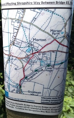
TEMPORARY CLOSURE OF MONTGOMERY CANAL TOWPATH BETWEEN REDWITH BRIDGE AND CRICKHEATH WHARF
The canal towpath used by SW main route is closed until 31 October 2021 between Pryce’s Bridge and Crickheath Bridge and for canal restoration works. This will necessitate a diversion NW along the road from Redwith Bridge SJ 301 241 then a cross-field path SW to the B4396, followed by another field path in the grounds of Tankard Hall. A lane then leads back to Crickheath Bridge where the towpath continues to Llanymynech. (see diagram)
April 2021
Route west of Brown Clee Hill
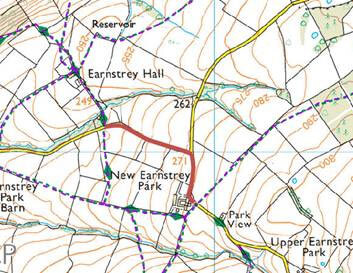
The Shropshire Way Association has made a change to the Shropshire Way due to constant poor ground conditions over some land.
The route change is between SO 57527 88108 and SO 57923 87771 around New Earnstrey Park in Abdon and Tugford Parish, Shropshire, so the new route will follow the County Road rather than cut across the fields. New route is shown in red on the map.
On P87 of the guidebook it should now read:
Turn left along the lane, passing New Earnstrey Park Farm before turning left at the next junction. Follow the stony, grass-islanded track to Earnstrey Hall.
November 2020
Correction
Altitude chart pages 6 and 7
The first summit should be labelled Wilderley Hill. Stiperstones should point to the next summit at 530m and 18 miles.
August 2020
Teashop closed
Page 63 The guide says that the route turns after passing the Tea on the Way teashop. Unfortunately, this has now permanently closed therefore there will be nothing for a walker to use as a marker to make a left turn.
Free Royal Mail 48 postage on UK orders. European postage is £3.50 per item. Worldwide postage is £5.50 per item. If you're not happy with your purchase for any reason, we'll give you a full refund.
Learn morePopular related guides


