The Two Moors Way: a complete planning guide
The Two Moors Way is a 188km (117-mile) coast-to-coast walking route across Devon, running from Wembury Bay on the south coast to Lynmouth on the north coast. Also known as Devon's Coast to Coast, the route crosses two of southwest England's most magnificent moorlands — the granite heights of Dartmoor and the softer, sandstone landscape of Exmoor — while passing through the quiet countryside of the South Hams and Mid Devon in between. (Last updated: April 2026 · Guidebook edition: 3rd edition, June 2026)
Two Moors Way quick facts:
- Distance: 188km / 117 miles
- Duration: 10–14 days
- Start: Wembury Bay, South Devon
- Finish: Lynmouth, North Devon
- Stages: 11 (plus low-level alternatives for 2 stages)
- Difficulty: Moderate, with some challenging moorland sections
- Terrain: Coastal paths, moorland, rolling countryside, woodland and riverside paths
- Waymark: Two Moors Way symbol (patchy on moorland sections; map and compass essential)
- Best season: April to October
- Also available: Two Moors Way Trail Map, 1:25,000 OS route mapping
- Guidebook: The Two Moors Way by Sue Viccars, 3rd edition
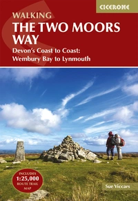
The Two Moors Way
Devon's Coast to Coast: Wembury Bay to Lynmouth
£18.95
Guidebook to walking Devon's Coast to Coast, a 188km (117-mile) route incorporating the Two Moors Way and a section of the Erme-Plym Trail. Beginning at Wembury Bay on the south coast and finishing at Lynmouth, the walk passes through the beautiful countryside of Dartmoor and Exmoor. A map booklet of the full route on OS 1:25K maps is included.
More information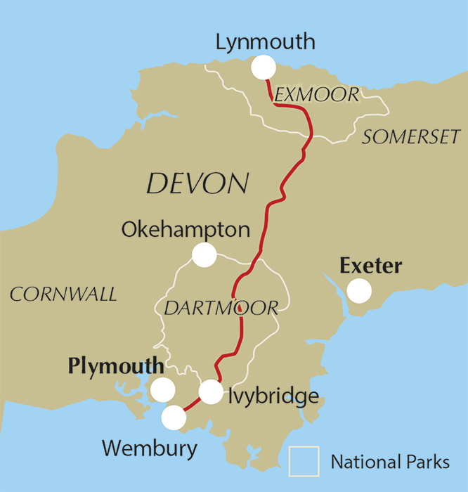
What is the Two Moors Way?
The Two Moors Way is Devon's coast-to-coast walk: a 188km route that crosses the entire breadth of southern England's largest county, from the South Devon coast to the towering sea cliffs and wooded valleys of North Devon. It is the only county in England where a genuine coast-to-coast walk is possible, with the south and north coasts markedly different in character, and the contrast between the landscapes encountered along the way is one of the route's greatest pleasures.
The route combines two distinct paths. The original Two Moors Way, created by Joe Turner and officially opened on 29 May 1976, links the two moors across Dartmoor National Park and the southern edge of Exmoor. In 2005 it was extended southward by linking it with a section of the Erme–Plym Trail, adding 26.5km (16.5 miles) from Wembury to Ivybridge and creating the full coast-to-coast route described in this guide.
The walk passes through four distinct landscape types, each with its own character and rewards: the rolling fields and copses of the South Hams; the granite moorland of Dartmoor with its Bronze Age archaeology, granite tors and wild ponies; the quiet farmland, ancient churches and remote hamlets of Mid Devon (the part of Devon most visitors never see); and finally the softer moorland of Exmoor, finishing with a dramatic descent above the wooded East Lyn valley to the sea at Lynmouth.
In 2026 the route celebrates the 50th anniversary of the original Two Moors Way with walking events at key locations along the route. See The Two Moors Way website for more information.
This planning guide answers the most common questions walkers have before setting out. For complete stage-by-stage route descriptions, OS mapping, transport details and accommodation information, see the Cicerone Two Moors Way guidebook.
How long is the Two Moors Way?
The Two Moors Way covers 188km (117 miles) across 11 stages from Wembury Bay to Lynmouth. The route does not divide into neat stages of equal length: Stage 6 (Chagford Bridge to Morchard Road) is the longest day at 28.9km (18 miles), while Stage 8 (Witheridge to Knowstone) is the shortest at 12.5km (7.8 miles).
| Stage | Distance | Time | Ascent |
|---|---|---|---|
| 1 - Wembury Beach to Yealmpton | 12km (7.5 miles) | 4hr | 355m |
| 2 - Yealmpton to Ivybridge | 14.5km (9 miles) | 4hr 30min | 280m |
| 3 - Ivybridge to Holne | 21.8km (13.5 miles) | 7hr | 595m |
| 3A - Ivybridge to Holne (low-level) | 26.8km (16.5 miles) | 7hr 30min | 535m |
| 4 - Holne to Dunstone Down | 11.5km (7.3 miles) | 4hr | 425m |
| 5 - Dunstone Down to Chagford Bridge | 16.8km (10.5 miles) | 5hr 30min | 425m |
| 5A - Dunstone Down to Chagford Bridge (low-level) | 17.5km (11 miles) | 6hr | 390m |
| 6 - Chagford Bridge to Morchard Road | 28.9km (18 miles) | 8hr | 655m |
| 7 - Morchard Road to Witheridge | 16.8km (10.5 miles) | 5hr 30min | 485m |
| 8 - Witheridge to Knowstone | 12.5km (7.8 miles) | 4hr | 210m |
| 9 - Knowstone to Tarr Steps | 17.5km (11 miles) | 5hr 15min | 475m |
| 10 - Tarr Steps to Simonsbath | 17.5km (11 miles) | 6hr | 415m |
| 11 - Simonsbath to Lynmouth | 17.5km (11 miles) | 6hr | 440m |
Note: Stage 3 (Ivybridge to Holne) at 21.8km across open Dartmoor is the most challenging stage for navigation and terrain. A low-level alternative (Stage 3A) is provided for poor weather or less confident navigators; it adds 5km but avoids the most exposed moorland. A similar low-level alternative (Stage 5A) is offered for the Hamel Down ridge section on Stage 5.
Who is the Two Moors Way suitable for?
The Two Moors Way is suitable for walkers of reasonable fitness. The terrain is undulating throughout rather than mountainous, and most stages are manageable by anyone with experience of rural walking in mixed conditions.
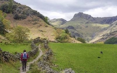
That said, there are two sections where the route makes genuine demands: Stage 3 across southern Dartmoor (Ivybridge to Holne) and the Chains section of Stage 11 on Exmoor. Both cross open moorland where waymarking is sparse or absent, the ground can be rough and boggy, and mist can close in rapidly. Map and compass skills are essential for these sections; walkers not confident in their navigation should use the low-level alternative route (Stage 3A variant described in the guidebook).
Walkers with dogs need to keep them on a lead during the lambing and bird-nesting season (1 March to 31 July) and under close control at all other times, as livestock will be encountered in fields and on the moorland commons throughout.
How difficult is the Two Moors Way?
The route is rated moderate, but this masks significant variation between stages. Stages 1 and 2 through the South Hams are gentle introductions; Stage 6 (28.9km with 655m of ascent) is a long and testing day; and Stages 3 and 11 on open moorland require map and compass competence in poor visibility.
Key challenges include:
Stage 3: 21.8km across southern Dartmoor with a pathless middle section. When mist is down, confident navigation is essential between the Red Lake track and leaving the moor at Chalk Ford. Low-level alternative available (Stage 3A)
Stage 6: the longest stage at 28.9km. It can be split by overnighting in Drewsteignton or breaking at the 17.8km mark near Newbury
Stage 11: crosses the Chains on Exmoor (487m, the watershed near the source of the River Exe) where map and compass are needed in poor visibility
Moorland conditions: paths and field gateways in the Mid Devon and South Hams sections can be wet and muddy after rain. Boots and gaiters are recommended except in very dry conditions
Walkers tackling the route in fewer stages to give longer days will find it more demanding than the standard itinerary suggests.
Which direction should I walk the Two Moors Way?
The guidebook describes the route south to north, from Wembury to Lynmouth, and this is the recommended direction for most walkers. Walking this way means:
- Stages 1 and 2 through the South Hams provide a gentle introduction before the Dartmoor crossing on Stage 3
- The prevailing southwesterly winds are broadly at your back
- Transport access to Wembury (near Plymouth) is better than to Lynmouth
- The route ends with some of the most spectacular scenery on the entire walk: the descent through the wooded East Lyn valley to Lynmouth is a wonderful finish
Walking north to south is possible and perfectly legal, but starts with a steep 250m climb from Lynmouth to the top of the East Lyn ravine. An abbreviated north-to-south route description is included at the end of each stage in the guidebook.
When is the best time to walk the Two Moors Way?
The route is walkable year-round in good conditions, but late spring and early summer (April to the end of June) and autumn (September and October) are generally the best times, avoiding the peak holiday season while enjoying the finest of Devon's seasonal landscapes.
- April to June: woods and hedgebanks thick with primroses, bluebells and wild garlic; pony foals and lambs on the moorland commons; skylark song on Dartmoor; green light in the East Lyn valley oakwoods
- August: rich purple heather on both moors, bright yellow gorse, long days
- September and October: beautiful autumn colours in the valley woodlands and Exmoor's famous beech hedgebanks; fewer people; generally drier conditions underfoot
- Winter: possible for experienced walkers, but Dartmoor and Exmoor are bleak in bad weather, accommodation is more limited, and some stretches become very muddy
Weather note: Devon is at the mercy of Atlantic depressions and receives significant rainfall, particularly on the moors. Dartmoor's annual rainfall at Princetown is roughly double that of Plymouth, just 15 miles away. Whatever the season, carry good waterproofs at all times.
Accommodation note: Easter and summer holidays bring a significant increase in demand, particularly at the start and finish and on the moorland stretches. Book well in advance if travelling in peak season. Some accommodation providers close between late October half-term and Easter.
What accommodation is available?
Overnight accommodation must be booked in advance along the Two Moors Way. The route passes through rural Devon, where options are limited and cannot be relied upon without prior booking.
The most popular approach is to stay at B&Bs, pubs and small hotels along or near the route. Many accommodation providers are accustomed to walkers and will offer pick-up and drop-off from the nearest point on the route, packed lunches and drying facilities. Details are in the guidebook appendix and on the Two Moors Way website, which maintains an up-to-date interactive 'Stay and Eat' map.
Other options include:
- Self-catering accommodation: book a base for a few days and tackle three or four stages from it, using a car or driver to shuttle between stage start and end
- Luggage transfer: companies such as Luggage Transfers will move bags between overnight stops for a fee
- Self-guided packages: Encounter Holidays and other operators offer organised trips with accommodation and luggage transfer arranged
Wild camping: Dartmoor is the only national park in England where wild camping (when backpacking) is permitted, subject to rules. Lightweight tents only; not within 100 metres of a road; not visible from the roadside or any property; not on enclosed farmland. Check dartmoor-npa.gov.uk for the downloadable camping map. Wild camping is not permitted anywhere on Exmoor.
What is the landscape like on the Two Moors Way?
The route passes through four distinct landscapes, each with its own geology, character and seasonal highlights.
The South Hams (Stages 1–2): The rolling fields, copses and hedgebanked lanes of South Devon provide a gentle introduction. The underlying Devonian slates, sandstones and limestones produce a characteristically green and sheltered landscape — the word 'hams' comes from the Old English for an enclosed or sheltered space. This is the most pastoral section of the walk.
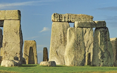
Dartmoor (Stages 3–5): The granite plateau rises to 621m at High Willhays in the northwest. In good conditions it is a landscape of extraordinary openness, scattered with Bronze Age hut circles, stone rows and tors sculpted by millennia of erosion. Dartmoor has the greatest concentration of Bronze Age sites in England, and medieval tin-working pits and gullies are still visible today. In mist or rain, the moor becomes austere and demanding; the low-level alternative (Stage 3A) is there for a reason.
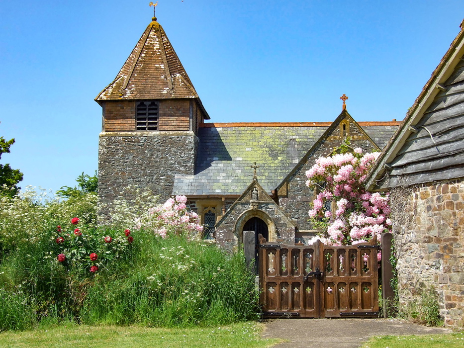
Mid Devon (Stages 6–8): The hilly, hedgebanked countryside between the two moors is the part of Devon most visitors never see. Carboniferous sandstones produce the characteristic red soils visible particularly on Stages 6 and 7. Ancient churches, remote farms and hamlets, a complex network of narrow lanes: this is rural Devon at its quietest and most authentic.
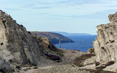
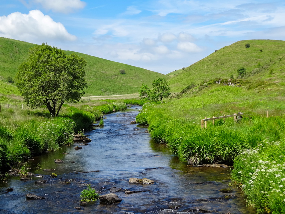
Exmoor (Stages 9–11): Compared with Dartmoor's harsh granite, Exmoor's folded sedimentary rocks produce smoother, more rounded slopes, dissected by picturesque rivers running through steep combes. The route runs alongside the lovely River Barle before crossing the watershed at the Chains (487m), near the source of the River Exe. The final stage drops through the dramatic wooded East Lyn valley to Lynmouth, beneath Exmoor's extraordinary hog's-back cliffs, the highest sea cliffs in England.
What wildlife might I see on the Two Moors Way?
The Two Moors Way passes through two national parks and some of Devon's least-visited countryside, and the wildlife encountered is correspondingly rich.
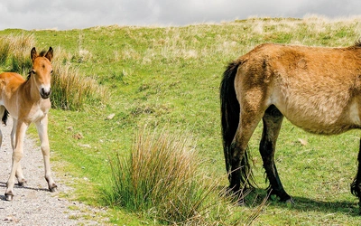
Dartmoor hill ponies are among the moor's most celebrated residents, and walkers are likely to encounter them on Hamel Down and around Bennett's Cross on Stage 5. Numbers have fallen from around 30,000 in the 1950s to approximately 1,000 today. Exmoor ponies remain more true to the original breed standard and are classified as an endangered species; around 3,500 survive worldwide. Some are found near Landacre Bridge above the River Barle on Stage 10. Both species should be admired from a distance and never fed.
Red deer are present in the greatest numbers in England on Exmoor, where around 3,000 animals are thought to live. The otter has been recorded on every river in Devon, though you would be very lucky to spot one; look for footprints and spraint on riverbanks.
Birdlife is rich throughout. Skylarks are prominent on both moors in spring and summer. Buzzards are a near-constant presence across the whole route. Dartmoor holds the last remaining breeding population of dunlin in southern England, and blanket bog restoration work on both moors is encouraging curlew to return.
The Devon hedgebanks, many over 800 years old, support an extraordinary range of wildflowers: primroses, bluebells and wild garlic in spring; heather and gorse on the moors in late summer; and Exmoor's famous beech hedgebanks turning bronze and orange in autumn.
What are the route highlights?
The Two Moors Way moves through dramatically varied landscapes across its 188km. Key highlights include:
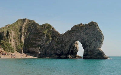
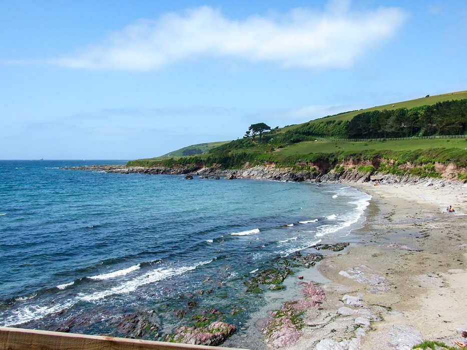
Wembury Bay (Stage 1): the dramatic South Devon coast provides a memorable start, with Wembury Marine Centre and the Great Mewstone offshore
The southern Dartmoor crossing (Stage 3): the route follows the Redlake Tramway trackbed across the high moor, one of the most atmospheric sections of the entire walk and genuinely remote in poor weather
Warren House Inn (Stages 4–5): the highest pub in southern England, a welcome landmark on the Dartmoor section
Chagford (near Stage 5): a beautiful stannary town just off the route, worth a short detour for its independent shops and excellent food
Teign Gorge and Castle Drogo (Stages 5–6): the Teign cuts through a spectacular wooded gorge; Castle Drogo, designed by Edwin Lutyens, is the youngest "castle" in England
Tarr Steps (Stages 9–10): the ancient clapper bridge across the River Barle on Exmoor, one of the most photographed structures in the southwest. A permanent bridle bridge nearby ensures the route is passable even when the clapper bridge is damaged by floodwater
Barle Valley and Simonsbath (Stage 10): the peaceful riverside walk to Simonsbath, at the heart of Exmoor's former Royal Forest, is one of the finest stretches on the route
The Chains (Stage 11): Exmoor's high watershed at 487m, near the source of the River Exe, crossing the boundary of the former Royal Forest
The East Lyn valley and Lynmouth (Stage 11): the dramatic wooded gorge descent provides a spectacular finish; Lynmouth, known as "England's Little Switzerland", sits beneath Exmoor's highest sea cliffs
How do I get to the start and back from the finish?
Getting to Wembury (start): Wembury can be reached from Plymouth, which is on the main Paddington to Penzance railway line (GWR). From Plymouth city centre, First Bus no. 48 runs to Wembury via Plymstock. Taxi services from Plymouth station include Taxi First (+44 1752 222222, taxifirst.net, around £20 to Wembury) and Wembury Cars (+44 1752 881651, around £22). From Ivybridge station, Ivy Cabs (+44 1752 895555) charge around £45 to Wembury. All prices 2025; verify before travelling.
Getting home from Lynmouth (finish): Lynmouth is not well served by public transport. Bus services 309/310 run to Barnstaple Monday to Saturday, connecting with the Tarka Line railway to Exeter. Full timetables are at travelinesw.com and visitlyntonandlynmouth.com. Taxi services include Lyn Valley Taxi (07907 161666, lynvalleytaxi.co.uk) and Riverside Taxis (01598 753442, riversidetaxis-lynton.co.uk), both of which can transport walkers to Taunton for main rail connections and collect from Wembury at the start.
Transport along the route: Public transport across rural Devon is generally poor. The route briefly encounters the rail network at Ivybridge (Stages 2–3) and Morchard Road (Stage 6–7), and crosses the Dartmoor Line at Stage 6. For most of the route, walkers tackling it in stages need their own transport, a support driver, or to stay at each stage end rather than returning to a base. Consult Traveline (travelinesw.com) for current timetables.
Plan your walk with the Cicerone guidebook
The Cicerone Two Moors Way guidebook, written by Sue Viccars and now in its third edition (June 2026), provides everything you need to walk the route with confidence:
- Detailed stage-by-stage route descriptions for all 11 stages
- Low-level alternative routes for Stages 3 (3A) and 5 (5A)
- Stage facilities planner showing accommodation, refreshment, toilets and transport at every stage
- 1:25,000 OS mapping in a separate pull-out booklet
- Abbreviated route description for those walking north to south
- Full accommodation appendix and details of luggage transfer and self-guided trip operators
- Transport information for all access points including bus routes and taxi contacts
- Geology, wildlife, history and seasonal notes throughout
- Downloadable GPX files at cicerone.co.uk/1317
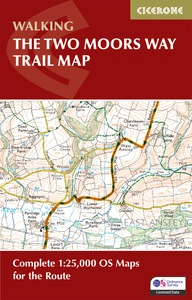
Available as a printed guidebook or digital eBook. A separate Two Moors Way Trail Map (1:25,000 OS route mapping) is also available.
The Two Moors Way Trail Map
Complete 1:25,000 OS Maps for the Route
£9.95
Map booklet for Devon's Coast to Coast, a 117 mile route incorporating the Two Moors Way and a section of the Erme-Plym Trail. This booklet is included with the Cicerone guide to the trail, and shows the full route on OS 1:25K maps. A perfect week-long holiday, the walk passes through the beautiful countryside of Dartmoor and Exmoor.
More informationAbout Sue Viccars, guidebook author:
As soon as she could after leaving Exeter University, Sue grabbed the chance to return to Devon, commissioning walking, equestrian and countryside books for David & Charles Publishers. She started writing her first walking book three weeks after going freelance in 2000 and since then has written or contributed to around twenty books (and edited dozens more), specialising in southwest England, especially Dartmoor and Exmoor. She writes the walks for Exmoor Magazine, and from 2008 to 2024 was editor and co-owner of Dartmoor Magazine. Sue is Information Officer for the Two Moors Way Association, and a committee member of the Outdoor Writers and Photographers Guild.
Further afield she has walked across Corsica; in Madeira, the Canaries and the Balearics; scrambled in Snowdonia and the Scottish Highlands; scaled the heights of Skye’s Cuillin and Morocco’s Atlas Mountains. She has also trekked to Everest Base Camp and in the Kangchenjunga region of Nepal. Recently she has embarked on a thorough exploration of the Scottish islands.