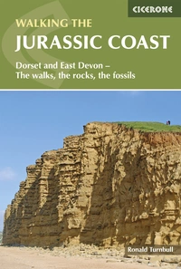
Walking the Jurassic Coast: a complete planning guide
The Jurassic Coast between Exmouth in East Devon and Poole Bay in Dorset is the only stretch of coastline in the UK to hold UNESCO Natural World Heritage status — sharing that distinction with the Giant's Causeway and St Kilda. The reason is written into the rock: the 160km of cliffs and beaches tell a 200-million-year story in stone, from the red Triassic sandstones of Devon through the Jurassic lias and oolite of Lyme Regis and West Bay to the Cretaceous chalk of the Isle of Purbeck. Ronald Turnbull's guidebook describes 30 walks across the five geological sections of this coastline, combining sweeping cliff-top paths, green inland ridgeways, and fossil-rich beaches, each route accompanied by accessible explanations of the geology underfoot. (Last updated: June 2026 · Guidebook edition: 1st edition, 2024)
Walking the Jurassic Coast, quick facts:
- Location: Dorset and East Devon, southern England
- Total routes: 30 walks (plus two full-day challenge routes)
- Distance range: 5km to 25.5km (3 to 16 miles) per walk; most routes have shorter variants
- Typical duration:2hrs to 7½hrs per walk
- Routes are not graded; difficulty information is given in each walk header
- Terrain: Cliff-top paths, grassy downland ridgeways, beach and foreshore, inland valleys and heathland
- UNESCO status: Jurassic Coast World Heritage Site (the only Natural World Heritage Site in the UK, shared with the Giant's Causeway and St Kilda)
- Navigation: Coast path is clear and waymarked; inland sections less so — OS Explorer maps recommended
- Best season: May, June, and September for quieter paths and comfortable walking; winter best for fossil finding; Lulworth Ranges open all week during school summer holidays only
- Main bases: Exmouth, Budleigh Salterton, Sidmouth, Lyme Regis, Bridport/West Bay, Weymouth, Swanage, Wareham
- Transport: Good rail links to Exeter, Axminster, Dorchester, Wool, and Wareham; Jurassic Coaster bus X53 connects coastal villages
- Guidebook:Walking the Jurassic Coast by Ronald Turnbull, 1st edition
Walking the Jurassic Coast
Dorset and East Devon: The walks, the rocks, the fossils
£14.95
This guidebook includes 30 walks on the Jurassic Coast of Devon and Dorset. Covering the coast between Exmouth and Bournemouth, these delightful routes range from 3 to 16 miles (5 to 24km), exploring and explaining the spectacular geology of this World Heritage area with clear, easily understood descriptions, cross-sections and timelines.
More information
What is Walking the Jurassic Coast?
Walking the Jurassic Coast by Ronald Turnbull is a day-walk collection covering the full length of England's only UNESCO Natural World Heritage coastline, from Exmouth in East Devon to the Isle of Purbeck in Dorset. The 30 routes are divided across five sections that follow the geological sequence of the coast — Devon's Red Beds, the Lias, Chesil Beach, the Chalk country around Lulworth, and the Isle of Purbeck — with each section introduction explaining why its particular rocks formed when they did.
What sets this guidebook apart from other Jurassic Coast walking guides is its integration of accessible geology. Each route includes notes on the rock formations underfoot, fossil finds to look for, and the extraordinary earth events — flash floods from vanished mountain ranges, soupy Cretaceous seas, the slow-motion collision of Italy with Europe — that shaped the landscape. Geological markers on the route maps indicate points of interest, while the appendices include a complete cliff diagram of the entire coastline and a geological timechart from the Cambrian to the present.
The walks themselves are excellent in their own right: sweeping cliff-top paths with views to Portland Bill and the Isle of Purbeck, quiet inland downland ridges, the fossil beaches of Lyme Regis, the extraordinary formations of Lulworth Cove, and the dramatic chalk stacks of Old Harry Rocks. For complete route descriptions and geology notes for all 30 walks, see the Cicerone Walking the Jurassic Coast guidebook.
The 30 walks at a glance
The guidebook divides the coast into five geological sections, each with its own character and rock story. Many routes have shorter variants, and the table below shows the full-length distances and times.
| Section | Walks | Distance range | Time range |
|---|---|---|---|
| 1 Devon's Red Beds (Exmouth to Seaton) | 1–11 | 6.5–21km | 2½hrs–6hrs |
| 2 The Lias (Seaton to West Bay) | 12–18 | 9.5–19km | 3hrs–6hrs |
| 3 Chesil Beach (West Bay to Osmington) | 19–23 | 13.5–21.5km | 4hrs–6hrs |
| 4 Chalk walks: Lulworth and inland | 24–29 | 6–25.5km | 2hrs–7½hrs |
| 5 Isle of Purbeck | 30–35 | 9.5–16km | 3hrs–4½hrs |
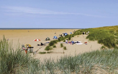
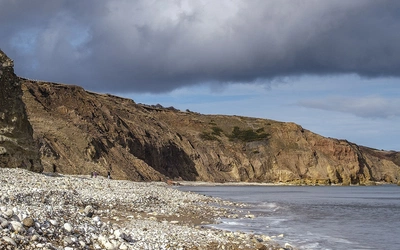
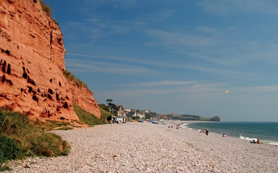
Section 1: Devon's Red Beds (Walks 1–11) covers the red Triassic sandstones of East Devon, from the pebble beds of Budleigh Salterton (waterworn quartzite pebbles washed by flash floods from a mountain range that existed where today we see only the sea) to the Beer Stone limestone headland and the start of the Great Unconformity at Salcombe Mouth. Seven coastal walks and two inland routes — including the Brixham and River Dart walk and the Dumpdon and Hartridge inland circuit.
Section 2: The Lias (Walks 12–18) is the ammonite chapter, centred on Lyme Regis — the fossil capital of England — and covering the great Undercliff landslip, the iconic clifftop of Golden Cap (191m, the highest point on England's south coast), and the working harbour at West Bay. This is the most geologically rich section: the shales and limestones of the Lias contain 71 distinct fossil zones at Lyme Regis alone.
Section 3: Chesil Beach (Walks 19–23) covers the extraordinary shingle barrier of Chesil Beach and the transition from Jurassic oolite limestone to Cretaceous chalk. The Isle of Portland circuit (Walk 22, 13.5km) explores the famous Portland Stone — the limestone used to build St Paul's Cathedral and much of central London. The South Dorset ridgeway walks here are some of the finest inland walking in the guidebook.
Section 4: Chalk walks — Lulworth and inland (Walks 24–29) covers the most geologically dramatic stretch of the coast: Lulworth Cove (where the chalk and limestone have been bent vertically by the slow-motion collision of Africa and Europe), the Fossil Forest on the coast east of Lulworth, Durdle Door, and the inland chalk downland of Hardy's Egdon Heath and Cerne Abbas. The most demanding walk in the book — Walk 21 on Woolland Hill (25.5km, 550m ascent, 7½hrs) — is in this area. Note that Walks 25 and 26 pass through the Lulworth Ranges, which are only open all week during school holiday periods; check before setting out.
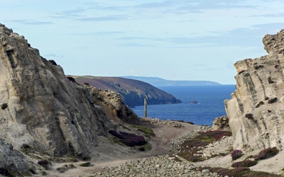
Section 5: Isle of Purbeck (Walks 30–35) covers the six routes of the final section: Kimmeridge Bay with its wave-cut ledges, the dramatic Chapman's Pool and St Alban's Head, Dancing Ledge, and the chalk headland of Ballard Down ending at the sea stacks of Old Harry Rocks. The Isle of Purbeck Circuit (Walk 34, approximately 27.5km and 8hrs) is one of two full-day challenge routes described in the book.

What makes the Jurassic Coast special for walkers?
The Jurassic Coast earned its UNESCO Natural World Heritage status not for one dramatic feature but for the complete 200-million-year geological sequence visible in its 160km of cliffs. Reading the coast from west to east is reading from older rocks to younger ones, from the Triassic red sandstones of Devon to the Jurassic lias and Portland Stone to the Cretaceous chalk of Purbeck.
For walkers, this means that each stretch of coastline looks and feels completely different from the last. The red cliffs of Budleigh Salterton share nothing with the grey-black shales of Lyme Regis or the brilliant white chalk of Ballard Down. The sea arches, stacks, coves, and wave-cut platforms along the way are not decorative accidents but the products of the same geological processes — wave action, cliff collapse, fault lines, the compression of continents — that shaped the rocks over millions of years.
The geology need not dominate a visit. The walks are designed to be enjoyed first and foremost as walks, and the geology notes and pictures are additional extras. Equally, for those who want to look more closely, this is a coast where the rock record is unusually legible: fossils wash out of the cliffs onto the beach, the Great Unconformity is visible at a single glance on several walks, and the bending of rock strata at Lulworth Cove can be read like a diagram in a textbook.
Fossil finding on the Jurassic Coast
The Jurassic Coast is the finest fossil-finding destination in Britain. Ammonites, belemnites, ancient oysters, worm burrows, and occasional reptile fragments wash out of the Lias cliffs onto the beaches below, particularly after winter storms and overnight high tides.
The best conditions for fossil finding are early morning after an overnight high tide, in autumn and winter, and away from busy beaches near car parks. No hammer is needed — over much of this coast, hammering is illegal — and the best equipment is simply eyes and feet: looking at clean, sea-washed boulders and freshly broken shale, and sifting through the shingle turned over by the latest tide.
Key fossil sites covered in the guidebook include Lyme Regis (the richest Lias site in Britain, where Mary Anning made many of her famous finds), Charmouth Beach, Dancing Ledge in Purbeck (ammonites the size of dinner plates embedded in the ledge), and the Fossil Forest east of Lulworth Cove (tree stumps and algal mounds from a forest that stood here 135 million years ago).
A full fossil code is summarised in the guidebook and available at jurassiccoast.org. Collecting loose specimens from the beach and foreshore is generally acceptable; using hammers or digging into cliffs is deprecated or banned over most of the coast. Important finds can be reported to the Charmouth Heritage Centre.
How difficult are the walks?
The walks in this guidebook are not graded, but each header includes distance, ascent, estimated time, and any specific considerations such as tides, the Lulworth Ranges, or difficult terrain. Walking times are calculated at a moderate pace (4km per hour plus 12 minutes per 100m of ascent) — if you spend time on the geology, add up to two hours to any walk.
The shorter variants of many routes — about half the 30 walks offer a cut-down option — are manageable half-day outings of 2–3 hours. The longest and most demanding routes, particularly Walk 21 (Woolland Hill, 25.5km, 7½hrs) and Walk 14 (Lyme Regis to Conegar Hill and Charmouth, 19km, 6hrs), are full days for fit and experienced walkers.
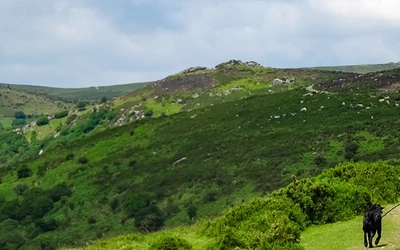
Most coastal walks involve a mix of sea-level path, cliff-top walking, and inland descent and ascent — the guidebook describes this pattern as 'sea-level to cliff top of the coastal afternoon.' The inland ridgeway walks are generally easier, with gentler gradients and less exposure.

Important safety and access considerations
Tides: Several walks descend to beach level and section walks use the foreshore. Always be aware of whether the tide is going in or out and the time of the next high tide. Tide tables for local harbours up to a year ahead are at visitmyharbour.com (times given in GMT; add 1 hour for British Summer Time).
Cliff falls: Cliff collapses are a regular occurrence on this coast. Never sit or shelter at the cliff foot; geologists approach only briefly and take lunch well out on the beach. If you come across a dangerous recent cliff fall, inform the Coastguard on 999.
Lulworth Ranges: Walks 25 and 26 pass through the MOD tank ranges east of Lulworth. These are open all week during school holiday periods and at weekends throughout the year. Check current access at gov.uk before setting out — the scenery is some of the finest on the Dorset coast and well worth the planning.
Landslips: The Lyme Regis Undercliff (Walk 12) passes through an area of active landslip. The path can be temporarily closed; check with local information centres or at southwestcoastpath.org.uk (search 'route changes').
When is the best time to walk the Jurassic Coast?
- May and June are the finest months: quieter than summer, comfortable temperatures, and good visibility for the long coastal views. The Lulworth Ranges are open at weekends.
- Late July to end of August (school summer holidays) is peak season. Beaches and villages are at their busiest, but the Lulworth Ranges are open throughout the week — the only time all walks are accessible without weekend timing.
- September is an excellent shoulder season: the sea is still warm, crowds thin quickly after the school term begins, and the light is good for photography.
- Winter (November to March) is the best time for fossil finding, particularly after storms, but brings mud underfoot, some accommodation closures, and the suspension of the baggage transfer service. Shorter daylight hours require earlier starts.
Getting to and around the Jurassic Coast
The West Country rail network gives good access to many walk start points. Key stations include Exeter (with a branch line to Exmouth), Honiton, Axminster, Dorchester (with a branch to Weymouth), Wool, and Wareham, plus Poole and Bournemouth at the eastern end. The 'Jurassic Coaster' bus X53 (Firstbus) links many of the coastal villages with each other and with Exeter and the main rail stations, making point-to-point coastal walks straightforward without a car.
For air travellers, local airports at Exeter and Bournemouth serve UK routes. Bristol has a wider range of overseas connections. London airports are convenient given the strong rail links into the area.
Detailed bus stop information for the Dorset coast is at dorsetcouncil.gov.uk; the public transport journey planner is at travelinesw.com.
What are the highlights of walking the Jurassic Coast?
- Lyme Regis and the Undercliff (Walks 12–14) is the geological heart of the coast. The great Bindon Landslip, the fossil beaches of Monmouth Beach and Charmouth, and the story of Mary Anning — the self-taught fossil hunter who discovered the first complete ichthyosaur skeleton — make this the most historically and geologically rich section.
- Golden Cap (Walks 15–16) at 191m is the highest point on England's south coast, rising as a sheer sandstone and greensand headland above Seatown. The view from the summit — eastward past Bridport and Chesil Beach to Portland, westward to Devon — is the finest on the Jurassic Coast.
- Lulworth Cove (Walk 29) is the most famous geological formation on the coast: a near-perfect circular cove carved when the sea broke through a narrow band of resistant limestone and cut into the softer chalk and clay behind. The surrounding coastline includes the Fossil Forest, the Durdle Door limestone arch, and Stair Hole — a cove in the process of being formed.
- Dancing Ledge (Walk 33) is a flat wave-cut platform of Portland Stone below the Purbeck cliffs, famous for the ammonites visible in the ledge itself and for the rock pool blasted out by a local school for bathing.
- Old Harry Rocks (Walk 35) are the chalk stacks at the tip of Ballard Down, the easternmost point of the Jurassic Coast, marking the end of the chalk ridge that continues — submerged — across to the Needles on the Isle of Wight.
- The Red Bed Roundabout is a full-day inland circuit of 33km (approximately 10 hours) through the East Devon hills, described as an extended route in Section 1 and visible on the overview map at the front of the guidebook.
Plan your walk with the Cicerone guidebook
The Cicerone Walking the Jurassic Coast guidebook by Ronald Turnbull contains everything you need to plan and complete all 30 walks across the Jurassic Coast.
- 30 walks covering the full length of the Jurassic Coast from Exmouth to the Isle of Purbeck, many with shorter variants
- Route summary table (Appendix A) listing all 30 walks by start/finish, distance, ascent, and time
- Geology notes integrated into every route description, with ammonite markers on route maps indicating geological points of interest
- Geological introduction covering the sea, the Great Unconformity, the Universal Formations, the fossils, and continental drift — written for walkers, not geologists
- Five section introductions explaining the geological sequence of each part of the coast
- Free GPX files available to download at cicerone.co.uk/741/GPX
- Appendices covering indoor geology museums and visitor centres, rock reference websites and books, a geological timechart, a rocks reference guide, and a complete coloured cliff diagram of the entire Jurassic Coast
- Fossil collecting guidance, tide safety, Lulworth Ranges access, and landslip information throughout
Available as a printed guidebook (£14.95) or digital eBook (£14.95).
Walking the Jurassic Coast
Dorset and East Devon: The walks, the rocks, the fossils
£14.95
This guidebook includes 30 walks on the Jurassic Coast of Devon and Dorset. Covering the coast between Exmouth and Bournemouth, these delightful routes range from 3 to 16 miles (5 to 24km), exploring and explaining the spectacular geology of this World Heritage area with clear, easily understood descriptions, cross-sections and timelines.
More informationAbout Ronald Turnbull, guidebook author
Ronald Turnbull was born in St Andrews, Scotland, into an energetic fellwalking family. In 1995 he won the Fell Running Association's Long-distance Trophy for a non-stop run over all the 2000ft hills of Southern Scotland. He has made 21 different coast-to-coast crossings of the UK, slept out on over 80 UK summits, and completed California's 220-mile John Muir Trail and East Lothian's 45-mile John Muir Way in a single season. His recent books include The Book of the Bivvy, walking guides to the Cairngorms and Ben Nevis and Glen Coe, and Three Peaks Ten Tors. He has nine times won Outdoor Writers and Photographers Guild Awards for Excellence, has a regular column in Lakeland Walker, and writes in Trail, Cumbria, and TGO. Ronald lives in the Lowther Hills of Dumfriesshire.