Ancient mysteries of Northumberland

There are few places in England where the distant past has such a tangible effect on the landscape as it does in Northumberland. Stepping out into the atmospheric border country inevitably means stepping back in time and brushing shoulders with our ancestors. Vivienne Crow, the author of our guidebook to the county, looks at some of the historic gems awaiting walkers…
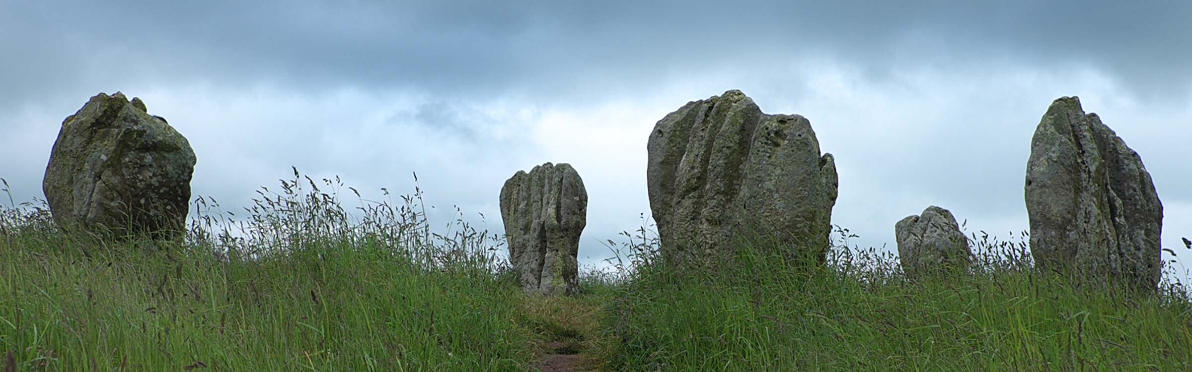
Like deformed fists punching up through the soil, the sandstone blocks of the Duddo Stone Circle stand proud on a small rise of land in north Northumberland. It’s a fairly flat area, given over to large fields of wheat and barley, so it comes as a big surprise to reach the stones and be greeted by far-reaching views in all directions. These rocks couldn’t have been placed here arbitrarily 4,200 years ago; the prehistoric builders of this circle must have known exactly what they were doing when they chose this spot. Their reasons, though, are lost to us. Was it an astronomical clock? A religious site? A place where people came together to trade, to negotiate, to celebrate?
It’s features such as this one, enigmatic remnants of our ancient past scattered liberally across this huge county, that help to make the Northumberland landscape unlike any other in the UK.
Couple that with the vast open spaces of England’s most sparsely populated county and you’ve got something very special indeed.
Duddo Stone Circle doesn’t receive hordes of visitors. It receives only cursory mentions in guidebooks and on websites; the roads encircling the farmland that it occupies are devoid of parking lay-bys; and Ordnance Survey maps give no clue as to how to reach it on foot. This is typical of Northumberland’s prehistoric sites. And yet, pick up any map, and you’ll find it’s littered with that evocative Gothic lettering that the OS uses to indicate a ‘non-Roman’ archaeological site: ‘settlement’, ‘cup and ring-marked rocks’, ‘enclosure’, ‘cup and ring-marked rocks’, ‘stone circle’, ‘cup and ring-marked rocks’, ‘fort’, ‘cup and ring-marked rocks’…
Prehistoric artists
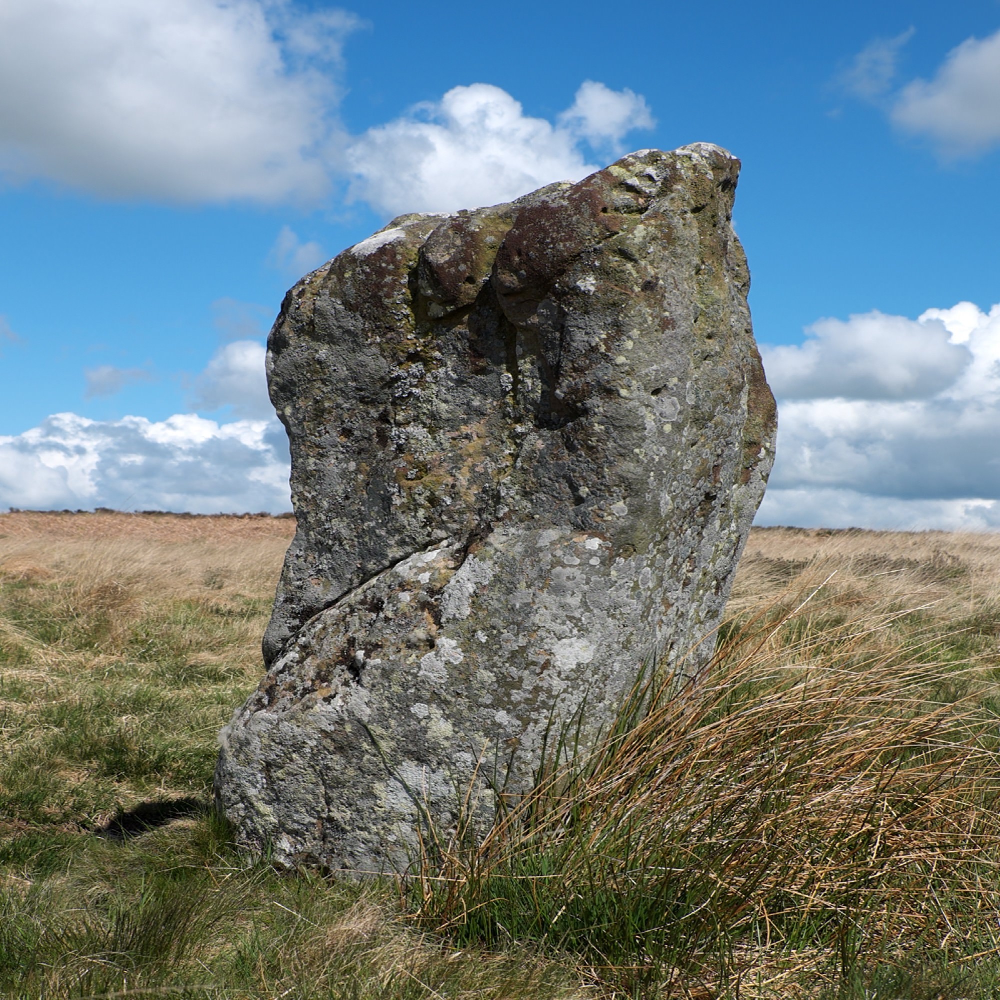
The ‘cup and ring-marked rocks’ that dot the landscape are an even greater mystery than the stone circles. They take several forms: from the simple dimples known as ‘cups’ to more intricate, circular patterns. Today, we refer to the curious markings carved into rocky outcrops and boulders up to 6,000 years ago as ‘rock art’, but we have very few clues as to their meaning. Some suggest they relate to the spiritual paths of the dead; other, more prosaic theories suggest they show routeways and boundaries.
There are more than 1,000 such sites in Northumberland, but some are a lot more impressive than others and few are signposted. They’re often located on featureless low moorland or in the middle of farmers’ fields, so there’s an outside chance of simply stumbling across them if you spend a lot of time walking in the Northumberland countryside. But don’t expect sophisticated, hieroglyphic-style characters; these are simple markings, sometimes little more than indistinct indentations on stones and boulders.
The largest decorated rock in England is at Routin Linn, a couple of miles east of the historic village of Ford. It’s covered in dozens of carvings and never fails to impress. Tucked away in woodland and with no signposting, it’s not easy to find. More easily accessible is Lordenshaw, this airy hill site, at the eastern end of the popular Simonside ridge and with its own car park, is an archaeologist’s dream.
As well as having at least 50 examples of rock art, it is also home to a Bronze Age cemetery, two Romano-British farmsteads, a medieval field system and an Iron Age fort.
Iron Age tribes
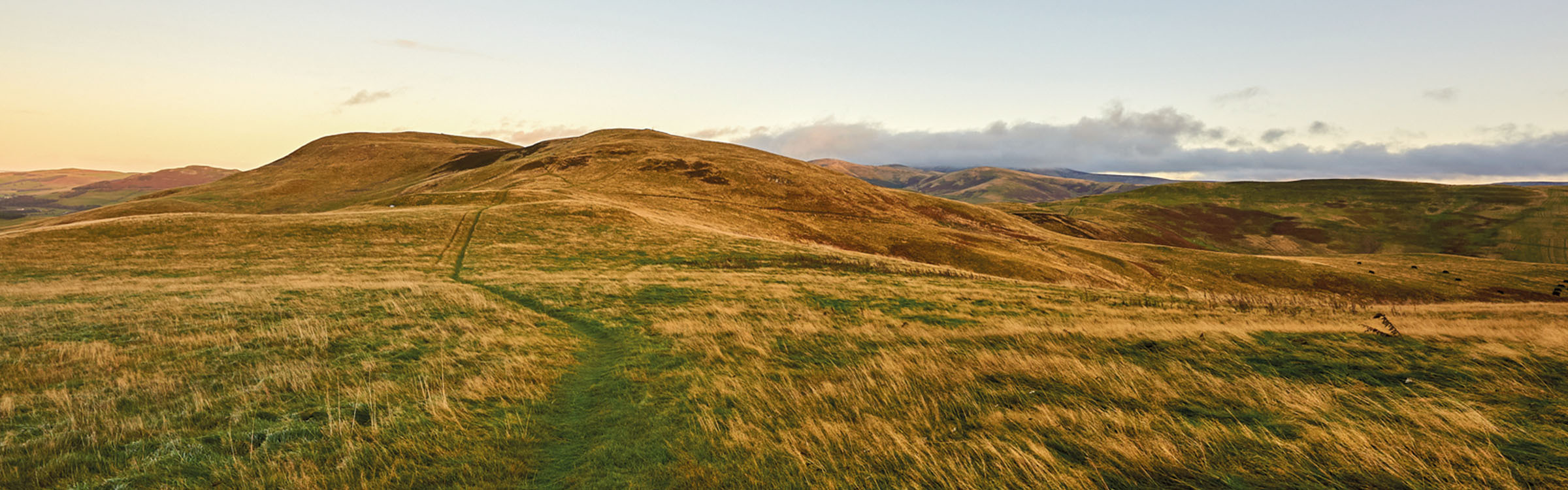
Which brings us neatly to another riddle from Northumberland’s past… the so-called ‘forts’. These were built largely on hill-tops in locations today regarded as remote. Some of the best known are on the moorland flanking the Breamish Valley and on the uplands along the north-eastern edge of the Cheviot Hills. The largest is Yeavering Bell, a few miles west of Wooler. A hike up on to this conical-shaped hill leads you through the ancient, moss-covered stone ramparts. These would once have been almost three metres high and just as thick. The summit area contains the earthwork remains of the platforms where 125 timber-built roundhouses were once located, home to members of the Votadini people, a tribe of Celts that lived in an area that stretched from the Firth of Forth in Scotland down to the River Tyne.
There are about 15 named hillforts in Northumberland, but were they really ‘forts’? Some, despite their hilltop locations and ramparts, are barely defensible. Were these settlements more symbolically defensive? Did some of them perform ceremonial functions? Were Iron Age people really as warlike as we’ve often believed? These are just some of the questions modern archaeologists are asking, casting doubt on the accepted wisdom of previous generations.
The Romans
The mystery and the doubts start to disappear with the arrival of the Romans. When we wander the archaeological sites left behind by these Mediterranean invaders, we’ve got a much better idea of what they intended and how they lived. It may have been nearly two millennia ago, but we’re pretty certain that we know why they built what has become Northumberland’s most famous historic feature – Hadrian’s Wall.
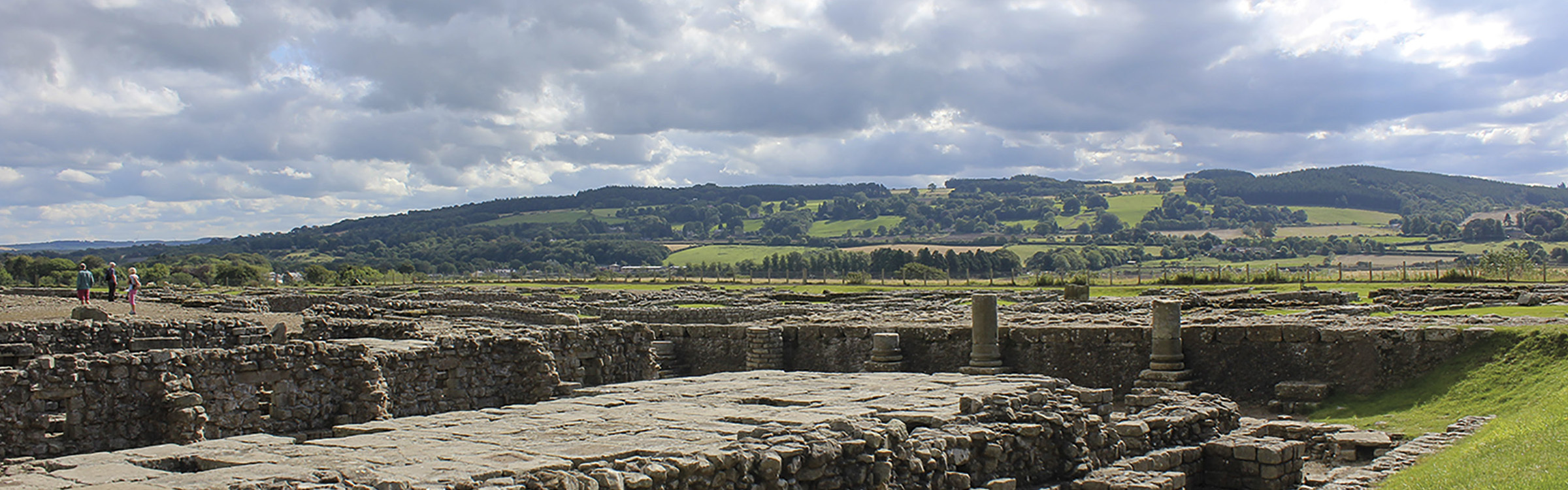
It was in AD122, while on a visit to Britain, that the Emperor Hadrian ordered a defensive wall to be built against the Pictish people to the north. Over the next six years, professional soldiers, or legionaries, built a wall almost five metres high and 80 Roman miles long (73 modern miles) from Wallsend in the east to Bowness-on-Solway in the west. The impressive remains that can be seen today include the massive Housesteads Fort with its famous, flushable toilets; the substantial remains of the bathhouse at Chesters Fort; and the ongoing excavations at Vindolanda, the source of some of the most exciting Roman finds in the country, including hundreds of wooden tablets that are among the oldest handwritten documents ever discovered in Britain.
But, of course, it’s the wall itself that forms the most remarkable sight of all. For mile after mile, the turf-topped remains of the Roman fortification snake their way along the crest of the Great Whin Sill’s distinctive, undulating ridge.
This dolerite rock is an integral part of the defences, with its steep, often craggy northern slopes forming a formidable barrier to any would-be attackers.
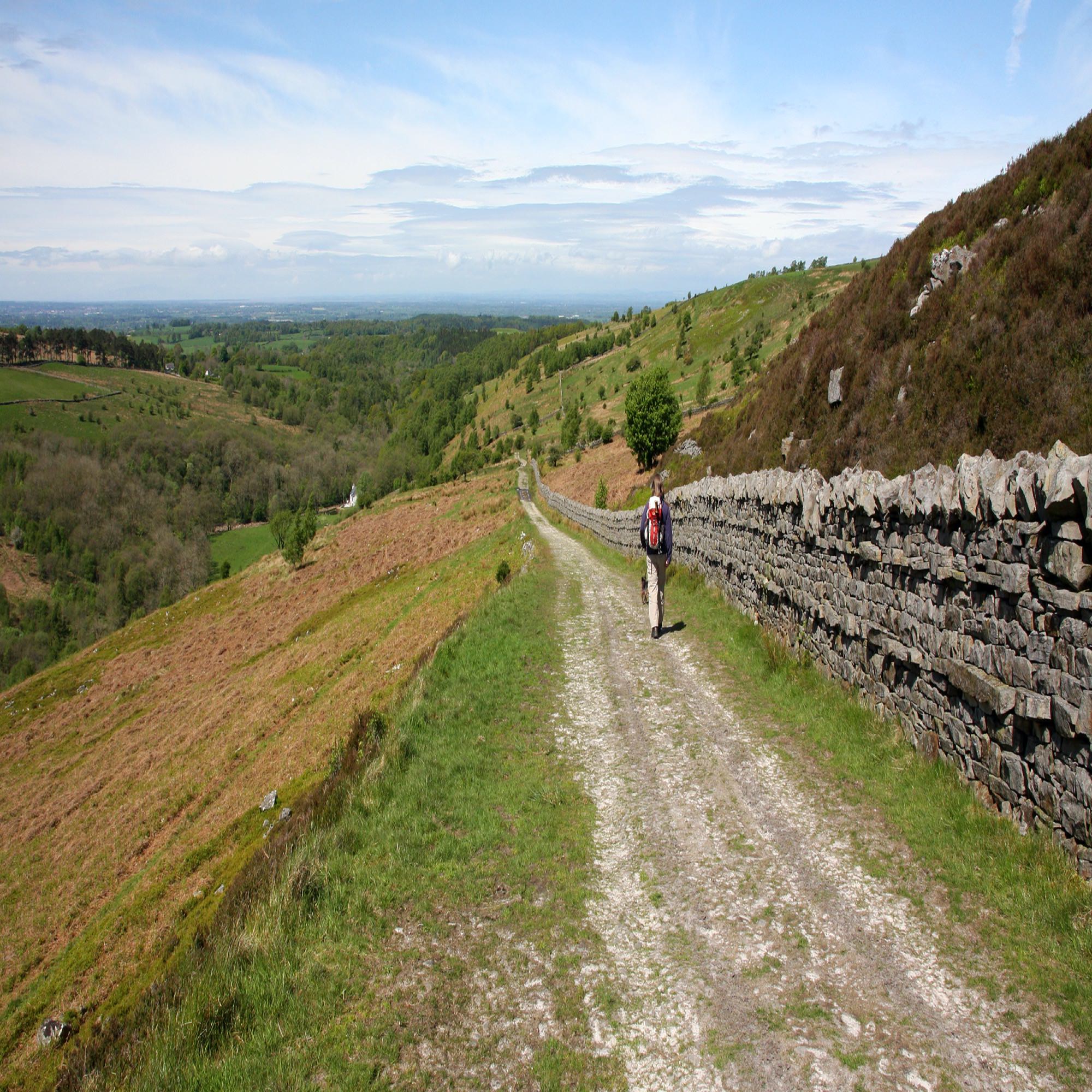
From Greenhead, close to the Cumbrian border, all the way to Sewing Shields, east of Housesteads, the wall religiously follows the lie of the land, soaring and plummeting repeatedly – hard going for anyone attempting the National Trail that now accompanies the wall on its journey coast to coast.
Lumps and bumps
For some of Northumberland’s archaeological sites, the walker needs to remember to bring an extra bit of kit alongside their usual map, compass and waterproofs – their imagination. Sometimes, all you’ll see are the lumps and bumps that, to the untrained eye, say ‘archaeology’ but little else. The Roman marching camps at Chew Green form one of those sites. A long, long way from anywhere, tucked up against the Scottish border and fringed by the Ministry of Defence’s vast Otterburn Training Area, you really need to open your mind to the landscape if you’re going to make the effort to visit the site and make sense of its complex earthworks.
Similarly, a tiny fenced enclosure on the coast near Howick was the unassuming site of an exciting discovery at the start of this century. Archaeologists digging here from 2000 to 2002 unearthed a rare example of a Mesolithic hut. Radiocarbon dating from hearths inside the home, show it was built in about 7800BC, making it Northumberland’s oldest occupied site and among the oldest in the UK. Walkers pass it by all the time, on a track leading down to the coast, but it’s easy to miss. Swamped by long grass in the summer, at times you can hardly even make out the ‘lumps and bumps’.
Stepping back in time
Slightly more tangible but still subtle in terms of their effect on the landscape are the ancient routeways that criss-cross Northumberland. These include Roman roads such as the Maiden Way, Dere Street and the Stanegate, as well as cross-border trading routes such as Salter’s Road and Clennell Street. Most of these are still used as public highways in one form or another. Sections of the busy A1 and A68, for example, follow the route of Dere Street, which the Romans built to link their settlement at Eboracum (York) with their northernmost outposts along the Antonine Wall in Scotland. Clennell Street, at the other extreme, is now a sedate restricted byway used by walkers, horseriders and cyclists. Referred to as the ‘great road of Yarnspeth’ in medieval documents, it used to be one of the most important routes for drovers moving cattle from Scotland to markets in England. It crosses the border on the main, windswept ridge of the Cheviot Hills, just northeast of Windy Gyle, at a point nearly 550m above sea level.
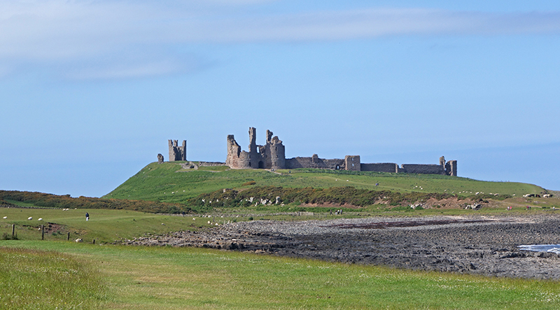
Alongside countless medieval sites such as the dramatic cliff-top ruins of Dunstanburgh Castle and more modern remains such as the ruins left behind by the North Pennine lead miners of the 18th and 19th centuries, all of these antiquities help to shape the Northumberland we see and experience today. Adding layer of history upon layer of history, they are not simply isolated features within the countryside – they form an integral part of that landscape, bringing an extra dimension to an already beautiful and atmospheric part of the country.

Walking in Northumberland
36 walks throughout the county - coast, Cheviots, Hadrian's Wall and Pennines
£14.95
Guidebook to walking in Northumberland. 36 graded walks of 4 to 14 miles, from the beautiful coast with its immense, empty beaches and dramatic, crag-top castles to the remote hills of the Cheviots and Pennines. Includes Hadrian's Wall, Lindisfarne Priory, Kielder, Berwick, Bamburgh and Dunstanburgh Castles and more.
More information