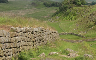
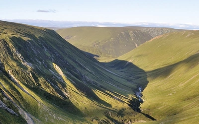
Is Skye's Cuillin Ridge on your bucket list? If so, you're in luck! Get 20% our guidebook to this iconic route and other scrambling guidebooks in our range - use code CUILLINRIDGE at checkout. Offer ends 30th April.
Walk 2 - Menhir On Machrie Moor

Falling in love with Arran - the so called Scotland in Miniature

Natalie explains how she fell in love with Arran - the so called Scotland in Miniature - when walking there with some friends.

When it comes to places, I am a firm believer in love at first sight. So it was with the Isle of Arran. I visited for the first time at the end of March, with two friends, and we all three instantly fell under the island’s spell. The vision of its snow-capped mountains rising above the Ayrshire coast was so beautiful and unexpected that it seemed other-worldly, and the ferry crossing across a mirror-calm Firth of Clyde only reinforced those first impressions.

I had been looking forward to our trip ever since I first decided to visit Arran after flicking through Paddy Dillon’s guidebook one day. There was so much that appealed to me – from the enchanting and varied landscapes (‘Scotland in miniature’) to the island’s rich archaeology – and it was also far more accessible than some of the other Scottish regions on my ever-growing bucket-list.

Holidaying in March, we knew we were taking a bit of a gamble but, as it turned out, we were very lucky to have three days of glorious sunshine before the weather turned. The second half of the week was typically ‘dreich’ with the cloud-base getting lower and lower until, by the Thursday, everything was shrouded in fog.

Nonetheless, we enjoyed a fantastic selection of walks. We opted for two longer routes at the start of the week and then contented ourselves with more leisurely strolls in the latter part, taking in local points of interest and beauty spots. Here is a summary of our itinerary:

Walk 1 – Cock of Arran from Lochranza

This route had been recommended by Cicerone’s Jonathan and Lesley and seemed like a perfect warm-up for our planned ascent of Goat Fell. We parked in Lochranza and after a brief detour to explore the castle, picked up the road beside the medical centre that would take us across the bridge to the other side of the loch. As we passed the golf course, I noticed some large animals grazing, and to my surprise, realised they were deer. The majestic beasts seemed far larger than the occasional red stag I’d encountered closer to home in Grizedale Forest, and all had impressive sets of antlers.

We followed the road round past a shingle beach and up a gentle incline, enjoying fantastic views across the loch to the castle. There is a cottage at the top of the road with picnic tables and a small craft workshop but, unfortunately, being so early in the year, it was all shut up.

The path around the headland was a delight. The sea lay calm and blue below us and visibility was excellent, allowing for clear views across to the Kintyre peninsula. The air was heavy with the coconut scent of gorse, and the sun warmed our backs as we ambled along on the easy track. We ate our picnic lunch on the shore at the Fairy Dell.

From there on, the walk became trickier as the path negotiated the rocky terrain of An Scriodan. We made slow progress on route to the Cock of Arran and it felt like a long way to the white cottage at Laggan. From the buildings, a path rises steeply before traversing westwards to reach Bearradh Tom a’ Muidhe saddle between the low hills of Torr Meadhonach and Creag Ghlas Laggan. We somehow missed the main path and ended up on a sheep-trod, which made things rather more difficult until we realised our error and clambered up the bank to join the main track.

On reaching the high ground, the views opened up. The jagged teeth of Ceum na Caillich (the Witch’s Step – a fearsome bad step on the ascent of Caisteal Abhail) were silhouetted against a blue sky, sun catching the lingering snow. The clear path traversed gently above Glen Chalmadale, with the white buildings of the Isle of Arran Distillery clearly visible down in the valley below. We gradually lost height and at last met up with the road beside the golf course, which took us back to our start-point in Lochranza.

See Walk 35 in Paddy Dillon’s guidebook.

Walk 2 - Menhir On Machrie Moor

Walk 2 – Machrie Moor Stone Circle

Having seen photos and read about the standing stones in the Cicerone guidebook and on the internet, I was very keen to see them. We decided to visit the stones on our way back from Walk 1, following the clear trail from the designated carpark between Machrie and the tiny hamlet of Tormore. It was a short walk, but one which offered magnificent views of the surrounding countryside.

After about 1km, we encountered the fenced Moss Farm Road Stone Circle: this was impressive enough, but it paled into insignificance when compared to the main menhirs. The path continued and after crossing a low wall, we were greeted with a view of the Machrie Moor stones. It was an awe-inspiring sight, as each stone is over 3.5m tall.

We decided to visit the solitary stone first, as there was another group admiring the three stones to the east. I then got very wet feet trying to take a shortcut to the other stones. There were numerous other ancient monuments on the moor as well, including further stone circles, hut circles and two large round stones that looked a bit like millwheels. After taking some time to explore the site, we retraced our steps back to the car.

See Walk 23 in Paddy Dillon’s guidebook.

Walk 3 – Goat Fell

In my mind, Goat Fell, the highest summit on Arran, was a ‘must’. We had considered making an ascent from Corrie, which would allow us to visit the north top and possibly – by means of a short detour – Mullach Buidhe as well, however, we were not sure what conditions would be like on top as there was still some patchy snow, especially in the eastern gullies. So we opted for the tourist route from Brodick, starting from the Isle of Arran Brewery at Cladach.

We set off quite early, which meant we had the place largely to ourselves. The initial wooded section was on good tracks and provided a welcome warm-up. As we broke free of the tree-line, the path became slightly more uneven, and after crossing a dancing beck, we passed through rocky heath making our way up towards the east ridge. It was still quite easy going until we joined the ridge-path, from which point we had to pick a course between boulders and the occasional patch of soft but slippery snow.

The views were stunning and only improved as we gained height. After around half an hour of walking and boulder-hopping along the ridge, we reached the summit trig-point, where we were rewarded with a breathtaking 360° panorama. We could look along the south ridge to Brodick Bay, with Holy Island rising beyond and Ailsa Crag a small pyramid in the distance. To the east was the ridge we had ascended, running almost parallel to the east ridge of Mullach Buidhe. The broad bulk of Beinn Tarsuinn commanded the view to the west, with Kintyre visible on the horizon beyond. But it was the northern vistas that really captured the gaze: in the foreground, the dramatic rocky peaks and ridges of Caisteal Abhail, Cir Mhòr and North Goatfell; in the mid-distance, the Firth of Clyde, Ayrshire coast, Cumbraes and Bute; on the horizon, the distant hills of Jura and the snow-clad mountains of the Highlands. It was a place to linger, to savour, a place to celebrate the joy of being alive.

We ate our lunch and then made our descent back to Cladach, taking a slightly different route at the bottom through the grounds of Brodick Castle. On the far side of the road near the brewery, we came upon a beautiful sandy beach. Neil and Charlie cooled their feet in the freezing water of Brodick Bay while I (coward that I am!) admired the views. Then, suitably refreshed, we headed into Brodick for traditional music and cold cider at Fiddlers’ Bistro.

See Walk 1 in Paddy Dillon’s guidebook: we started our walk from the brewery rather than the ferry terminal.

Walk 4 – King’s Cave from Blackwaterfoot

Our next walk was on the west side of the island: we decided to visit the King’s Cave near Blackwaterfoot. It was here that Robert the Bruce is said to have had his famous encounter with the spider, whose perseverance inspired him to continue his quest for the crown of Scotland.

After parking at the edge of Blackwaterfoot, we followed a track along the edge of the golf course. We then skirted around the back of some earthworks – the remains of an ancient fort – to emerge on the shore, where we picked up the Arran Coastal Path. The clear trail led through scrub, russet bracket and blooming gorse, beside the shingle shore and turquoise waters. We ate our sandwiches sat on a large piece of driftwood, enjoying the sunshine and tranquillity. Continuing on our way, it wasn’t long before we came to the caves.

The King’s Cave is one of at least fifteen caves on this stretch of coast and is by far the largest. We were all impressed and surprised by its size. We took some time to examine the fascinating historic graffiti: a cross motif attests to a Christian presence and we also found what appeared to be Pictish designs representing horses and a man.

Returning to Blackwaterfoot, I paused to build a pile of stones on the shore at a spot where there were lots of similar cairns. Instead of passing around the back of the cliffs, we decided to follow the shoreline round Drumadoon Point: although we rather expected the scree to make for tough going, there was a clear path that wove its way between the boulders. The route offered excellent views of the columnar cliffs and also took in a fine viewpoint on the edge of the golf course. It was an easy walk back to the village, where we stopped for coffee and cake before making our way back to Brodick.

See Walk 22 in Paddy Dillon’s guidebook. We retraced our steps back to Blackwaterfoot after the visiting the caves (taking a slightly different route around the foot of the cliffs at the Doon) rather than walking along the road.

Walk 5 - Glen Rosa
Walk 5 - Glen Rosa

Walk 5 – Glen Rosa

Our cottage was located on the road to Glen Rosa. Since the mountains were now blanketed in cloud, we opted to take a stroll up the valley. We didn’t see a soul as we strode up the broad track past the campsite, although we startled the occasional pheasant from the heath. The track made for easy walking and loosely followed the course of Glenrosa Water. We did not go too far – just up to a little footbridge near some low falls – but we enjoyed the atmospheric setting, with the higher mountains all obscured by cloud and the trees still bare. It felt wild and beautiful and somehow, quintessentially Scottish.

Walk 6 – Glenashdale Falls

Thursday was wet, with low cloud covering all the hills, however we were determined to get out on a shortish walk in order to avoid being stuck inside all day. Glenashdale seemed the perfect choice: the forest would shelter us from the downpour and the dramatic waterfalls would be all the more spectacular for the rain. We parked on the edge of Whiting Bay and followed a delightful path up through first deciduous and then pine forest. We were quite sheltered in the trees and it was easy to forget the poor weather. The ground was soft with fallen needles and the evocative scent of pine filled our nostrils.

It was a steady climb but at last we came to the wooden viewing platform beside the falls. It is only on stepping out to the end of the balcony that you really appreciate just how high they are! The thunderous cascade plunges some 40m over two steps and is truly a breathtaking sight.

We crossed the river a little higher up, to descend on the other side, taking in an Iron Age fort and a vantage point offering great views back to the falls. Before we knew it, we were back at the bottom and enjoying delicious cake in the conveniently situated Coffee Pot café.

See Walk 11 in Paddy Dillon’s guidebook: we walked the route in reverse.

Walk 7 – Kildonan Beach

The weather really wasn’t up to much on our final day, so we decided to take a drive around the island. Our explorations eventually took us to Kildonan, one of the most southerly villages on Arran, and we took a short stroll along the beach to stretch our legs and take in the (by now, slightly bracing) sea air. I had read somewhere that this is a good place to spot seals, but we didn’t see any. There was some interesting geology though (including what I took to be an igneous dyke) and views to the low-lying island of Pladda with its lighthouse, and Ailsa Craig beyond. We had the white sands all to ourselves and soon filled our pockets with coloured shells, broken pottery and sea-glass. Eventually, however, the persistent drizzle drove us back to the car, and we found a warm welcome and tasty food in Velo Café in nearby Lagg.

Other activities

There was the odd morning or afternoon when it was just too wet and foggy for walking and so we took the opportunity to visit some of Arran’s other attractions. The Isle of Arran Heritage Museum proved an interesting place to while away an hour or two, with exhibitions about the island’s ancient and more recent past. Arguably no visit to Scotland is complete without a trip to a distillery: the Isle of Arran Distillery tour offered a fascinating insight into the production of the local malts and I can vouch for the samples too! We also visited the swimming pool and sauna at Auchrannie Resort and a number of very nice cafés and tearooms.

I thoroughly enjoyed our trip to Arran. Goat Fell, Machrie Moor Standing Stones and the King’s Cave were particular highlights, but all of our walks were very pleasurable and wonderfully scenic. I would love to return to climb some of the other mountains on the island.

Natalie

To read more articles like this get our newsletter

Sign up for 20% off your next purchase and to be the first to hear about exclusive competitions, special offers, and news from Cicerone.