The GR10: Everything You Need To Know
The Pyrenees, the mountain chain which forms the border between France and Spain, stretch over 400km from the Atlantic Ocean to the Mediterranean Sea, and at Pico Aneto (entirely within Spain) they reach their highest point at an ice-frosted 3404m. Grande Randonnées, or GR footpaths, are long-distance walking trails throughout Europe. The GR10 is a superb long-distance trail that runs across the entirety of the French side of the Pyrenees from the Atlantic to Mediterranean. Find out more about the GR10, with answers to FAQs and a summary of the 4 sections and 55 stages below!
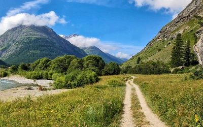
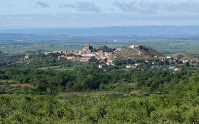
The GR10 is an extremely well-waymarked route following good mountain paths, with only a few tough stages with boulderfields to cross and occasional scrambling. Towns and villages are frequent so finding accommodation and supplies is rarely a problem.
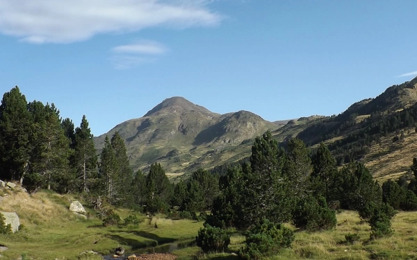
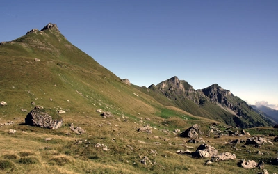
Initially the GR10 follows ridges over the steep rolling hills of the Basque Country before reaching the impressive limestone peaks at the western end of the High Pyrenees. After the town of Bagnères-de-Luchon the GR10 passes into the less-frequented Ariège where the route crosses a succession of deep valleys with occasional returns to spectacular Alpine terrain.
As the Mediterranean is approached the Canigou massif dominates the scene and the terrain remains mountainous with the final 1000m peak being only a few miles from the route’s end at Banyuls-sur-Mer. The highlight of the GR10 for many walkers isn’t the mountains or the fauna (as diverse as this is), but the magnificent wildflower meadows and shimmering lakes in which great peaks are reflected. This is an unforgettable walk through a stunning mountain range.

Trekking the GR10
Through the French Pyrenees: Le Sentier des Pyrenees
£18.95
Guidebook to walking the GR10, the Sentier des Pyrenees, a 955km trek across the French Pyrenees from Hendaye on the Atlantic coast to the Mediterranean coast at Banyuls-sur-Mer. The book describes 55 stages, with information on planning, transport, accommodation and facilities. Walk the entire GR10 in around 45 days or in shorter trips.
More informationFAQs and Advice
How long is the GR10 trail?
954km in length with a total climb of 53,000m. The GR10 is too long for most hikers to do in a single trip and most will break it up into sections and walk it over several years.
How long does the GR10 take to complete?
For a fit walker, it would be possible to complete the entire trek in around 45 days by combining stages.
A goal of 45 days would require some planning ahead to ensure daily distances are realistic and accommodation options fit the intended schedule. It would also require the weather to be reliably on your side and wouldn’t allow for many diversions off the main route, which would be a great pity as these diversions and side trails often lead to the most rewarding experiences and memories. Therefore, we would suggest adding in an extra week at the least.
What is the best time of year to walk the GR10?
The best months to walk the GR10 are mid and late June, July, August and September.
If you are only intending to walk sections of the GR10 in the Basque Country, you may prefer May, June or October when the weather will be cooler. However, trying to complete the entire GR10 in October would be very ambitious and should not be attempted by anyone without experience in snow and winter weather. Also, most of the refuges are unstaffed by October so you’d need to be self-sufficient.
You should be aware that the main holiday season is July and August and that some facilities are only open during those two months. July and August are hot and busy throughout the range and the later into summer you go the more parched the countryside becomes.
Which direction should I walk the GR10 in?
We suggest trekking the GR10 from the Atlantic to the Mediterranean. This means that you have the prevailing wind/rain on your back and you have time to acclimatise to the heat before reaching the Mediterranean, with the added advantage that in hot weather the steep climbs can often be done in the shade of early morning. It would still be possible to trek from the Mediterranean to Atlantic.
How difficult is the GR10?
The GR10 is a serious expedition so you should have previous experience of backpacking or long-distance walking before attempting this fantastic route.
On the GR10, especially in the Ariège, you are often traversing very steep slopes where a fall could have fatal consequences. It is not the difficult terrain – there is very little difficult terrain on the GR10 – it is the careless slip on an easy but exposed path that is potentially dangerous. It is strongly recommended that you use two walking poles and learn to use them effectively to prevent a careless slip on a steep traverse.
What should I pack to walk the GR10?
Keep your load as light as possible. If you don’t need it, don’t carry it!
- You will need a sheet sleeping bag or lightweight sleeping bag for use in refuges or some gîtes d’étape. If you are using accommodation you may still want to carry a sleeping bag and camping mat to enable you to bivouac when required.
- Your waterproofs should be able to cope with thunderstorms and heavy rain.
- Shorts are the preferred legwear of most hikers in the high summer.
- A sun hat is strongly recommended and you should use plenty of sun-screen.
- Good quality lightweight boots or sturdy walking they have a good tread.
- Be warned that even in summer it can get cold at night. On some of the higher elevation night stops the temperature can drop to almost zero, even in August, so you’ll want a fleece and a thermal is a good, light-weight, addition.
- If you are camping, you should have, as a minimum, containers capable of carrying three litres of water.
- It is strongly recommended that you use two walking poles. Mini spikes or even full crampons may be needed in early season in a high snow year.
- If you are carrying any electronic devices needing recharging, remember to carry a continental adaptor.
Where should I stay on the GR10 Route?
There is a wide range of accommodation on the GR10.
- Hotels vary greatly in quality and cost but even the cheapest offer a high standard of comfort. An auberge is the equivalent of an English inn.
- Chambres d’hÔtes are private houses offering accommodation similar to the British ‘bed & breakfast’. They are a fantastic way to get a more intimate look at rural French life with dinner (and sometimes breakfast) often being communal affairs hosted by the owners.
- Gîtes d’étape are a network of cheap accommodation aimed primarily at walkers. They often have dormitory accommodation, but many also have smaller rooms. Most, but not all, will offer evening meals, breakfast and picnic lunches. Some will be open for snacks and drinks during the day. Most will have a kitchen for the use of visitors. Don’t get confused by the ‘gîte’ designation; these are mainly chambres d’hÔtes rather than gîtes d’étape.
- Manned refuges are mountain huts (today some are more like full blown hotels!) that offer accommodation, possibly in dormitories. In summer many of them have a drink and meals service, open to both residents and non-residents, and will usually provide packed lunches.
- Unmanned refuges are open year round for the use of mountaineers and walkers. They are equivalent to the Scottish ‘bothy’ and range in quality from purpose-built buildings, which are well maintained by mountaineering clubs, to buildings that are little better than unmaintained cow sheds. Sometimes they are in fact just cow sheds!
- Some campgrounds will have cabins, static caravans or gîte d’étape accommodation.
- If desperate ask at a village bar-restaurant; they will often know locals who are willing to offer accommodation outside the official system.
Useful Links & Resources
GR10 Maps:
The cheapest way to get a complete detailed map is to buy the FFRandonnée TopoGuides, which come in four volumes complete with map pages at 1:50,000.
Mountain Refuges:
The French Alpine Club site gives up-to-date information on mountain refuges.
Weather:
An accurate weather site is MeteoBlue. For severe weather warnings in Europe, visit MeteoAlarm.

The Sections - GR10 Route
With a walk of this magnitude, it makes sense to sort it into sections, with lots of walkers completing the GR10 in sections over months, or years. There are good bus and rail links throughout the French Pyrenees so there is plenty of choice when splitting into sections. For convenience, the Cicerone guidebook has been divided into four sections, which fit in well with the rail links.
Section 1: Hendaye-Plage to Etsaut (Stages 1–12)
Section totals:
- Distance: 221km
- Ascent: 11,300m
As the GR10 leaves the border town of Hendaye on the Atlantic coast it follows ridges over the steep, grassy and wooded rolling hills of the Basque Country. After nine stages there is a rapid transition to the steep limestone peaks at the western end of the High Pyrenees.
Section 2: Etsaut to Bagnères-de-Luchon (Stages 13–26)
Section totals:
- Distance: 253km
- Ascent: 14,400m
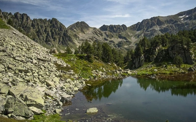
This is the most spectacular section of the GR10, passing through the High Pyrenees, which rise to over 3000m, crossing high passes that may be snow-covered well into summer. The fantastic scenery in this section reaches its visual highlights as you pass around the Pic du Midi d’Ossau, Vignemale, Gavarnie and the Néouvielle massif.
Section 3: Bagnères-de-Luchon to Mérens-les-Vals (Stages 27–43)
Section totals:
- Distance: 265km
- Ascent: 17,600m
In this section, the border between France and Spain (or Andorra) is well north of the watershed and the GR10 passes through the Ariège. These mountains aren’t quite as high as the High Pyrenees, but the route crosses a succession of deep valleys cut out by the huge glaciers that flowed north from the Pyrenees in the last Ice Age, meaning that there is a lot of ascent. The Ariège has never been as popular as the High Pyrenees so there is often a feeling of remoteness as you walk through a land of deep forests and across pastures where a traditional shepherding lifestyle remains strong. This region is also a stronghold for brown bears and other wildlife. Facilities for walkers are harder to find.
Section 4: Mérens-les-Vals to Banyuls-sur-Mer (Stages 44–55)
Section totals:
- Distance: 215km
- Ascent: 9700m
The first few days of this section are through spectacular Alpine terrain, after which the mountains become gentler. After the dominating Canigou massif is passed, the terrain becomes drier and notably more Mediterranean but remains mountainous, with the final 1000m peak being only a few miles from Banyuls-sur-Mer.

The Stages
For a detailed breakdown of every stage, including information on accommodation, facilities, the local area and the trail, buy the Trekking the GR10 Guidebook by Brian Johnson & Stuart Butler.
Section 1 Hendaye-Plage to Etsaut
- Stage 1 Hendaye-Plage to Olhette
- Stage 2 Olhette to Ainhoa
- Stage 3 Ainhoa to Bidarray
- Stage 4 Bidarray to Saint-Étienne-de-Baïgorry
- Stage 5 Saint-Étienne-de-Baïgorry to Saint-Jean-Pied-de-Port
- Stage 6 Saint-Jean-Pied-de-Port to Gîte d’étape Kaskoleta
- Stage 7 Gîte d’étape Kaskoleta to Gîte d’étape Chalets d’Iraty
- Stage 8 Gîte d’étape Chalets d’Iraty to Logibar
- Stage 9 Logibar to Sainte-Engrâce (Senta)
- Stage 10 Sainte-Engrâce (Senta) to Refuge Jeandel
- Stage 11 Refuge Jeandel to Lescun
- Stage 12 Lescun to Etsaut
Section 2 Etsaut to Bagnères-de-Luchon
- Stage 13 Etsaut to Gabas
- Stage 14 Gabas to Gourette
- Stage 15 Gourette to Arrens-Marsous
- Stage 16 Arrens-Marsous to Refuge d’Ilhéou
- Stage 17 Refuge d’Ilhéou to Cauterets
- Stage 17A Refuge d’Ilhéou to the Pont d’Espagne (via Col de la Haugade)
- Stage 18 Cauterets to Refuge des Oulètes de Gaube
- Stage 18A Cauterets to Luz-Saint-Sauveur (via Col de Riou)
- Stage 19 Refuge des Oulètes de Gaube to Chalet-refuge la Grange de Holle
- Stage 20 Chalet-refuge la Grange de Holle to Luz-Saint-Sauveur
- Stage 21 Luz-Saint-Sauveur to Barèges
- Stage 22 Barèges to Refuge-Hôtel de l’Oule
- Stage 23 Refuge-Hôtel de l’Oule to Vielle-Aure
- Stage 24 Vielle-Aure to Ger
- Stage 25 Germ to Lac d’Oô
- Stage 26 Lac d’Oô to Bagnères-de-Luchon
Section 3 Bagnères-de-Luchon to Mérens-les-Vals
- Stage 27 Bagnères-de-Luchon to Artigue
- Stage 28 Artigue to Fos
- Stage 29 Fos to Refuge de l’Étang d’Araing
- Stage 30 Refuge de l’Étang d’Araing to Eylie-d’en-Haut
- Stage 31 Eylie-d’en-Haut to Maison du Valier, Pla de la Lau
- Stage 31A Eylie-d’en-Haut to Bonac
- Stage 32 Maison du Valier, Pla de la Lau to Esbintz
- Stage 32A Bonac to Esbintz
- Stage 32B Col de la Core to Estours Valley
- Stage 33 Esbintz to Refuge d’Aula
- Stage 33A Esbintz to Saint-Lizier-d’Ustou using the Tour du Val du Garbet
- Stage 34 Refuge d’Aula to Rouze
- Stage 35 Rouze to Saint-Lizier-d’Ustou
- Stage 36 Saint-Lizier-d’Ustou to Aulus-les-Bains
- Stage 37 Aulus-les-Bains to Refuge des Étangs de Bassiès
- Stage 38 Refuge des Étangs de Bassiès to Marc
- Stage 39 Marc to Goulier
- Stage 40 Goulier to Siguer
- Stage 41 Siguer to Plateau de Beille
- Stage 42 Plateau de Beille to Refuge du Rulhe
- Stage 43 Refuge du Rulhe to Mérens-les-Vals
Section 4 Mérens-les-Vals to Banyuls-sur-Mer
- Stage 44 Mérens-les-Vals to Refuge des Bésines
- Stage 45 Refuge des Bésines to Refuge des Bouillouses
- Stage 46 Refuge des Bouillouses to Planès
- Stage 47 Planès to Refuge du Ras de la Carança
- Stage 48 Refuge du Ras de la Carança to Mantet
- Stage 49 Mantet to Refuge de Mariailles
- Stage 50 Refuge de Mariailles to Refuge des Cortalets
- Stage 51 Refuge des Cortalets to Gîte-refuge de Batère
- Stage 52 Gîte-refuge de Batère to Gîte d’étape l’Ecogîte de la Palette
- Stage 53 Gîte d’étape l’Ecogîte de la Palette to Las Illas
- Stage 54 Las Illas to Col de l’Ouillat
- Stage 55 Col de l’Ouillat to Banyuls-sur-Mer