
Article
Free Royal Mail 48 postage on UK orders. European postage is £3.50 per item. Worldwide postage is £5.50 per item. If you're not happy with your purchase for any reason, we'll give you a full refund.
More information...
Inspirational guidebook to 50 varied walking and backpacking routes in the Hebrides, featuring classics such as the Skye Cuillin and the Paps of Jura, but also many lesser-known routes on Jura, Scarba, Islay, Colonsay, Rum, Eigg, Canna, Muck, Coll, Tiree, Mull, Skye, Raasay, Harris, Lewis, Berneray, North Uist, South Uist, Barra and St Kilda.
Free Royal Mail 48 postage on UK orders. European postage is £3.50 per item. Worldwide postage is £5.50 per item. If you're not happy with your purchase for any reason, we'll give you a full refund.
More information...
This inspirational guidebook describes 50 varied walking and backpacking routes on the Scottish Hebrides islands, set out in a larger format, and illustrated with a range of stunning photographs. The 50 walks are spread across both well-known and remote islands; from Skye, Mull, Rum, the Uists and Barra, Ulva, Iona, Eigg and Muck and more besides. Most of the walks provide a full day for experienced walkers, with a few multi-day backpacking adventures as well as some shorter routes.
The walks also include Hebrides classics, like the Trotternish Ridge, Ben More, Skye and Rum Cuillins, the Paps of Jura and full circuits of smaller islands. Each walk combines clear route description with mapping and spectacular photography, while also advising on the route's facilities, public transport access, length and terrain. The result is a collection of the very best walks with which to uncover the wild and rugged beauty of the Hebrides.
Map key
Overview map
Preface
Introduction
Geology
History
People, language and culture
Wildlife
Plants and flowers
Getting to the islands
Getting around
When to go
Access, camping and bothies
Safety and emergencies
What to take
Maps and route-finding
Mountain weather
River crossing
Biting beasties
Using this guide
The routes
Islay
Walk 1 Rhuvaal and northwest coast
Walk 2 An Cladach and Beinn Bheigier
Walk 3 Ardnave Point
Jura
Walk 4 The west coast of Jura
Walk 5 The Paps of Jura
Walk 6 Ardlussa to Corpach Bay and Am Miadar
Walk 7 Evans’ Walk to Glenbatrick Bay (and return)
Scarba
Walk 8 Cruach Scarba
Colonsay
Walk 9 South Colonsay Coast and Oronsay
Walk 10 Lower Kilchattan to Kiloran Bay
The Garvellachs
Walk 11 Garbh Eileach
Mull
Walk 12 Ben More
Walk 13 Beinn Talaidh via Glen Forsa
Walk 14 Carsaig Arches
Walk 15 Dùn da Ghaoithe
Ulva
Walk 16 Ormaig and the south side
Iona
Walk 17 Around Iona
Coll
Walk 18 Coll’s western tip
Tiree
Walk 19 Around the coast of east Tiree
Walk 20 Tiree’s west coast and three highest points
Rum
Walk 21 A Round of the Rum Cuillin
Walk 22 Kinloch to Harris Bay around the coast
Walk 23 The Guirdil Horseshoe
Eigg
Walk 24 An Sgùrr and Grulin
Canna
Walk 25 Around the coast of Canna
Muck
Walk 26 Gallanach Bay and Beinn Arien
Skye
Walk 27 The Beinn Deargs
Walk 28 Marsco
Walk 29 Blà Bheinn
Walk 30 Elgol to Camasunary
Walk 31 Loch Coruisk
Walk 32 Bruach na Frithe
Walk 33 Glen Ollisdal, Idrigill Point and Macleod’s Maidens
Walk 34 The Trotternish Ridge traverse
Raasay
Walk 35 Dùn Caan, Hallaig and the southern coast
Barra
Walk 36 The Barra watershed
South Uist
Walk 37 Hecla, Beinn Mhòr and South Uist’s wild east coast
North Uist
Walk 38 Eaval
Walk 39 Around the Udal peninsula
Berneray
Walk 40 Around Berneray
Harris and Lewis
Walk 41 Roineabhal and Rodel
Walk 42 The Clisham Horseshoe
Walk 43 North Harris mountains and moorland wilderness backpack
Walk 44 Huiseabhal Mòr, Oireabhal and Huiseabhal Beag
Walk 45 Circuit of Tòdun from Urgha
Walk 46 The Uig Hills
Walk 47 Uig Hills and coast backpack
Walk 48 West side coastal path
Walk 49 Tolstadh to Port Nis heritage walk
St Kilda
Walk 50 The hills and sea cliffs of Hirta
Appendix A Route summary table
Appendix B Glossary
Appendix C Useful contacts
Appendix D Further reading
April 2025
Walk 6, p68, first para:
The bridge over the outflow of the Fishing Loch has been removed for safety reasons and the bridge over the Allt Grundale has been swept away. Please use the following directions at the start of the walk instead:
If driving, cross the bridge over the Lussa River, turn sharply left and park on the grassy area a short way along the track; let the estate know if you’re leaving a car there overnight. Return to the road and turn right to recross the bridge. After 200 metres turn left down a track, soon passing a large shed. The metalled track runs out shortly before reaching a stand of trees, bear left to follow the ATV tracks across the often boggy moorland. Climb steadily along the southwestern side of Glen Grundale, following the more distinct ATV tracks winding through the rough moorland landscape.
November 2019
July 2015
We have belatedly spotted that the map for Walk 7 in this book shows the start/finish point at Glenbatrick Bay, whereas it should be at the other end of the route line, on the A846. Apologies for any confusion caused.
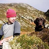
Since moving to Scotland from the south of England in 2006, Peter has developed a passion for the Hebrides. He lives at Rhenigidale on the Isle of Harris with his wife, Fiona, and their Labradors, Dougal and Mara.
View author profile