
Walking the Via Francigena Pilgrim Route - Part 2
Lausanne and the Great St Bernard Pass to Lucca


Walking the Via Francigena Pilgrim Route - Part 2
Lausanne and the Great St Bernard Pass to Lucca
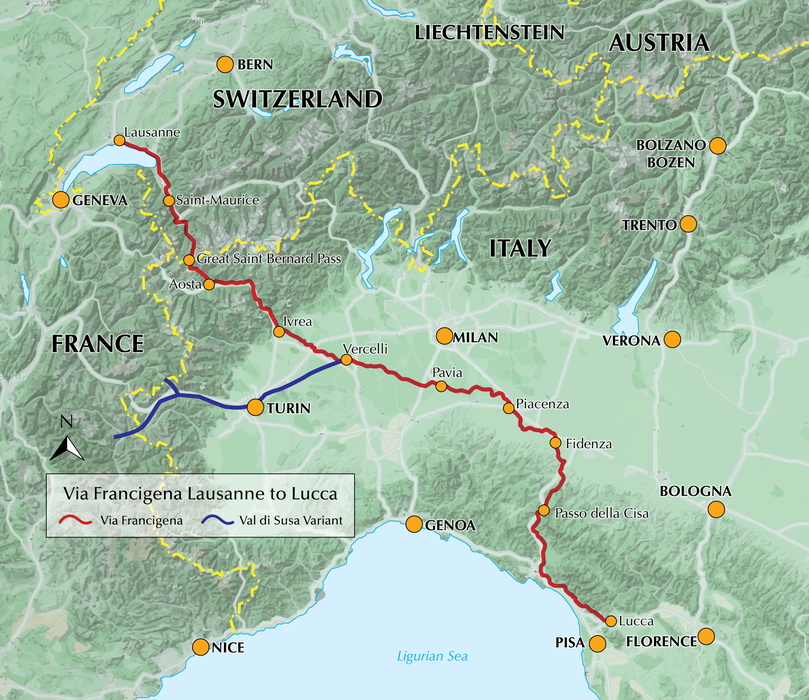
Guidebook to the Via Francigena pilgrim route from Lausanne to Lucca. Starting at Lake Geneva (Lac Léman), this 725km section crosses the Alps at the historic Great Saint Bernard Pass, descends the Po Valley, then climbs to cross the Cisa Pass into Tuscany. Described in 32 stages, with information on facilities and pilgrim hostels.Discover the enchanting stone cloisters, medieval towers, and cobbled villages along the Via Francigena on this central section of the renowned pilgrimage route, a 726 km journey from Lausanne on Lake Geneva to the historic city of Lucca in Tuscany. Walk shaded lakeside paths by Lac Léman, cross the historic Great Saint Bernard Pass, traverse the Po Valley’s cultural heart, and finish among the scenic hills and coastline of Liguria and Tuscany, where medieval villages and vineyards meet stunning sea views.
Designed for modern-day pilgrims and those seeking a reflective walking experience, this comprehensive Cicerone guidebook breaks this section of the Via Francigena into 32 manageable daily stages. The route is described from north to south, beginning in Lausanne on Lake Geneva and concluding in the medieval Tuscan city of Lucca.
- Each stage features a detailed 1:100,000 route map to guide your journey across the diverse landscapes of the Via Francigena, with enhanced 1:25,000 city maps for Lausanne, Martigny, Aosta, Pavia, Fidenza, and Lucca, providing clear navigation through these key urban centres.
- Comprehensive, step-by-step directions guide you along the route, whether crossing the vineyards around Vevey, the alpine valleys approaching the Great St Bernard Pass, or the rolling hills of Tuscany, with each section supported by downloadable GPX files for GPS devices and smartphone apps.
- For every stage, you’ll find start and finish points, precise distances, total ascent and descent, estimated walking times, and a terrain summary, helping you plan for days that might take you from the lakeside promenades of Montreux to the medieval streets of San Gimignano.
- Accommodation and refreshment options are listed for each stage, highlighting welcoming places to stay and eat in towns and villages, including Lausanne, Montreux, Aigle, Aosta, Pavia, and Lucca, as well as trail-side facilities and services in smaller settlements.
- A handy trek planner and route summary table let you customise your itinerary, whether you want to linger in the Roman spa town of Aosta, explore the historic abbeys of Pavia, or enjoy the world-famous cuisine of Parma.
- With detailed mapping and practical advice, this guide ensures a safe, enjoyable, and culturally rich Via Francigena walking experience, whether you’re tackling alpine passes, following riverside paths, or exploring the cobbled streets and lively piazzas of Italy’s northern cities.
Plan your Via Francigena adventure from Lausanne to Lucca with confidence, and experience one of Italy’s most iconic long-distance pilgrim walks with this definitive guidebook.
Via Francigena Pilgrim Route – Part 2 (Lausanne to Lucca) - Quick Facts
Location: Switzerland & Italy – Lake Geneva (Lac Léman) to Lucca, Tuscany
Distance: ~726 km / ~451 miles
Typical duration: ~1 month on foot
Start: Lausanne, Switzerland (Lake Geneva)
End: Lucca, Tuscany, Italy
Route format: Linear long‑distance pilgrimage walk with varied terrain (lakeside, Alpine pass, plains, hills)
Stages: 32 stages with detailed daily descriptions
Difficulty: Moderate – includes Alpine crossings and varied terrain; graded stages, no special gear in season
Best season: Spring to autumn (Alpine passes open mid‑summer)
Author Highlight
“It may be true that all roads lead to Rome – but few roads lead to Rome with as many marvels as the Lausanne to Lucca stretch of the Via Francigena. This glorious route begins along the shaded promenades of Lake Geneva (Lac Léman), turns upward on breathtaking mountain trails to cross the Alps, descends to flat farmland roads in the Po Valley, climbs into mountains again at Cisa Pass, and hugs the hillsides near its end in Lunigiana to enjoy sweeping vistas of the sea. Sprinkled along the way are the stone cloisters of ancient convents, the crumbling towers of tall castles, the cobblestone streets of quaint villages, and the contrasting cultures of two Swiss cantons and six Italian regions.”
- The Reverend Sandy Brown, author of Walking the Via Francigena Pilgrim Route - Part 2
Printed book
A guidebook with detailed route descriptions, stage breakdowns, accommodation listings, profiles and maps - everything you need on the trail.
ISBN
9781786310866
Availability
Published
Reprinted
13 Aug 2024
Published
23 Jun 2021
Edition
First
Pages
256
Size
17.20 x 11.60 x 1.40cm
Weight
300g
eBook
The complete digital edition of the guidebook, with full route descriptions, accommodation listings, profiles and maps, ready to use on any device. To access your eBook, you will need an eReader app. For more details, visit the eBook FAQs.
Route summary table
Map key
Overview profile Lausanne to Lucca
Foreword
Introduction: The Via Francigena from Lausanne to Lucca
A brief history of the Via Francigena
The modern Via Francigena from Canterbury to Rome
Planning your walk
Where to begin and how to get there
When to walk
Cycling all or part of the route
Where to stay
What and where to eat
Should I make reservations ahead?
How much money should I budget?
How do I secure my credential?
Tips for making the most of your walk
Topography of the Via Francigena from Lausanne to Lucca
Understanding local cultures
Training for your walk
What and how to pack
Baggage transport and storage
Telephones
Health and well-being
How to use this guide
Route descriptions
GPX tracks and accommodation downloads
Section 1: The Vaud and Valais
Stage 1 Lausanne to Vevey
Stage 2 Vevey to Aigle
Stage 3 Aigle to Saint-Maurice
Stage 4 Saint-Maurice to Martigny
Stage 5 Martigny to Orsières
Stage 6 Orsières to Bourg-Saint-Pierre
Stage 7 Bourg-Saint-Pierre to Col du Grand-Saint-Bernard
Section 2: Aosta Valley
Stage 8 Col du Grand-Saint-Bernard to Aosta
Stage 9 Aosta to Châtillon
Stage 10 Châtillon to Verrès
Stage 11 Verrès to Pont-Saint-Martin
Section 3: Piemonte
Stage 12 Pont-Saint-Martin to Ivrea
Stage 13 Ivrea to Viverone
Stage 14 Viverone to Santhià
Stage 15 Santhià to Vercelli
Variant Val di Susa to Vercelli
Section 4: Lombardia
Stage 16 Vercelli to Robbio
Stage 17 Robbio to Mortara
Stage 18 Mortara to Garlasco
Stage 19 Garlasco to Pavia
Stage 20 Pavia to Santa Cristina e Bissone
Stage 21 Santa Cristina e Bissone to Orio Litta
Stage 22 Orio Litta to Piacenza
Section 5: Emilia-Romagna
Stage 23 Piacenza to Fiorenzuola d’Arda
Stage 24 Fiorenzuola d’Arda to Fidenza
Stage 25 Fidenza to Fornovo di Taro
Stage 26 Fornovo di Taro to Berceto
Stage 27 Berceto to Pontremoli
Section 6: Liguria and Tuscany
Stage 28 Pontremoli to Aulla
Stage 29 Aulla to Sarzana
Stage 30 Sarzana to Massa
Stage 31 Massa to Camaiore
Stage 32 Camaiore to Lucca
Appendix A Stage planning table
Appendix B Useful contacts
Appendix C Bibliography
Appendix D Sigeric’s journey: then and now
A Via Francigena guide in three parts
Map of the Via Francigena Canterbury to Rome
Profile of the Via Francigena Canterbury to Rome
Seasons
Suitable for walking in spring, summer and autumn. The Great Saint Bernard Pass is fully open to hikers from June to September.
Centres
Lausanne, Martigny, Great Saint Bernard Pass, Aosta, Ivrea, Vercelli, Pavia, Piacenza, Pontremoli, Pietrasanta, Lucca.
Difficulty
Each stage is graded for difficulty (1-4). A few mountainous stages include steep and slippery slopes. No special gear is required to walk the Via Francigena in season, but off-season crossings of the Great Saint Bernard Pass require winter mountain gear and careful attention to changing mountain conditions.
Must See
Dazzling Lake Geneva, the 1500-year-old Abbey of Saint-Maurice, the spectacular 2469m Great Saint Bernard Pass across the Alps, the emerald peaks of Italy's Aosta Valley, well-preserved medieval cities of Vercelli, Pavia and Piacenza, spectacular views from the Monte Valoria at the Cisa Pass, resorts of the Lunigiana coastline and the charming walled city of Lucca.
May 2021
Overview map
On the inside front cover the labels for Fidenza and Passo della Cisa are transposed on the overview map. Working southwards towards Lucca the map labels should read Piacenza - Fidenza - Passo della Cisa - Lucca.
Free Royal Mail 48 postage on UK orders. European postage is £3.50 per item. Worldwide postage is £5.50 per item. If you're not happy with your purchase for any reason, we'll give you a full refund.
Learn moreDiscover the Cicerone App
The Cicerone App brings decades of expertise straight to your phone, making it easier than ever to plan and enjoy your adventures wherever you are. For use with In-App guides — not compatible with eBooks.


Popular related guides


