Trekking in the Vanoise – everything you need to know
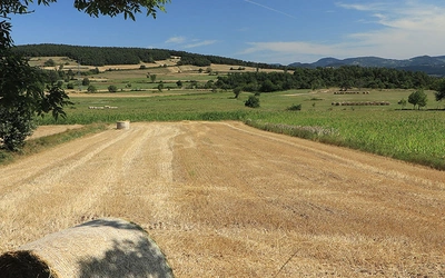
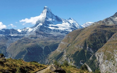
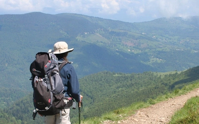
Trekking in the Vanoise is the perfect way to experience some of the finest walking in the Alps. Nestled between Mont Blanc and the Massif des Écrins, the Vanoise National Park dominates the Vanoise Alps massif. Boasting 100-plus peaks above 3000m, it weaves through lush pastures, adorned with lakes, streams, waterfalls, abundant wildlife and vibrant Alpine flowers. The Tour of the Vanoise is ideal as a first Alpine trek, taking less than two weeks to complete. Here's everything you need to know to plan a trip.
Where is the Vanoise?
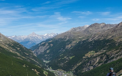
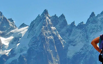
Located in Savoie, between Mont Blanc and the Massif des Écrins, southeast of Chambéry and close to the Italian border, the Vanoise Alps contain more than 100 summits over 3000m. These major peaks are daubed with shrinking glaciers and snowfields and the valleys glisten with lakes, streams and waterfalls. There are towering moraine walls, impossibly steep rock slabs and, in the early summer, meadows extravagant with a riot of Alpine flowers. There’s a wonderland of marked trails to explore, scenic cols to cross, a variety of mountain huts in which to spend the night and abundant wildlife to enrich each day.
While tourist development – especially downhill skiing – has been encouraged on the park’s periphery, the central zone is protected from outside exploitation, and, despite a small number of summer farms, there’s no permanent habitation. As a result, the park boasts an abundance of wildlife and some of the most spectacular displays of Alpine flowers in all Europe.
The Tour of the Vanoise is ideal for a first time trek, as there are plenty of mountain refuges, each spaced around 4 hours walking away, whereas more experienced and energetic trekkers can select longer stages. The Tour des Glaciers de la Vanoise is a shorter but more challenging route which takes in some more difficult passes and exposed, steep paths.
The Cicerone guidebook covers the Tour of the Vanoise, a 150km hut-to-hut trek in the French mountains between Mont Blanc and the Ecrins, described in 11 day stages from Modane. Also included are the 4-day Tour of the Eastern Vanoise, the 3-day Tour of the Western Vanoise and a linear route, a 5-day traverse of the region via sections of the GR5 and GR55 long-distance routes.
Trekking in the Vanoise
Tour of the Vanoise and the Tour des Glaciers de la Vanoise
£18.95
A guide to the Tour of the Vanoise, a 150km hut-to-hut trek in the French mountains between Mont Blanc and the Ecrins, described in 11 day stages from Modane. Also included are the Tour des Glaciers de la Vanoise together with suggestions for other multi-day treks in the national park.
More informationHow long is the route?
The Tour of the Vanoise makes a figure of eight trek in and around the very best of the Vanoise National Park, combining sections of the GR5 and GR55. The Tour described covers a total distance of more than 160km through a series of dramatic wild landscapes, with several high passes over 2500m and a total ascent of around 8200m. While there are some more challenging stages, each has its rewards. The suggested stages in the Cicerone guidebook range from 14km to nearly 20km spread over 11 days.
How challenging is it?
To follow the entire route no technical skills are needed. However, there are a few very brief exposed sections – usually safeguarded by a fixed cable handrail – that could be unnerving for those unused to precipitous slopes, and in such instances extra caution may be required. Under normal summer conditions the trails should be clear of snow and ice, but sometimes unbridged streams flow across them where you’ll need to find a way to cross, either by use of semi-submerged rocks or by simply wading through. Since most of the tour has adopted lengthy sections of both the GR5 and GR55, the paths and waymarking is generally of a good standard.
When should I go?
The region usually receives plenty of snow during the winter, so the best time to tackle the trek is likely to be from mid-June if it has been a mild winter, or the beginning of July. Even then some of the cols and north- or east-facing slopes can be difficult or blocked. The first two weeks of July in a ‘normal’ season will see Alpine flowers at their best, forming one of the highlights of the Vanoise district. Huts are likely to be busy during French holidays from mid-July to mid-August, when accommodation may be difficult to find unless pre-booked. August can also be very warm. September offers perhaps the most favourable conditions.
How should I prepare?
As with all trekking holidays, it’s advisable to build your stamina for walking uphill with a loaded pack before arriving in the Alps. Try to get to a point of having at least walked for a couple of long weekends before your trip to ensure that your first day is as enjoyable and free from aches and pains as your next.
What should I take?
The general recommendation is to ensure that your pack is as light as possible. As camping is prohibited in the National Park except in designated campsites, you will probably opt for hut-to-hut touring, although for a small fee, an overnight pitch is allowed between 1 June and 30 September from 7pm to 8am in designated areas near most of the refuges. Check ‘discoveries’ on the national park website. Apart from ensuring that your boots are comfortable, you will need waterproofs (as thunderstorms and occasional rainy or even snowy days are quite likely), and a fleece for cooler evenings especially in the shoulder seasons. You should also be prepared for extremes of sunshine and heat, so layers work best, and options for shorts as well as trousers are useful. Always ensure you carry plenty of water and sun cream in the summer months.
What accommodation is available?
Most of the accommodation will be in mountain refuges which are usually manned by a gradian from early/mid-June until late September. You will need a sheet sleeping liner, but blankets or duvets are provided. Evening meals invariably consist of three or more courses; soup and bread, simple meat course served with potatoes, rice or pasta is often followed by a green salad, then cheese or a choice of dessert. Vegetarians are catered for if requested when booking in. Vegans may face limited choices of food. Wine, beer and soft drinks are usually available. Breakfasts are ‘continental style’ – plenty of bread and jam (sometimes cheese) and in some cases cereals are also on offer.
What about transport to and from the trail?
The main starting point for this trek is Modane, although the Val d’Isere and Pralognan-la-Vanoise are also possible. Possibly the fastest approach from the UK is via the Eurostar from London to Paris, then the TGV from Paris to Turin, which stops at Modane. Other flight, rail and bus services can be explored.

Pastou
It’s quite possible that you will see one or more large white Pyrenean mountain dogs guarding a flock of sheep. Having been born and raised in the sheepfold, these pastous will have developed a strong bond with the animals they’ve been trained to look after, and will be alert to any perceived danger.
Keep your distance!
If you come across a flock of sheep, make a detour around the grazing area to avoid raising the attention of the pastou. Should one of the dogs approach, it may bark at you, but more likely will simply sniff you and, once satisfied that you present no threat, go back to the flock. Don’t attempt to fuss the dog, keep trekking poles close and as inconspicuous as possible. When the dog has calmed down, turn slowly away.
Overview of the Tour of the Vanoise
Stage 1 Modane to Refuge de l’Orgère
Distance: 6km
Ascent: 890m
Time: 3hrs
This initial stage may be a short one, but it will be quite enough if you have just completed a day’s travel, as the forest trail which climbs out of the valley to Orgère can seem unrelentingly steep. However, it’s a very pleasant stage, with light, spacious forest giving shade on a hot summer’s day, and occasional open meadows bright with flowers.
Stage 2 Refuge de l’Orgère to Refuge de Plan Sec
Distance: 13km
Ascent: 870m
Time: 5hr
The route traces the national park’s boundary on the GR5, for much of the way along a balcony cutting across slopes high above the Maurienne. It goes through forest and over steeply sloping pastures, with a panorama of big mountains walling the south and east sides of the valley, and then makes a loop round a large combe containing a pair of small dammed lakes.
Stage 3 Refuge de Plan Sec to Refuge de l’Arpont
Distance: 16km
Ascent: 750m
Time: 5hr 30min
On this stage you begin to experience the true nature of this remarkable region. Rounding the southern spur of Pointe de Bellecôte, the trail gains a hint of a wilder and more robust country, a contrast of high crags dashed with snow and ice, and low-lying pastures with forest at mid height. As you draw closer to Refuge de l’Arpont, the hanging glaciers of Belle Place, Mahure and Arpont spill cascades over wayside cliffs. Ibex frequent the meadows and rocky places near the refuge, while marmots may be seen, and heard almost anywhere.
Stage 4 Refuge de l’Arpont to Refuge du Plan du Lac
Distance: 13.5km
Ascent: 730m
Time: 4hr 30min
This stage is one of the great walks of the tour; a horseshoe loop with tremendous views practically every step of the way. The terrain is extremely varied with a good possibility of watching wildlife, a multitude of Alpine flowers, and options of diverting into another valley. The route heads north under the Glaciers de la Vanoise towards Mont Pelve, Pointe de la Réchasse and Pointe Mathews, the south summit of La Grande Casse, before descending steeply to the lovely alp farm-turned-refuge Entre Deux Eaux. A short climb leads to the Refuge Plan du Lac.
Stage 5 Refuge du Plan du Lac to Refuge du Vallonbrun
Distance: 18.5km
Ascent: 720m
Time: 6hr 30min
This is a scenically interesting stage, beginning with classic views across the Doron’s gorge to the Glaciers de la Vanoise, with high mountain reflections in a lake. A panorama to the west includes much of the route wandered two days ago, then a view south looks across the Haute-Maurienne to Col du Mont Cenis. In early summer this stage will be one of the very finest in terms of mountain flowers. Once the Crête de la Turra has been turned, the (GR5) trail descends steeply into forest then rises to the unmanned Refuge du Cuchet and continues beyond it on a belvedere of a trail leading to the charming Vallonbrun refuge.
Stage 6 Refuge du Vallonbrun to Bonneval-sur-Arc
Distance: 16km
Ascent: 180m
Time: 4hr 30min
For the first time since setting out from Modane, the route now revisits the valley of the Arc giving an opportunity to restock with supplies. Temporarily deserting the high country, the valley walk from Col de la Madeleine to Bonneval-sur-Arc, along what is known as the Chemin du Petit Bonheur, is easy and enjoyable. The route passes through the hamlet of Le Villaron, and ends in the finest of all Maurienne villages, Bonneval.
Stage 7 Bonneval-sur-Arc to Val d’Isère
Distance: 14.5km
Ascent: 980m
Time: 5hr 30min
The crossing of Col de l’Iseran marks a transition from the Maurienne to the Tarentaise. South of the col, the Arc river drains clockwise round the Vanoise, while north of the Iseran all streams flow into the Isère, a major tributary of the Rhône. From the summit of Col de l’Iseran to Val d’Isère, and beyond through Tignes le Lac and Val Claret, the winter ski industry is much in evidence. Happily, this stage is not entirely dominated by the ski industry, as the first half of the route goes through the Vallon de la Lenta, a delight of gentle pastures, stone chalets, clear-running streams, a booming cascade – and magnificent views back to the south.
An alternative for this and the next stage rises to The Col des Fours at 2976m and descends to Refuge de la Femma, then on to Pralognan-la-Vanoise – part of the more demanding, but shorter Tour of the Glaciers de la Vanoise.
Stage 8 Val d’Isère to Refuge de la Leisse
Distance: 18.5km
Ascent: 1190m
Time: 7hr
This is another stage divided into two distinct parts. The morning will be spent in view either of major ski resorts or of their mechanical accoutrements (or both), while the second half leads into a more remote, natural landscape. From Val d’Isère, the way climbs to gain the 2267m Pas de la Tovière, from where it is possible to see Mont Blanc in the distance. Descent is then made to the ski resorts of Tignes le Lac and Val Claret, although there are alternatives to avoid these resorts. Either way, the trail soon works a way into an untamed land of big mountains, the highest of which is La Grande Motte, whose snowfields and glaciers shine like mirrors in the sunlight. Crossing Col de la Leisse, a descent past moody tarns, screes and boulderscapes loud with the call of marmots leads to Refuge de la Leisse.
Stage 9 Refuge de la Leisse to Pralognan-la-Vanoise
Distance: 18km
Ascent: 450m
Time: 6hr
The crossing of the Col de la Vanoise to Pralognan is a classic stage, passing as it does from a sense of remoteness experienced at La Leisse, via the close proximity of high mountains on the col itself, to the comforts of a low-key resort village hemmed in by lofty peaks. It forms an integral part of the shorter Tour des Glaciers de la Vanoise.
Stage 10 Pralognan-la-Vanoise to Refuge de Péclet-Polset
Distance: 14km
Ascent: 1080m
Time: 5hr
Despite the amount of height gain, this is an undemanding stage mainly on track or tarmac road at a steady gradient, although there are a few steep sections. Beyond the hamlet of Les Prioux the route leads through open countryside, with enticing views to the southwest where the twin aiguilles of Péclet and Polset are daubed with ice.
Stage 11 Refuge de Péclet-Polset to Modane
Distance: 15km
Ascent: 360m
Time: 5hr 30min
Col de Chavière is one of the highest passes crossed by any Grande Randonnée route, but when tackled from Refuge de Péclet-Polset on a fine summer’s day, there are no reasons to feel intimidated by its status. Seen from just above the refuge, the saddle is an obvious one which appears tantalisingly close. Descent to Modane offers a choice of two routes, with the trail dividing about 45min below the col.