Via Ferratas of the Italian Dolomites Volume 2: a complete planning guide
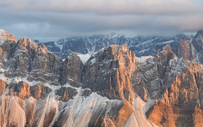
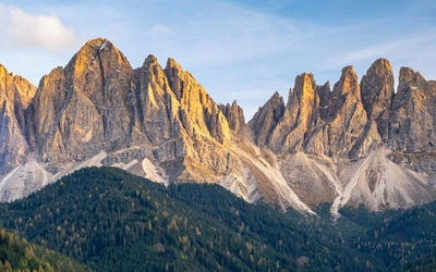
The Dolomites are often cited as the most dramatic and beautiful mountains in the world, and the splendour of the scenery is undeniable. The explosive shapes of the peaks and ridgelines, the ever-changing colours of the rock, the stunning contrast between seasons — these are just some of the factors that make this UNESCO World Heritage range stand apart from its Alpine counterparts. Volume 2 of this definitive Cicerone series covers the southern Dolomites, taking in the Brenta massif, the lake-side crags above Riva del Garda, the Pale di San Martino, Agordino, and Belluno, with 77 via ferrata routes ranging from 1 to 60km and 1 to 12 hours in duration, graded from gentle protected paths to serious high-mountain commitments. (Last updated: June 2026 · Guidebook edition: 2nd edition, May 2026)
Via Ferratas of the Italian Dolomites, quick facts:
- Location: Southern Italian Dolomites, including Brenta, Lake Garda, Pale di San Martino, Agordino, and Belluno
- Total routes: 77 via ferratas and protected paths (sentieri attrezzati)
- Distance range: 1km to 60km per route
- Duration range: 1 hour to 12–14 hours per route
- Difficulty: Grade 1A (easy protected walk) to Grade 5C (serious technical climbing), using the Smith/Fletcher dual system
- Terrain: Exposed ridgelines, cable-protected cliff faces, stemples and ladders, mountain traverses, high plateaus, lake-side crags
- Highest point: Cimon della Pala via Route 54 (Via Ferrata Bolver Lugli), Pale di San Martino
- Navigation: 1:50,000 mapping, colour photo topos, GPS parking coordinates included for every route
- Best season: Mid-June to late September at altitude; routes around Lake Garda and the lower Piccole Dolomiti climbable year-round
- Equipment required: Helmet (UIAA rated), sit harness, via ferrata lanyard with shock absorber
- Accommodation: Rifugi in the mountains, hotels and guesthouses in valley towns, campsites
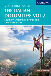
- Guidebook:Via Ferratas of the Italian Dolomites Volume 2 by James Rushforth, 2nd edition, May 2026
Via Ferratas of the Italian Dolomites Volume 2
77 routes in the southern Dolomites – Brenta, Lake Garda, Pale di San Martino
£19.95
Guidebook describing 77 graded via ferrata routes in the Southern Italian Dolomites, a region with explosive shapes and unique colours - the crown jewels of the European alpine range. Routes range from easier protected paths to demanding climbs, covering the southern Dolomites, Brenta and Lake Garda areas.
More information
What is Via Ferratas of the Italian Dolomites Volume 2?
Via Ferratas of the Italian Dolomites Volume 2 is the definitive English-language guidebook to the southern Dolomites, covering 77 graded via ferrata routes across ten geographic areas: Vicenza, Rovereto, Riva del Garda, Brenta, Trento, Bolzano, Feltre, Pale di San Martino, Agordino, and Belluno. It is the companion volume to Via Ferratas of the Italian Dolomites Volume 1, which covers the more famous northern, central, and eastern Dolomites (including Tre Cime, Marmolada, Val di Fassa, Cortina, and Sella). Together the two books form the most comprehensive English-language guide to via ferrata climbing in Italy.
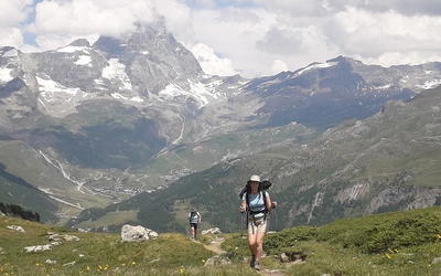
Volume 2 concentrates on areas that tend to attract fewer visitors than the marquee northern resorts, yet offer scenery and climbing of equivalent stature — and in some cases greater variety. The Brenta Dolomites, rising west of the Adige valley, are justifiably famous for their multi-day via ferrata traverse, the Via delle Bocchette, which strings together some of the most spectacular cabled routes in the Alps over three to eight days of hut-to-hut travel. The Pale di San Martino offer an entirely different character: a vast, eerie high plateau ringed by soaring towers, home to routes ranging from easy plateau walks to the committing Grade 4C ascent of the Cimon della Pala (Route 54, Via Ferrata Bolver Lugli). Lake Garda, at the southern end of the guide's coverage, introduces a completely different scale and climate, with lower-altitude crags climbable almost year-round.
One practical advantage of this volume over Volume 1 is that many of its routes develop at lower altitudes, particularly around Lake Garda and the Piccole Dolomiti, making them accessible outside the standard June to September mountain season. This opens the guide to spring and autumn visits that would be restricted by snow on the higher northern routes.
This planning guide answers the most common questions climbers have before setting out on these routes. For complete route descriptions, photo topos, and full mapping, see the Cicerone Via Ferratas of the Italian Dolomites Volume 2 guidebook.
What is a via ferrata, and do I need experience to do one?
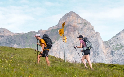
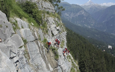
A via ferrata (literally "iron way") is a mountain route protected by a series of fixed steel cables, metal stemples (rungs), pegs, and ladders bolted to the rock. The cables allow climbers to progress through terrain that would otherwise require full rock climbing technique, by clipping a specialised via ferrata lanyard to the wire as they climb. This makes dramatic mountain routes accessible to anyone with a reasonable level of fitness, a head for heights, and the right equipment.
You do not need a climbing qualification or prior rock climbing experience to tackle a via ferrata. No guide is required on Italian routes, and there is no permit system. What the routes do have in common is exposure: even the easiest Grade 1 routes involve a significant drop on one side, and the sensation of height is present throughout. If that does not trouble you, most enthusiastic hillwalkers can make a start on the easier grades.
The standard equipment required for every route in this guide is: a UIAA-rated helmet, a climbing harness, and a via ferrata lanyard incorporating a shock-absorbing system. Via ferrata sets are available to rent at many resorts in the Dolomites if you do not wish to purchase your own. The cables and stemples across the Dolomites are regularly inspected and maintained by the Italian Alpine Club (CAI), which manages nearly 500 rifugios and thousands of kilometres of via ferratas and paths across the region.
How is the guide structured? The 10 areas at a glance
The 77 routes are organised into ten geographic chapters, broadly corresponding to the main valley centres and massifs of the southern Dolomites.
| Area | Routes | Grades available | Character |
|---|---|---|---|
| 1 Vicenza | 5 (Routes 1–5) | 2B–5A | Cima Carega and Monte Gramolon; less-visited, some serious mountain terrain |
| 2 Rovereto | 7 (Routes 6–12) | 1A–4B | Monte Baldo and Piccole Dolomiti; lower altitude, some accessible year-round |
| 3 Riva del Garda | 12 (Routes 13–24) | 1A–5C | Lake Garda crags; diverse, family-friendly to very serious; climbable year-round |
| 4 Brenta | 15 (Routes 25–39) | 1A–4C | Multi-day Bocchette traverse; hut-to-hut; Dolomites' most famous via ferrata area |
| 5 Trento | 7 (Routes 40–46) | 1A–5B | Adige valley and Rotaliana; accessible from Trento, varied terrain |
| 6 Bolzano | 3 (Routes 47–49) | 2A–2C | Monte Roen, Latemar; quieter, scenic, lower commitment |
| 7 Feltre | 4 (Routes 50–53) | 2A–3B | Monte Grappa and Cima d'Asta; long mountain days, wilder terrain |
| 8 Pale di San Martino | 11 (Routes 54–64) | 1A–4C | Dramatic plateau and towers; some of the guide's most committing routes |
| 9 Agordino | 7 (Routes 65–71) | 2C–5C | Civetta massif and Monte Agner; serious high-mountain routes, very remote |
| 10 Belluno | 6 (Routes 72–77) | 3B–4B | La Schiara; remote limestone ridges; also includes the unique Vajont gorge ferrata |

Who is this guide suitable for, and how difficult are the routes?
Via Ferratas of the Italian Dolomites Volume 2 is suitable for anyone from confident hillwalkers attempting their first via ferrata to experienced climbers looking for sustained technical challenges at altitude. The breadth of the route selection is one of the guide's strengths: the 77 routes span every level of the Smith/Fletcher dual grading system, from Grade 1A (a path with a wire and an exposed drop to one side) to Grade 5C (difficult climbing moves, sustained ground, remote and committing terrain).
For first-timers, authors recommend starting with the lower grades. A Grade 1A or Grade 2A route offers the sensation of the via ferrata environment without the technical or physical demands of the harder climbs. Good entry points in this guide include Route 8 (Sentiero Attrezzato delle Vipere, Grade 1A, 8km, 2hr), Route 20 (Via Ferrata Colodri, Grade 2A, 5km, 2hr) near Arco, and Route 17 (Via Ferrata Mario Foletti, Grade 1A, 7km, 4hr) above Lake Garda — all in the Riva del Garda chapter and accessible from valley-level towns.
At the other end of the scale, the Agordino chapter contains some of the most demanding routes in the guide. Route 70 (Via Ferrata Gianni Costantini on Cima Moiazza Sud) carries a Grade 5C rating with 1500m of wire, a 20hr round trip, and an overnight at Rifugio Carestiato recommended. Route 65 (Via Ferrata Stella Alpina on Monte Agner) is similarly graded 5C with a 10–12hr day. These are serious high-mountain undertakings for experienced ferratisti only.
The dual grading system is key to understanding the routes in this guide. The numeric grade (1–5) rates technical difficulty; the letter grade (A–C) rates seriousness, defined as the commitment of the mountain environment, the distance to help, and the possibility of escape if conditions change. A route graded 3C may not be technically hard but could present major logistical problems in the event of an accident or weather change. Both grades should be read together before committing to a route.

What is the Brenta Bocchette traverse?
The Brenta Dolomites are the standout area of this volume and home to the most celebrated multi-day via ferrata traverse in the Alps. The Via delle Bocchette links a series of high routes across the Brenta massif, connecting mountain huts (rifugi) by cabled traverses, ladders, and airy bridges across the face of the rock. The traverse can be completed in as few as three days or extended to a week or more depending on the combination of routes chosen.
Routes 30 to 36 in the Brenta chapter cover the core of the traverse, from Via Ferrata Alfredo Benini (Grade 2C) and Via Ferrata Bocchette Alte (Grade 4C, 400m of wire) through to Via Ferrata Bocchette Centrali (Grade 3C, 500m of wire) and Via Ferrata Livio Brentari (Grade 3C). These are serious mountain routes that develop at altitude and include sections of genuinely technical climbing. The key huts for the traverse are Rifugio Tuckett e Sella, Rifugio Alimonta, and Rifugio Tommaso Pedrotti; these must be booked well in advance, often six to nine months ahead for the peak summer period.
The Brenta is also one of the few areas in the guide where the full circuit lends itself to careful stage splitting, with easier access via the Cabinovia Grost gondola from Madonna di Campiglio reducing the approach for several routes and making a range of single-day options viable.
When is the best time to climb via ferratas in the southern Dolomites?
The best time for most routes in this guide is June to late September, with some nuance by area and altitude.
- June: Snow can linger on high-altitude routes, particularly those in the Brenta and Pale di San Martino above 2500m. The lower routes around Lake Garda and the Piccole Dolomiti (Vicenza, Rovereto chapters) are generally clear and uncrowded. Weather tends to be more stable than July and August.
- July and August: Peak season. The Dolomites are busy, routes above popular resorts can be crowded, and accommodation is more expensive and harder to find. Afternoon thunderstorms are common from around 2pm; an early start is essential. Despite the crowds, many routes in the Belluno, Agordino, and Feltre chapters remain quiet.
- September: Often the most stable weather of the season, with clearer skies and fewer afternoon storms. The crowds thin out significantly after the first week. An excellent time for the harder Agordino and Pale di San Martino routes. Later in the month, temperatures drop at altitude and the first dusting of snow is possible on the highest tops.
- October: The autumn colours in the larch forests are spectacular, but the tourist infrastructure closes, many rifugi shut, and high routes drop out of condition. Lower routes around Lake Garda may still be climbable with care.
- Winter: Via ferratas in the Dolomites should not be attempted in winter without crampons, ice axes, and full mountaineering experience. The cables themselves freeze and the stemples ice over; conditions are completely different from the summer experience.
- Year-round: Routes in the Lake Garda, Riva del Garda, and Piccole Dolomiti areas (particularly Chapters 1–3) develop at lower altitudes and are climbable outside the standard mountain season, though south-facing routes can be uncomfortably hot in high summer.

What accommodation is available on these routes?
Accommodation in the Dolomites is plentiful at every price point, from basic campsites and campervan stellplatz to polished rifugi and valley hotels.
Rifugi are the accommodation of choice for routes at altitude and for multi-day traverses such as the Brenta Bocchette. Despite the name (literally "refuge"), many Dolomite rifugi operate more like small alpine hotels, with private rooms or dorm bunks, a substantial breakfast, and a three-course evening meal. Half-board (mezza pensione) is standard. Bring a sleeping bag liner if using dorm bunks. Rifugi on popular routes — particularly in the Brenta — must be booked many months in advance, often six to nine months ahead for July and August. This is not an exaggeration: the most sought-after huts fill very quickly after they open for reservations.
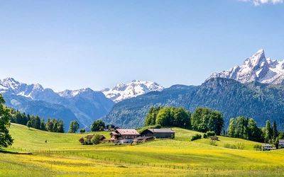
Valley accommodation is well developed throughout the guide's coverage areas. The main centres — Arco, Riva del Garda, Madonna di Campiglio, Molveno, Trento, San Martino di Castrozza, Agordo, Belluno, and Bolzano — all offer a wide choice of hotels, garnì (bed and breakfasts), and self-catering apartments. August is the most expensive and elusive period; booking ahead is strongly advised.
Camping is available at a number of sites around the region, many of which have developed into well-equipped (and no longer especially cheap) sites. Campervan travellers can use area attrezzata or stellplatz car parks, which charge a modest fee and often provide running water and waste disposal.
For a full listing of rifugi, hotels, and contacts by area, see Appendix A of the guidebook.
How do I get to the southern Dolomites?
The southern Dolomites are accessible from several international airports, all within approximately 2hr 40min to 3hr 50min driving distance. Hiring a car is strongly recommended; while public transport exists in the main valleys, many of the trailheads in this guide are difficult or impossible to reach by bus.
The closest airports by driving time are:
- Treviso: approx. 2hr 40min
- Venice (Marco Polo): approx. 2hr 40min
- Verona: approx. 2hr 50min
- Munich: approx. 3hr 40min
- Bergamo: approx. 3hr 50min
If bringing your own vehicle from the UK, the fastest route is via France through Calais (allow 12–14 hours). A slightly longer but more economical alternative routes through Belgium, Germany, and Austria. Austrian motorways require a Vignette (available at petrol stations, valid for 10 days, 2 months, or 1 year). The Brenner Pass carries a separate fixed toll of approximately €12. Italian motorways are tolled.
Public transport options include regular train services from Venice to Belluno, from Innsbruck to Bolzano, and from Verona to Trento. From these hubs, regional bus services reach many of the valley bases: Trentino Trasporti serves Rovereto, Riva del Garda, and the Pale areas; Dolomitibus covers Belluno, Feltre, and Cortina; ATV Verona connects Verona airport to the Lake Garda shore towns. Services into the higher valleys typically operate between June and September only.
Some routes involve mountain traverses with a start and finish at different points; in these cases a bus can be the most practical way to return to your car. Timetables for all regional operators are listed in Appendix A of the guidebook.
What maps do I need for the southern Dolomites?
The guidebook recommends Tabacco maps at 1:25,000 for navigation, with the relevant map number listed in each route information box. Every route also includes a 1:50,000 overview map and, where the route is particularly complex, an annotated colour photo topo.
The ten geographic chapters in this guide correspond to the following Tabacco map sheets:
- Vicenza/Rovereto: Tabacco 055, 056, 059, 063
- Riva del Garda: Tabacco 055, 071, 078
- Brenta: Tabacco 053
- Trento: Tabacco 049, 055, 057, 067
- Bolzano: Tabacco 014, 029, 049
- Feltre: Tabacco 051, 058
- Pale di San Martino: Tabacco 022
- Agordino: Tabacco 015
- Belluno: Tabacco 021, 024
Tabacco maps are available online from suppliers such as Stanfords and Amazon before your trip, and locally at newsagents, gift shops, and supermarkets throughout the region. Both Tabacco and Kompass now offer mobile mapping apps; the guidebook recommends using these in conjunction with a paper map rather than as a standalone navigation tool. The free Mapy.com app, with offline maps downloaded before you head out, is highlighted as a useful supplementary resource.
GPS coordinates for the recommended parking location are included in every route information box.
Volume 1 versus Volume 2: which guide do I need?
The two volumes together cover the complete Italian Dolomites via ferrata network, but they focus on distinct geographic areas with different characters.
Via Ferratas of the Italian Dolomites Volume 1 covers the northern, central, and eastern Dolomites, including the most famous and heavily visited areas: Tre Cime di Lavaredo, Marmolada, the Sella group, Catinaccio, Val di Fassa, Cortina d'Ampezzo, and Corvara. These are the routes that dominate social media and attract the highest visitor numbers, particularly in July and August. If your priority is the iconic, postcard Dolomites scenery and you are happy sharing the routes with others, Volume 1 is the natural starting point.
Volume 2 covers the southern Dolomites, including Brenta, Lake Garda, Pale di San Martino, Agordino, and Belluno. These areas are generally less crowded, offer more variety in altitude and season (particularly the year-round Lake Garda routes), and include some routes that see very few visitors even at the height of summer. The Brenta Bocchette is the exception — it is one of the most celebrated multi-day via ferrata traverses in the Alps — but elsewhere in Volume 2, solitude and mountain tranquillity remain genuinely achievable. If you are returning to the Dolomites for a second or third trip, or specifically want to explore off the beaten track, Volume 2 is the essential companion.
Many visitors buy both volumes. The two books were originally written by John Smith and Graham Fletcher and have been revised and updated to their current editions by James Rushforth, ensuring a consistent approach to grading, description, and practical information across the complete set.
Plan your via ferrata adventure with the Cicerone guidebook
Via Ferratas of the Italian Dolomites Volume 2 by James Rushforth contains everything you need to plan and complete all 77 routes across the southern Dolomites, Brenta, and Lake Garda. The guidebook includes:
- Full route descriptions for all 77 via ferratas and sentieri attrezzati across 10 geographic chapters, with start and finish points, distance, estimated time, total ascent and descent, and practical notes for each
- A route summary table covering all 77 routes at a glance, with grade, wire length, and GPS parking coordinates for every trailhead
- The widely adopted Smith/Fletcher dual grading system, rating both the technical difficulty (1–5) and seriousness (A–C) of each route, so you can accurately assess what you are taking on
- 1:50,000 overview maps and colour photo topos for every route, making navigation straightforward even on complex and exposed terrain
- A comprehensive introduction covering equipment (helmets, harnesses, via ferrata lanyards and shock absorbers), cable etiquette, what to wear, and accident and mountain rescue procedures
- Detailed seasonal guidance, weather patterns, and advice on when to go — including which routes are climbable year-round at lower altitude around Lake Garda and the Piccole Dolomiti
- Accommodation listings covering rifugi, hotels, garnì, campsites, and campervan stellplatz by area, with guidance on booking the huts for the Brenta Bocchette traverse (Appendix A)
- Transport and access information for all trailheads, including driving times from nearby airports, regional bus operators, and lift systems, plus advice on making the most of public transport for linear routes
- Recommendations for Tabacco 1:25,000 mapping, with the relevant map sheet number listed for every route in the guide
- GPX files for the routes, downloadable from your Cicerone account
- Appendices covering useful contacts, a glossary of mountain terms, and further reading
Available as a printed guidebook to Via Ferratas of the Italian Dolomites Volume 2 (£19.95) or digital eBook (£19.95). Published: 7 May 2026.
Via Ferratas of the Italian Dolomites Volume 2
77 routes in the southern Dolomites – Brenta, Lake Garda, Pale di San Martino
£19.95
Guidebook describing 77 graded via ferrata routes in the Southern Italian Dolomites, a region with explosive shapes and unique colours - the crown jewels of the European alpine range. Routes range from easier protected paths to demanding climbs, covering the southern Dolomites, Brenta and Lake Garda areas.
More informationAbout James Rushforth, guidebook author:
James Rushforth has authored guidebooks on rock climbing, ski mountaineering, via ferrata, travel and photography. His work has won Travel Guidebook of the Year at the Best Indie Book Awards, the British Guild of Travel Writers, the Outdoor Writers and Photographers Guild, and the Foreword INDIES. When not writing, James leads photography workshops to the Arctic, Greenland, Iceland, the Faroe Islands, Norway, Italy and the Himalayas.
His work frequently appears in guidebooks, publications and magazines around the world, including The Guardian, The Telegraph, the Daily Express, the Daily Star and The Independent newspapers. He has been interviewed on the BBC and his images have been exhibited at high-profile venues including the National Maritime Museum. On social media, he is part of the National Geographic Your Shot photography team.
A member of the British Guild of Travel Writers, James is also a Breakthrough Photography, Wilkinson Cameras & f-stop ambassador, is part of the Norrøna Pro Team, and is kindly supported by Hilleberg. For more information on James' work, his public speaking and photography workshops, or to get in touch, he can be contacted at jamesrushforth.com.