Alta Via 2 Dolomites: a complete planning guide
The Alta Via 2 is a 174km (108-mile) high-level trekking route through the Italian Dolomites, running from Bressanone in the north to Feltre in the south. Completed in 13 stages over approximately two weeks, it is a challenging and technically demanding route with exposed sections and aided stretches. The route is the natural progression for trekkers who have already completed the Alta Via 1 and a hugely rewarding destination for experienced alpine walkers tackling the Dolomites for the first time. (Last updated: March 2026 · Guidebook edition: 5th edition, first published 2022, reprinted 2025)
Alta Via 2 quick facts:
- Distance: 174km / 108 miles
- Duration: 13 stages, approximately two weeks
- Start: Bressanone (Brixen), northern Dolomites
- Finish: Feltre, southern Dolomites
- Stages: 13
- High point: 2907m
- Difficulty: Grade 2–3 (challenging, with exposed and aided sections)
- Waymarking: '2' in a red triangle
- Accommodation: Rifugi (mountain huts) throughout, with occasional hotels and bivouac huts
- Best season: Mid June to late September
- Also in this guidebook: Alte Vie 3, 4, 5 and 6 described in outline
- Guidebook: Alta Via 2 — Trekking in the Dolomites by Gillian Price, 5th edition (2022, reprinted 2025)
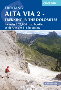
Alta Via 2 - Trekking in the Dolomites
Includes 1:25,000 map booklet. With Alte Vie 3-6 in outline
£18.95
Guidebook to the Alta Via 2 through the Italian Dolomites. Suitable for experienced hikers with a head for heights, the challenging but hugely rewarding hut-to-hut trail covers 160km in 13 days and involves steep and technical terrain and exposed sections. The more demanding AV3-6 routes are described in outline. Includes 1:25K map booklet for AV2.
More information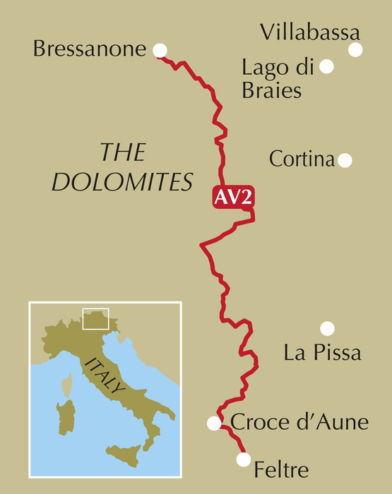
What is the Alta Via 2?
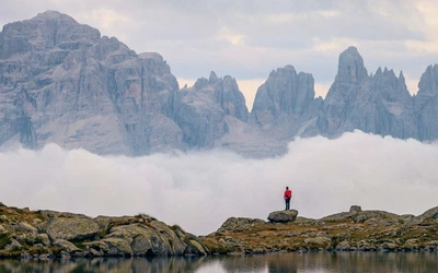
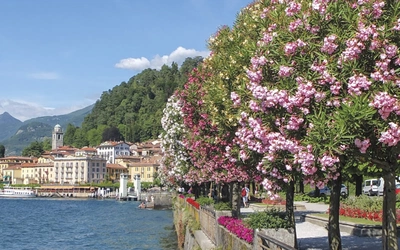
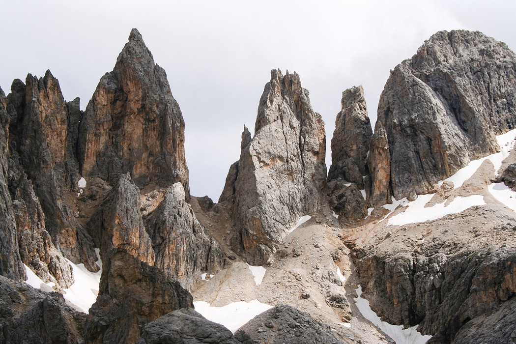
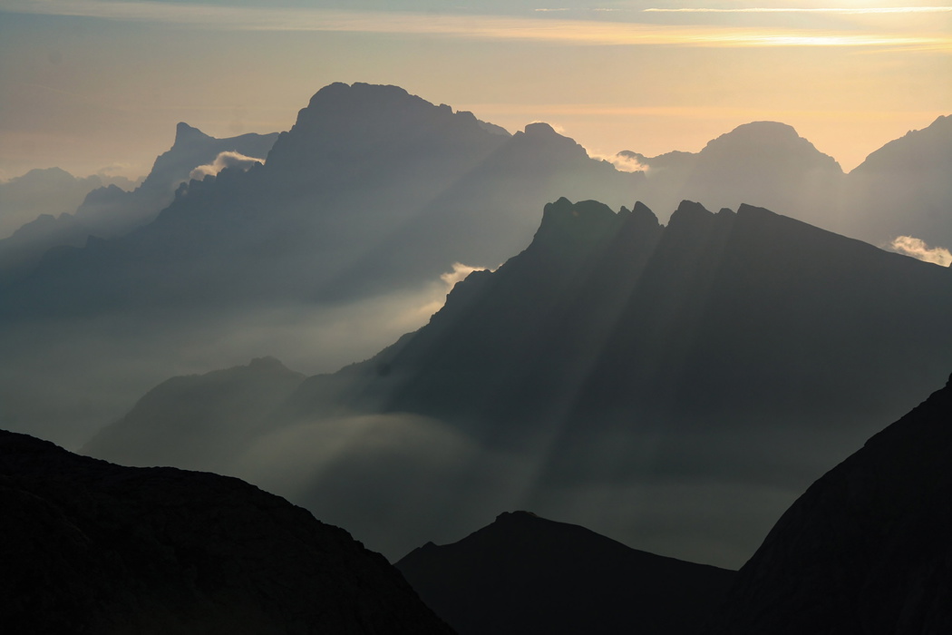
Dubbed the Alta Via delle Leggende (the High Way of Legends), the Alta Via 2 is the most challenging and dramatic of the Dolomites alta via routes regularly walked by experienced trekkers. Stretching 174km from the baroque town of Bressanone in the northwest to Renaissance-style Feltre in the far south, it traverses some of the most spectacular mountain groups in the UNESCO World Heritage Dolomites: the Plose massif, the jagged Puez-Odle and its vast plateau, the forbidding fortress-like Sella, the majestic Marmolada (the highest mountain in the Dolomites at 3342m), the spectacular Pale di San Martino and the rugged Alpi Feltrine.
Unlike the Alta Via 1, which is straightforward and suitable for first-time alpine trekkers, the AV2 entails aided and exposed sections requiring a head for heights, experience on steep mountain terrain and confidence navigating in high-altitude conditions. Several of the technical sections can be detoured, but the route is fundamentally more demanding than its companion trail.
One practical advantage distinguishes the AV2 from many other long-distance treks: you walk out of Bressanone railway station at the start and finish at Feltre railway station at the end. No shuttle, no car, no logistical complexity at either end.
The Cicerone AV2 guidebook also includes outline descriptions of Alte Vie 3, 4, 5 and 6 (the four more remote and technically demanding alta via routes through the Dolomites) making it the only single volume covering all five of these routes.
This planning guide answers the most common questions trekkers have before setting out. For complete stage-by-stage route descriptions, 1:25,000 mapping and accommodation listings, see the Cicerone Alta Via 2 guidebook.
How does the Alta Via 2 compare to the Alta Via 1?
The two routes are natural companions but serve different audiences:
- Alta Via 1 is 115km across 11 stages, rated Grade 2 overall, and is explicitly suitable for first-time alpine trekkers. It is well-trodden, straightforward to follow, and has only one short section with cable-aided stretches (avoidable via a variant).
- Alta Via 2 is 174km across 13 stages, rated Grade 2–3 overall, and requires a head for heights and experience on steep, exposed mountain terrain. It involves multiple aided sections across several stages, visits higher and more technically demanding ground, reaching 2907m, and passes through wilder, more remote mountain groups including the Puez-Odle, the Sella and the Pale di San Martino.
The two routes are frequently walked as a pair over successive seasons. The AV1 makes an ideal introduction to Dolomites hut-to-hut trekking; the AV2 is the logical next step for walkers who want more elevation, more challenge and more varied terrain.
How long is the Alta Via 2?
The Alta Via 2 covers 174km across 13 stages, with a total ascent of 11,650m and descent of 11,740m. The figures per stage give a clear picture of the daily commitment involved.
| Stage | Distance | Time | Ascent/Descent |
|---|---|---|---|
| Bressanone to Rifugio Plose | 12km | 5hr 45min | 1910m/20m |
| Rifugio Plose to Rifugio Genova | 13.5km | 4hr | 680m/530m |
| Rifugio Genova to Rifugio Puez | 12km | 5hr | 840m/660m |
| Rifugio Puez to Rifugio Pisciadù | 10km | 5hr | 900m/800m |
| Rifugio Pisciadù to Rifugio Castiglioni | 16km | 6hr 30min | 690m/1230m |
| Rifugio Castiglioni to Passo San Pellegrino | 22km | 7hr | 1110m/1240m |
| Passo San Pellegrino to Rifugio Mulaz | 13km | 5hr 30min | 1040m/380m |
| Rifugio Mulaz to Rifugio Rosetta | 7.5km | 4hr 15min | 750m/740m |
| Rifugio Rosetta to Rifugio Treviso | 13km | 6hr 15min | 790m/1740m |
| Rifugio Treviso to Passo Cereda | 8.5km | 4hr 30min | 750m/1010m |
| Passo Cereda to Rifugio Boz | 13.5km | 7hr | 1250m/900m |
| Rifugio Boz to Rifugio Dal Piaz | 14km | 6hr | 940m/670m |
| Rifugio Dal Piaz to Feltre | 19km | 4hr 30min | negligible/1820m |
| Total | 174km | 71hr 15min | 11,650m/11,740m |
Stage 1 stands out: 1910m of ascent in 12km makes the opening day the most physically demanding single climb of the entire route. Stage 8 (rated 3+) is the most technically difficult. Stage 6, at 22km, is the longest day.
Who is the Alta Via 2 suitable for?
The AV2 is described in the guidebook as the perfect first Dolomites trek for experienced walkers, or the natural second trek after completing the AV1. It is not suitable for beginners.
Walkers need to be:
- Experienced on steep, rocky, high-altitude mountain terrain
- Confident with a head for heights, as multiple stages involve exposed sections
- Comfortable navigating in poor visibility on high-altitude terrain
- Physically fit for sustained daily ascents and descents, sometimes exceeding 1,000m each way
- Prepared to carry a short rope and karabiner clips for aided sections (not compulsory but recommended for less confident walkers)
Those uncertain about the technical sections should note that several can be detoured via alternative paths. However, detours add distance and time, and the route's character is fundamentally more demanding than the AV1.
How difficult is the Alta Via 2?
The AV2 rates Grade 2–3 overall, more challenging than the AV1's Grade 2. Individual stages vary from Grade 2 (demanding but non-technical) to Grade 3+ (requiring experience on exposed mountainous terrain and a head for heights).
Key challenges specific to the AV2:
- Aided sections appear across multiple stages (3, 4, 5, 7, 8, 9, 11 and 12). These are not full via ferrata routes — full harness and helmet are not required — but a short rope and karabiners are helpful. Less confident walkers may prefer carrying a waist sling and karabiners for reassurance on the most exposed stretches.
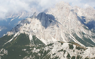
- Stage 8 (Rifugio Mulaz to Rifugio Rosetta, rated 3+) is the most technically demanding stage on the route. The high-altitude crossing of the Altipiano delle Pale di San Martino involves genuine exposure.
- Stage 1 involves 1910m of ascent in a single day, a significant physical commitment on the opening day of a two-week trek.
- Snow can linger on the Sella and the Altipiano di San Martino into early summer. If planning in mid-June, check conditions with the relevant rifugi before setting out.
For those wanting to go further, the four Alte Vie 3–6, summarised in the Cicerone guidebook, are even more demanding. They feature longer, more technical-aid sections, remote terrain with fewer manned huts, and require trekkers to carry food and cooking equipment for nights in unmanned bivouac huts. Full via ferrata equipment (helmet, harness, Y-model ferrata kit) is required for AV4, 5 and 6.
Can I walk a shorter section of the Alta Via 2?
Yes. All the suggested start and finish points below are served by buses connecting with railway lines:
- 3 days: Passo Gardena (Stage 4, bus from Bolzano) to Passo San Pellegrino (Stage 6, bus to Trento)
- 4 days: Bressanone (Stage 1, train) to Passo Gardena (Stage 4, bus to Bolzano)
- 4 days: Passo San Pellegrino (Stage 6, bus from Trento or Belluno) to Passo Cereda (Stage 10, bus to Feltre)
- 6 days: Passo Gardena (Stage 4) to Rifugio Pradidali (Stage 9, exit to Fiera di Primiero for bus to Feltre)
- 10 days: Bressanone (Stage 1, train) to Passo Cereda (Stage 10, bus to Feltre)
Exit routes throughout the route description provide options to shorten or escape the route at almost any point, which is essential for emergencies, bad weather, or a change of plan.
Which direction should I walk the Alta Via 2?
The route is described north to south, from Bressanone to Feltre, and this is the recommended direction. Walking northbound is possible, but waymarking is designed for the southward direction and the guidebook's route descriptions would need to be read in reverse.
The north-to-south direction also has the practical advantage of finishing at Feltre railway station, from which trains run south to Treviso and Venice, making the journey home straightforward.
When is the best time to walk the Alta Via 2?
The season runs from mid June to late September, when rifugi are open and snow has generally cleared from the high passes and plateaus.
- Mid June to early July: the season opens, but snow may still cover high sections including the Sella and the Altipiano di San Martino. Check conditions with relevant rifugi before committing to the full route
- July: long days and brilliant flowers, often the finest walking conditions.
- August: more people and busier accommodation; path conditions most favourable and snow generally absent.
- September to October: crystal-clear skies, quieter paths, spectacular pre-autumn colours. Huts in the northern Südtirol stay open into October; those in the southern districts typically close in late September.
Afternoon thunderstorms are a regular feature of Italian alpine summers. Set out early each day. Stage 8 in particular, the Pale di San Martino crossing, should not be attempted in poor visibility or threatening weather conditions.
Note on Rifugio Plose (Stage 1): The hut was closed for restructuring in summer 2025. Check current status before finalising your itinerary.
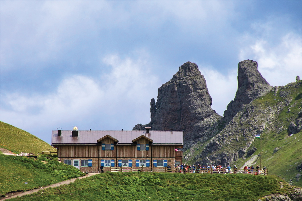
What accommodation is available?
The AV2 is a hut-to-hut trek with each stage designed to conclude at a staffed rifugio providing meals, beds and the essential Dolomites experience of communal dining in a timber-lined stube. Accommodation arrangements broadly mirror those of the AV1, with a few important differences.
Rifugi are the primary accommodation throughout. An average of €55 covers mezza pensione (half board: three-course dinner, overnight stay and breakfast), not including drinks. CAI members and affiliated UIAA club members save at least €10 per night. The single ATM on AV2 is at Passo San Pellegrino (Stage 6), so carry plenty of euros.
Hotels are available at several road passes and villages along the route, providing a welcome break from dormitory life on rest days.
Bivouac huts (unmanned shelters) are used as alternatives on Stages 9 and 11. These provide basic shelter with bunk beds but variable facilities. Carry a sleeping bag, food and a stove when using them. They cannot be booked and can fill on busy midsummer weekends.
Camping: the only campground on AV2 is at Malga Ciapela (Stage 6). Wild camping is not permitted in the three nature parks traversed (Stages 2–4 and 7–13).
Booking: advance reservation is strongly recommended, especially for midsummer weekends. Most rifugi have websites for online booking; hut staff will always phone ahead to the next hut on your behalf.
What is the food like on the Alta Via 2?
Food is one of the genuine pleasures of the AV2, reflecting the remarkable cultural mix of the Dolomites: part Italian, part Austro-Hungarian, with a strong Südtirol character in the northern stages and Veneto flavours in the south.
Dinner typically opens with minestrone or barley soup, followed by pasta with meat or tomato sauce. Specialities include gnocchi di patate con ricotta affumicata (potato dumplings with smoked cheese), casunziei (ravioli with beetroot filling and poppy seeds), and canederli (bread dumplings with speck, served in consommé). Second courses include the flavoursome peppery sausage pastin from the southern Dolomites, and schiz, a fresh local cheese like mozzarella, grilled or pan-fried in butter and cream. Polenta with goulash or melted cheese is common and always filling.
Dessert may be frutti di bosco (wild berries) with cake or ice cream, Apfelstrudel, or Kaiserschmarrn, a sliced pancake with sultanas and jam. Zelten, a rich biscuit crammed with dried fruit, travels well in rucksacks. Local wines are worth seeking out: red Teroldego and Schiava from the Trentino, Lagrein and Blauburgunder from the Bolzano slopes, and aromatic Gewürztraminer among the whites.
Order packed lunch rolls (panini) the evening before. There are no shops along the route except at Malga Ciapela (Stage 6).
What wildlife might I see on the Alta Via 2?
The AV2 traverses three protected nature parks — Puez-Odle, Pale di San Martino and Dolomiti Bellunesi — and the wildlife encountered on the route is among the most diverse of any Dolomites alta via.
Alpine marmots are the most commonly seen animals: sociable, beaver-like creatures that live in underground colonies and post a sentry who emits a piercing warning whistle at the approach of walkers. Chamois, slender mountain goats with crochet-hook horns, are regularly spotted on steep rock faces and scree slopes. Ibex, with their impressively thick grooved horns, were reintroduced to the Dolomites in the 1970s from the Gran Paradiso; large herds are often encountered in the eastern Dolomites along the later stages of the AV2. Brown bears (estimated population 50–60, mostly in the Trentino) and wolves are present but rarely seen.
Birdwatchers should watch for the lammergeier (bearded vulture, 3-metre wingspan), the alpine chough (yellow-beaked crow, guaranteed at any col where walkers stop to eat) and the wallcreeper, which flutters over sheer rock faces flashing its black plumage with red panels.
In the southern Dolomites, vipers are present in wooded areas. They are venomous but attack only under threat, so step back and give them time to move. Ticks are a consideration in wooded sections; wear long trousers and use permethrin repellent on clothing.
What are the route highlights?
The AV2 visits a succession of dramatically different mountain groups across its 174km. Key highlights include:
- The Plose massif (Stages 1–2): the demanding opening ascent of 1910m delivers spectacular views over Bressanone and the Isarco valley, a fitting introduction to the scale of what follows.
- The Puez-Odle (Stages 2–3): the vast, otherworldly plateau of the Puez-Odle nature park, with its distinctive dolomite towers and sweeping views, is one of the finest high-altitude landscapes in the Dolomites.
- The Sella (Stage 4): the fortress-like Sella massif, crossing at 2681m, is one of the most iconic views in the entire range; the aided ascent on Stage 4 is demanding but unforgettable.
- Marmolada (Stage 6): the highest mountain in the Dolomites at 3342m, with its rapidly shrinking glacier and high-altitude WWI fortifications and museum accessible by cable car from Stage 6.
- Passo San Pellegrino (end of Stage 6): the only ATM on the route and the most accessible resupply point, a natural rest-day stop.
- The Pale di San Martino (Stages 7–9): the vast, austere limestone plateau is the most dramatic section of the entire route. Stage 8, rated 3+, is the AV2's defining challenge and its finest moment.
- San Martino di Castrozza (near Stage 9): an optional detour to one of the Dolomites' most picturesque resort villages, with good facilities for a rest day.
- The Alpi Feltrine (Stages 11–13): the quiet, wilder southern stages through the Feltrine mountains see far fewer walkers and offer a more solitary, contemplative conclusion to the trek before the descent into Feltre.
What about Alte Vie 3–6?
The Cicerone AV2 guidebook uniquely includes outline descriptions and route maps for Alte Vie 3, 4, 5 and 6, making it the most comprehensive single source for the Dolomites alta via network.
- Alta Via 3: more demanding and solitary than the AV2, with prolonged aided sections and remote terrain.
- Alta Vie 4, 5 and 6: full-blooded via ferrata routes requiring a helmet, full body harness and Y-model ferrata kit conforming to UIAA standards. Stretches are spent in unmanned bivouac huts. Climbing experience or a qualified guide is essential.
The outline descriptions include diagram route maps showing facilities, transport and difficulty, allowing walkers to plan shorter village-to-village sections that can be detached from the more demanding stretches.
How do I get to the start and back from the finish?
Getting to Bressanone (start): Bressanone has a railway station on the main Brenner Pass line. From northern Europe and the UK, the train route via Eurostar to Paris, TGV to Munich, then via Innsbruck and the Brenner Pass to Bressanone is a practical and less polluting alternative to flying. From Venice or Verona, direct trains run to Bressanone via Trenitalia and Austrian Rail.
- By air to Venice (Marco Polo): local bus to Mestre station, then train via Verona to Bressanone
- By air to Treviso: bus to Treviso station, then train via Verona to Bressanone
- By air to Verona: shuttle to Verona Porta Nuova station, then train north to Bressanone
Getting home from Feltre (finish): Feltre has a railway station with trains to Treviso and Venice. Trentino Trasporti buses run to Trento for rail connections back north to Bressanone if needed. The finish at Feltre, like the start at Bressanone, requires no car and no shuttle.
Train tickets: Stamp paper tickets in the platform machines before boarding — failure to do so can result in a fine.
What should I wear and carry?
The AV2 is hut-to-hut, meaning you can travel lighter than on a wild-camping route. The recommended maximum pack weight is 10% of your body weight plus 2kg.
Key items beyond standard alpine trekking kit:
- Boots with ankle support and non-slip Vibram soles, properly broken in
- Waterproofs: jacket, over-trousers and rucksack cover
- Warm layers including hat and gloves (even in summer; the temperature drops 6°C for every 1000m climbed)
- Sleeping sheet or bag liner (silk is ideal for weight)
- Trekking poles: strongly recommended for steep descents, particularly the 1820m final descent on Stage 13
- Foam ear plugs for dormitory sleeping
- High-factor sun cream (UV intensity increases 10% per 1000m)
- Cash in euros: the only ATM is at Passo San Pellegrino (Stage 6)
- For aided sections: a short rope and karabiner clips are recommended for less confident walkers
- Ice axe and crampons: occasionally needed in early summer if icy hard snow covers the Sella and San Martino plateaus. Check with relevant rifugi before packing
- GPX tracks available free at www.cicerone.co.uk/1097/GPX
Plan your trek with the Cicerone guidebook
The Cicerone Alta Via 2 guidebook, written by Gillian Price and now in its fifth edition (first published 2022, reprinted 2025), provides everything you need to walk the route with confidence:
- Complete stage-by-stage route descriptions for all 13 stages, with distance, time, total ascent/descent and grade for each
- 1:25,000 Kompass mapping in a separate pull-out booklet
- Outline descriptions and route maps for Alte Vie 3, 4, 5 and 6
- Shorter itinerary options for 3, 4, 6 and 10-day sections
- Full rifugio accommodation listings with booking contact details
- Food and drink guide covering Dolomites specialities by region
- Detailed transport guide for all approach and exit options
- Wildlife, geology, plants and flowers sections
- Italian–English glossary and emergency procedures
- Free GPX tracks at www.cicerone.co.uk/1097/GPX
Available as a printed guidebook (£18.95) or digital eBook (£18.95).
Alta Via 2 - Trekking in the Dolomites
Includes 1:25,000 map booklet. With Alte Vie 3-6 in outline
£18.95
Guidebook to the Alta Via 2 through the Italian Dolomites. Suitable for experienced hikers with a head for heights, the challenging but hugely rewarding hut-to-hut trail covers 160km in 13 days and involves steep and technical terrain and exposed sections. The more demanding AV3-6 routes are described in outline. Includes 1:25K map booklet for AV2.
More informationAbout Gillian Price, guidebook author:
Gillian Price has trekked throughout Asia and the Himalayas, but now lives in Venice and is exploring the mountains and flatter bits of Italy. Starting in the Italian Dolomites, Gillian has written outstanding Cicerone guides to walking all over Italy as well as Corsica and Corfu. An adamant promoter of public transport to minimise environmental impact, Gillian belongs to Mountain Wilderness and is an active member of the Venice branch of CAI, the Italian Alpine Club. Find out more at www.gillianprice.eu.