Walking in Jura's geological wonderland

Cicerone author Peter Edwards rarely used to take the time to appreciate the environment around him when out on the hills, but a trip to the Isle of Jura in the Southern Hebrides prompted a change in his attitude.
A happy corollary of a love of walking is that it often nurtures an interest in various aspects of the landscapes encountered during our journeys on foot. Equally, an interest in plants, animals, geology or the physical traces of human history, for example, might itself be a motivation for many walkers in the first instance.
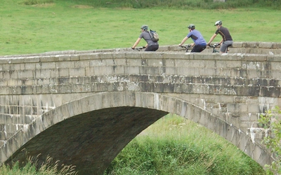
As a younger man and common-or-garden endorphin junkie, my primary focus and motivation as a walker and mountain biker was to get out on the hills and burn up the miles as an exercise in athleticism and endurance. Obviously doing so amid the sublime whale-backed chalk hills of the South Downs or the jagged limestone massifs of the Pyrenees was a definite bonus, but in truth I seldom took time to really appreciate my environment.
‘Un-getatable’ Jura
Perhaps it's something to do with slowing down a bit and changing my priorities when out walking, but I can confidently pin a sea-change in my attitude towards my environment on my first visit to the Isle of Jura in the Southern Hebrides back in 2006.
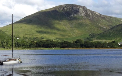
Lying a few miles off the Argyll coast on Scotland's western seaboard, Jura is perhaps best known for its triumvirate of breast-shaped, scree-clad Paps, its eponymous whisky and its most famous temporary resident, George Orwell.
Jura is also renowned for being, in Orwell's words, 'un-getatable'.
While actually getting to the island is a much quicker and easier proposition than in Orwell's time, the un-getatableness still holds true for much of the island's vast hinterland, beyond the few settlements and the rather rustic A846 – known as The Long Road.
The Paps dominate the southern part of Jura and the island is almost completely bisected from the west by the ingress of Loch Tarbert. The west coast of the northern part of the island in particular is as untouched a region of wilderness as can be found anywhere in the British Isles. It has to be said that during that first visit the outrageously wild magnificence of the place made quite an impression on me.
There are few places in the British Isles so devoid of habitation, livestock and land management or other infrastructure. Dense bracken, heather and moor grass festoon the acidic peat-cloaked terrain, while only the hardiest plants and flowers and a few traumatised trees endure salt-laced winds and vigorously browsing wildlife to eke an existence.
Walking on Jura, Islay and Colonsay
23 wild walks in the Southern Hebrides
£14.95
Guidebook to Jura, Scarba, Islay and Colonsay in the Hebrides, describing 22 walks plus a 5-day 89km trek along Jura's remote west coast. The routes range from 6.5 to 25km and cover rough - and often pathless - terrain suitable for fit, competent walkers. Even the coastal walks offer challenges.
More informationSpectacular wildlife
The island's wildlife is spectacular and abundant; time spent out in the island's wild hinterland brings good chances of spotting white-tailed and golden eagles, hen harriers, merlins, otters, grey seals, adders, feral goats and of course the red deer for which the island is also renowned.
There can be few places in this country where up-close encounters with wildlife can come to seem so commonplace.
I've walked the west coast of Jura in whole or part numerous times, but every visit brings new discoveries and I've never yet felt like I truly 'know' the place. This is probably in part because of the unmediated natural anarchy of the environment, which seems to me to resist familiarity. It isn't an easy environment and neither would I recommend it for the inexperienced or faint-hearted! Actually reaching the west coast of Jura requires some degree of commitment and the terrain is seldom less than demanding. That said, the rewards are plentiful.
Spending a few days hanging out at the bothies at Glengarrisdale and Ruantallain on the north-west coast (the former maintained by the The Mountain Bothies Association, the latter a room in an estate bothy) and exploring the environs is my idea of heaven. Beachcombing, gathering driftwood for the fire, wildlife-watching, swimming in icy burns and peat-dark lochans, hunting for skulls and discarded antlers: there's never a dull moment.
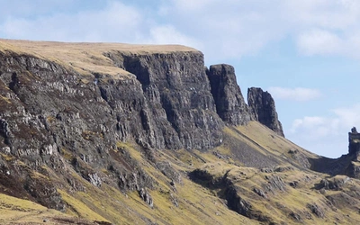
Perhaps the most impressive aspect of Jura's west coast is its remarkable and ostentatious geology. Before my first visit here I was rather uninterested in geology beyond a basic 'these are chalk hills, those are limestone mountains' take on the landscapes I was passing through. In this spirit the obvious point to make about Jura's geological composition is that it is largely comprised of Jura quartzite, a metamorphic rock that has its origins in the late Pre-Cambrian or Dalradian age. The predomination of quartzite is most apparent amid the Paps and the ridges in the island’s north-west. However, on Jura's west coast the sheer abundance of remarkable geological phenomena is quite startling and it was here that my curiosity was finally piqued enough to seek an understanding of the processes at play in the formation of this remarkable landscape.
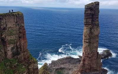
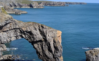
Jura is internationally renowned for the vast raised beaches garlanding the west coast together with the raised shore platforms replete with numerous caves, rock stacks and natural arches.
Geological phenomena
The formation of this landscape has much to do with a process known to geologists as 'glacio-isostatic uplift'. These geological phenomena reflect changes in relative sea level associated with the advance and retreat of ice sheets during the Quaternary Ice Age. During glacial periods, sea levels dropped as fresh waters were held captive by the advancing ice sheets, and rose again when the glaciers melted.
At the same time, the landmass initially sank under the weight of the ice cap then gradually rose again as the ice retreated. The land rebounded at a slower rate than the waters rose hence the sea level was formerly much higher locally than today as beaches, cliffs and shore platforms continued gradually lifting out of the sea. The relative rebound is greater in those areas where the ice sheet was thickest and this is why the uplift is more pronounced towards the north-west end of Jura.
The raised beaches along the west coast are impressively proportioned, occurring as terraces or ‘staircases’ of largely unvegetated shingle ridges, demonstrating the gradual fall in relative sea level. The most impressive raised beaches lie between Shian Bay and Ruantallain, east of Ruantallain, west of Glenbatrick above Loch Tarbert, with perhaps the most remarkable formation being the massive pebble bank east of Glenbatrick, which forms a natural barrier between Loch Tarbert and the freshwater Lochan Maol an t-Sornaich. If you arrive on this beach having approached from the north-west you will notice how beautiful, smooth and curiously patterned the small pebbles are. As you progress south-west along the top of the beach the pebbles become ever larger until they resemble round loaves or curling stones.
Raised beaches do occur on the sheltered east coast, although these are most often covered in vegetation. The absence of vegetation on the west coast’s raised beaches makes these often-huge tracts of large cobbles visually spectacular. The size of the cobbles and the depth of deposits, combined with the scouring effects of wind and rain, have rendered these beaches largely sterile.
The raised shore platform fringing Jura's western coastline makes for a remarkable environment to walk through and explore.
It is possible to walk along the shore platform for much of the way along the west coast, although there are a few impassable sections. The platform is backed by quartzite glacial cliffs left high and dry by the post-glacial 'uplift' while rock stacks, natural arches and numerous caves create an other-worldly atmosphere.
In the summer months much of the platform is shoulder-high in vibrant-green bracken ferns, lending a The Land That Time Forgot feel to the place. Many of the formerly submarine caves are literally cavernous and archaeological excavations show evidence (such as limpet shell middens) of seasonal occupation by Mesolithic hunter gatherers.
Intense volcanic activity
Another striking geological phenomenon frequently encountered on Jura's west coast is the series of linear basalt dikes cut into the quartzite rock. These dikes are often huge and erosion has left some standing like abandoned sections of an immense wall. They are found throughout the island, although predominantly in the south, and are oriented on a south-east–north-west axis. The dikes were formed during a period of intense volcanic activity in the Lower Tertiary period, some 56 million years ago, when up-welling magma filled cracks in the Earth’s crust radiating out from centres of eruption on Arran and Mull. Today, these dikes are most apparent on the west coast where erosion of the less-resistant rock that they are intruded into has left them exposed as natural walls.
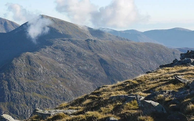
During the last glacial period the summits of the Paps of Jura protruded from the ice sheet as 'nunataks'; the striking appearance of the Paps is due to conical erosion occurring because of the lack of weaknesses and faults in the highly resistant quartzite rock. The quartzite scree blanketing the mountains’ flanks was caused by the frost-shattering effects of the final cold period during the Loch Lomond Readvance (9300bc) after the ice had retreated from Jura at the end of the Devensian glacial period.
Jura is also home to an excellently preserved medial moraine known as Sgriob na Caillich (the old woman’s slide), which extends for 3km (2 miles) westwards towards the coast from the flank of Beinn an Oir – the highest of the Paps. The moraine takes the form of a series of parallel belts of boulders deposited between convergent streams of the ice sheet that swept through the Paps from the east during the last glacial period. The Sgriob na Caillich is best viewed from across the Sound of Islay. It was formed by the retreat of the Late Devensian ice sheet and is regarded as the finest example of a fossil medial moraine in the British Isles.
When visiting Jura it's worth trying to secure a copy of David J Horne's instructive pamphlet, The Geology of Jura. The Jura Hotel usually has copies for sale and the community shop may also keep some in stock.