
Walking in the Bavarian Alps
70 mountain walks and treks in southern Germany


Walking in the Bavarian Alps
70 mountain walks and treks in southern Germany
Guidebook to mountain walks and treks in the Bavarian Alps, on the border of Germany and Austria, between Lake Constance and Berchtesgaden. Accessible from Munich, Salzburg and Innsbruck, these 70 routes range from half-day walks to 3-day hut-to-hut treks. Highlights include the Konigssee and Breitach, Partnach and Hollental gorges.Discover the spectacular beauty of Germany’s Bavarian Alps, where rugged peaks, deep gorges, and flower-filled meadows stretch along the German-Austrian border from Lake Constance to Berchtesgaden. Highlights include ascents to the summit of the Zugspitze (Germany’s highest mountain), visits to the mystical Königssee, dramatic karst landscapes, and the awe-inspiring Schellenberg ice cave. Picturesque villages, opulent baroque churches, and King Ludwig’s fairy-tale castles are just some of the cultural treasures you’ll encounter along the way.
Ideal for walkers of all abilities, this comprehensive Cicerone guidebook features 70 graded walks and treks through the heart of the Bavarian Alps, from gentle valley strolls to challenging high-level routes and multi-day adventures, including the iconic red and purple trails of the Via Alpina.
- Includes 70 graded walks in the Bavarian Alps, with routes ranging from easy 7km (4-mile) walks suitable for families to demanding 22km (13-mile) hikes and multi-day treks up to 400km (249 miles), with walking times from 3 to 11 hours.
- Most walks start from popular towns such as Oberammergau, Mittenwald, Bad Reichenhall, and Berchtesgaden.
- Explore classic Bavarian landscapes, including walks to Neuschwanstein Castle from Füssen and mountain circuits near Garmisch-Partenkirchen and the Zugspitze.
- The main walking season runs from June to September, with valley walks near towns like Berchtesgaden possible from April.
- Each route is accompanied by a 1:100,000 map and downloadable GPX files, plus an at-a-glance information box detailing distance, ascent/descent, grade (1–3), start and finish points, and access by public transport or car.
- Practical advice on travel, accommodation (including mountain huts in the Berchtesgaden and Garmisch regions), local culture, and excursions to Salzburg or Munich.
Plan your walking holiday in the Bavarian Alps with the definitive Cicerone guidebook and discover a region of unspoilt natural beauty, dramatic contrasts, and rich cultural heritage, where every trail leads to a new alpine wonder.
Walking in the Bavarian Alps - Quick Facts
Location: Bavarian Alps, southern Germany, along the German–Austrian border
Number of routes: 70 graded walks and treks
Distance: 7–22 km (4–13 miles) per day walk; multi-day treks up to 400 km (249 miles)
Duration: 3–11 hours per day walk
Areas covered: Oberammergau, Mittenwald, Bad Reichenhall, Berchtesgaden, Füssen (Neuschwanstein Castle), Garmisch-Partenkirchen, Lake Constance to Berchtesgaden
Route type: Well-marked valley walks, mountain paths, and long-distance trekking routes (including Via Alpina)
Difficulty: Easy walks for all abilities to challenging high-level and multi-day treks (graded 1–3)
Terrain: Karst landscapes, alpine meadows, gorges, mountain summits, lakes, and forested valleys
Navigation: 1:100,000 route maps, detailed descriptions, downloadable GPX files
Best season: June to September for high trails; valley walks possible from April
Highlights: Zugspitze (Germany’s highest peak), Königssee, Schellenberg ice cave, Neuschwanstein Castle, picturesque villages, baroque churches, King Ludwig’s castles, Blaueis glacier
Equipment: Sturdy walking footwear, weatherproof clothing, and essential kit for changing mountain conditions
Accommodation: Mountain huts, guesthouses, hotels, and restaurants in base towns and along routes
Author Highlight
"For the walker the advantages of this location are many. For example, it is never far from the valley bottom to the top of a rugged mountain peak, from a picturesque village nestling in the lush green foothills to a lonely alpine tarn. A day in the mountains could be followed by an outing to historic Salzburg (especially if you are based in either Bad Reichenhall or Berchtesgaden) or Munich from where, on a clear autumn day, the mountains seem only a stone’s throw away.”
- Grant Bourne and Sabine Körner-Bourne, authors of Walking in the Bavarian Alps
Printed book
A guidebook with detailed route descriptions, stage breakdowns, accommodation listings, profiles and maps - everything you need on the trail.
ISBN
9781852849290
Availability
Published
Reprinted
13 Jul 2023
Published
19 Jun 2018
Edition
Fourth
Pages
336
Size
17.20 x 11.60 x 1.85cm
Weight
380g
eBook
The complete digital edition of the guidebook, with full route descriptions, accommodation listings, profiles and maps, ready to use on any device. To access your eBook, you will need an eReader app. For more details, visit the eBook FAQs.
Overview map
Map key
Preface
Introduction
History
Culture
Plants and wildlife
Getting there
Getting around
Accommodation
Mountain huts
Climate
Clothing and equipment
Safety in the mountains
Food and drink
Language
Expenses
Using this guide
Maps
Part I The Allgäu Alps
Walk 1 The Nagelfluhkette: a ridge walk between the Mittagberg and Stuiben
Walk 2 Over the Großer Ochsenkopf to Riedberger Horn
Walk 3 A ridge walk between Sonnenkopf and Falken Alpe
Walk 4 The Rubihorn
Walk 5 Edmund-Probst-Haus to the Oytal
Walk 6 Prinz-Luitpold-Haus to Landsberger Hut/Tannheim
Walk 7 Gerstruben
Walk 8 From the Gerstrubental to the Oytal
Valley walks from Oberstdorf
Walk 9 Kanzelwandbahn to Fellhorn and Söllereck
Walk 10 Fiderepass Hut
Walk 11 Gottesacker Plateau
Walk 12 Around the Großer Widderstein
Walk 13 Tannheim to Vilsalpsee
Walk 14 Tannheimer Höhenweg: Füssener Jöchl to Bad Kissinger Hut
Part II The Ammergau Alps
Walk 15 Kalvarienberg
Walk 16 A walk above Hohenschwangau
Walk 17 Bad Kohlgrub to Oberammergau
Walk 18 Over the Laberjoch to Ettal
Walk 19 The Kofel
Walk 20 Along the Sonnenberggrat to August-Schuster-Haus and Linderhof
Walk 21 The Notkarspitze
Part III The Wetterstein, Ester and Walchensee Mountains
Walk 22 Wank, Esterberg Alm and Gams Hut
Walk 23 Partenkirchen to the Krottenkopf
Walk 24 Wamberg, Berggasthof Eckbauer and the Partnachklamm
Walk 25 Schachen Haus and the Königs Haus
Walk 26 Schachenhaus/Meiler Hut to Leutasch
Walk 27 The Zugspitze
Walk 28 Kreuzeck, Knappenhäuser and the Höllentalklamm
Valley walk from Garmisch-Partenkirchen
Walk 29 Soiern Haus, Schöttelkarspitze and Seinskopf
Walk 30 Hochland Hut and Wörnersattel
Walk 31 Kranzberg, Grünkopf and Ederkanzel
Walk 32 The Brunnsteinspitze
Valley walks from Mittenwald
Walk 33 Herzogstand and Heimgarten
Walk 34 The Jochberg
Part IV The Tegernsee and Schliersee Mountains
Walk 35 Brauneck, Achselköpfe and Benediktenwand
Walk 36 The Seekarkreuz
Valley walk from Lenggries
Walk 37 Above Tegernsee
Walk 38 Wallberg and Risserkogel
Walk 39 Wildbad Kreuth to the Schildenstein
Walk 40 The Blauberge
Walk 41 The Roßstein
Walk 42 The Wendelstein
Walk 43 The Breitenstein
Walk 44 Taubensteinbahn to Soinsee and Taubenstein Haus
Walk 45 Jägerkamp, Taubenstein and Taubenstein Haus
Walk 46 Tatzlwurm to Brünnstein and Tatzlwurm
Valley walks from Bayrischzell
Part V The Chiemgau Alps
Walk 47 From the Kampenwand to the Geigelstein
Walk 48 Marquartstein to the Hochgern
Valley walk from Marquartstein
Walk 49 To Hindenburg Hut, Straubinger Haus and the Fellhorn
Walk 50 Winklmoos Alm and Dürrnbachhorn
Walk 51 Winklmoos Alm to the Kammerköhr (Steinplatte)
Walk 52 The Hochfelln
Walk 53 The Rauschberg
Walk 54 From Inzell-Adlgaß to the Zwiesel
Walk 55 Around the Inzeller Kienberg
Valley walks from Ruhpolding and Inzell
Part VI The Berchtesgaden Alps
Walk 56 The Lattengebirge (Predigtstuhl)
Valley walk from Bad Reichenhall
Walk 57 To the alm meadows above Ramsau
Walk 58 The Reiteralpe massif: Hintersee to Neue Traunsteiner Hut
Walk 59 The Hochkalter massif: Ramsau to Blaueis Hut
Walk 60 Wimbachklamm, Wimbachtal and Wimbachgries Hut
Walk 61 Kühroint Alm and Watzmann Haus
Valley walks from Ramsau
Walk 62 The Untersberg massif
Walk 63 Schellenberg Ice Cave
Walk 64 The Almbachklamm
Walk 65 Kehlstein: the Eagle’s Nest
Walk 66 Jenner
Walk 67 The Hagengebirge above Königssee
Walk 68 A three-day hike through Berchtesgaden National Park
Part VII Multi-Day Tours: The Via Alpina
Walk 69 Via Alpina: the Bavarian section of the Purple Trail
Walk 70 Via Alpina: the Bavarian section of the Red Trail
Appendix A Route summary table
Appendix B Further reading
Appendix C Alpine hut accommodation
Appendix D Useful addresses
Appendix E Glossary
Seasons
most valley walks can be attempted early in the season (April-May); the majority of routes are best walked from June-September; lower altitudes until mid-October
Centres
Oberstdorf, Riezlern, Tannheim, Füssen, Garmisch-Partenkirchen, Mittenwald, Walchensee, Lenggries, Tegernsee, Bayrischzell, Marquartstein, Reit im Winkl, Ruhpolding, Inzell, Bad Reichenhall, Ramsau, Berchtesgaden
Difficulty
valley walks suitable for all abilities; main routes are graded 1-3; none of the routes require climbing skills, and no special equipment required
Must See
the Zugspitze (Germany's highest peak), Königssee (a stunning mountain lake), karst landscapes, picture-book towns Oberammergau and Mittenwald, wild mountain gorges, alpine meadows, Neuschwanstein Castle, folklore traditions, opulent baroque churches, scenic rack railways and exhilarating multi-day tours
July 2026
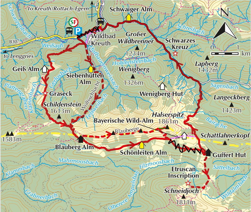
Walk 40 Blauberge route update
Walk 40 has been amended.
The magenta lines indicate how the route changes. It now goes past Bayerische Wild-Alm on the way to Guffert Hut. The direct route (crossed out with black marker) is no longer maintained. Near the end the route no longer follows the road but instead a trail along the Weißach River – the river is always on your right in the direction of Siebenhütten bus stop. Those who don’t have to return to their car can cross the bridge after Schwaiger Alm and walk to the other bus stop shown on the map. Please note that Schönleiten Alm no longer offers refreshments.
The GPX file reflects these changes.
June 2026
Walk 53 The Rauschberg
The walk as described is no longer possible as the cable railway is closed indefinitely. It is, of course, possible to do the walk in reverse, although this would make it far more strenuous. The facilities at the summit are also closed, so you would have to carry your own food and drink.
The local tourist office provides a number of alternatives of a similar degree of difficulty. We would recommend 4 Lake Tour (4-Seen-Weg ) 3.5 hr/11.6km or Jubilee Trail – Wittelsbacher Höhe (Jubiläumsweg – Wittelsbacher Höhe) 3hr/8km. The latter offers a couple of nice restaurants en route, whereas the former offers bathing at designated areas.
September 2021
Author updates
Walk 3
At one point on this route there is a turn-off that is, at present, easily missed. It is situated on the climb up to the Sonnenkopf, a little less than half-way up from where the trail swings left and climbs near Entschen Alpe.
At a bend marked by a sign ‘Stopp – Sackgasse’ (stop – dead end) and, nearby, a wooden sign with ‘Sonnenköpfe’ on it, continue uphill a short distance – the trail is more a four-wheel drive track here. At a tree with a red arrow on it go right and uphill along a narrow track. This is easily missed! The trees are waymarked with faded red dots on this section. Eventually you will arrive at another wooden sign marked ‘Fußweg’. From here on the trail to the summit should be clear enough.
Walk 22 Wank, Esterberg Alm and Tannen Hut
The old Gams Hut has been rebuilt as Tannen Hut (Tannenhütte). The walking signs on the trail have been changed accordingly.
When the hut is closed you will find snack and drink dispensers in an outbuilding.
Walk 65 Kehlstein: the Eagle’s Nest
Variant: With the Obersalzbergbahn to Kehlstein (2½hr to bus stop below Kehlstein Haus) (Corrected Version. GPX file below)
This alternative makes use of the Obersalzbergbahn from Berchtesgaden. From the upper station of the gondola lift walk a short distance uphill from Café Sonneck. Leave the asphalt road at the signposted trail to Kehlstein on the right. The track climbs into the woods and soon comes to a forestry road. This is crossed and the track climbs in the direction of Ligeret and Scharitzkehl alms (signposted).
At the next signposted junction go right (Ligeret - Scharitzkehl) and continue climbing until at another signposted junction our route goes left towards Kehlstein and Ofnerboden. After climbing awhile, the sealed Kehlsteinstraße is crossed, and the trail now follows the signs in the direction of Untere Kehl Alm - Kehlstein. On arriving at another fork go first left and then follow the signs right, uphill, along path 39a to Kehlstein. After a short descent the trail meets up with the routes from Dokumentation Obersalzberg and Ofnerboden. Go right here and continue up to Kehlstein Haus along path 40.
Walk 66 Jenner
The time given should read as 6hr.
Walking Times: It is important to remember that the times given in this guide are the simple walking times without pauses of any kind. They are not the total time required for the walk; it is essential that you factor in the time required for pauses. For every hour that you walk it is necessary to add at least 5 to 10 minutes for pauses – I would suggest 10 minutes if you are unfamiliar with the walk or uncertain of your fitness. On top of this add at least an hour for lunch breaks or unforeseen circumstances; for example, a very slippery descent or pathfinding if waymarks or signs are missing. Taking all this into account for Walk 66 would give you a total time of at least 7½ to 8hr.
When the days are shorter make sure the added time necessary for breaks allows you to reach your destination with at least an hour to spare before it starts to get dark – the bigger your time buffer, the better. On longer walks it is wise to carry a head torch for emergencies.
Bear in mind that a mountain walking holiday is not a chance to get fit; you should be properly fit before you go. Lack of adequate fitness can significantly increase walking times, decrease your enjoyment of a walk and add to the risk of injury. If a climb of 300m at home leaves you panting and red-faced, then a climb of 1000m in the mountains is to be avoided. It is important to match your abilities to the walk.
Tip: The restaurant at the upper station of the Jenner lift offers takeaways; good to know if you forgot to take snacks or would rather picnic somewhere. Don’t forget to take your rubbish with you.
Walk 67 The Hagengebirge above Königssee
Note: The first shady section of the steep and rocky descent from Seeleinsee to Priesberg Alm can be very slippery. This can slow you down quite a bit, as extra care is necessary.
Free Royal Mail 48 postage on UK orders. European postage is £3.50 per item. Worldwide postage is £5.50 per item. If you're not happy with your purchase for any reason, we'll give you a full refund.
Learn moreDiscover the Cicerone App
The Cicerone App brings decades of expertise straight to your phone, making it easier than ever to plan and enjoy your adventures wherever you are. For use with In-App guides — not compatible with eBooks.


Popular related guides


