 New
New
Great Mountain Days in Snowdonia
40 classic routes exploring Snowdonia


Great Mountain Days in Snowdonia
40 classic routes exploring Snowdonia
Inspirational guidebook to 40 great mountain day walks and scrambles in Snowdonia. Inspirational routes for all abilities across the National Park with routes up Snowdon and Moel Eilio, the Glyderau, the Carneddau, Eifionydd, Siabod and the Moelwynion, Rhinogydd (the Harlech Dome), Migneint and the Arans and Cadair Idris and the Tarrens.Take on 40 of Snowdonia's greatest mountain days, from the classic Snowdon Horseshoe and the dramatic ridges of the Glyderau and Carneddau to the remote Rhinogydd, the wild Arans, and the magnificent sweep of Cadair Idris above the Mawddach Estuary. Spanning eight distinct mountain regions across the Snowdonia National Park, this is a handpicked collection of classic routes and lesser-known gems across some of the finest mountain terrain in Wales.
Designed for experienced walkers and scramblers ready to push beyond the well-trodden paths, this large-format Cicerone guidebook describes 40 graded mountain routes across Snowdonia, illustrated throughout with Harvey map extracts and topo diagrams by Lakeland artist Mark Richards. Routes are graded from moderate to arduous, with some involving mild scrambling or long days on rugged and complex terrain.
- Choose from 40 classic and lesser-known mountain routes across eight regions of Snowdonia, covering Snowdon and Moel Eilio, the Glyderau, the Carneddau, Eifionydd, Siabod and the Moelwynion, the Rhinogydd, Migneint and the Arans, and Cadair Idris and the Tarrens, with a mix of horseshoe circuits, ridge traverses, and summit days.
- Discover highlights including the Snowdon Horseshoe and the Watkin Path, Tryfan and the Bristly Ridge, the Nantlle Ridge, the Cwm Eigiau Horseshoe, the Carneddau end-to-end, Cnicht and Cwm Croesor, Rhinog Fawr and Fach, Aran Fawddwy, and three routes on Cadair Idris.
- Navigate with confidence using Harvey map extracts and topo diagrams by Mark Richards included for every route, with guidance on the recommended Harvey Superwalker and OS Explorer sheets covering all eight mountain regions of Snowdonia.
- Select routes suited to your ability using clear grading from moderate to arduous, with notes on terrain complexity, scrambling, and seasonal conditions to help you plan safe and rewarding mountain days throughout the year.
- Prepare thoroughly with introductory sections on weather, mountain environment, map and compass skills, and practical advice on getting the most from Snowdonia's mountain landscape in every season, including winter.
- Extend your exploration with the companion Cicerone title Great Mountain Days in Scotland, which together with this guide offers a collection of the finest mountain days across two of Britain's greatest mountain national parks.
Explore the mountains of Snowdonia with confidence using this trusted Cicerone guidebook. Whether you are new to the national park or returning to discover routes beyond the familiar classics, this is the essential companion for anyone who wants to experience Snowdonia's mountain landscape at its very best.
Great Mountain Days in Snowdonia – Quick Facts
Location: Wales – Snowdonia National Park
Routes covered: 40 graded mountain walks and scrambles
Difficulty: Graded from moderate to arduous; map and compass skills recommended for all routes; terrain often bouldery, marshy, complex, or trackless; some routes include mild scrambling
Terrain: Mountain ridges, horseshoe circuits, remote summits, rocky scrambles, and high moorland across eight distinct regions of Snowdonia
Navigation/mapping: Harvey map extracts and topo diagrams by Mark Richards included for every route; Harvey Superwalker 1:25,000 and OS Explorer 1:25,000 sheets recommended for on-the-ground navigation
Regional coverage: Snowdon and Moel Eilio; Glyderau; Carneddau; Eifionydd; Siabod and the Moelwynion; Rhinogydd; Migneint and the Arans; Cadair Idris and the Tarrens
Key centres: Conwy, Aber, Betws-y-Coed, Ffestiniog, Dolgellau, Capel Curig, Llanberis, Beddgelert, Bala, Machynlleth
Highlights: Snowdon Horseshoe, Tryfan and the Bristly Ridge, Nantlle Ridge, Cwm Eigiau Horseshoe, Carneddau end-to-end, Cnicht, Rhinog Fawr and Fach, Aran Fawddwy, Cadair Idris
Best time to go: Year-round; check the weather forecast before you go and choose your route accordingly; take appropriate gear for all seasons including winter
Author Highlight
"Today, for better or worse, the mountains of Snowdonia are everyone’s playground. Nevertheless, in these Great Mountain Days you will discover the companionship of solitude, the sound of silence and the tang of wild places, for all are still here, waiting.”
- Terry Marsh, author of Great Mountain Days in Snowdonia
Printed book
A guidebook with detailed route descriptions, stage breakdowns, accommodation listings, profiles and maps - everything you need on the trail.
ISBN
9781852845810
Availability
Published
Reprinted
22 May 2017
Published
17 Mar 2010
Edition
First
Pages
240
Size
24.00 x 17.00 x 1.70cm
Weight
670g
eBook
The complete digital edition of the guidebook, with full route descriptions, accommodation listings, profiles and maps, ready to use on any device. To access your eBook, you will need an eReader app. For more details, visit the eBook FAQs.
Preface
Introduction
About this guide
Weather to walk?
Before you start
Recreation and the mountain environment
The Walks
SNOWDON AND MOEL EILIO
1. Snowdon Horseshoe
2. The Rhyd Ddu Path and the Snowdon Ranger
3. The Watkin Path and Yr Aran
4. The Pyg Track and the Miners’ Track
5. Moel Eilio Horseshoe
GLYDERAU
6. The Glyders by the Bristly Ridge
7. Y Garn to Elidir Fawr and Carnedd y Filiast
8. Tryfan
9. Bwlch Tryfan, Y Foel Goch, Gally yr Ogof and Cefn y Capel
CARNEDDAU
10. Conwy Mountain
11. Tal y Fan
12. Drum, Foel-fras, Garnedd Uchaf, Drosgl and the Aber falls
13. Llyn Anafon and the eastern Carneddau
14. Pen yr Ole Wen, Carnedd Dafydd, Carnedd Llywelyn and Pen yr Helgi Du
15. Cwm Eigiau Horseshoe
16. Creigiau Gleision and Llyn Cowlyd
17. Llyn Geirionydd and Llyn Crafnant
18. The Carneddau: end-to-end
EIFIONYDD
19. Mynydd Mawr
20. The Nantlle Ridge
21. Moel Hebog, Moel yr Ogof and Moel Lefn
SIABOD AND THE MOELWYNION
22. Aberglaslyn, Llyn Dinas and Cwm Bychan
23. Moel Siabod
24. Cnicht and Cwm Croesor
25. Moelwyn Mawr and Moelwyn Bach
26. Moel Meirch and Ysgafell Wen
RHINOGYDD (THE HARLECH DOME)
27. Bwlch Tyddiad and Bwlch Drws Ardudwy
28. Rhinog Fawr
29. Rhinog Fach and Rhinog Fawr
30. Y Llethr and Diffwys
MIGNEINT AND THE ARANS
31. Carnedd y Filiast
32. Arenig Fawr and Moel Llyfnant
33. Rhobell Fawr
34. Aran Benllyn
35. Aran Fawddwy
CADAIR IDRIS AND THE TARREN HILLS
36. Cyfrwy, Pen y Gadair and Mynydd Pencoed
37. Pen y Gadair from Ty Nant
38. Mynydd Pencoed, Pen y Gadair and Mynydd Moel
39. Tyrrau Mawr and Craig y Llyn
40. The Tarren Hills
Appendix 1: Concise Walk Reference and Personal Log
Appendix 2: Bibliography and Further Reading
Appendix 3: Glossary of Welsh Words
Index
Seasons
all year round but check the weather forecast before you go, choose your walk accordingly and take appropriate gear
Centres
Conwy, Aber, Betws-y-Coed, Ffestiniog, Dolgellau, Capel Curig, Llanberis, Beddgelert, Bala, Machynlleth
Difficulty
routes graded from moderate to arduous; map and compass skills recommended for all routes; terrain often bouldery or marshy, complex and trackless
Must See
classic summits such as: Snowdon, Cadair Idris, Pen yr Ole Wen; horseshoes such as: Carneddau, Cwm Eigiau, Moel Eilio; ridge routes and scrambles such as: Tryfan, Nantlle Ridge and family days out including Conwyn Mountain and Aberglaslyn Gorge
To aid visualisation, routes are depicted both as line diagrams and as customised HARVEY maps. The former, drawn by Lakeland author and artist Mark Richards, give an aerial perspective of the walks, while the latter pinpoint the key detail covered in the route description. HARVEY maps owe their origins to orienteering, and their bold symbols and distinctive colours make them well suited to outdoor use. Note that key landmarks that feature on the maps and diagrams appear in bold in the text to help you plot the route.
Although the guide contains map extracts and diagrams, you are strongly advised always to take with you the relevant sheet map for the route, not only for safety reasons, but also to give a wider picture of the landscapes you are walking through.
At present, HARVEY publish three 1:25,000 Superwalker maps of Snowdonia; Snowdon and the Moelwynion, the Glyderau and the Carneddau, and Snowdonia South, covering the Rhinogs, as well as a 1:40,000 British Mountain Map Snowdonia.
Alternatively, the following 1:25,000 Ordnance Survey Explorer maps cover the areas described: OL17 Snowdon/Yr Wyddfa, OL18 Harlech, Porthmadog and Bala and OL23 Cadair Iris and Lyn Tegid.
April 2026
Walk 22 height gain
The height gain should be 340m, not 540m.
September 2021
Walk Five: Moel Eilio Horseshoe
Walk Five: Moel Eilio Horseshoe
A new fence has been installed on the descent from Moel Cynghorion which does not have a stile by which to cross it. This is being investigated by the National Park Authority. In the meantime, walkers are advised to backtrack to Bwlch Maesgwm and descend northwards from there on a clear track that leads down to Llanberis.
October 2019
Walk 40
It has been reported that the descent NE from the summit of Tarrenhendre is becoming blocked by self-seeded spruce, as noted originally. No investigation has yet been carried out, and feedback from other walkers would be welcome until such time as the issue can be checked. Meanwhile, there is the possibility of back-tracking to the gate at SH703046 and descending from there. Another, untested, possibility is to descend NW from the summit to the boundary of Access Lane and to re-enter the plantation there via a fire break to rejoin the original route.
July 2011
Route update and corrections
Moelwyn Mawr: pages 146 and 147.
Having recently rewalked this route, the author has rewritten the paragraphs of the route description from "Behind the main quarry" to "climb to the summit" as follows:
"Behind the main quarry buildings is a large and wet tunnel into the hillside, and beside it a slaty ramp by which you gain higher ground (resist the temptation to enter the tunnel). The ascent passes tiny Llyn Croesor, which looks forlorn among so much darkness, but with the sun in its heaven, Llyn Croesor sparkles with the best of them.
Once above the ramp, you eventually arrive at a large reedy area framed by spoil that has been shaped into a trackbed. Off to the left, Moel yr Hydd looks inviting, but the easiest way to it means trekking far off-route beyond the quarry site to a low col to the south-west of the summit and walking easily up from there. The direct ascent of Moelwyn Mawr bears right from the reedy area, following a clear if damp path towards a ladder-stile, which is not needed, as the path passes to its left, and follows a clear route onto the shallow north ridge of Moelwyn Mawr and then steeply up to the squat and tidy trig pillar on the summit, trending right near the top. It is possible to count fifteen or more lakes from the top of Moelwyn Mawr, and the view, notwithstanding the dereliction, is one of the finest in Wales for extent, beauty and diversity.
The continuation to Moelwyn Bach will call for some thought. Begin by going east from the trig, but only for about 100m, and then turn right and descend the south ridge in a series of rock steps, crossing the subsidiary summit of Craig Ysgafn, marked by a large cairn. Above, Moelwyn Bach’s crags look impenetrable and shaky, not so much a scramble as a crumble. They are avoided them by ascending a clear path diagonally left which leads to the grassy eastern spur of the mountain from where the summit is readily attained."
July 2010
There is a correction to the map in Walk 17 on page 103.
The route description is correct but the marked route on the map after Llyn Bychan is wrong. You should take the first track on the right after Llyn Bychan (indicated correctly by the dashed red line on the detail map below) not straight on along the main forest track as indicated incorrectly on the map (see solid yellow line on detail map below).
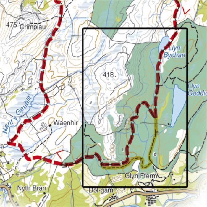
Walk 17 update (645.69 KB)
Free Royal Mail 48 postage on UK orders. European postage is £3.50 per item. Worldwide postage is £5.50 per item. If you're not happy with your purchase for any reason, we'll give you a full refund.
Learn moreDiscover the Cicerone App
The Cicerone App brings decades of expertise straight to your phone, making it easier than ever to plan and enjoy your adventures wherever you are. For use with In-App guides — not compatible with eBooks.


Popular related guides


