5 of the best short walks in County Kerry

County Kerry is along what has become known as the Wild Atlantic Way, a driving route up the west coast of Ireland that takes in all the famous spots. But as with any special place it pays to get further away from the car parks and experience the landscape more personally. Here, Alex Kendall chooses 5 of what he thinks are the best short walks in County Kerry.
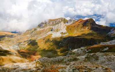
The south-west of Ireland hosts the country’s highest peaks. This is the place to go to summit Carrauntoohil, the highest point in the country, and to walk and scramble along the thrilling ridge of the Macgillycuddy’s Reeks, which comprises several other 3000ft peaks in what must be one of the finest ridge walks in the British Isles.
But big mountains and famous routes shouldn’t detract from the stunning natural beauty of the area. Much like Snowdonia, step away from the famous peaks and you’ll find wild, rough lands populated by rocks, heather and frequent, charismatic Irish bogs. Step even further away and you’ll reach the coast. This is no gentle lowering of the hills to the waves. The sea here has smashed the land apart; ranges of hills end abruptly in cliffs hundreds of metres high, and rocky islands appear as the bodies of the defeated hills.
The majority of the walking in Kerry is on two of the peninsulas that dive off south-west into the Atlantic. In the north is the Dingle peninsula, home to Mount Brandon, the most westerly point on the Irish mainland, and the Blasket Islands. South of Dingle, over Dingle Bay, the Iveragh Peninsula rises up to dominate the county. Here are the highest mountains, the rough miles of moor and the dozens of beaches and seemingly endless coast that make it easy to forget that this is a peninsula at all. Out to sea, the spear-tip shapes of the Skellig Islands bring people from all over the world to marvel at the beehive huts of the early Christian monks, which have stood the test of the centuries, even as waves batter the rocks, unsheltered from the thousands of miles of ocean that stretch from here to Canada.
Further south still, Kerry also encompasses the northern coast of the Beara Peninsula around Kenmare Bay, sharing the rest with County Cork. Inland, the hills peter out beyond Killarney, leading to views from the eastern hills of the vast panorama of central Ireland; rolling fields, dotted with woods and dashed an emerald green in the surprisingly frequent sunshine.
If you’re looking for some walks to get you started, then here are five of my favourite short walks on the Dingle and Iveragh Peninsulas. They should all take between two and four hours, not including extended stops on the beach! I would describe them as moderate, as there are some ups and downs (the coast is far from flat), apart from the Inch Beach walk, which is really just an excuse to go swimming.
Brandon Point
On the north coast of the Dingle Peninsula, the range of hills that culminates in Mount Brandon descends to the sea. From the sands of Brandon Bay, the land ripples up in ever-steepening slopes that head north to Brandon Point. At the car park here, famous as a spot for birdwatching, a circular trail takes in some of the best views of the area. A path leads straight up the nearby hill of An Buaicin, passing a watchtower built to protect independent Ireland. All along this ascent, the view over the sea includes the Magharee Islands and Tralee Bay, and on a good day the hills of Connemara dot the northern horizon. Look out for sparrowhawks, fulmars and choughs.
Beyond An Buaicin, the trail undulates towards the top of the cliffs overlooking the bay of An Sás, or ‘Sauce Creek’. This impressive bay is totally hidden from roads, tucked away in the north of the peninsula, and so walking this route is one of the only ways to see it, although goats were farmed here and people made a living on these seemingly bare hillsides. The trail runs alongside An Sás before breaking away inland to descend towards a track, with the peaks surrounding Mount Brandon visible in the south.
Once the track is reached, it descends gradually back down to the road near Brandon Village. This descent looks over Brandon Bay to the hills beyond, with Beenoskee rising above them. Evidence of turf cutting can be seen on the hillsides as you descend, and once on the road there are several small art galleries in artists’ houses to visit.
Although there are a few miles here on the road to complete the circuit, it is relatively minor, and goes only to Brandon Point. The sea can be seen all the way, as well as a few small beaches where you may be tempted to head to after the walk.
This circuit of the land around Brandon Point is a fine example of how quickly you can reach wild and remote places from a relatively popular car park.
Bray Head
In the far west of the Iveragh Peninsula, Valentia Island is reached either by a ferry from Reenard Point, or via the bridge from Portmagee. Its name comes from the Spanish traders who used to sail these waters, but its original Gaelic name is Oileán Dairbhre, meaning the Isle of Oakwoods.
The western end of the island sees a hill rise up from the plains, and culminate in Bray Head, where there is a car park and a sign advertising it as one of Ireland’s looped walks, a series of hundreds of waymarked trails that have been plotted out all over the country. Even the view from the car park is outstanding.
The route heads up a gently rising track towards Bray Head. Southwards, the Kerry Cliffs drop into the sea, accompanied by the booming concussion of the waves hitting the rocks. Out to sea, the Skellig Islands are visible, where early Christians built beehive huts and where seabirds now find sanctuary in the relative inaccessibility.
The track ends at the ruins of a Napoleonic watchtower, built on a neck of land with the narrowing promontory ahead and the bulk of the hill behind. Many people stop here, but you can walk further out along the peninsula, as the land grows steeper on the right and the cliffs get closer on the left.
The sight of the rocks being smashed by the Atlantic far below really brings it home that you are on the very edge of Europe.
The walk becomes a loop by following the cliffs north-east, where there are a set of footpath posts. The path can be wet, but the view ahead over the Dingle Peninsula and the Blasket Islands over the water more than compensates. The route takes you gently down in a rough line back to the car park, over heather and grass where on a clear day the Macgillycuddy’s Reeks are clear on the horizon.
Derrynane
As the south coast of the Iveragh Peninsula bends north, a cluster of islands and a long pristine beach make up Derrynane Bay. The Kerry Way, a long-distance walking route that runs right round the peninsula has two options here, along the beach or over the higher ground of crags and woodland. These two options mean that an excellent circular walk can be created, taking in both.
Starting from Caherdaniel, or further along the road at one of the car parks near Derrynane House, take the higher route first, passing through oak woodland coated with moss as you climb higher over the bay. On leaving the woods, the view down to the coast reveals an area dotted with small bays, with the islands of Deenish and Scariff dominating the horizon. The descent to the shore is on a track through Bunavalla, which leads down to a harbour and then, when it feels like a dead-end, a secretive path through dense vegetation, across steps cut into the rock leading to views out of hidden coves.
This was one of the Mass paths, trails that Catholics used during the reign of Henry VIII to get to secretive locations where they could conduct mass.
This fantastic stretch of coastal path throws you out opposite Abbey Island, which is only an island at high tide. Most of the time is it a few steps to walk across the sand separating the island from the mainland, with the strange sensation of seeing the sea on both sides of the beach. The island is named after the 12th century Augustinian abbey, whose ruins stand on its southern shore. It is possible to walk around the island using rough paths; just make sure you don’t mistime it and become cut off by the tide!
The rest of the walk back is along the beach, then inland past a wetland reserve and farmland as the sea becomes salt marsh. Alongside the road stands an Ogham stone, a standing stone with marks on it from the ancient Gaelic written language of Ogham, which was used in the early medieval period.
Lord Brandon’s Cottage
The Killarney National Park encompasses the lakes and hills to the west and south of Killarney. Although relatively small, the national park has within it great variety and beauty, and is the perfect place to begin to get to know the mountainous landscape of central Iveragh.
The best way of seeing this landscape is to follow the Kerry Way on a linear walk from Lord Brandon’s Cottage to Killarney town. The day can begin with a boat trip from Ross Castle on the shores of Lough Leane, up past the three lakes and river narrows, deep into the hills to reach Lord Brandon’s Cottage.
Start the walk back by staring up at the edge of the Macgillycuddy’s Reeks. The trail then leads along the western edge of Upper Lake with its many tiny islands and backdrop of the Purple Mountain.
Beyond the lake, the route enters ancient hillside woodland, coated with moss, before reaching Derrycunihy Church. From peaceful lakeside views the route rises into Esknamucky Glen, a high moorland where the easy track allows plenty of time to gaze around at the rough landscape of exposed rock and stunted trees.
Past Torc Mountain, the trail begins its descent, re-entering woodland on the way to the famous Torc Waterfall. From here it is an easy wander through parkland to Muckross House, past the middle lake of Muckross. Unfortunately, a large hotel makes it hard to follow the lakeshore all the way back to Ross Castle, so a bit of road walking is needed at the end to bring you back into Killarney.
Inch Beach
On the south coast of the Dingle Peninsula, a great spit of land reaches out into the sea, creating Castlemaine Harbour and protecting it from the worst ravages of the Atlantic. There are actually three spits reaching into this stretch of water from the mainland, but the largest, Inch Beach, is the only one that roots itself in the Dingle Peninsula.
It is a striking place. Nearly 5km long, the western edge is a sandy beach, while the eastern half is a dune system, cloaked with marram grass and home to specialised salt-loving plants and wading birds. The walk itself is an out-and-back, as far as you want along Inch Strand and then back again, although variety can be found in walking the rough trails that snake among the lower sand dunes before rejoining the beach.
The view is incredible, with miles of waves hitting the beach combined with a western vista of the mountains of Dingle on one side with the mountains of Iveragh on the other.
The walk is also entirely flat, and there’s a café nearly on the beach itself, so it really is accessible to everyone. It is also a walk that is perfectly possible and more than advisable for you to do barefoot, and since it faces west, for the sunset.