How to climb Ben Nevis
Reaching the summit of Ben Nevis is the realisation of a dream for many. Based on many visits, Sean McBride tells you how to get there and how to climb it.
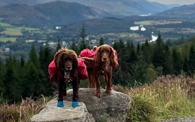
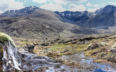
“What the… HELL!?” my youngest daughter Julia exclaimed. I knew those words would have been so much less polite if she hadn’t been talking to her dad. We had just finished a long, steady climb on a rocky path full of loose scree on the summit plateau of Ben Nevis. Before we could actually stand on the highest point on mainland Britain, however, another steep and unexpected rocky path wound its way above us.
I remembered the area from a previous ascent to the summit in 2016. In front and to the left I could see glimpses of the top of the spectacular North Face of the mountain. Just inches from the path the open mouth of gulleys yawned wide and deadly. Stumbling into one of these was a 1000ft sheer drop right down the North Face to certain death. We stopped and took a selfie at every one. Soon we were standing triumphantly on top of the summit cairn among the rocks and the rubble of the ruined observatory built in the 19th century to monitor weather. Its presence was the very reason the path we had just ascended was even there in the first place. Back then, ponies carried supplies. Nowadays the path brings tourists. Climbers and trekkers of every ability arriving in droves. You have to queue to get onto the summit cairn. Clouds swirled around obscuring our view of everything. On rare occasions, however, as happened today, they clear just for a moment, and you get to see forever.
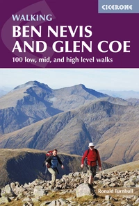
Ben Nevis and Glen Coe
100 low, mid, and high level walks
£16.95
Guidebook to walking in Scotland's Ben Nevis and Glen Coe region, featuring 100 graded walks of 2 to 21 miles. The routes range from gentle walks to long, challenging walks with overnight bothy stays. The routes include walking near Kinlochleven, Fort William, the Grey Corries, the Mamores, the Black Mount and Ben Cruachan.
More informationHow tall is Ben Nevis?
Ben Nevis is the collapsed dome of a cataclysmic volcanic eruption that happened some 350 million years ago. The resultant formation, rising some 4411ft (1345m) above mean sea level, is the highest point in the British Isles.
How do you get to Ben Nevis?
Fort William sits in the Scottish Highlands at the end of Loch Linnhe on the west coast of the country. The foot of Ben Nevis is about a mile outside the town and can easily be reached on foot. The nearest airport is Inverness, about a 2-hour drive northeast of the town. International travellers can also fly into Glasgow or Edinburgh 3 hours to the south and then catch a bus, train, or drive north along the A82 from Glasgow.
Whatever mode of transport you take going north from Glasgow to Fort William, the views along the route are incredible. First you will travel along the beautiful shores of Loch Lomond before heading into the mountains to the north. Then passing through the jaw dropping mountains of Glen Coe, steeped in beauty and history before heading along the edge of loch Linnhe itself to reach the town.
Accommodation in the area
From luxury hotel to glamping hut and everything in between, there are plenty of options for accommodation in and around Fort William. Despite this, many venues are booked out well in advance so it’s best to plan ahead.
The Glen Nevis Campsite sits just outside Fort William at the foot of Ben Nevis and offers pitches for tents and campervans. There’s everything you need here for a cheap and comfortable stay with a fully equipped shop, washing areas and shower blocks. There’s also a restaurant and bar just a short walk from the campsite.
What are the route options?
Main Route: Mountain Path
The Mountain Path climbing out of Glen Nevis on the south side of the mountain is by far the most popular route to ascend Ben Nevis. Covering some 5 miles from start to summit, this route is mostly on a well-constructed, easy-going path. There are some short, steep, rocky steps along the way, but properly equipped trekkers of any ability can reach the summit through some perseverance in good weather.
The route starts at the Ben Nevis Visitor Centre in Glen Nevis, just across the road from the Glen Nevis Campsite. You cross a bridge over the river Nevis and then start to ascend a clear rocky path across the lower face of the mountain.
Soon, the going gets rocky and steeper as you turn away from Glen Nevis and into a steep gully. From here a well-constructed path takes you up the side of the gully. Eventually you will reach flatter, open ground with a small lochan. This part of the walk is called the Halfway Lochan because you are now about halfway up the mountain. From here you can see almost to the summit of the mountain towering above you. More often than not, the summit will be hidden in the clouds.
Soon, the path crosses the foot of a small and beautiful waterfall at a point in the route known as the Red Burn. From here, the climbing begins again in earnest as you continue to ascend the path. The ground becomes rockier and looser as you traverse a series of switchbacks on the path that are known as the Zig Zags.Eventually, the terrain flattens somewhat again as the summit plateau is reached. It should be noted that there are still a couple of ascents on this plateau before the actual summit is reached.
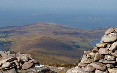
A series of cairns line the path at this stage to guide climbers on to the true summit. Caution should be taken to stay on the main path on the final approach to the summit especially in poor visibility, snow, or both. Just a few feet from the path several steep gullies open up and drop down the North Face of the mountain. The summit area is large and can appear almost like the ruins of a small village among the rocks. As well as the summit cairn, the area is strewn with ruined walls and buildings that comprise the ruins of the observatory built in the late 19th Century, as well as a rescue hut.
Not the ‘Tourist’ Route!
For a long time, this ascent was known as the ‘Tourist’ Route, but the name was changed because the term ‘tourist’ was leading to misunderstandings that could have serious consequences. The summit of Ben Nevis can be covered in snow all year round and, especially in winter, can be deadly. The top of the gullies beside the path at the top of the North Face can become covered with snow. It is quite possible for an unwary walker just feet from the path to stray onto, and fall through the snow into, one of these gullies. Such a fall would likely be fatal.
The top section of the route leading up to the Summit Plateau known as the ‘Zig Zags’ can also be deadly in winter. When winter snow falls it can bury the path completely on this section of the mountain. Without the path, this part of the mountain becomes a steep, deadly 2000ft (600m) slope that can be ascended only by those with full winter mountain equipment and the training to use it. As with any other high mountain, the weather can be unpredictable, dropping from fair to freezing in a matter of minutes. Winds can reach hurricane level and, with the summit of the mountain often in the clouds, visibility can be poor.
Proper navigation with a map and compass can become key. In short, even on the well-established Mountain Path, climbers still must respect the deadly environment they are ascending into.
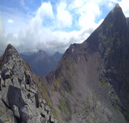
The North Face
The Mountain Track out of Ben Nevis is not the only way to climb this mountain. Winter Climbs: Ben Nevis and Glen Coe offers a selection of hundreds of the best winter climbs on Ben Nevis and in the Glen Coe area, categorised by type, from straightforward Grade I snow gullies and ridges through to extreme test pieces above Grade VIII. It includes notes on their formation and advice to help maximise your chances of finding the best conditions.
Near Torlundy to the north of Fort William, just off the A82, the North Face Car Park is the starting point for the more experienced and adventurous mountaineers. Hardened mountaineers often set out from here to ascend one of the several climbing routes up the North Face. The Ledge Route, Observatory Ridge and Tower Ridge, are all legendary names to me. Even looking at the mountain face that hosts them all I could still scarce imagine the sheer terror yet exhilaration of setting foot on any of them. With every footfall at the junction of the adventure of a lifetime or the end of it.

Winter Climbs: Ben Nevis and Glen Coe
Selected snow, ice and mixed routes in a two-volume set
£25.00
A selection of hundreds of the best winter climbs on Ben Nevis and in the Glen Coe area, categorised by type, from straightforward Grade I snow gullies and ridges through to extreme test pieces above Grade VIII. Includes notes on their formation and advice to help maximise your chances of finding the best conditions.
More informationCarn Mor Dearg
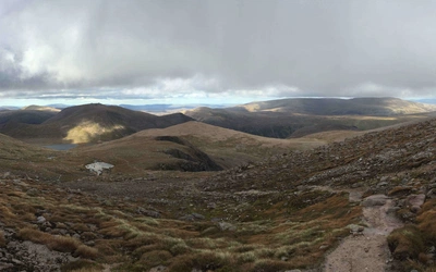
For those with some experience and a head for heights, the summit of Ben Nevis can also be reached via the CMD Arete, setting out from this car park. The CMD Arete is a razor sharp, rocky ridge that stretches for about a mile and a half connecting Carn Mor Dearg (Munro) to Ben Nevis. To complete this route, you would have to ascend to the summit of Carn Mor Dearg, then traverse the CMD Arete before summiting Ben Nevis after climbing off its far end. Descending the Mountain Path on Ben Nevis to an area called the Halfway Lochans, you then must move round the mountain, descend a few hundred feet cross country, and cross a small river to get back onto the route to the North Face Car Park. Those with the experience, equipment, and endurance to complete this long and arduous route are rewarded with spectacular views and an amazing day of adventure.
A brief history of Ben Nevis and Fort William
The summit observatory was built in 1883 with a pony track ascending from Glen Nevis being built at the same time. The mountain was first summited on 17 August 1771 by James Robertson, a botanist from Edinburgh. Today, 100,000s of visitors climb to the summit of Ben Nevis via that track, now known as the Mountain Path, every year.
The nearest town to Ben Nevis is Fort William. A wooden fort was originally constructed in the area in 1654 in order that Oliver Cromwell’s troops could control the local Clan Campbell. A town grew around the fort and took its name, Fort William, after King William who took over the British throne in 1688. The town became a significant part of the Jacobite uprising in 1745 as forces loyal to Bonnie Prince Charlie, whom the Jacobites claimed was the legitimate King of Britain, tried to restore him to the throne. Today, Fort William is a bustling town with the biggest population in the Highlands outside Inverness.