A walk through history on The Vanguard Way
Ali Rowsell follows in the footsteps of The Vanguards to discover an easily accessible, high-quality route through open countryside and woodland. With far-reaching views across southern England and a history lesson around every corner, it’s a walk that fires the imagination.
The Vanguard Way is a 66-mile (106km) trail from the sprawling suburbs of Croydon, London, to where the South Downs National Park meets the English Channel. Along the way the route passes through the Surrey Hills and the High Weald, two Areas of Outstanding Natural Beauty (AONB) and crosses two National Trails; the North Downs Way and South Downs Way.
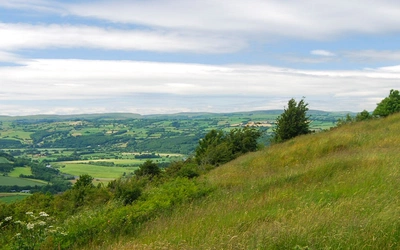
The path undulates north–south through the geological folds of the Weald anticline, offering panoramic views across southern England, the Downs, the Weald and Ashdown Forest. This culminates on the Sussex Heritage Coast, with far-reaching views across the Seven Sisters Country Park and Cuckmere Valley, both of which are Sites of Special Scientific Interest (SSSI).

So, why the Vanguard Way? Well, I like to consider myself an outdoor adventurer with a vivid imagination and a passion for military history, so the name captured me while perusing an OS map one day. What was this trail? Was it the route of an advancing military force? Not quite.
The Vanguard Way was launched following a proposal in 1968 by the London-based Vanguard Rambling Club, a group of merry hikers who enjoyed two of the finest things in South East England; the Downs and the local brew. What an awesome group!
I have to say, of all the long-distance paths I have ever roamed, this is one of the best in the South East. It is a high-quality, established route through some of the best bits of the Shire, led by a group of trailblazers: The Vanguards.
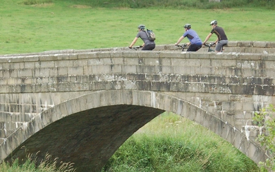
The Vanguard Way follows public rights of way and is mostly composed of footpaths through farmland, open fields, woods and heathland, and is well signposted throughout. Some sections follow narrow country lanes and roads, although these are short and not on major routes. There are several crossings over major roads, such as the A26, A22 and A27, as well as a bridge over the M25, which is the most unattractive 50m of the entire route. There is regular access to public transport links such as trains and buses throughout, making day trips more accessible.

As with all walks, it depends on the speed and fitness of the individual, the time you have and the available transport. Therefore, I have split the walk into four sections, starting and finishing at transport hubs for ease of onward travel.
1. East Croydon to Edenbridge (28km, 6hr 30min)
2. Edenbridge to Buxted (33km, 8hr)
3. Buxted to Berwick (28km, 6hr 30min)
4. Berwick to Newhaven (17km, 4hr)
Escaping London
Starting at the regional transport hub of East Croydon train station, footpaths intermingle between housing estates, through small woods and recreational grounds such as Combe Park, Littleheath and Selsdon Wood. Luckily, the escape route from the suburban sprawl into the green belt is short lived and you soon join part of the London Loop long-distance path, a 150-mile circular walk around London that is split into 24 sections.
The gentle ascent up the dip slope of the North Downs to Farleigh brings you to a 170m-high vantage point across the London skyline. Famous central London buildings can be seen in the distance, reminding you just how close you are. A surprise medieval jewel is discovered shortly after – St Mary the Virgin Church, a Grade I-listed building, built circa 1100. The village of Farleigh and its manor house appear in the Domesday Book of 1086 and are definitely worth a visit.

Continuing south-west for 3km, passing the welcoming pub on the green at Chelsham, you arrive at Nore Hill, with panoramic views across open, rolling downland. Nore Hill Chalk Pinnacle is the smallest nature reserve in the country and was the first Geological Local Nature Reserve, established in 1973. It is now regarded as a Regionally Important Geological and Geomorphological Site due to tall isolated pinnacles that were discovered in the early 20th Century. These formed as a result of exposure and erosion of the chalk, which was laid around 85 million years ago. Over the years, they were buried under sand and gravel, which was then extracted when the site became a quarry. Unfortunately, all that remains is a small dome in the centre of the hollow.
The final ascent to the high point (265m) of the North Downs follows a chalk bridleway up to a blot on the landscape; an antenna and water tower serving the local area.
Luckily, the panorama south from the ridgeline over the steep, scarp slope offers stunning views along the Downs and across the Weald anticline.
Unfortunately, the dreary daily hustle of the M25 car park can be seen (and heard) between intermittent hedgerows and trees at the foot of the scarp slope.

Descending the beech plantation, you join the North Downs Way National Trail and the Greensand Way long distance path. As you traverse along the bottom of Titsey Plantation, you come across an astonishing feature you would never have known was there – keep your eyes peeled! This is a marker the Vanguards placed to commemorate where the Greenwich Meridian line passes through the trail. It is in the edge of the treeline and could be easily missed.
Before the footbridge across the M25, you pass through Titsey Place, a 16th century manor house and its gardens, which is one of the largest surviving historic estates in Surrey. You can access the site by following the road through the estate; alternatively, trek through the grounds, which lead to a crossing over the River Eden, a tributary to the River Medway.
The final ascent for the first section leads through stunning well-established deciduous woodland, with wild and quirky ancient trees and holloways from yesteryear, before arriving at the small village of Limpsfield Chart. An abundance of listed buildings, together with a church containing graves of composer Frederick Delius and orchestral conductor Sir Thomas Beecham can be discovered, alongside a traditional country pub and coffee shop on the village green.
Descend onto open pastures and grazing land to the hamlet of Troy Town, where a 1.5km extension of the route leads you to Edenbridge train station.
Traversing the High Weald
The first 3km from Troy Town follows a quiet minor country road, winding its way down the small hamlet of Haxted on the River Eden. Haxted Watermill was a working water mill but it is now permanently closed. However, you can see the outside of the Grade II-listed building as you pass by on the Vanguard Way. It is the oldest mill in Surrey, dating from around 1680, having been built on 14th Century foundations of a former mill.
Following the course of the River Eden for 500m south, you pass remnants of time gone by in the form of a World War II bunker. Due to the GHQ Stop Line, a defensive barrier from the Cuckmere to the River Thames, along the river Ouse and Medway and their tributaries, several hundred pillboxes were built to fend off the possibility of enemy attack. Many of these signs are still visible and present.
Starborough Castle just outside Lingfield in Surrey is the next iconic building you pass, as you cross the farming plains of the Weald. This Grade II-listed building was constructed in the 1750s on the site of a medieval castle that was demolished by Oliver Cromwell during the English Civil War. The 10-acre site is passed as you trek south, along the tree-adorned private driveway to the castle.
Several kilometres further along the route you ascend between arable farming fields, wood copse and plantations before arriving at the large ancient encampment, now a reservoir, at Dry Hill. The Vanguard Way crosses the Sussex Border long-distance path before the final ascent, enabling access to the large town of East Grinstead for additional amenities and transport links.
Dry Hill Camp was a large Iron Age hill fort dating back to the 1st Century BC. Earthen ramparts enclosing a rectangular area are all that remains, alongside fencing that surrounds the underground reservoir supporting the local water source. The 24-acre site was an inhabited centre that was heavily defended against enemy attack, and following excavations in 1932, flint artefacts were found that suggested earlier occupation.
Descending a country lane from the fort brings you to the A264 East Grinstead–Tunbridge Wells road. You can turn west and walk along the A264 to reach East Grinstead, or you can continue on the Vanguard Way for 5km south to reach the village of Forest Row which has transport links with East Grinstead.
The Vanguard Way winds its way along footpaths and residential streets before making its way onto Ashdown Forest to open access land, skirting its way around the northern edge of the forest to Gils Lap car park.
From here, it is possible to join the Winnie the Pooh walk into the Five Hundred Acre Wood and on to Pooh Sticks Bridge.
This part of the Ashdown Forest is filled with interesting points such as the Pillow Mounds and the ancient Roman Road at Kings Standing Clump.
Ashdown Forest occupies the highest part of the Weald Area of Outstanding Natural Beauty and is situated on a sandy ridgeline, enabling a very different environment to evolve. The forest is made up of 60% heathland and 40% woodland and was created for royal parties to hunt deer. Evidence of this can still be seen by the deep ditches and earthen banks, also known as ‘Pales’, which would have had a fence sitting atop in order to contain the deer in the park. Place names involving ‘Gate’ and Hatch’ signify where the royal hunting grounds access points could be located. Pillow mounds is another term seen on maps throughout the forest. It refers to the possible medieval practice of rabbit farming, whereby 50m-long earthen mounds were dug in order to encourage rabbits to warren.

The trail descends out of the forest and into the village of Poundgate where an inn and public transport can be found on the A26 north-east into Crowborough and south-west into Uckfield. Alternatively, continue on the Vanguard Way for 6km to the village of Buxted, where a train station, amenities and provisions can be found within 1km of the Vanguard Way.
Navigating your way through the undulating Sussex countryside on footpaths and bridleways, you approach the small villages of Blackboys and Chiddingly. Blackboys established its name from the low-grade iron ore and local charcoal-burning industry that supplied Buxted foundry and other local iron trades and merchants. The area was renowned for its soot, although charcoal burning dwindled as the industrial age took over. Several points of interest from the 14th century can be found in the area, including the Blackboys Inn, an ancient coach and public house, alongside Chiddingly church, which is associated with an old local legend about walking on cheese…
An inspiration to artists and writers
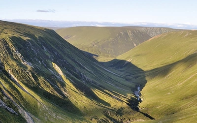
On approaching the South Downs, the rolling scarp and dip slopes that have for centuries inspired artists such as Ravilious and writers of the Bloomsbury group to wax lyrical, are exposed to illustrate the unreserved beauty of the national park.

Some 2km south-west the trail crosses the A22, followed by the B2124 at Holmes Hill. The road is fast and there are no crossing points here. Extra care is needed, especially as the road does not have particularly good visibility due to sweeping corners. Shortly after the crossing, you pass through the Mohair Centre, a farm-based forest school offering a range of outdoor educational learning opportunities.
The Vanguard Way continues south-west for 3km on a country lane, opening up expansive views of the South Downs. Berwick Station, situated on a main railway line, offers an inn with accommodation, as well as access to local towns for amenities and provisions. Shortly afterwards, the trail crosses over the A27 into the hamlet of Berwick with its Grade I-listed, 12th century church adorned with beautifully painted murals and 200-year-old inn, The Cricketers. From here, the village of Alfriston is a further 2.5km away, offering a further selection of pubs, accommodation and sights to visit, such as the Rathfinny vineyards.
Following the Vanguard and South Downs Way (SDW) National Trail for 2km south-east of Alfriston, you trail the Cuckmere River, to the small village of Litlington, where access to the Long Man Brewery can be gained. Their tasting room, visitor shop and brewery tours are a worthwhile stop to sample the local craft beer.
To the sea, and beyond!
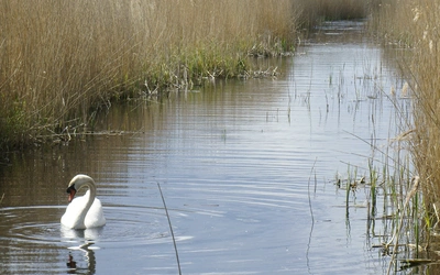
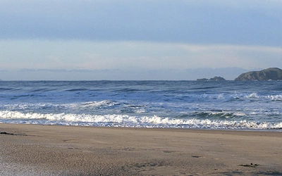
The Vanguard Way has a substantial number of stunning panoramic views and natural features to peruse along the way. Continuing on the SDW through West Dean, you reach the ultimate photo opportunity; the famous oxbow lakes and meanders of the Cuckmere with the far-reaching English Channel beyond. The reclaimed marshland is a worthwhile stop due to it being a haven for migratory birds, such as Canadian Geese, Golden Plovers, Dunlins and visiting Osprey on their long journey from Africa.
Descending to the bridge at Exceat you follow the fast-flowing tidal section of the river to the mouth, where one of the most iconic views of the South East of England emerges: the old Coastguard Cottages with the pristine chalk cliffs of the Seven Sisters in the background.
The Seven Sisters are receding at about 30-40cm a year on average. Rock falls have become more frequent in recent years, especially following heavy rain or rough seas. Seaford Head saw its last major rock fall in October 2018 when it is predicted that 50,000 tonnes of chalk were deposited into the sea. The Sussex Heritage Coast, established in 1973, is in the process of providing a framework to protect and conserve this stretch of coastline.
Ascending the path to Seaford Head Nature Reserve, you pass Hope Gap, famous for being the site of one of the first underwater telegraph cables to provide Anglo–International communications, and the last beach access point until you arrive in the seaside town of Seaford. This strip of coastline is an area filled with stunning scenery and steeped in history. Continuing along the headland to the seaside resort of Seaford, you pass by evidence of World War II relics, consisting of bunkers and pillboxes, alongside old trenches dug for training and protection during the war.
As you descend the golf course, onto the promenade at Seaford, you pass Martello Tower no.74 of 103, which now houses a local museum. These iconic maritime defences were built along the South East coast of England during the Napoleonic Wars, but only a few remain today. Seaford offers extensive opportunities for accommodation, amenities and rail transport.
The Vanguard Way meets and follows the Sussex Ouse Way from Bishopstone Station to pass through the old ruins of Tide Mills, the site of an 18th-century village consisting of a tidal-powered flour mill.
The area is steeped in history; in particular, it was used during World War II to practice beach landings in preparation for D-Day.
A guided walk can be followed through the extensive ruins to learn about the hamlet. The final walk into the town of Newhaven passes the harbour, offering a view across to the extensive 19th century cliff-top defence of Newhaven Fort. The fortification was the largest defensive works ever built in Sussex, with extensive buildings and tunnel systems throughout the cliff. The Vanguard Way finishes at the train station in the centre of the town.
Practicalities
The Vanguard Way has good transport options throughout the route. From train stations within a few miles of the trail at no less than six points throughout the 66 miles, alongside bus stops, there are many options to make the trail suit your needs. Accommodation, country pubs and local amenities are also regularly found along the route.
The Vanguards have produced an outstanding resource, including maps, detailed route descriptions as well as interest points along the trail including contributions on plants, wildlife and geology. Find out more on their website.