Alpine Pass Route Via Alpina 1
Swiss Via Alpina 1 (VA1) formally the Alpine Pass Route (APR) – is a hiking trail of over 350km across Switzerland, crossing high mountain passes through the eastern Alps, the Bernese Oberland and the Vaudoise on the northern side of the main Alpine chain to finish at Montreux on Lac Léman (Lake Geneva).
Cheese making and cowbells
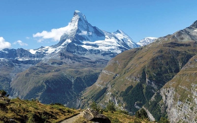
Imagine spending three weeks in the mountains traversing the Swiss Alps, with a central highlight of the Bernese Alps crowned with glaciers and summer snows, either side of which are mountains, valleys and lakes rarely visited by anyone but the alpine trekker. In the valleys, villages still centred around cheese making provide simple accommodation, and high above, farms and alpine huts offer refreshments amid the sound of cowbells.
This may sound like a tourist brochure, but the reality of the Swiss Via Alpina 1 is just that – many days where you rarely see another person, although there are also days, particularly in the Bernese Alps, where you become something of an object of interest among the tourists thronging the railway platform at Kleine Scheideg.
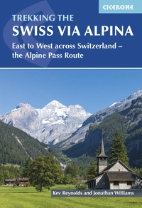
Trekking the Swiss Via Alpina
East to West across Switzerland - the Alpine Pass Route
£18.95
Guidebook to the Swiss Via Alpina, a 400km trek east-west across Switzerland, with options of detouring along the Alpine Pass Route. This demanding 3-week trek crosses 16 passes, including the 2778m Hohtürli, in a total of 19 stages from Sargans to Montreux, as well as a prologue stage from Liechtenstein. Requires good fitness and experience.
More information
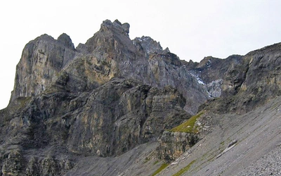
As the name implies, The Via Alpina 1 route involves crossing sixteen Alpine passes, and showcases some of the country's most breathtaking mountain landscapes. The route is not suitable for first time alpine trekkers, but best undertaken by those with some experience of Alpine trekking: it amasses over 20,000m of ascent and involves some steep and occasionally exposed sections, mainly on the three high passes – the Sefinenfurke (2612m), the Hohturli (2778m) and the Bunderschrinde (2385m).
The entire route can be completed in 2-3 weeks, although it is also possible to walk shorter sections; alternatively postbus, cable-car and rail connections could be used to allow for a tighter schedule if time is limited, and may be recommended in order to avoid one or two sections of walking through urban areas and busy roadside paths.
When to walk the Via Alpina 1
With a number of high or remote passes to cross, it’s important to choose the right time to tackle the route. With snow a potential hazard on some of these passes, in a ‘normal’ year the earliest time to consider setting out would be the beginning of July. Earlier than this and snow and possibly ice could create hazardous conditions on some of the highest and shadiest of places. Even in mid-July it’s not unusual to experience patches of soft melting snow; caution is advised if such conditions are encountered.
August is often damp, with sudden storms, while the first half of September is probably the optimum period in which to tackle the route. By late September autumn will be making itself felt, nights will sometimes have a light frost, and accommodation may be difficult to find in some of the smaller villages along the way.
Via Alpina 1 - suggested itineraries
The route has been structured to fit comfortably within three weeks, allowing for bad weather and one or more rest days. However, it is recognised that many walkers may not be able to allow a full three weeks. For those seeking to complete the route within two weeks, there are many opportunities using postbuses, cable cars and an occasional train to maintain a tighter schedule. As cable cars may only run during the peak summer periods, check in advance before relying on them. Much of the route is very well served by public transport and even if you found yourself apparently marooned at the head of a valley, it is possible to move on a stage by using buses.
Main transport options
- Prologue: Buses run between Sargans and Vaduz and Vaduz and Gaflei
- Stage 1: Buses run from Sargans to Weisstannen
- Stage 3: Cable car to Ampächli
- Stage 4: Cable car to Braunwald, postbuses to Urnerboden and Klausenpass
- Stage 5: Postbuses all along the route from Urnerboden to Altdorf
- Stage 6: Cable car to Brüsti
- Stage 7: Cable car to Trübsee and Jochpass, lift to Engstlenalp
- Stage 8: Buses from Engstlenalp to Meiringen, cable cars from Planplatten to Reuti and Meiringen
- Stage 9: Buses from Meiringen to Grindelwald, funicular to the Reichenbach Falls
- Stage 10: Trains over Kleine Scheidegg from Grindelwald to Lauterbrunnen
- Stage 11: Cable car from Lauterbrunnen to Grütschalp, train from Grütschalp to Mürren
- Stage 14: Cable cars up and down the Hahnenmoospass between Adelboden and Lenk
- Stage 15: Betelbahn cable car to Leiterli (off route)
- Stage 16: Cable car to Eggli
- Stage 17: Postbuses between L’Etivaz and Chateau d’Oex and trains to Rossinière,
- Stage 19: Train from Rochers de Naye to Montreux
The following suggestions are therefore given for breaking the route into separate walking holidays of a fortnight each.
- Sargans to Lauterbrunnen (Stages 1–10), with opportunities to take days off in Engelberg, Meiringen, Grindelwald and Lauterbrunnen to either recuperate or explore the surrounding area. Each resort has a selection of fine walks to enjoy.
- Lauterbrunnen to Montreux (Stages 11–18), with days off in Kandersteg, Adelboden, Gstaad, Lauenen or Gsteig. Each of these villages would repay a wider exploration of their surroundings.
- Altdorf to Gstaad (Stages 7–15), with days off in Grindelwald, Lauterbrunnen, Kandersteg, Adelboden, Lenk or Lauenen, Gstaad.
How hard is the Via Alpina 1?
Despite crossing many high passes, some of which are steep and rugged, the route demands no technical mountaineering skills of those who tackle it. However, there are occasional short, exposed sections (mostly safeguarded with fixed cable handrail), and a few places where cables and wooden steps aid the ascent to, or descent from, a pass where conditions dictate. Apart from these, the trails are mostly straightforward, albeit with several long stages to be faced.