Five of the best short walks along Hadrian's Wall: Roman forts, dramatic crags and Sycamore Gap
Hadrian's Wall stretches for approximately 73 miles (117km) across northern England, from the Solway Firth in Cumbria to Wallsend on Tyneside, and was designated a UNESCO World Heritage Site in 1987. Construction began in approximately 122 AD on the orders of Emperor Hadrian, and the Wall was intended to mark and defend the northern limit of Roman Britain. It remains the largest Roman monument in northern Europe. 15 Short Walks Hadrian's Wall by Mark Richards selects 15 of the best routes in this frontier landscape, each designed for straightforward enjoyment with distances ranging from 4 to 11km and most taking under three hours to complete. Here are five of the best to get you started. (Date updated: June 2026. Guidebook updated: February 2023.)
The five walks featured here span the full character of the Wall corridor: peaceful river valleys, showpiece stretches of Roman stone, working farmland, commanding ridge walks, and the World Heritage Site's most visited Roman forts. All are suitable for families and competent beginners, with no specialist equipment required. The Wall is walkable year-round, though April to October generally offers the driest ground and the best access to visitor facilities.
How to get to Hadrian's Wall?
The Wall corridor is served by two useful public transport options: the Tyne Valley Line railway runs regular services between Carlisle and Newcastle, with stations at Brampton, Haltwhistle, Bardon Mill, Hexham and Corbridge providing access to several walks; the AD122 seasonal bus service connects key Wall sites including, The Sill visitor centre and Housesteads. By road, the B6318 Military Road runs parallel to the Wall for much of its central section and is the most direct driving route. The nearest major airport is Newcastle (approximately 30 miles east of the central Wall). Check the bus timetables before you travel on the Go North East website.
If you're looking to walk the full path, Walking Hadrian's Wall Path and Hadrian's Wall Path Map Booklet are also available from Cicerone.
15 Short Walks Hadrian's Wall
£9.95
15 of the best short walks around Hadrian's Wall, including Sycamore Gap. Each walk comes with easy-to-read Ordnance Survey maps, clear route description and lots of images, plus information on beauty spots and refreshment stops. No challenging terrain or complicated navigation means walks can be enjoyed by everyone.
More information"The largest Roman archaeological feature in Britain, Hadrian’s Wall remains standing in some sections, and in many places the remnants of turrets and milecastles and the vallum are still visible. The remains of forts at Housesteads and Birdoswald and museums at Vindolanda and Chesters give a fascinating insight into life in this outpost of the Roman Empire."
— Mark Richards

Lanercost Priory
Summary: A gentle pastoral stroll connecting the River Irthing with the line of the Roman frontier, with time to explore the priory ruins
Start/finish: Picnic site by Lanercost Bridge (CA8 2HQ)
Time: 2hr 15min
Distance: 5km (3¼ miles)
Climb: 90m
This is the quietest and most contemplative of the five walks, rolling through pastoral countryside where the Roman frontier first makes itself known. The route connects the River Irthing with the line of the Wall before returning gently to Lanercost and the priory ruins that give the walk its name.
Lanercost Priory was founded in approximately 1169 by Robert de Vaux as an Augustinian house, and its builders made extensive use of Roman stone robbed from the nearby Wall. The result is a structure that carries the frontier's history in its very fabric. The nave remains roofed and is still in use for worship; the east end of the priory stands open to the sky, giving the ruins a particular atmospheric quality. Allow extra time to explore the site before or after the walk.
Refreshments are available at the Lanercost tea room and at a trailside cabin at Haytongate (honesty box). There are no public toilets on the route itself, though facilities are available beside Lanercost Bridge and within the Priory Garth (free). There is no bus service to the start; this walk requires a car.
Best time to visit: Spring and early summer, when the river meadows are at their greenest and the priory ruins are at their most peaceful before summer visitor numbers build. The walk is manageable year-round given its modest ascent.

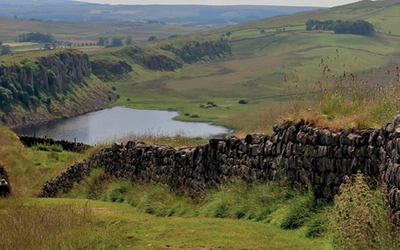
Birdoswald and Gilsland Spa
Summary: A rambling circuit taking in three outstanding stretches of Roman Wall, the fort at Birdoswald, a wooded gorge, and the best-preserved milecastle on the frontier
Start/finish: Gilsland (CA8 7AA)
Time: 3hr
Distance: 8.5km (5¼ miles)
Climb: 220m
This is the most substantial of the five walks, and arguably the richest in variety. Three extraordinary sections of standing Roman Wall, the fort at Birdoswald, a wander through a wooded gorge, and the remains of a Victorian spa resort are all threaded into a single route.
Birdoswald Roman Fort sits on a promontory above the Irthing Gorge and commands one of the finest stretches of the Wall. The route also visits Milecastle 48, known as King's Stables, which the guidebook describes as the best-preserved milecastle on the entire frontier. The return passes through what remains of the Victorian spa development at Gilsland, a reminder that this landscape has drawn visitors for reasons well beyond Roman archaeology.
The route crosses an active railway line. Take extra care at this point, particularly with children.
Refreshments are available at the Birdoswald Roman Fort cafe and at the House of Meg tea room in Gilsland. Toilets are located at the Birdoswald Roman site. Parking is available at the car park beside Gilsland Primary School (free). There are no bus services to this start point.
Best time to visit: Late spring through early autumn when the wooded gorge section is at its most atmospheric. The fort and Wall sections are striking in winter light, but check opening times for Birdoswald before visiting out of season on the English Heritage website.

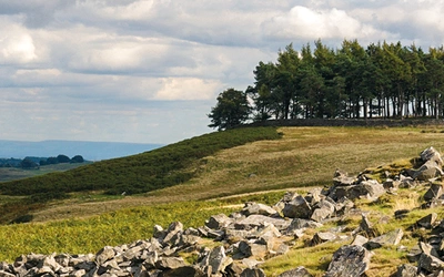
Sycamore Gap
Summary: An iconic section of the Whin Sill ridge walk, with thrilling ups and downs along the Wall and a return through open pasture
Start/finish: Steel Rigg car park (NE47 7AN)
Time: 1hr 45min
Distance: 5.5km (3½ miles)
Climb: 125m
The Sycamore Gap section of Hadrian's Wall is among the most photographed landscapes in northern England, and the dip in the Whin Sill ridge where a lone sycamore once stood remains one of the Wall's most visited and recognisable sites. The tree was felled in September 2023; the landscape itself, with its sharp ridge drops and long views north and south, retains all its dramatic character.
The walk delivers two distinct experiences. The outward leg follows the Wall closely along the Whin Sill, with a series of short, steep ascents and descents that give a genuine sense of the frontier's commanding position. The return heads south through open pasture, away from the main flow of Wall walkers, with wider views across the Tyne valley.
The Sill visitor centre, approximately 0.75km off route, provides the nearest café and toilets; there are no facilities on the walk itself. The AD122 bus serves The Sill, making a car-free visit straightforward in season. Parking is available at Steel Rigg National Park car park and at The Sill (both charge a fee).
Best time to visit: Year-round. The ridge is exposed in high wind or winter conditions, so dress accordingly. Early morning visits in summer offer the best light on the Wall and fewer other walkers on the ridge.

Vindolanda and Barcombe Hill
Summary: A car-free walk from Bardon Mill station up the Chainley Burn valley to Vindolanda Roman Fort, returning over the commanding viewpoint of Barcombe Hill
Start/finish: Bardon Mill railway station (NE47 7HU)
Time: 3hr
Distance: 7.5km (4¾ miles)
Climb: 320m
Arriving by train sets the tone for this walk, which feels genuinely unhurried from the start. From Bardon Mill station, the route follows the Chainley Burn valley up to Vindolanda. Excavations at Vindolanda have been ongoing since the 1970s and have produced an extraordinary archive of organic material, most notably the Vindolanda writing tablets: thin wooden letters and documents, dating from around 85 to 130 AD, that provide an unparalleled insight into daily life on the Roman frontier.
The return over Barcombe Hill adds a commanding viewpoint and a sense of the wider landscape before the descent to Thorngrafton Common and back to the station. At 320m of ascent, this is the most physically demanding of the five walks, though the gradient is steady rather than steep.
Entry to Vindolanda requires a fee; check current prices before visiting. Refreshments are available at the Bardon Mill tea room, the Bowes Hotel in the village, and at Vindolanda itself. The Tyne Valley Line and the 685 bus both run regular services between Carlisle and Newcastle, stopping at Bardon Mill.
Best time to visit: Spring through autumn for the best conditions on Barcombe Hill and the most active period for Vindolanda excavations. The site is open year-round but excavation activity is seasonal; check the Vindolanda Trust website for the current dig schedule.

Housesteads
Summary: A circuit around one of the Wall's showpiece forts, seen from all points of the compass, with an iconic milecastle and far-reaching views from the escarpment
Start/finish: Housesteads car park (NE47 6NN)
Time: 3hr
Distance: 7.5km (4¾ miles)
Climb: 160m
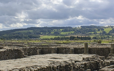
Housesteads Roman Fort sits midway along Hadrian's Wall, perched high on a dramatic escarpment with views north across open moorland and south across the Tyne valley. It is widely considered the most-complete Roman fort in Britain, and the approach from below gives a clear sense of why the site was chosen: the Wall here follows the Whin Sill's natural line, and the fort commands an enormous field of view in every direction.
This circuit approaches and departs Housesteads from multiple directions, placing the fort in its full landscape context rather than treating it as a simple destination. An iconic milecastle is included on the route. The guidebook notes that Walk 12 (Sewingshields Crags) offers a longer version of this circuit for those wanting to extend the day.
The National Trust visitor centre at the start of the walk provides a café and toilets. Light refreshments are also available in the English Heritage museum close to the fort itself. Entry to the fort requires a fee; the National Trust car park at Housesteads also charges. The AD122 bus serves Housesteads in season.
Best time to visit: Year-round. The escarpment is exposed, so wind and waterproofs are advisable in any season. Summer weekends can be busy; early morning or late afternoon visits in the shoulder season (May, June, September) offer the most rewarding experience of the site
15 Short Walks Hadrian's Wall
£9.95
15 of the best short walks around Hadrian's Wall, including Sycamore Gap. Each walk comes with easy-to-read Ordnance Survey maps, clear route description and lots of images, plus information on beauty spots and refreshment stops. No challenging terrain or complicated navigation means walks can be enjoyed by everyone.
More informationYou'll find all these routes (and 10 more) in our guide to 15 Short Walks Hadrian's Wall, which contains clear route descriptions, OS mapping, plus facilities, parking and highlights for every route. Each route has been carefully selected to showcase the best of the area. No challenging terrain or complicated navigation means the walks can be enjoyed by everyone.
About Mark Richards, author of 15 Short Walks Hadrian's Wall
Mark Richards began his walking writing career in 1973, with direct encouragement from Alfred Wainwright, producing his first guide to the Cotswold Way. He has since written extensively for Cicerone Press, including a three-part guide to the Peak District and his celebrated Lakeland Fellranger series of eight volumes covering the entire Lake District, completed in 2013. Now living in what was once the Barony of Gilsland, close to Hadrian's Wall, he brings decades of personal knowledge of this landscape to 15 Short Walks Hadrian's Wall, renewing a connection with the frontier first established when he wrote a guide to walking the Wall in 1993.