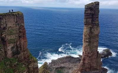
Great Mountain Days in Northern Scotland
Cicerone’s Director Joe Williams described some of the classic mountain walking routes in far north-west of Scotland, gives a few tips and suggestions, and urges everyone to make the journey north.
Our long-planned Swiss Alps trip in the summer of 2020 never materialised. No bother, we thought, Scotland has great mountains too – but this time let’s make sure we go somewhere new. In the short window of non-lockdown that summer we drove eight hours to Ullapool to experience the magic to be found in the far north-west of Scotland. In our hands were a few Cicerone books: Dan Bailey’s awesome Great Mountain Days in Scotland (a collection of classic long mountain adventures), Dan’s classic Scotland’s Mountain Ridges, Kirstie Shirra’s lovely book Scotland’s Best Small Mountains, and Chris Townsend’s bible for those who love hillwalking and mountaineering in the north: Scotland. What follows are a few of our highlights.
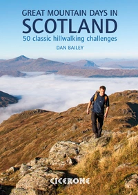
Great Mountain Days in Scotland
50 classic hillwalking challenges
£18.95
Inspirational guidebook to 50 challenging routes for mountaineers, scramblers, hillwalkers and fell runners, many long enough to backpack over 2 days, especially in winter (12 to 25 miles). A mix of classic routes and unsung gems across Scotland from Galloway to the Outer Hebrides in widely differing wild landscapes. With customised OS mapping.
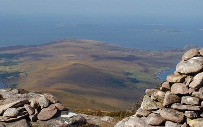
More informationStac Pollaidh (or Stac Polly)
The most famous mountain in Inverpolly and perhaps the whole of the north-west is an absolute cracker. For the dramatic climb and views from the top, it's well worth taking a copy of Scotland's Best Small Mountains and joining other hikers on this popular hill.
There’s a small car park at the base of the peak to the south, but this does fill up in busy periods. To allow a traverse of the mountain, we parked at Linneraineach and followed a good path up to the pass between Cul Beag and Stac Pollaidh. Here, wonderful views to the north opened up and we could see the sandstone giants rising out of the loch-spotted plateau below.
Turning towards Stac Pollaidh, a couple of kilometres of boggy, tussocky ground brought us to the ridge line. Sensing an opportunity for fun, we began scrambling on the ridge right away. Sections of fun Grade 1 and 2 terrain (mostly avoidable, apart from one obligatory step) led us up and down and around the various pinnacles as we made our way west to the highest point.
Stac Pollaidh is, from several angles, a beautiful and charismatic hill. It’s only 612m high, but it’s really worth doing. Plus it only takes a few hours. The views from the summit take in all of Assint, the famous peaks of Suilven and Cul Mor, as well as an outlook towards the coast and the charming Summer Isles.
Top tips:
- Take care to park responsibly
- As Stac Pollaidh is such a popular peak, it’s important to stick to the man-made paths wherever possible to avoid excessive erosion
- Try to enjoy as much of the scrambling on the ridge as possible!
Foinaven
Ever since seeing photos of Foinaven in Ken Wilson’s classic The Big Walks book, I had wanted to go to this hill. The high point of the ridge sits just a couple of metres below what’s required for Munro status, and it’s a few hundred metres further north than that most northerly of Munros, Ben Hope.
A study of the map and Great Mountain Days in Scotland showed that a circular route taking in Foinaven’s main ridge might prove challenging to accomplish. The six kilometres between the first and final summits appeared on the OS 1:25k map to hang in the air, with no paths to reach the start and none to take you down from the end. Dan’s book showed a great-looking route, but it started too far to the east for us. Instead we began our walk from the lonely Guilin House on the road between Rhiconich and Durness.
After a 10km jog down the new estate track in Strath Dionard, the track disappeared abruptly at a small shooting hut at Loch Dionard. Above us rose what looked to be some of the biggest cliffs in Britain: Creag Urbhard. Cloud smouldered around the crag, the white quartzite and epic atmosphere resembling the Dolomites more than Scotland. Within seconds of the track ending we were hopping from one peat hag to another, getting wetter and wetter feet. Looping south to An Dubh Loch, we finally turned north to begin the ridge at Bealach Horn, with a glimpse of the iconic and quartzite-skirted Arkle: a hill to come back for.
Sadly, at this moment the cloud set in and we were in the clag for the entire ridge traverse! The occasional parting of cloud gave us glimpses of glistening lochans below, but they was gone before we could get the camera out. The ridge was rough hillwalking, with a couple of steps where we put our poles away and used hands for balance.
The northern summit of Ceann Garbh was still seven kilometres from the car, and all the terrain was pathless. After the main bulk of the descent (taking us north-west to avoid the crags), the miles of bog and tussocks began.
Big mountain walking up here requires the mountaineer to be comfortable with there being no path to follow. If you do a certain amount of this stuff, the body becomes more efficient and economical on the terrain. It’s one of the appeals of the Highlands and far north in particular, the feeling of traversing remote and rugged ground where water, peat, long grass and rock all compete for supremacy.
Top tips:
- Be prepared for a long day out, whichever route you follow
- Go when there is good visibility. The hill is too special just to tick off without properly enjoying its spectacular setting
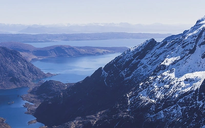
Canisp and Suilven
Dan Bailey gives us another big day here. First up the big and broad Canisp, then across to one of the most famous and iconic hills in all of Britain, Suilven. Approaching from the main road to the east, rather than the usual approach from the coast at Lochinver, the route takes a little while to get going. About five kilometres of ok path preceded a few more of bog and then a long slog up the south-east flank of Canisp. It’s relatively straightforward going, but a bit dull to be honest! The main perk of this ascent route is that the view across Loch na Gainimh to Suilven just gets better and better as you ascend. Suilven’s whaleback shape becomes clear and the views across the loch-studded lands and sandstone giants to the south do make it worthwhile.
The path up Canisp is tough to follow, but the going underfoot isn’t too rough to slow progress dramatically. Once the summit is crested, the route off to the north-west is on a good small trod, and the views to Suilven get even better. This lower mountain seems to have strong defences, and the way up it doesn’t reveal itself until you’re right on it. The ridge path then hits a straightforward estate track which leads down to a footbridge – approximately halfway on this walk (four hours for us).
Now the ascent of Suilven’s normal route begins. The OS maps strangely don’t show any paths going up Suilven, but I can promise you there is one! It’s an easy, but at times steep route to begin with, soon skirting the western side of Loch a’ Choire Dubh. This would make a magnificent camping spot, were it not for the plague of midges that greeted us as we rounded the waters. The path now turns towards a steep gully which leads all the way to the Bealach Mor; the path very much reminiscent of one over a high col in the Alps, tightly zig-zagging through improbable terrain.
We reached the col, and dumped packs to jog up the main summit to the north-west – what a view! Turning around, we could see the rest of the ridge to traverse, several summits rising and falling as we looked back inland. The traverse is mostly easy apart from two short spicy sections of Grade 3 scrambling (both of which coincided with a splurge of drizzle for us). But the rock is grippy sandstone so it feels quite secure. The final tower is best climbed on its left side, but we opted to bail out down a gully on the south and traverse this imposing final summit. All that remained was another long bog and tussock walk (seven kilometres) out to the path and another half hour back to the car.
Top tips:
- As usual, bring your gaiters and good waterproof boots if you’re walking. Runners should choose shoes with deep lugs for grip on mud, and make sure they are able to scramble confidently in them too.
- The views are so wonderful that it’s best to try to make time to stop, sit and take it all in from a few locations. To make that more comfortable, choose a good weather day and take some warm layers if there’s a chilly breeze.
Liathach and Coire Mhic Fhearchair
You hear a lot of things said about mighty Liathach, most surrounding the thought that it might be Scotland’s best mountain, and about the reputedly scary Am Fasarinin Pinnacles. Either way, it’s a hill that’s got to be climbed! Then there’s Coire Mhic Fhearchair, one of the most beautiful corries in Scotland under Beinn Eighe’s Triple Buttress, also a place you have to visit.
The route in Great Mountain Days in Scotland is a biggie: Dan casually suggests we just do a quick traverse of Beinn Alligin (!) after Liathach’s traverse before walking back to the car. After several big mountain day back to back this sounded a bit much for us so we formed an alternative plan: walk in towards Coire Mhic Fhearchair with camping kit, stash the overnight gear high in Choire Dubh Mor, traverse Liathach, then walk round the back of the mountain, picking up the camping gear before overnighting in the choire.
Luckily for us, the weather was really on our side: bright sunshine and the lightest of breezes. That really helped elevate a truly brilliant mountain day. Liathach lived up to its reputation as one of the great Scottish hills, but, for us, the Am Fasarinen Pinnacles proved very enjoyable scrambling on excellent Torridonian sandstone. They’re only Grade 2, and the hard bits are bypassable. Doing the traverse is surely better than making two separate trips to the Munro summits: the high-level walk is magnificent, with Glen Torridon down on your left and the rest of the Torridonian giants laid out to the front, right and rear.
The long walk round the back mostly lived up to its reputation as one of Scotland’s finest low-level routes, but I might say it went on a little too long for our weary legs. Collecting our camping equipment, we looped around the front of Sail Mhor to be presented with the immense scene of the Triple Buttress rising above Loch Coire Mhic Fhearchair as dusk set in. The beautiful sunset was only marred by – yes, you guessed it – a midge attack.
Top tips:
- Ask a local how to pronounce Liathach – it might surprise you!
- Have a go at the traverse as it’s not too hard
- Pay very close attention to finding the small path up Stuc a Choire Dhuibh Bhig when you break off from the main route to Coire Mhic Fhearchair.
Beinn Alligin
Another of Torridon’s most famous hills, Beinn Alligin is very shapely, and a true walkers’ mountain. In fact, its name means Jewelled Mountain. The scrambling on the traverse barely registers as Grade 1 so it’s quite accessible for a lot of walkers.
As a horseshoe, it can be done in each direction. We went clockwise (for no particular reason), but anti-clockwise may have benefits, especially in taking the steep step halfway up Na Rathanan in ascent rather than descent. So, first tackling Tom na Gruagaich, the climb goes fairly quickly, especially given how direct the route is (and how good the footpath is – not always a given in these parts). Sadly, the cloud enveloped us around the 800m mark, and stayed that way for the whole traverse. Annoyingly, the clouds then totally disappeared from the mountain when we had got back to the car: we nearly turned right around to do the mountain again!
The walking is rocky, but relatively easy until after Sgurr Mor and the ‘Horns’. At this point there’s bits of scrambling that can’t be easily avoided, but it’s pretty straightforward. Interestingly, for linking two Munro summits on a classic mountain, the traverse of Beinn Alligin isn’t too time-consuming: four and a half hours for us at a steady pace.
Top tips:
- Get to the parking area early as it’s a popular hill
- It’s probably better to go anti-clockwise
- As it can be done in a half day, Beinn Alligin provides a great route if you need to travel that day too.