Italy's Grande Traversata delle Alpi: a complete planning guide
The Grande Traversata delle Alpi (GTA) is one of the great alpine treks: 809km and over 57,000m of ascent and descent, crossing Italy from the Swiss border in the high Alps all the way to the Mediterranean Sea. The route traverses five distinct alpine regions — the Lepontine, Pennine, Graian, Cottian, and Maritime Alps — passing beneath Monte Rosa, Rocciamelone, Rocca la Meja, Monviso, and the epic spires of the Argentera. Quieter and wilder than its better-known French counterparts in the Ecrins or the Vanoise, the GTA runs through a part of the Alps where transhumance still shapes the seasons, ibex clash horns on the high ridges, and village life still gathers around the family-run posto tappa. David Jordan's guidebook describes the full route in 55 stages across three sections, the first English-language guide to present a single continuous route from border to sea. (Last updated: June 2026 · Guidebook edition: 1st edition, 2023)
Italy's Grande Traversata delle Alpi, quick facts:
- Location: Western Italian Alps, from the Swiss border (Nufenen Pass) to Ventimiglia on the Mediterranean coast
- Total distance: 809km (503 miles)
- Total ascent: approximately 57,000m; total descent approximately 58,000m
- Number of stages: 55, organised in 3 sections (north, central, south)
- Stage distance range: 7km to 26km
- Suggested duration: Approximately 345 hours of walking; commonly split into three 3-week trips, or two halves divided at Susa (almost exactly 400km from either end)
- Alpine regions crossed: Lepontine, Pennine, Graian, Cottian, and Maritime Alps
- Difficulty: No technical skills required; some steep, exposed sections protected by chains or fixed ropes; suitable for any reasonably fit walker
- Navigation: Red and white waymarks (yellow in Parco Nazionale Gran Paradiso); National Geographic 1:25,000 map booklets recommended (North, Central, South)
- Best season: June to September; snow can remain on high passes into mid-June; autumn storms begin by late September
- Getting there: Fly to Milan (or Turin); rail and Postbus connections to Nufenen Pass via Airolo
- Getting back: Train from Ventimiglia to Nice (1hr) or Genoa (2hr)
- Guidebook:Italy's Grande Traversata delle Alpi by David Jordan, 1st edition
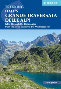
Italy's Grande Traversata delle Alpi
GTA: Through the Italian Alps from the Swiss border to the Mediterranean
£18.95
A guidebook to the 809km Grande Traversata delle Alpi trek through the western Italian Alps traversing the Lepontine, Pennine, Graian, Cottian and Maritime Alps to finish at Ventimiglia. The guide splits the route into 3 sections with 55 day stages. A good level of fitness is required to tackle the route as it contains nearly 60,000m of ascent.
More informationWhat is the Grande Traversata delle Alpi?
The Grande Traversata delle Alpi is a long-distance trek of 809km across the western Italian Alps, from the Nufenen Pass on the Swiss border to Ventimiglia on the Mediterranean. Devised in the 1970s and inspired by the success of the French GR5, the route was originally conceived south to north and ran a shorter course between Viozene and Molini di Calasca. Over the decades it has been extended at both ends, and most walkers today recognise the GTA as the full border-to-sea route, walked north to south.
What distinguishes the GTA from the more famous long-distance routes on the French side of the Alps — the Ecrins, the Vanoise, the Queyras — is its quietness. There are no large ski resorts, no major hotel chains, and little of the polished tourist infrastructure found elsewhere in the Alps. Life in these valleys continues much as it always has: transhumance still moves great flocks of sheep up to alpine pastures as the snow recedes, Maremma sheepdogs still guard against wolves, and the small village posto tappa — typically a family-run bar, restaurant, and lodging — remains the social hub of mountain life.
The route's survival owes much to German cultural geographer Werner Bätzing, whose decades of research and definitive two-volume German-language guidebooks kept the GTA alive after its initial 1970s momentum faded. The first English-language guide was published by Cicerone in 2005, written by Gillian Price. David Jordan's guidebook is a full rewrite reflecting the route's extension and the modern convention of walking north to south, border to sea. For complete stage descriptions and accommodation listings for all 55 stages, see the Cicerone Italy's Grande Traversata delle Alpi guidebook.
The three sections and 55 stages at a glance
The route is presented in three sections — north, central, and south — corresponding to the coverage of the three National Geographic 1:25,000 map booklets. The northern section comprises 17 stages and is around 240km; the central and southern sections each comprise 19 stages and are around 280km. Susa, almost exactly 400km from either end with excellent transport links, is the natural midpoint for those splitting the trek into two.
| Section | Stages | Distance | Total ascent |
| North (Nufenen Pass to S. di Oropa/Piamprato) | 1–19 | ~240km | ~17,000m |
| Central (Piamprato to Chiappera) | 20–38 | ~280km | ~23,000m |
| South (Chiappera to Ventimiglia) | 39–55 | ~280km | ~17,000m |
The northern section (Stages 1–19) begins at the Nufenen Pass on the Swiss border and crosses the Lepontine and Pennine Alps. The route passes through the Alpe Devero and Alpe Veglia National Park, where turquoise lakes and towering peaks feel almost Swiss, before dropping through the Valle Anzasca and Valsesia beneath the towering presence of Monte Rosa. Stage 23 (San Lorenzo to Ceresole Reale, 26km, 10hr 45min) is the longest single stage of the entire GTA.
The central section (Stages 20–38) crosses the Graian and Cottian Alps, touching the corner of the Parco Nazionale Gran Paradiso before turning more definitively south as Monte Viso comes into view. This section includes the historic fortifications at Fenestrelle, the largest alpine fortification in Europe, and the Waldensian valleys around Balsiglia, with their long history of religious persecution and resistance. The section has the steepest overall profile of the three, with over 23,000m of ascent.
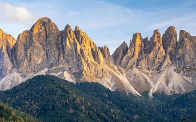
The southern section (Stages 39–55) enters the Maritime Alps and the Argentera, a landscape that surprises many walkers with its resemblance to the Dolomites. The route touches the French border repeatedly around the Colle di Tenda before descending through diminishing altitudes to the final ridge above Ventimiglia, finishing with a short walk down to the beach and the Mediterranean Sea.

Where can I join or leave the GTA?
The GTA's stages and section ends have been chosen to make transport in and out straightforward, and the route does not need to be walked in a single continuous trip.
Splitting the route into thirds is the structure used in the guidebook: roughly three weeks each for the north, central, and south sections, with good transport and resupply options at each section end.
Splitting the route into halves at Susa is a natural alternative: Susa lies almost exactly 400km from either end of the route and has excellent facilities and transport connections, making it a logical midpoint for those tackling the GTA over two separate trips.
Thru-hiking the full route in one season takes around 345 hours of walking spread across 55 stages. Section ends still make good places to resupply, do laundry, and take stock even for those walking continuously.
Stages are designed around available accommodation rather than as rigid daily targets — many can be combined, and some longer stages can be split using accommodation options partway through, which are listed in the guidebook alongside those at stage ends.
What is the terrain like on the GTA?
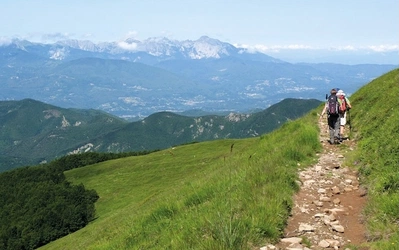
The GTA runs primarily north to south, but the alpine ridges it crosses run broadly east to west — meaning the trail crosses ridge after ridge, with significant daily ascent and descent as a result. A typical day involves a long climb, often up to 1000m, to an alpine pass, followed by a descent to a posto tappa in a small hamlet, or several climbs and descents to a mountain rifugio.
No technical climbing skills are required anywhere on the route. Some exposed or eroded sections are protected with ropes or chains, and a small number of steep sections are fine in good weather but risky when wet — in these cases the guidebook always identifies an alternative, safer path. Trail surfaces vary enormously: short stretches of tarmac, faint tracks across scree navigated by cairns, shepherd tracks, old pilgrimage routes, military roads, and — one of the particular delights of the GTA — the mulattiera, ancient cobbled mule trade routes that wind through forests and over high passes with switchbacks designed to ease the load for pack animals centuries ago.
The higher passes on the GTA exceed 2500m, while typical overnight accommodation sits around 1000m — illustrating just how much daily climbing the route demands. Despite this, the guidebook is clear that hiking the GTA is within reach of any average, reasonably fit walker, and that walkers will become noticeably fitter as the trek progresses.
When is the best time to walk the GTA?
The GTA is best walked between June and September.
- Early to mid-June can still carry snow on high ground, with traces remaining on the highest passes even later in a typical year.
- July and August are the most reliable months for clear high passes, though the middle two weeks of August — when most Italians take their summer holiday — bring significantly busier trails and accommodation that needs booking well in advance. Weekends either side of this period can also be busy, especially where vehicle access is easier.
- September remains a good option into the early part of the month, but by late September autumn storms are beginning and rain becomes more frequent.
Outside the June–September window, accommodation options away from the larger villages become severely limited, as many small operators only open for the summer season. Trail conditions also vary year to year — a wet spell can cause significant erosion, leading to temporary re-routes in places.

How do I get to and from the GTA?
Getting to the start (Nufenen Pass): Flying to Milan is the most efficient option for most UK travellers, with excellent onward connections — Milan Malpensa to Milan Central Station takes just 51 minutes by direct train. Turin is geographically closer to much of the route but has more limited direct UK flight options. From Milan or Turin, rail connections lead north to Switzerland; from Zurich or Milan, train to Airolo connects with the Postbus to Nufenen Pass.
Getting home from the end (Ventimiglia): The finish at Ventimiglia is well served by rail. Nice is an easy one-hour train journey west across the French border; Genoa is around two hours east along the Italian coast. Both have international airports.
For thru-hikers completing the route in a single season, separating outward and return bookings — rather than booking a fixed return flight in advance — gives valuable flexibility, since the exact finish date is hard to predict precisely in advance.
Travelling within Italy: Trenitalia (trenitalia.com) and its English-language app cover long-distance and regional trains; regional trains do not require advance booking. Italiarail.com offers English place names for an additional booking fee. Buses connecting trailheads to the rail network are regionally organised but reliable — Rome2Rio (rome2rio.com) is a useful tool for finding bus options in advance. Remember to validate any paper ticket before boarding.
Where do trekkers stay on the GTA?
Accommodation on the GTA ranges from the simplest self-catered bivacco shelters to small boutique hotels, with most nights spent in one of several characteristic types:
- Posto tappa — literally a 'stopping place', usually a small, family-run bar, restaurant, and lodging that forms the social hub of village life
- Agriturismo — farms or local dairy producers who open their homes to walkers, often offering rich conversation and local history alongside a bed
- Albergo — small, usually family-owned hotels found in larger villages, offering more choice
- Rifugio — mountain refuges in the higher, more remote stretches, typically run by the Club Alpino Italiano (CAI) or privately, with dormitories or shared rooms
CAI members and members of affiliated clubs such as the British Mountaineering Council (BMC) receive accommodation discounts at rifugios. Wild camping is technically prohibited in Italy, though in practice the situation mirrors England: discretion, distance from farms and villages, and strict leave-no-trace principles are expected. Always ask permission at a rifugio if camping nearby — many hosts are happy to allow this in exchange for a meal purchase.
Booking far ahead is generally unnecessary outside the peak two weeks of August, though a courtesy call the night before — especially if dinner is wanted — is expected practice, particularly where mobile signal is unreliable. Expect to pay around €50–60 for half board (mezza pensione) at most providers.
What is the food and culture like along the GTA?
The GTA passes through the birthplace of the Slow Food Movement, and food is one of the genuine highlights of the trek. Meals are social occasions rather than functional refuelling stops, typically following the classic Italian structure of antipasti, primo piatto (often pasta), secondo piatto (usually meat with vegetables), and dolce. The region is also home to the Nebbiolo grape, source of Barolo and Barbaresco — among the finest wines most walkers will ever drink trailside.
Breakfast in Italy, and especially in rifugios where fresh supplies arrive only periodically by helicopter or mule, tends to be small and sweet: cappuccino or latte, perhaps a slice of cake or a croissant, and packaged mini toasts. Walkers used to a heartier start to the day should consider carrying their own supplemental breakfast supplies.
Beyond food, the route carries a strong sense of layered history: Roman-era military roads, the vast 17th-century fortifications at Fenestrelle (the largest alpine fortification in Europe), and the story of the Waldensians, a persecuted Protestant minority whose history is told at museums on the approach to Alagna Valsesia (Stage 12) and in the village of Balsiglia (Stage 31), where they fought a heroic, outnumbered battle and made a near-miraculous escape.

What are the highlights of the GTA?
- Alpe Devero and Alpe Veglia National Park (Stages 2–4) offers turquoise lakes and towering peaks with a distinctly Swiss character, the gentlest introduction to the trek's high mountain scenery.
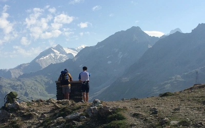
- Monte Rosa dominates the view from numerous passes and high points through the Valle Anzasca and Valsesia (around Stages 10–13), one of the most consistently impressive mountain backdrops on the entire route.
- The corner of the Parco Nazionale Gran Paradiso (around Stage 23) is the only section of the GTA marked with yellow rather than red and white waymarks, leading to Lago di Ceresole and the turn south towards Monte Viso.
- Fenestrelle Fort (around Stage 30) is the largest alpine fortification in Europe, dating from 1690 and sometimes called the Great Wall of Europe — an extraordinary feat of military engineering encountered mid-trek.
- The Argentera massif (Stages 49–53) surprises many walkers with scenery reminiscent of the Dolomites, a dramatic and unexpected character shift in the far south of the route.
- The descent to Ventimiglia (Stage 55) is the emotional climax of the trek: the route resolutely holds the high ground until the very last ridge, descending by sea cliff to a short final walk to the beach and the Mediterranean — the only place left to walk being into the sea itself.
What should I pack for the GTA?
Because accommodation and meals are available daily along almost the entire route, a large backpack is unnecessary — a rucksack of around 40 litres with a waistbelt is generally sufficient. Essential items include comfortable, broken-in footwear; a waterproof jacket and trousers; insulating layers (synthetic rather than down, given the damp climate); a warm hat and gloves even in summer; sun protection; trekking poles (strongly recommended for both ascent and descent); a sheet sleeping bag or liner for use in huts; and a basic first aid kit.
A paper map is recommended as a backup to GPS or phone navigation, along with a compass — no advanced skills are needed, simply the ability to confirm a stated direction of travel. A personal locator beacon is worth considering given the long stretches without reliable mobile signal.
Is the GTA safe and how difficult is the navigation?
No technical climbing skills are required anywhere on the GTA, but the route does cross many high passes, some steep and rugged, requiring sure-footedness. Exposed sections are generally protected with chains, fixed cables, or ropes; where a section becomes genuinely dangerous in poor weather, an alternative route is always available, even if it adds distance.
Waymarking is the standard Italian red-and-white system used on walking routes throughout the country (not exclusive to the GTA), supplemented with state and timing information, and occasionally explicit 'GTA' labelling. Because the GTA was originally conceived as a network of route options rather than one single definitive line, walkers will occasionally encounter signs that appear to conflict — the guidebook's single continuous route, GPX tracks, and recommended National Geographic mapping are designed to remove this ambiguity. Mobile phone signal cannot be relied upon for long stretches, sometimes for several days at a time.
Plan your trek with the Cicerone guidebook
The Cicerone Italy's Grande Traversata delle Alpi guidebook by David Jordan contains everything you need to plan and complete the full 809km route.
- 55 stage descriptions across three sections (north, central, south), each with a 1:100,000 stage map, route profile, and detailed waypoint-by-waypoint description
- Route summary table listing all 55 stages by distance, time, ascent, descent, and high/low points
- Section introductions with full transport information for accessing or leaving each section start and end point
- Accommodation listings at stage ends and partway through stages, with type, contact details, and address for every option
- Free GPX files for every stage
- Comprehensive planning sections covering history, plants and flowers, wildlife, language, what to take, and preparation and safety
- Glossary (Appendix A) of useful Italian words and phrases for trail life and booking accommodation
- Companion app access, currently discounted to £4.50 (from £9.00)
Available as a printed guidebook (£18.95) or digital eBook (£18.95).
Italy's Grande Traversata delle Alpi
GTA: Through the Italian Alps from the Swiss border to the Mediterranean
£18.95
A guidebook to the 809km Grande Traversata delle Alpi trek through the western Italian Alps traversing the Lepontine, Pennine, Graian, Cottian and Maritime Alps to finish at Ventimiglia. The guide splits the route into 3 sections with 55 day stages. A good level of fitness is required to tackle the route as it contains nearly 60,000m of ascent.
More informationAbout David Jordan, guidebook author
David Jordan has been hiking, trekking, and camping since a young age, with his earliest memories of walking adventures coming from family holidays with a Kodak Instamatic camera and notebook. He has hiked and camped extensively across much of the higher ground of the UK, Europe, Norway, and the US. His long-distance walking career began with a circuit of the Tour du Mont Blanc in 1992, continued through sections of the Appalachian Trail, and led to a full thru-hike of the Pacific Crest Trail in 2016. He returned to the Alps to spend four years researching and exploring the Grande Traversata delle Alpi for this guidebook. In 2023 David hiked the PCT for a second time, becoming one of fewer than 200 people to have thru-hiked the trail more than once. He lives on the Arnside and Silverdale peninsula, on the edge of the English Lake District, with his wife and dog.