Trekking in the Apennines: a complete planning guide
The Apennines, the rugged spine that runs the length of the Italian peninsula, are without doubt Italy's best-kept walking secret. While the Alps draw the crowds, this elongated mountain chain offers thousands of kilometres of marked trails over panoramic ridges and through vast forested valleys, touching quiet rural communities little affected by mass tourism. The Grande Escursione Appenninica (GEA) is the classic long-distance route through the central and northern Apennines: 23 days, just over 400km, climbing between 400m and 2054m above sea level. Gillian Price's guidebook describes the full trek from the Tuscany–Umbria border to the edge of Liguria, crossing two national parks, touching the homeland of Saint Francis, and finishing within reach of the sea. (Last updated: June 2026 · Guidebook edition: 2nd edition, 2024)
Trekking in the Apennines, quick facts:
- Location: Central and northern Apennines, Italy — Tuscany, Umbria, Emilia-Romagna, and the edge of Liguria
- Total distance: 402.6km (249 miles)
- Number of stages: 23
- Stage distance range: 8km to 25km
- Total altitude range: 400m to 2054m above sea level
- Highest point: Monte Prado, 2054m (Stage 18), the highest peak in Tuscany and on the GEA
- Difficulty: Grade 1 (straightforward) to Grade 3 (strenuous, exposed sections); most of the route Grade 1–2 to 2
- Terrain: Forestry tracks, broad paths, open windswept ridges, beech and chestnut woodland, occasional brief exposed crest sections
- National parks crossed: Parco Nazionale delle Foreste Casentinesi; Parco Nazionale dell'Appennino Tosco-Emiliano
- Navigation: CAI red/white waymarks with the GEA logo; Kompass 1:50,000 maps (4 sheets) recommended
- Best season: April to October; July–August most reliable for high-altitude refuges; Stages 1–13 walkable spring to autumn, Stages 14–23 limited to midsummer
- Getting there: Fly to Ancona, Pescara, Pisa, or Rome (start); Genoa or Bologna convenient for the finish
- Guidebook:Trekking in the Apennines by Gillian Price, 2nd edition
Trekking in the Apennines
The Grande Escursione Appenninica
£14.95
Guidebook to the Grand Apennines Trek, or Grande Escursione Appenninica (GEA). Through Tuscany and Emilia-Romagna and 2 national parks, this 400km trail takes 23 days to complete, exploring the mountains, forests and hills of central Italy. Suitable for a range of walkers, it can be split into shorter sections or day walks if needed.
More information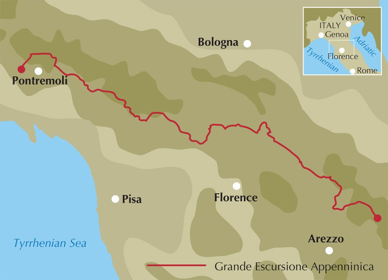
What is the Grande Escursione Appenninica?
The Grande Escursione Appenninica, known as the GEA, is a 23-day, 402.6km long-distance trek through the central and northern Apennines — roughly a third of the entire 1400km Apennine chain that forms the spine of the Italian peninsula. Conceived in the 1980s by Florentine walking enthusiasts Alfonso Bietolini and Gianfranco Bracci, the route starts at Bocca Trabaria on the Tuscany–Umbria border, progresses northwest with several forays into Emilia-Romagna, and finishes at Passo Due Santi on the edge of Liguria.
The walking is straightforward by alpine standards: paths, forestry tracks, and lanes with constant waymarking, suitable for a broad range of walkers. The terrain ranges from rocky open ridges and windswept crests to thick beech and chestnut woodland, where layers of leaf litter cushion tired feet. A few brief sections in the northern stages cross exposed crest, though these are mostly avoidable.
The GEA crosses two national parks. The southern stages traverse the 364 sq km Parco Nazionale delle Foreste Casentinesi, with magnificent ancient chestnut, fir, and beech woods nurtured by monks over centuries, and pathways once walked by Saint Francis. The more elevated northern stages enter the 240 sq km Parco Nazionale dell'Appennino Tosco-Emiliano, dotted with glacial lakes. For complete stage descriptions, maps, and accommodation listings for all 23 stages, see the Cicerone Trekking in the Apennines guidebook.
The 23 stages at a glance
Each stage corresponds to a single day's walking, though stages can be combined or split depending on personal pace and the accommodation listed partway through many of them.
| Stages | Distance range | Time range | Grades |
|---|---|---|---|
| 1–9 (Bocca Trabaria to Passo del Giogo) | 8–23.5km | 2hr 10min–7hr | 1–2 to 2 |
| 10–13 (Passo del Giogo to Pracchia) | 13.5–24.2km | 4hr 30min–6hr 50min | 2 to 2–3 |
| 14–17 (Pracchia to Lago Santo Modenese to Passo delle Radici) | 15.5–16km | 5hr 30min–7hr | 2 to 2–3 |
| 18–23 (Passo delle Radici to Passo Due Santi) | 11.5–25km | 4hr 10min–7hr 45min | 2 to 2–3 |
Stages 1–9 form the gentlest and most accessible part of the trek, crossing the Foreste Casentinesi National Park and following paths once walked by Saint Francis. Highlights include the sanctuary at La Verna (Stage 3) and the monastery at Camaldoli (Stage 5). This section is suitable from spring through to autumn.
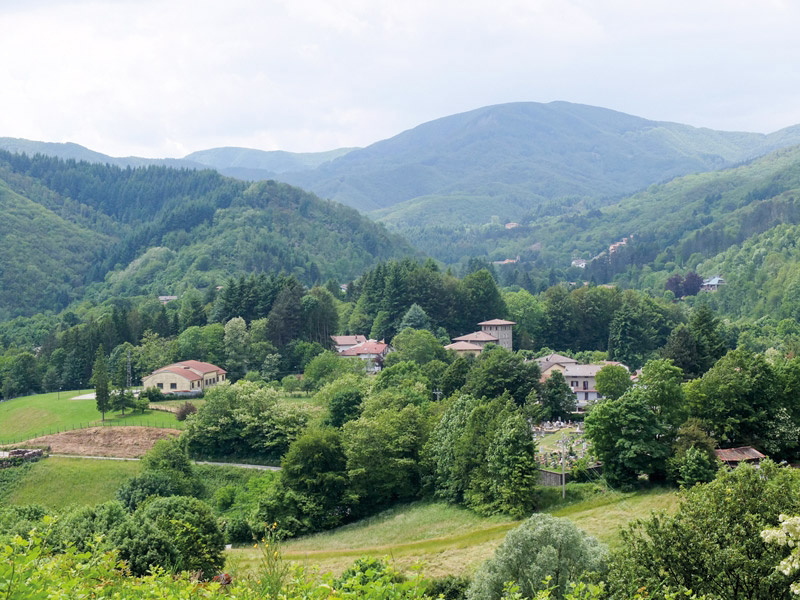
Stages 10–13 cross into Emilia-Romagna with marked changes in accent and cuisine, including the poignant German war cemetery at Passo della Futa (Stage 10) and the shrine-studded hills around Montepiano (Stages 12–13).
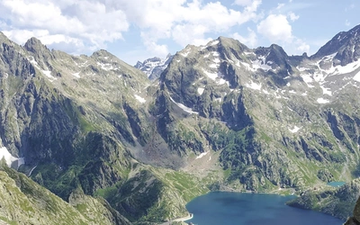
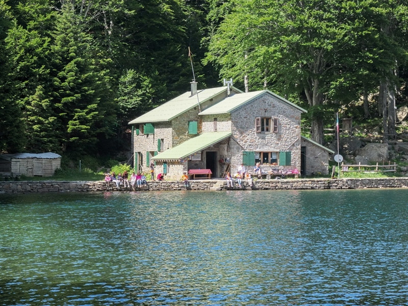
Stages 14–17 climb into the higher northern Apennines, taking in Lago Scaffaiolo, the peaks of Corno alle Scale and Libro Aperto, and the popular lake resort of Lago Santo Modenese. From here on, accommodation is more limited to the midsummer season as the higher refuges only open from June.
Stages 18–23 form the highest and most spectacular section, crossing Monte Prado — the highest peak in Tuscany and on the GEA at 2054m — and a sequence of high passes including Passo Pradarena and Passo della Cisa, before descending towards Passo Due Santi and the edge of Liguria.
How long does the GEA take, and can I walk just part of it?
The full GEA takes 23 days. However, the route was designed with flexibility in mind: almost every day touches a road pass or village served by local transport, allowing walkers to start or stop at will to fit personal holiday requirements. The guidebook highlights a selection of shorter sections for those without 23 days available, each beginning and ending at a point served by public transport:
- 1 day: Badia Prataglia–Camaldoli (Stage 5); Passo del Giogo–Passo della Futa (Stage 10, ending at a WWII German war cemetery)
- 1–2 days: Montepiano–Rifugio Pacini–Cantagallo (Stages 12–13), a shrine-studded route through rolling green hills, especially lovely in spring
- 2 days: Badia Prataglia–Rifugio Città di Forlì–Passo del Muraglione (Stages 5–6), a rewarding mini-trek through the Casentino National Park; Pracchia–Lago Scaffaiolo–Abetone (Stages 14–15), an exhilarating stretch with deer-rich woodland and open ridges; Boscolungo (Abetone)–Lago Santo Modenese–San Pellegrino in Alpe (Stages 16–17); Prato Spilla–Lago Santo Parmense–Passo della Cisa (Stages 21–22), with sweeping ridge views and detours to attractive cirque lakes
- 3 days: Passo delle Radici–Passo Pradarena–Passo del Cerreto (Stages 18–19), taking in Monte Prado, the highest peak in Tuscany and the GEA, plus prime bilberry picking
How difficult is the GEA?
The guidebook grades each stage on a three-point scale. Grade 1 is straightforward walking with little ascent on broad, clear paths, suitable for first-timers (equivalent to Italian CAI grade T, turistico). Grade 2 involves moderate difficulty over mountainous terrain or considerable height gain (CAI grade E, escursionistico). Grade 3 covers strenuous routes with exposed stretches, where basic navigation skills are preferable (CAI grade EE, escursionistico esperto).
The majority of stages fall at Grade 2, with the highest and most exposed sections — particularly Stages 14 to 22 in the northern Apennines — reaching Grade 2–3. A walker of average fitness can expect to cover around 300m of ascent per hour, though this varies with terrain and gradient. Walking times given in the guidebook are approximate and exclude rest stops, so adding a couple of extra hours to any stage is sensible, particularly in midsummer when the bilberry harvest along the trail provides an irresistible distraction.
Weather can transform difficulty significantly: dense fog can roll in suddenly, and winds exceeding 100kph are not uncommon on exposed ridge sections. The guidebook recommends taking weather forecasts seriously and having an escape route in mind on any ridge stage.
When is the best time to walk the GEA?
The GEA was originally designed as a summer route, and July–August remains the most reliable period, with stable conditions and all accommodation and transport operating. That said, any time from April to October is both possible and recommended, each season offering something different.
- Spring (April–May) brings fresh, crisp air ahead of summer's mugginess and is an excellent time for wildlife watching, since the lack of foliage makes animals easier to spot. The main disadvantage is potential snow cover above 1500m if winter snowfall arrived late.
- May typically offers near-perfect walking weather: neither too hot nor too cold, with some rain to be expected.
- Midsummer (July–August) is the most dependable period for the higher northern stages, since most high-altitude refuges only open from June onwards.
- Late September–October is glorious for beech woodland at its russet best, though low cloud and mist become more frequent, and amateur bird hunters may be encountered in hides on ridges and clearings (a polite 'Buon giorno' is recommended courtesy).
A useful rule of thumb: Stages 1–13 are walkable from spring through to autumn, while Stages 14–23 are effectively limited to midsummer due to refuge opening dates. Walking later than October significantly increases the chance of poor weather and hotel closures, and the end of Daylight Saving Time shortens the available daylight for longer stages.
Where do trekkers stay on the GEA?
Roughly two-thirds of GEA stages end at a hotel, and the remaining third at a mountain refuge (rifugio). All accommodation has a restaurant, and many offer mezza pensione (half board) at around €40–60 per person, including overnight stay, breakfast, and a three-course dinner.
Rifugi are CAI-run hostel-like huts, open to everyone, reachable only on foot, staffed by a custodian and offering dormitory bunks, café and restaurant service, and usually hot showers. CAI cardholders and members of reciprocal overseas alpine clubs receive discounted rates; UK residents can join CAI or the Austrian Alpine Club for this benefit.
Posto tappa (the Italian equivalent of a French gîte d'étape) appear only twice on the route, at Stages 7 and 13, offering dorm accommodation with cooking facilities. Two unmanned, basic bivacco huts are also on the route, always open but requiring full self-sufficiency in food, sleeping bag, and possibly water. A foresteria refers to monastery guest quarters, usually now to hotel standard.
Always phone ahead to book, even at short notice — don't arrive unannounced. Mid-August is peak Italian holiday season and demands advance booking, as does any rifugio on a summer Saturday night, when local walking groups often fill capacity.
Camping is tolerated for a single night within the designated national park areas (Stages 4–6 and 18–22), and there are designated campsites near Badia Prataglia, Passo della Futa, and Rigoso (just off-route). Combining guesthouses with occasional camping is one of the most enjoyable ways to walk the GEA, with groceries available in villages and water along the route.
Getting to and from the GEA
Getting to the start (Bocca Trabaria): The nearest useful airports are Ancona, Pescara, Pisa, and Rome, all with onward bus and rail links. The Baschetti bus service runs between Sansepolcro and Pesaro and stops at Bocca Trabaria. Pesaro sits on the main Adriatic coast Trenitalia line; Sansepolcro is reachable from Rome via Orte and Perugia on FCU trains, or by Etruria Mobilità bus from Arezzo, itself on the main Florence–Rome line.
Getting home from the finish (Passo Due Santi): Genoa and Bologna are the most convenient airports. The nearest bus stop to the trek's end is 5km away at Patigno, with an ATN bus connecting to the railway station at Pontremoli, from where onward trains reach Bologna, Florence, or Rome.
Local transport along the route: The Apennines have been crossed by roads and tracks linking the Adriatic and Tyrrhenian coasts since ancient times, and the GEA touches a multitude of passes and villages served by public transport — making it especially versatile for shorter holidays or last-minute changes due to weather. Bus tickets should generally be bought beforehand at a café, kiosk, or tobacconist near the stop and stamped on board; train tickets must be validated before boarding unless they show a specific reserved date and time.
What are the highlights of the GEA?
- La Verna sanctuary (Stage 3) is one of the most important Franciscan sites in Italy, where Saint Francis is said to have received the stigmata, and offers accommodation to passing trekkers.
- Lago Scaffaiolo (Stage 14) is a beautiful mountain lake in the northern Apennines, with its own rifugio and dinner service for those completing one of the trek's most exhilarating stages.
- Monte Prado (Stage 18) at 2054m is the highest peak in Tuscany and the highest point on the entire GEA, the centrepiece of the trek's most celebrated three-day highlight section.
- Lago Santo Modenese (Stage 16–17) is a justifiably popular lake resort in a striking
- mountain setting, reached via some of the finest panoramic ridge walking on the route
- Passo della Futa German war cemetery (Stage 10) is a poignant reminder of the Gothic Line, the German wartime defensive line that ran coast to coast across the Apennines in 1944, and one of several memorials to the conflict found along the trek.
- The Casentino chestnut and beech forests (Stages 4–6) were exploited for centuries for shipbuilding timber, with trunks once dragged by oxen to the River Arno and floated to Pisa to become ship masts — a landscape now protected within the Parco Nazionale delle Foreste Casentinesi.
Plan your trek with the Cicerone guidebook
The Cicerone Trekking in the Apennines guidebook by Gillian Price contains everything you need to plan and complete the full 402.6km GEA.
- 23 daily stages with clear gradings, distance, elevation profiles, and estimated walking times
- Route summary table (Appendix A) listing all 23 stages by start/finish, time, distance, ascent/descent, and grade
- Highlights and shorter walks section identifying the best 1- to 3-day sections for those without time for the full trek
- Comprehensive introduction covering the history of the Apennines, wildlife, plants and flowers, accommodation types, food and drink, and what to take
- Free GPX files and recommended Kompass 1:50,000 mapping (4 sheets covering the whole route)
- Mountain safety and emergencies information specific to the Apennines, including international distress signals and helicopter rescue signals
- Appendices covering useful Italian phrases (B), transport company contacts (C), and further information
Available as a printed guidebook (£14.95) or digital eBook (£14.95).
Trekking in the Apennines
The Grande Escursione Appenninica
£14.95
Guidebook to the Grand Apennines Trek, or Grande Escursione Appenninica (GEA). Through Tuscany and Emilia-Romagna and 2 national parks, this 400km trail takes 23 days to complete, exploring the mountains, forests and hills of central Italy. Suitable for a range of walkers, it can be split into shorter sections or day walks if needed.
More informationAbout Gillian Price, guidebook author:
Gillian Price has trekked throughout Asia and the Himalayas, but now lives in Venice and is exploring the mountains and flatter bits of Italy. Starting in the Italian Dolomites, Gillian has written outstanding Cicerone guides to walking all over Italy as well as Corsica and Corfu. An adamant promoter of public transport to minimise environmental impact, Gillian belongs to Mountain Wilderness and is an active member of the Venice branch of CAI, the Italian Alpine Club.