The John Muir Trail: a complete planning guide
The John Muir Trail (JMT) is one of the world's great long-distance treks and North America's best-known mid-distance wilderness hiking route. Running for 216 miles through the high Sierra Nevada mountains of California, from Yosemite Valley in the north to the summit of Mount Whitney (14,496ft) above Lone Pine in the south, it passes through three celebrated national parks — Yosemite, Kings Canyon, and Sequoia — and two vast wilderness areas, taking around three weeks to complete. With the inclusion of the Half Dome ascent at the start and the descent from Mount Whitney to Whitney Portal at the end, the total distance is 233 miles with a cumulative ascent of 46,700ft (over one and a half times the height of Everest). Alan Castle's guidebook describes the route in 21 daily stages, with comprehensive guidance on the considerable logistical preparation that wilderness trekking on the JMT requires. (Last updated: June 2026 · Guidebook edition: 4th edition, 2018)
The John Muir Trail, quick facts:
- Location: Sierra Nevada, California, USA
- Total distance: 233 miles (including Half Dome ascent and descent to Whitney Portal)
- Total ascent: 46,700ft (14,234m)
- Total descent: 42,050ft (12,800m)
- Number of stages: 21 daily stages plus two rest days
- Duration: Approximately 3 weeks
- Direction: North to south, Yosemite Valley (Happy Isles) to Whitney Portal
- Highest point: Mount Whitney, 14,496ft (4418m)
- Navigation: Well waymarked; Tom Harrison JMT Map-Pack (13 sheets) strongly recommended
- Terrain: Engineered wilderness trail through alpine granite country; no scrambling required; well-graded passes
- Permits: Wilderness permit required; apply up to 24 weeks in advance. Separate permits required for Half Dome and the Whitney zone
- Best season: August; early September acceptable; July possible but higher snow and river-crossing risk
- Resupply points: Tuolumne Meadows (Day 3), Reds Meadow (Day 7), Vermilion Valley Resort (Day 9), Muir Trail Ranch (Day 11)
- Guidebook:The John Muir Trail by Alan Castle, 4th edition
The John Muir Trail
Through the Californian Sierra Nevada
£16.95
Guidebook to walking the John Muir Trail through California's High Sierra from Yosemite (El Capitan and Half Dome) to the summit of Mount Witney. The 216 mile hike is split into 21 daily stages, with full information on preparation, permits, wilderness, bears, water and trekking skills. Part of the Pacific Crest Trail.
More information
What is the John Muir Trail?
The John Muir Trail is a wilderness trek through the Californian High Sierras, travelling from Yosemite Valley southwards through the John Muir Wilderness, Kings Canyon National Park, and Sequoia National Park to finish at Whitney Portal, the roadhead below Mount Whitney — the highest peak in the contiguous United States.
The trail was engineered and is maintained as a man-made path, originally intended for pack animals, so gradients are well graded throughout. There is little exposure, no scrambling, and no need for a head for heights along the main trail. The JMT shares much of its route with the Pacific Crest Trail (PCT), the 2665-mile ultra-long-distance route from Mexico to Canada. Around 175 miles of the JMT are coincident with the PCT, making it a natural starting point for those who go on to attempt that longer challenge.
What distinguishes the JMT from most European long-distance routes is the genuine wilderness through which it passes. From around Day 12 onwards, after Muir Trail Ranch, there are no facilities, no cafés, no huts, and no alternatives to camping. Food for up to ten days must be carried. Permits are legally required. Water must be treated before drinking. Bears are present throughout, and food must be stored in bear-resistant canisters at all times. For British and European walkers, thorough preparation and research are not merely advisable — they are essential to a safe and enjoyable trek. For complete stage descriptions, maps, and logistical guidance for all 21 stages, see the Cicerone John Muir Trail guidebook.
The 21 stages at a glance
The trail is divided into 21 daily stages, with suggested rest days at Tuolumne Meadows (after Day 3) and Vermilion Valley Resort (after Day 9). The table below uses the distances and ascent/descent figures given in the guidebook's Trail Summary Table, all in imperial units as used in the US.
| Day | Stage | Distance (miles) | Ascent (ft) |
|---|---|---|---|
| 1 | Yosemite Valley (Happy Isles) to Half Dome Trail Junction / Sunrise Creek incl. Half Dome | 12.3 | 5000 |
| 2 | Half Dome Trail Junction / Sunrise Creek to Sunrise High Sierra Camp | 7.6 | 2600 |
| 3 | Sunrise High Sierra Camp via Cathedral Pass to Tuolumne Meadows | 11.4 | 400 |
| Rest | Tuolumne Meadows | — | — |
| 4 | Tuolumne Meadows to Upper Lyell Canyon | 9.5 | 1200 |
| 5 | Upper Lyell Canyon via Donohue Pass and Island Pass to Thousand Island Lake | 9.7 | 2200 |
| 6 | Thousand Island Lake to the Devil's Postpile | 16.2 | 1800 |
| 7 | The Devil's Postpile via Reds Meadow to Deer Creek | 9.0 | 1700 |
| 8 | Deer Creek to Tully Hole / Cascade Valley Junction | 12.3 | 2050 |
| 9 | Tully Hole / Cascade Valley Junction via Silver Pass to Edison Lake | 11.8 | 1850 |
| Rest | Vermilion Valley Resort | — | — |
| 10 | Edison Lake to Rosemarie Meadow | 12.3 | 3350 |
| 11 | Rosemarie Meadow via Selden Pass to Muir Trail Ranch | 9.5 | 1050 |
| 12 | Muir Trail Ranch to McClure Meadow | 10.6 | 2200 |
| 13 | McClure Meadow via Muir Pass to unnamed lake NE of Helen Lake | 12.2 | 2450 |
| 14 | Unnamed lake NE of Helen Lake to Deer Meadow | 11.3 | 1000 |
| 15 | Deer Meadow via Mather Pass to Kings River | 12.0 | 3300 |
| 16 | Kings River via Pinchot Pass to Woods Creek | 11.6 | 2050 |
| 17 | Woods Creek via Glen Pass to Vidette Meadow | 13.2 | 3650 |
| 18 | Vidette Meadow via Forester Pass to Tyndall Creek | 12.0 | 3800 |
| 19 | Tyndall Creek to Guitar Lake | 12.1 | 1800 |
| 20 | Guitar Lake via Mount Whitney and Trail Crest to Trail Camp incl. Whitney summit | 10.0 | 3200 |
| 21 | Trail Camp to Whitney Portal | 6.8 | 50 |
| Total | 233.4 | 46,700 |
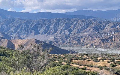
The trail divides naturally into two halves at Muir Trail Ranch (Day 11/12). The northern half, from Yosemite to Muir Trail Ranch, has four resupply options, passes through more varied scenery, and gradually builds the altitude and wilderness experience of the trekker. The southern half, from Muir Trail Ranch to Whitney Portal, is genuine backcountry: higher, wilder, and more demanding, with no further resupply and passes climbing steadily toward the 13,000ft+ range before the final ascent of Whitney.

Who is the John Muir Trail suitable for?
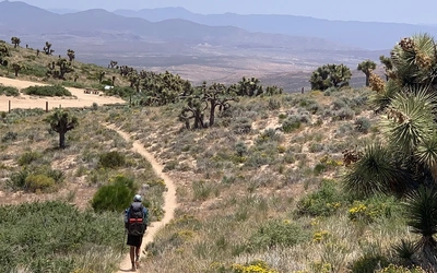
The JMT is recommended for experienced backpackers who have previously walked at least one continuous route of more than 150 miles, preferably in the Scottish Highlands, Alps, or Pyrenees. Some experience at reasonably high altitude is an advantage. The trail itself is not technically difficult — there is no scrambling, no exposure to speak of (the descent from Forester Pass is the one mild exception), and navigation is relatively straightforward on a well-marked trail with the Tom Harrison maps.
The challenge of the JMT lies not in technical difficulty but in self-reliance, endurance, and logistical preparation. Trekkers must be comfortable carrying a heavy pack over sustained distances in high heat, at altitude, through areas several days from outside help. The southern half of the trail, particularly from Muir Trail Ranch to Whitney Portal, requires carrying up to ten days of food — a significant physical demand.
The Half Dome ascent on Day 1 is a different matter: the climb to the summit is over very steep polished granite with fixed cables, and requires some scrambling ability and a head for heights. A separate permit is required and must be arranged in advance.
Solo trekking is possible and common on the JMT, as other hikers are encountered regularly along the main trail during the summer season. Travelling as a group of two or three offers advantages in load sharing, safety, and companionship.
How do I get a permit for the John Muir Trail?
Wilderness permits are legally required for all overnight camping in national parks and wilderness areas along the JMT, and failure to carry one can result in a steep fine. Permits are strictly allocated to limit impact, and during the main summer season competition for them is intense.
Permits must be applied for up to 24 weeks (168 days) in advance of your planned start date from the Wilderness Centre in Yosemite, and the earliest possible application is strongly advised. A permit can be reserved by phone (209) 372-0740, by post, or by fax. There is a small processing fee per person. Written confirmation is sent on acceptance; this must be presented at the Wilderness Centre in Yosemite Valley to collect the actual permit.
Note that a separate permit is required to climb Half Dome ($8 per person; 75 permits per day for backpackers). Apply for this at the same time as your JMT wilderness permit. A permit for the Mount Whitney zone is incorporated into a northbound JMT permit automatically; those walking south to north must apply separately.
The permit system is subject to change and conditions should always be verified before departure at www.nps.gov.
When is the best time to walk the John Muir Trail?
The JMT is a high-level route, mostly above 9000ft and often above 11,000ft, and is only open for a relatively short summer season.
- August is the recommended month. Snow risk and swollen rivers are at their lowest, mosquitoes are less troublesome than earlier in summer, and temperatures at altitude are manageable (high twenties Celsius by day, often at or below freezing at night).
- Early September is also acceptable, with fewer trekkers on the trail and no mosquitoes. The risk of freezing nights increases, and some resorts and stores begin to wind down their summer season by mid-September.
- July is possible but carries meaningfully higher risk: snow may remain on higher passes into the month, rivers swollen by snowmelt can make crossings hazardous, and mosquitoes can be severe in some areas.
- By early October all facilities on the JMT are closed and winter begins at high altitude. The season is definitively over.
The Sierra Nevada has one of the best climates of any high mountain area in the world, with most summer days bringing blue skies and sunshine. However, violent thunderstorms with heavy rain, snow, and hail can occur even in August, particularly in the afternoons. Timing high, exposed passes for the morning is strongly advisable.
How do I get to and from the John Muir Trail?
Getting to Yosemite: The nearest major international airport to the northern trailhead is San Francisco. The recommended route for non-drivers is by bus from San Francisco to Emeryville, then Amtrak train to Merced, then bus to Yosemite Valley — a journey that can be completed in a single day but is best broken overnight in Merced to allow time for buying and packaging food supplies. Allow at least two to three days in Merced and Yosemite before your permit start date.
Returning from Whitney Portal: Whitney Portal is 13 miles from the town of Lone Pine. Eastern Sierra Transit (estransit.com) and YARTS (yarts.com) provide bus services from Lone Pine toward Bishop, Mammoth Lakes, and eventually back to Yosemite, Merced, and San Francisco, or onward to Los Angeles. Most walkers plan an open-jaw flight: inbound to San Francisco, outbound from Los Angeles.
An important note on driving: Hiring a car is not practical for JMT trekkers at the start of the walk, as you cannot park a hire car at Yosemite for three weeks. One-way hire from Lone Pine to Los Angeles is the most useful option at the end of the trek.

What are the resupply points on the John Muir Trail?
Carrying food for the entire 233 miles is not feasible for most trekkers. Food must be packaged and posted in advance to collection points along the route. The four resupply points from north to south are:
- Tuolumne Meadows (Day 3): post office and store inside the Tuolumne Meadows Store. Open weekdays only, 8am to 5.30pm, and the post office operates for only ten minutes per hour. Address packages to: Your Name, General Delivery, Tuolumne Meadows Station, Yosemite National Park, CA 95389.
- Reds Meadow Resort (Day 7): packages collected from Mammoth Post Office by resort staff for a fee of $40 per package. Open 15 June to 10 October. Address to: Your Name, c/o Reds Meadow Resort, PO Box 395, Mammoth Lakes, CA 93546.
- Vermilion Valley Resort (Day 9): the recommended resupply point. $40 handling fee per package (max 25lbs). Packages are collected once a week, so must arrive at least two weeks before your ETA. The resort offers a particularly warm welcome to JMT and PCT trekkers. Address to: Your Name, Vermilion Valley Resort c/o China Peak Landing, 62311 Huntington Lake Road, Lakeshore, CA 93634.
- Muir Trail Ranch (Day 11): the last resupply point on the trail. Food must be sent in a 5-gallon plastic bucket with snap lid, sealed all the way around with duct tape (a 2026 requirement). $115 per bucket (2026 fee). Send at least three weeks before your expected pickup date. Address to: Your Name, Muir Trail Ranch, PO Box 176, Lakeshore, CA 93634.
From Muir Trail Ranch to Whitney Portal there is no further resupply. Food for ten days must be carried from Day 11. Bear-resistant canisters (bear barrels) are mandatory along most of the JMT and must be used to store all food at all times.
What are the highlights of the John Muir Trail?
- Half Dome (Day 1) is the defining image of Yosemite, its sheer granite face visible for miles across the valley. The ascent to the summit via fixed cables is steep and polished, but with some scrambling experience and a head for heights, it is one of the most remarkable summit experiences in the Sierra Nevada.
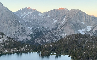
- Thousand Island Lake (Day 5), ringed by the shapely summits of Mount Ritter and Banner Peak, is widely considered the most beautiful lake on the entire trail — the classic JMT postcard shot.
- Devil's Postpile National Monument (Day 6/7) is a geological curiosity: massive columns of basalt remarkably similar to the Giant's Causeway in Northern Ireland, sitting incongruously among alpine forest at the foot of the volcanic Reds Meadow area.
- Vermilion Valley Resort (Day 9 rest day) is reached by ferry across Edison Lake and offers a legendary welcome to JMT and PCT trekkers: hot food, cold drinks, showers, and a chance to recover before the harder southern section begins.
- Muir Pass (Day 13) at 11,955ft is the only col on the JMT with a man-made structure: a stone shelter hut. The lakes either side of the pass — Wanda Lake and Helen Lake — are named after John Muir's daughters.
- Forester Pass (Day 18) at 13,180ft is the highest pass on the trail and the highest point on the PCT. The approach from the south is one of the most dramatic sections of the JMT, with the pass visible high above on a near-vertical wall of rock.
- Mount Whitney (Day 20) at 14,496ft is the highest peak in the contiguous United States and the final summit of the JMT. The view from the summit cairn, after 20 days in the wilderness, is one of the most earned in American hiking.
Essential planning considerations for the John Muir Trail
The JMT requires a level of advance planning unlike almost any walking route in Britain or Europe. Key areas to address include:
Permits: Apply as early as possible, up to 24 weeks in advance. The permit system is competitive in peak season and cannot be left until late.
Flights and travel: Book an open-jaw ticket into San Francisco and out of Los Angeles. Allow several days before the permit start date for food purchasing, packaging, and posting.
Food: The basis of the JMT diet is dehydrated food purchased in San Francisco or Merced. Plan a minimum of 2lbs of food per person per day. Post food packages to resupply points well in advance of your arrival date.
Bear canisters: Mandatory along most of the JMT. Hire is available from the Yosemite Wilderness Centre (book in advance during peak season); purchasing your own is an option for those planning a return visit.
Water: Never drink untreated water. A pump-action water filter is the recommended treatment method for the quantities of water required on a three-week trek.
Altitude: The trail is mostly above 9000ft and reaches 14,496ft on Whitney. Walking north to south allows gradual acclimatisation. Symptoms of acute mountain sickness should be taken seriously; the only cure for HAPE or HACE is immediate descent.
Fitness: Train specifically for backpacking with a heavy pack in the months before the trek. A week-long backpacking trip in mountainous terrain about six weeks before departure is strongly advised.
Plan your trek with the Cicerone guidebook
The Cicerone John Muir Trail guidebook by Alan Castle contains everything needed to plan and complete the full 233-mile route.
- 21 daily stage descriptions with distance, cumulative distance, ascent, descent, and route breakdown tables for each stage
- Trail summary table listing all 21 stages by distance, ascent, and descent
- Topographical height/distance profiles for each stage
- Sketch maps of the route for planning, designed for use alongside the Tom Harrison JMT Map-Pack (13 sheets)
- Comprehensive pre-trip planning guidance covering permits, flights, transport, food provisioning, posting food ahead, bear canisters, equipment, fitness, and altitude
- Wilderness skills sections covering water purification, altitude sickness, bear country, river crossings, and low-impact trekking
- Appendices covering camping areas, ranger stations, escape routes, bear box locations, mountain passes and peaks, useful addresses, bibliography, and a full trail summary table
Available as a printed guidebook (£16.95) or digital eBook (£16.95).
The John Muir Trail
Through the Californian Sierra Nevada
£16.95
Guidebook to walking the John Muir Trail through California's High Sierra from Yosemite (El Capitan and Half Dome) to the summit of Mount Witney. The 216 mile hike is split into 21 daily stages, with full information on preparation, permits, wilderness, bears, water and trekking skills. Part of the Pacific Crest Trail.
More informationAbout Alan Castle, guidebook author
Alan Castle has trekked and cycled in over 30 countries within Europe, Asia, North and South America, Africa, and Australasia, and for 17 years led organised walking holidays in several European countries. A member of the Outdoor Writers and Photographers Guild, he has written 18 guidebooks, several on long-distance mountain routes in France. His longest solo walks include a Grand Traverse of the European Alps between Nice and Vienna (1510 miles), the Pilgrim's Trail from Le Puy to Finisterre (960 miles), and a Coast-to-Coast across the French Pyrenees (540 miles). A Munroist and erstwhile National Secretary and Long Distance Path Information Officer of the Long Distance Walkers Association, Alan now lives at the foot of the Moffat Hills in Scotland, in the heart of the Southern Uplands.