
Article
Free Royal Mail 48 postage on UK orders. European postage is £3.50 per item. Worldwide postage is £5.50 per item. If you're not happy with your purchase for any reason, we'll give you a full refund.
More information...
A resource book covering the finest walks, treks and climbs in the High Pyrenees for 400km between France and Spain, from the Cirque de Lescun, on the edge of the Basque country in the west, to the Carlit massif and the Cerdagne to the east of Andorra. It is the first in our World Mountain Ranges series.
Free Royal Mail 48 postage on UK orders. European postage is £3.50 per item. Worldwide postage is £5.50 per item. If you're not happy with your purchase for any reason, we'll give you a full refund.
More information...
A resource book covering the finest walks, treks and climbs in the High Pyrenees for 400km between France and Spain, from the Cirque de Lescun, on the edge of the Basque country in the west, to the Carlit massif and the Cerdagne to the east of Andorra. The book is divided into five regional chapters: the Western Valleys; Cirques and Canyons; the Central Pyrenees; Enchanted Mountains; and Andorra and the Eastern High Pyrenees. Intended as a resource book for those planning a range of mountain activities in the Pyrenees, the guide describes each area valley by valley, and provides information on access and accommodation, as well as recommended maps and guidebooks. Unlike a conventional walking book, detailed route descriptions are not included; the guide does, however, direct the reader to the finest walks, treks and climbs in the area and provide an outline of specially selected routes. An extensive introduction gives all the practical advice and information needed for planning a trip. It offers a background to the mountains and their exploration, and provides a snapshot of the range with sections that help the reader focus on specific areas of activity, and suggests where best to exercise that activity.
CHAPTER 2: Cirques and Canyons
2:1 Vallée du Gave de Pau
2:2 Vallée d’Estaing
2:3 Vallée d’Arrens
2:4 Vallée de Cauterets
2:5 Vallée du Marcadau
2:6 Vallée de Gaube
2:7 Vallée de Lutour
2:8 Vallée de Bastan
2:9 In and around the Néouvielle reserve
2:10 Vallée de Héas
2:11 Cirque de Gavarnie
2:12 Valle del Ara
2:13 Valle de Ordesa
2:14 Valle de Añisclo
2:15 Valle de Tella
2:16 Valle de Pineta
2:17 Valle de Barrosa
Access, Bases, Maps and Guides
CHAPTER 3: The Central Pyrenees
3:1 Vallée d’Aure
3:2 Vallée du Louron
3:3 Vallée d’Oô
3:4 Vallée de la Pique
3:5 Valle de Gistaín
3:6 Valle del Ésera
3:7 Valle de Eriste
3:8 Valle de Estós
3:9 Vallhiverna
3:10 Upper Ésera
Access, Bases, Maps and Guides
CHAPTER 4: Enchanted Mountains
4:1 Pays de Couserans
4:2 Vallée du Biros
4:3 Vallée de Bethmale
4:4 Upper Vallée du Salat
4:5 Vallée d’Ustou
4:6 Vallée du Garbet
4:7 Vall d’Aran
4:8 Vall Noguera Ribagorçana
4:9 Vall de Boí
4:10 Vall Fosca
4:11 Vall d’Espot
4:12 Vall d’Àneu
4:13 Vall de Cardós
4:14 Vall Ferrera
Access, Bases, Maps and Guides
CHAPTER 5: Andorra and the Eastern High Pyrenees
5:1 Vallée du Vicdessos
5:2 Haute Vallée de l’Ariège
5:3 Andorra
5:4 Vallée d’Orlu
5:5 The Carlit Massif
5:6 The Cerdagne
5:7 Vall de Núria
Access, Bases, Maps and Guides
IGN TOP 25 1:25,000. Sheets: 1547OT, 1647OT, 1748OT, 1748ET, 1847OT, 1848OT, 1947OT, 2047OT, 2048OT, 2047ET, 2148OT, 2148ET, 2249OT, 2249ET, 2250ET
Carte de Randonnées 1:50,000. Sheets: 3, 4, 5, 6, 7
Editorial Alpina: Anso-Echo 1:40,000; Candanchu Canfranc, Pena Telera, Sierra de Tendenera and Penticosa Formigal - each at 1;25,000
Editorial Alpina: Vignemale Bujaruelo, 1:30,000, and Ordesa y Monte Perdido, 1:40,000
Editorial Pirineo: Ordesa and Monte Perdido National Park at 1:40,000
Editorial Alpina: Bachimala, Cotiella, Posets, Maladeta Aneto, El Turbon and La Ribagorca all at 1:25,000
Editorial Alpina: Val d’Aran 1:40,000, La Ribagorca 1:25,000, Pont de Suert 1:40,000, Vall de Boi 1:25,000, Montsent de Pallars 1:25,000, Sant Maurici 1:25,000, Montgarri Mont Valier 1:25,000, Pica de Estats 1:40,000
M.I. Govern: Andorra 1:50,000 and 1:25,000
Editorial Alpina: Cerdanya at 1:50,000 and Serra del Cadi/Pedraforca at 1:25,000
We are always grateful to readers for information about any discrepancies between a guidebook and the facts on the ground. If you would like to send some information to us then please use our contact form. They will be published here following review by the author(s).
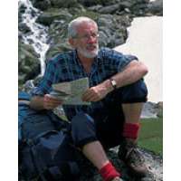
Kev Reynolds was a freelance writer, photojournalist and lecturer. A prolific compiler of guidebooks, his first title for Cicerone Press (Walks & Climbs in the Pyrenees) appeared in 1978; he later produced many more titles for the same publisher. A member of the Outdoor Writers' Guild, the Alpine Club and Austrian Alpine Club, his passion for mountains and the countryside inspired a lifetime's activity, and he regularly travelled throughout Britain to share that enthusiasm through his lectures. Sadly, Kev passed away in 2021. He will be remembered fondly by all who knew him and by many more he inspired through his writing and talks.
View author profile