
The Southern Upland Way
Scotland's Coast to Coast trail


The Southern Upland Way
Scotland's Coast to Coast trail
Guidebook to the Southern Upland Way, a coast to coast walk through Galloway and the Scottish Borders. One of Scotland's Great Trails, the 347km (215 mile) route links Portpatrick on the west coast to Cockburnspath on the east, through diverse landscapes and rich natural and historical interest. It can be completed in around a fortnight.Discover the Southern Upland Way (215 miles/347km), Scotland’s pioneering coast-to-coast trail traversing the entire width of the Southern Uplands from Portpatrick on the Irish Sea to Cockburnspath on the North Sea. This remarkable route weaves through moorland, high hills, wooded river valleys, and striking coastal scenery, offering ever-changing landscapes and a wealth of hidden gems along the way.
Ideal for seasoned trekkers and adventurous newcomers alike, the Southern Upland Way is one of Scotland’s Great Trails and the UK’s most remote waymarked long-distance path. Divided into 14 manageable daily stages, the comprehensive Cicerone guidebook provides route summaries, a stage-by-stage planning itinerary, and practical advice to help you walk the trail in its entirety or in shorter sections, whether over a fortnight, a series of weekends, or as day walks.
- Explore the dramatic Galloway Hills, Carsphairn range, Lowthers, Ettrick Hills, Manor Hills, Minch Moor, and Lammermuirs, passing through quiet hill villages, welcoming B&Bs, and remote bothies. The Southern Upland Way also offers wild camping opportunities and flexible vehicle pick-up and drop-off options to suit every itinerary.
- Uncover the rich history and heritage of southern Scotland: visit Castle Kennedy Gardens, the Covenanters’ memorials, the historic lead mining village of Wanlockhead, fortified pele towers and bastles, Traquair House, the iconic Melrose Abbey, Thirlestane Castle, and ancient prehistoric cairns.
- Elegant towns like Moffat and Melrose provide charming stopovers on the Southern Upland Way, while each stage features concise information on places of interest, local history, and points of cultural significance.
- The Southern Upland Way offers a true sense of discovery, leading walkers through one of Britain’s least-visited and most unspoilt regions. Most days include high ground above 450m, rewarding you with panoramic views and a sense of exhilarating solitude.
- The trail is best enjoyed between April and October, when the days are longer, and the weather is generally more favourable. Guidance is provided on accommodation and public transport links, especially at key points like Beattock/Moffat, and on strategies for both backpacking and supported walking, making the Southern Upland Way accessible to walkers of all levels.
- Navigate the Southern Upland Way confidently with Ordnance Survey (OS) Landranger (1:50,000) maps, downloadable GPX files, and detailed stage-by-stage breakdowns. Each section begins with a summary table of distances and highlights, ensuring you’re well prepared for every day’s adventure.
Plan your Southern Upland Way adventure with confidence and immerse yourself in the wild landscapes, fascinating history, and hidden treasures of southern Scotland, supported every step of the way by your comprehensive Cicerone guidebook.
Southern Upland Way – Quick Facts
Trail name: Walking the Southern Upland Way
Location: Southern Uplands, Scotland, UK — coast-to-coast long-distance trail
Total distance: ~347 km / ~215 miles
Typical duration: ~12–16 days end-to-end (can be done in ~2 weeks)
Start: Portpatrick (Irish Sea coast)
Finish: Cockburnspath (North Sea coast)
Route type: Linear long-distance waymarked walking route in stages (traditionally 14)
Difficulty: Challenging; remote hill country with varied terrain requiring fitness and navigation skills
Terrain: Moorland, high hills, wooded valleys, upland ridges and coastal sections
Navigation: Ordnance Survey (OS) maps, detailed stage descriptions, and GPX files available
Best season: April to September for longer days and more favourable conditions
Author Highlight
“Long-distance walking is all about exploring new territory and at a pace where it can be fully savoured. The Southern Uplands of Scotland are probably the least visited area of Britain, and it is likely that most walkers who venture out from Portpatrick on the west coast will be discovering an area that for them was hitherto unknown: they will be pleasantly surprised. The Southern Upland Way has it all! If you choose this trail for your annual walking holiday then you will certainly not be disappointed."
- Alan Castle, author of The Southern Upland Way
Printed book
A guidebook with detailed route descriptions, stage breakdowns, accommodation listings, profiles and maps - everything you need on the trail.
ISBN
9781852849931
Availability
Published
Reprinted
19 Aug 2022
Published
12 Jul 2018
Edition
Second
Pages
192
Size
17.20 x 11.60 x .90cm
Weight
220g
eBook
The complete digital edition of the guidebook, with full route descriptions, accommodation listings, profiles and maps, ready to use on any device. To access your eBook, you will need an eReader app. For more details, visit the eBook FAQs.
Map key
Overview map
Route summary table
Introduction
The Southern Upland Way
West to east or east to west?
When to go
Ways of tackling the SUW
Luggage transfer and drop-off/pick-up services
Accommodation
Getting to and from the SUW
Planning and preparation
Equipment
Maps
Waymarking and navigation
Access in Scotland
Ticks
Completion certificates and SUW badges
A high-level alternative coast-to-coast route
Using this guide
The route
Stage 1 Portpatrick to Castle Kennedy
Stage 2 Castle Kennedy to New Luce
Stage 3 New Luce to Bargrennan
Stage 4 Bargrennan to the Glenkens
Stage 5 Across the Glenkens
Stage 6 The Glenkens to Sanquhar
Stage 7 Sanquhar to Dalveen Pass
Stage 8 Dalveen Pass to Beattock (Moffat)
Rest day – Moffat and environs
Stage 9 Beattock (Moffat) to Ettrick
Stage 10 Ettrick to Traquair (Innerleithen)
Stage 11 Traquair (Innerleithen) to Melrose
Stage 12 Melrose to Lauder
Stage 13 Lauder across the Lammermuir Hills to Longformacus
Stage 14 Longformacus to Cockburnspath
Appendix A Itinerary planner
Appendix B Bothies along the SUW
Appendix C Bibliography
Appendix D Useful contacts
Seasons
April to September, with May and June the best months of all
Centres
Portpatrick, Castle Kennedy, New Luce, Bargrennan, St John's Town of Dalry, Sanquhar, Wanlockhead, Beattock/Moffat, Traquair, Galashiels, Melrose, Lauder, Longformacus, Abbey St Bathans, Cockburnspath
Difficulty
The route is waymarked throughout, and paths are mostly good, but much of the hill country is remote and little frequented and in places the path is faint. Self-reliance and some navigation skills are required. For backpackers, the route has 5 bothies and unlimited wild camping possibilities. For walkers, maximum daily stages of up to 19 miles (30km) are assured by using vehicle pick-up services, as detailed in the book.
Must See
Portpatrick coast path; Loch Trool; Lowther Hills; Minch Moor drove road; Lammermuir Hills; new official high-level route through the Ettrick Hills; Castle Kennedy Gardens; Wanlockhead Lead Mines; Melrose Abbey; Thirlstane Castle
June 2025
Summer 2025 updates
Updates with thanks to Mr Tim Lewis 2025
Section 9 preamble: add at end
NOTE: both the higher alternative before Ettrick Head, and the combined route above Selcoth Burn, cross steep and rather exposed slopes, intimidating to some and risky in icy conditions.
P127 first line: wooden steps now gone. Just keep ahead uphill on the rough path.
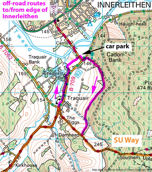
P132: additional distance to Innerleithen, amend to 2.5km (1.5 miles)
P145 top: This is unclear. The alternatives are
a) From the crossroads in Traquair, take thelane heading uphill, south-eastwards. Keep ahead up a dirt track, so beginning the long ascent onto Minch Moor.
b) If starting from Innerleithen, there’s a more attractive return route. Return over the Tweed to the 7Stanes car aprk. From its corner, the well built path runs to left of the road, across a side road, then steeply uphill. It runs along the foot of plantations, with wide views across the Tweed valley. After 1.2km it crosses an uphill track, to a second one, which is the SUW 0.75km above Traquair.
P155 top: the riverside path diverts briefly away from an eroded section of riverbank, then returns.
P159 2nd main para: As the slope eases, 'continue straight ahead (north-east) at a track fork' is more of a 'at a track fork, bear left (north-east)'.
P160 2/3 way down: 'The SUW dodges into woods on the right' – At summer 2025 there are fallen trees to work your way around here.
P160 last sentence: Lauder lies in the deep valley ahead; the Way drops a little towards Lauder Burn, but after a ladder stile, it turns up right to reach, rather surprisingly, the 13th tee of Lauder Golf Course. (But there’s an alternative path dropping to Lauder Burn, which is also usable.)
P165 foot: ‘the right-hand edge of the conifer plantation seen ahead”. This has now (summer 2025) been felled, and progress along its right-hand edge is currently awkward in the aftermath…
P168 line 4: 'Wide, smooth track' is now tarmac surfaced.
P173: last word ‘red’. Now repainted black.
P174 first para: having reached the start of the concrete track to Whiteburn, follow it as far as the farm before turning off left as indicated.
P185 could have pronunciation guide:
Stranraer StranRARR
Knowe Now
St John’s Town of Dalry Dalry
Stroanpatrick Strone-patrick
Sanquhar Sanker
Daer Reservoir Darr Reservoir
Over Phawhope Over Fawup
Scabcleuch (and other cleuchs) ClooCH (ch as in ‘loch’
Dryhope Dryup
Traquair Tra-KWARE
Innerleithen Inner-leethun
Lauder Lorder
Longformacus Long-for-MACK-us
Abbey St Bathans Abbey Saint BA-thuns )(not Baythuns or Barthuns)
Cockburnspath Co’path
July 2022
Appendix D
General: The accomodation on the SU Way is like the people using it – it comes and goes. The SU Way website at its new address dgtrails.org/southern-upland-way/ is the start point for current information. Do please report any fresh information, updates or corrections via the feedback form there.
Accommodation providers providing vehicle backup: Brookford B&B at Dalry no longer offers pickups across the Glenkens (Pick-up points 1 and 2). A current accommodation provider in the Glenkens may offer car pick-up on an informal basis: it's always worth asking.
June 2022
2022 reprint route updates
993 Reprint 2022 Rpt (1.66 MB)
March 2021
Stage 7 shelter
At the highest point of the SU Way, the Lunch Box on Lowther Hill (p103) is now a comfortable small shelter, timber lined, with a bench inside.
December 2020
Stage 9 Moffat
Winter 2020/21, the Barnhill Bridge over River Annan NT 092 029 is closed for repairs. Signs divert walkers into Moffat by Annandale Way and out again by Oakrigg, ie the alternative routes marked on pages 112 and 124. Works should be completed by spring 2021.
February 2020
Stage 10 end: continuation to Innerleithen
Most walkers will need to continue from Traquair to Innerleithen to find accommodation. There is now a pleasant footpath from the war memorial at Traquair running to left of the road through fields and woods to the Tweed bridge near the edge of Innerleithen, replacing what was a nasty road walk (and an even better one for the return to the SU Way in the morning).
see MAP below Stage 11 update.
February 2020
Stage 4 start: alternatives (p67)
An excellent roadside footpath has (in 2019) been made from the House o' Hill at Bargrennan to Glentrool village. This would allow you to take advantage of any facilities at Glentrool, although there are currently none. Continuation would be by a roadside footpath east to Stroan Bridge, and downstream to left of Water of Minnoch to rejoin the SU Way by a footbridge over Water of Trool. However the riverside path of the SU Way is a better route.
February 2020
Stage 11: opening
If you stay overnight in Innerleithen, there's a very attractive link path (built 2020) to take you back to the SUW. Return over the Tweed to the car park for the 7Stanes mountain bike area. From its corner, the well built path runs to left of the road, across a side road, then steeply uphill. It runs along the foot of plantations, with wide views across the Tweed valley. After 1.2km it crosses an uphill track, to a second one, which is the SUW 750 metres above Traquair.
see Map below:
January 2019
Route Updates
Appendix D, accommodation providers offering luggage transfer:
New for 2019, a string of B&Bs / hotels offer piecemeal baggage transfer covering the entire route (provided you stay at their places) – see the official website at www.southernuplandway.gov.uk.
Dec 2018
Some updates to the accommodation listing column in Appendix A: but please refer to www.southernuplandway.gov.uk for the most current information.
184km Brattleburn bothy (near): Bunkhouse (Rivox)
220km Scabcleuch: B&B (Cossarshill) – see previous update!
247km Traquair: no accomm (but Innerleithen does have)
251km Minch Moor: B&B at Yarrowford
322.5km B6355 Lodge Wood: B&B (Greenhope)
Aug 2018
Page 122 The unofficial high-level line above Ettrick glen, Stage 9 'Alternatives', is covered in full on the Harvey Maps route map of the Southern Upland Way.
June 2018
Accommodation update: the 2018 revisions to the official website at www.southernuplandway.gov.uk have uncovered lonely B&Bs at New Luce (end Stage 2), at the foot of Ettrick glen (end Stage 10) and Longformacus (end Stage 11). The second of these in partricular will make it possible for energetic walkers to complete the Way without needing vehicle pick-ups and drop-offs. Please check the official website for details.
Free Royal Mail 48 postage on UK orders. European postage is £3.50 per item. Worldwide postage is £5.50 per item. If you're not happy with your purchase for any reason, we'll give you a full refund.
Learn moreDiscover the Cicerone App
The Cicerone App brings decades of expertise straight to your phone, making it easier than ever to plan and enjoy your adventures wherever you are. For use with In-App guides — not compatible with eBooks.


Popular related guides


