6 of the best valley walks to get to know Snowdonia

North Wales is a landscape that has been hundreds of millions of years in the making. Through volcanoes, moving continents, Ice Ages and the industrialisation and use of the landscape by man, its shape has changed greatly over time. Into this landscape thousands of different species of animals, plants and fungi have made their home. Is it best seen and ‘done’ by walking a well-used path to a high summit? Absolutely not. Alex Kendall, author of Snowdonia: Low-level and easy walks – North, says to really experience the mountains, forget bagging summits and head to the valleys.
Experiencing any journey would be two-dimensional with only one sense and, likewise, you can barely experience a mountainous landscape by just aiming for the summit. After all, it is only one part of the whole hill, and the route up is just one small trail on a landscape filled with secrets.
To really understand the land, to get under its skin, you should take to the valleys and lowlands. Follow streams, search out those paths on the map that don’t seem to lead anywhere other than to other paths, check out what that next little bay along the coast really looks like, touch rocks and trees (not being weird but, really, I have often found few things feel the way your head tells you they will; rocks are warmer than expected and trees rougher). And listen out for things: birds, rain through the trees, sheep being herded. The walking is, in a way, just a means to an end. Anyone who slogs up and down a mountain to ‘bag’ it or just for that summit photo misses out.
These valleys are for everyone, whether you don’t feel you want to climb mountains, or whether you always climb mountains and want to see what all these lowland trails are about. To get you interested here are some of the places visited in Snowdonia: Low-level and easy walks – North, and what you’ll see.
Snowdonia: 30 Low-level and Easy Walks - North
Snowdon, the Ogwen and Conwy Valleys and the coast
£12.95
Guidebook describing 30 walks in Snowdonia, Wales. Routes are mostly low level and on clear paths and showcase the region's beautiful scenery and rich history and culture. Part of a 2-volume set, this northern volume includes the Snowdon area, the Ogwen and Conwy valleys, Betws-y-Coed, Beddgelert, Ffestiniog and the coast.
More informationThe Vale of Ffestiniog
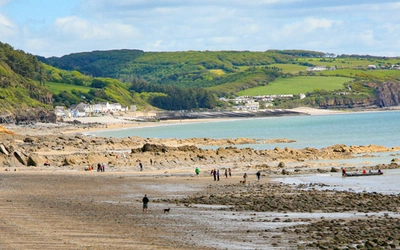
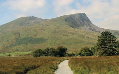
The sea rolls onto the beach at Black Rock Sands, the silhouette of Criccieth Castle on the headland a hard set of lines. The sand dunes run along the back of the beach, their soft rolling shapes covered in marram grass, and offer places you can walk to quickly dull the sound of other beach walkers and their dogs. Further inland, rising from the flatlands of the human-engineered silted former Glaslyn estuary, are the cliffs of Tremadog, formerly coast and now an inland climbing hotspot.
The view from these cliffs, accessed by what feel like secret paths up around the towering rock, reaches all the way from the estuary to Snowdon, past the Moelwynion. These middle hills point towards the sea with their own prow, the iconic triangular peak of Cnicht, pronounced as it is spelled, with a hard C, and meaning ‘the knight’. Seen from the higher mountains in the north it is an ignoble lump, rolling off the edge of other rolls in the hills. But from here, and from Moel y Gest outside Porthmadog, it is the most eye-catching peak, prouder even than Snowdon, cutting its line in the sky.
Head up the Vale of Ffestiniog, past the nesting ospreys near Plas Tan y Bwlch. The hills close in on both sides; in the north the Moelwynion, in the south the Rhinogydd, and on the horizon the vast raised moorland of the Migneint, where the ice sheet was born. Stop in Coed Felinrhyd when the wide-open spaces become too much; the woodland floor is covered in dozens of different mosses, all their own shade of green and red. And not just the floor – up the trees, over rocks, across the path. Mosses, liverworts and ferns showing that in Wales, winter is green.
It was in this woodland that Pryderi, lord of Dyfed, met his mythical death in the epic Welsh stories of the Mabinogion. He was killed in a battle to avenge him being tricked out of his prize pigs, which sounds ignominious, but to be fair it’s a fate that has probably befallen very few heroes in mythology.
The Lledr Valley
Up over the Crimea Pass, past the colossal slate tips at Blaenau Ffestiniog, the Lledr Valley is peaceful and secluded, the river running slowly and the hill-lines smoother. Even in the sun Dolwyddelan castle retains menace, and down past the village the river loses its sedate feel, plunging into gorges when the woods close in and allow it to play a bit. These woods are part of Gwydyr forest, stretching from here past Betws-y-Coed and covering all the hills in conifers. Here is the human in the hills; first mineral mining and then forestry, and on these slopes are the remains of the industry that went on for thousands of years; hidden by the trees are houses, mine ruins and reservoirs. They are being reclaimed by nature as phosphorescent lichens and ochre tree needles colour the ground.
On your way through stop at the church in Dolwyddelan, a village whose name translates as the ‘field of the little Irishman’. This nameless Irishman was a missionary, much like Curig of Capel Curig, and hanging from the roof of the church you will see a cracked and time-beaten bell, supposedly brought over from Ireland in the 7th century.
Nant Gwynant
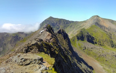
Stopping to pay homage to the Tylwyth Teg, or Welsh fairies, in the gorge of the Fairy Glen, head west past the almost-forgotten Roman fort near Capel Curig and pause at the viewpoint down the Nantgwynant towards Beddgelert. Over on the right is the Pen-y-Gwryd Hotel, where those who completed the first successful Everest expedition stayed during training. In front are the slopes of Snowdon, where King Arthur fought and died, and under whose slopes Merlin first proved he was different to other men, releasing the dragons and telling the prophecy of the Britons on Dinas Emrys.
This valley is shaped by the Afon Glaslyn, the river that runs through its heart. Starting high on Snowdon at Llyn Glaslyn, surrounded by the ducts and passages of the old copper mines that still run deep into the mountain, it moves sedately through Llyn Llydaw before plunging down into the main valley and doubling back. Here it sets the area’s character, forming both Llyn Gwynant and Llyn Dinas before reaching Beddgelert and the Pass of Aberglaslyn. Only glancing at its beauty are walkers heading up Snowdon’s Watkin Path, probably the only walking trail opened by a prime minister, leading them up into Cwm Llan on the south side of Snowdon, and Wales’ highest nature reserve.
East from Snowdon
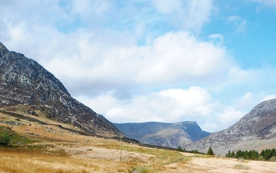
The roads around the northern mountains run high, taking you over the passes. Walk a bit away from the traffic and you’ll hear the birds of the hills. That seemingly never-ending song is the skylark, almost invisible up above, defending its territory. The similar small birds flying up then parachuting down are the pipits, feigning injury to lead you away from their nests. It’s a hard life being a ground-nesting bird, always wary of egg-stealers and rising water. Down past the last site of Welsh medieval independence at Dolbadarn castle you could do worse than to swim in the glacially carved lake of Llyn Padarn. Above are slate tips almost as big as at Blaenau Ffestiniog, industry turned to tourism and decades of pioneering climbing, now bidding to be UNESCO listed.
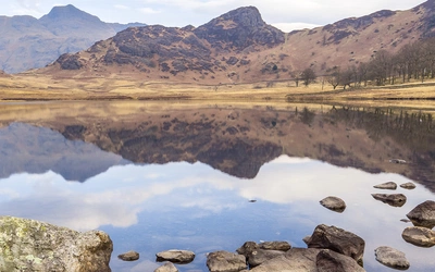
The mirror of this valley, just over the Glyderau, is the long pass through the great peaks known as the Ogwen Valley and then the Nant Francon. Most favoured of all the lakes in Wales is Llyn Idwal, up in a raised valley not quite seen from the road, bound on three sides by tremendous crags, now the playground of climbers and scramblers but once, with the great cleft of the Devil’s Kitchen in the headwall, the place where the druids would hurl down curses on the invading Romans as they headed north to Anglesey. And here is sadness, too, as it is the site where Prince Idwal was drowned by his jealous cousin and uncle. We can also see the passage of time – idyllic upland tarns such as this are slowly silting up, destined one day to be marsh, then dry land.
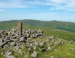
The Carneddau
Any walk north on the slopes of the Carneddau forces you to acknowledge the sea and the Isle of Anglesey, the last stronghold of the druids. These hills, now home to herds of Welsh mountain ponies, seem high and lonely but contain a staggering concentration of ancient sites. There are settlements, trackways and tombs, and of course magnificent stone circles. Stand in them to see how dramatic their position is; how the rolling hill and the rolling sea meet in these places.
On the southern side of these mountains, on the highest walk I’d still call low level, there’s a track that takes the walker swiftly to the Dulyn reservoir, well known because of the nearby bothy. The lake, now raised a bit by the weir, has always been dark and deep, so much so that it was assumed to be bottomless (as are many eerie lakes in the hills). It has been said that birds would not fly over it and on the edge was a rock called The Red Altar, where if you sprinkled water you could summon the rain. That this was needed as a superstition should reassure anyone who worries that it’s never hot and sunny in Snowdonia.
The Conwy Valley
Conwy stands at the northern tip of the national park, its castle dominating the river crossing. Built by Edward I during his conquest of Wales, the town walls contain parts of Llywelyn the Great’s court house, and a statue of this Prince of Wales stands in the main square. Down by the river, on the tidal mudflats where you can spot little egrets and wading birds, it feels like the end of a journey. All the more reason to turn back and head out into Snowdonia again to find what you’ve missed. Heading down the Conwy River would be a start, to a land where the fearsome Afanc used to flood the valley. Or perhaps into the forests to find bilberries and smell the vanilla perfume of the gorse.
In all these places, these walks that can be slightly dismissively called ‘low-level’, but there is more than just the chance to go on a walk and claim a summit. There is the chance to begin to understand where it is you are walking. And for that, you’ll need all your senses.
Snowdonia: 30 Low-level and Easy Walks - North
Snowdon, the Ogwen and Conwy Valleys and the coast
£12.95
Guidebook describing 30 walks in Snowdonia, Wales. Routes are mostly low level and on clear paths and showcase the region's beautiful scenery and rich history and culture. Part of a 2-volume set, this northern volume includes the Snowdon area, the Ogwen and Conwy valleys, Betws-y-Coed, Beddgelert, Ffestiniog and the coast.
More information