 Pre-order
Walking the Shropshire Way
A two-week circular trail including the Wrekin, Stiperstones and Wenlock Edge


Walking the Shropshire Way
A two-week circular trail including the Wrekin, Stiperstones and Wenlock Edge
Guidebook describing a 2 week trail around Shropshire. The 182 mile (290km) route is made up of two loops centred on Shrewsbury and visits Stiperstones, Wenlock Edge, Ironbridge and the Wrekin. Also describes the challenging 20 mile (32km) Stretton Skyline Walk.Discover the Shropshire Way (182 miles/293km), an inspiring two-week circular trail that reveals the very best of England’s quietly captivating county. This official guide has been prepared in consultation with the Shropshire Way Association and Shropshire Council, ensuring you have the most authoritative and up-to-date information for your journey.
Beginning and ending in historic Shrewsbury, the route meanders through the unspoilt heart of Shropshire. Ideal for both seasoned walkers and new adventurers, the Shropshire Way offers remarkable flexibility. Complete the full loop in a single adventure, split it into northern and southern circuits using the Shrewsbury Link, or walk stage by stage with the help of excellent rail and bus connections at Shrewsbury, Ludlow, Wellington, and Whitchurch.
Traverse legendary landscapes, the Wrekin, Stiperstones, Wenlock Edge, and the dramatic Long Mynd, while visiting vibrant market towns such as Clun, Ludlow, Ironbridge, Wem, and Whitchurch. This comprehensive Cicerone guidebook divides the Shropshire Way into 15 manageable daily stages, each unveiling a tapestry of serene rural beauty: from rocky outcrops and escarpments in the south to wide, pastoral plains and sleepy hamlets in the north.
- Includes a stage-by-stage itinerary for the Shropshire Way, suggested accommodation, and practical advice for walking at any time of year.
- Explore the rich diversity of Shropshire: ascend the Long Mynd, Caer Caradoc, and Hope Bowdler Hills on the scenic Stretton Skyline Walk, or wander through vibrant towns and tranquil countryside dotted with historic landmarks.
- Discover the county’s living history at every turn on the Shropshire Way, from imposing castles and ancient abbeys to the industrial heritage of Ironbridge and the hilltop fortresses that once guarded these wild borderlands.
- Each stage features essential information on distance, height gain, terrain, refreshment stops, and local transport, helping you plan your perfect walking holiday in Shropshire.
- Start the Shropshire Way wherever you choose, though transport links make Shrewsbury the most convenient, and tailor your itinerary to match your pace. Whether you prefer a leisurely two-week exploration or an energetic 12-day challenge, the route adapts to every kind of walker.
- Navigate the Shropshire Way with confidence using OS Landranger (1:50,000) mapping and clear stage breakdowns, supported by downloadable GPX files.
Plan your Shropshire Way adventure with confidence and immerse yourself in one of England’s most serene and scenic counties, supported every step of the way by the definitive Cicerone guidebook.
Shropshire Way – Quick Facts
Trail name: Walking the Shropshire Way
Location: Shropshire, West Midlands & Wales borders, England, UK
Total distance: ~290 km / ~182 miles (full circular route)
Typical duration: ~2 weeks end-to-end (or two separate loops in ~1 week each)
Start / Finish: Shrewsbury (circular route)
Route type: Long-distance circular walking route in 15 stages
Difficulty: Moderate; daily distances ~11–15 miles (17–24 km) require reasonable fitness
Terrain: Rolling countryside, ridges (Stiperstones, Wenlock Edge), hills and rural paths
Navigation: 1:50,000 OS maps included; GPX files available
Extras: Includes the challenging Stretton Skyline Walk option (~32 km / ~20 miles)
Highlights: Stiperstones ridge, Wenlock Edge, Ironbridge Gorge, historic towns (Ludlow, Bishop’s Castle)
Author Highlight
“Shropshire has been blessed with some of England’s most serene rural beauty, from its colourful red earth, which adds a richness to the pastures and cliffs, to sleek escarpments, rocky outcrops and verdant pastured ridges in the south and its wide plains and charming sleepy villages in the north. In between, the River Severn slithers and meanders like a serpent on its long journey from mountain to sea… And Shropshire as a whole is quiet and peaceful, with only two big towns: Shrewsbury and Telford. Others, such as Whitchurch, Ludlow, Bishop’s Castle and Bridgnorth, are small but very pleasant market towns, many with a violent and colourful past, for Shropshire borders Wales and has often fallen to the Celtic princes from the west. Ruined castles in all corners of the county and Offa’s Dyke on the western border are a testament to this past."
- John Gillham, author of Walking the Shropshire Way
Printed book
A guidebook with detailed route descriptions, stage breakdowns, accommodation listings, profiles and maps - everything you need on the trail.
ISBN
9781786310088
Availability
Published
Reprinted
1 Jul 2022
Published
25 Oct 2019
Edition
First
Pages
192
Size
17.20 x 11.60 x 1.15cm
Weight
220g
eBook
The complete digital edition of the guidebook, with full route descriptions, accommodation listings, profiles and maps, ready to use on any device. To access your eBook, you will need an eReader app. For more details, visit the eBook FAQs.
Overview map
Overview profile
Map key
Foreword
Route summary table
Introduction
The Shropshire Way
Shropshire’s history
Shropshire’s geology (by Ronald Turnbull)
Wildlife and plants
When to go
Getting there
Getting around
Accommodation and planning
Safety
What to take
Using GPS
Waymarking
Using this guide
The Shropshire Way
Stage 1 Shrewsbury to Bridges
Stage 2 Bridges to Bishop’s Castle
Stage 3 Bishop’s Castle to Clun
Stage 4 Clun to Craven Arms
Stage 5 Craven Arms to Ludlow
Stage 6 Ludlow to Wheathill
Stage 7 Wheathill to Wilderhope Manor
Stage 8 Wilderhope to Ironbridge
Stage 9 Ironbridge to Wellington
Stage 10 Wellington to Haughmond
Stage 10A Haughmond to Shrewsbury link
Stage 11 Haughmond to Wem
Stage 12 Wem to Ellesmere and Whitchurch
Stage 13 Ellesmere to Llanymynech
Stage 14 Llanymynech to Nesscliffe
Stage 15 Nesscliffe to Shrewsbury
Stretton Skyline Walk
Appendix A Facilities table
Appendix B Accommodation
Appendix C Travel information
Appendix D Useful contacts
Seasons
The walk can be done in all seasons, but spring, summer and autumn are best as woodland paths can be slippery in winter. Regardless of the season, waterproofs are essential
Centres
Shrewsbury, Bishop's Castle, Clun, Craven Arms, Ludlow, Much Wenlock, Ironbridge, Wellington, Wem, Whitchurch, Ellesmere, Llanymynech, Nesscliffe
Difficulty
The well-marked Way is 182-200 miles, depending on the route chosen, and requires moderate fitness and a good pair of walking boots to cover approximately 12 miles each day. The hills are generally gentle and rolling, although Stiperstones has a rough quartzite ridge
Must See
Shrewsbury's ancient architecture; the Stiperstones; Offa's Dyke; Clun Castle; historic Ludlow; Brown Clee Hill (Shropshire's highest); Wenlock Edge; Ironbridge, birthplace of the Industrial Revolution; the Shropshire Union Canal; Haughmond Abbey; Grinshill sandstone quarry
March 2025
Stage 8
Pages 97 and 98 (map below)
In 2024 landslides below the Benthal Edge near Ironbridge made the old Shropshire Way route tricky and the Shropshire Way Association have devised a new route as follows:
Take the right fork path then turn right through a walkers’ gate next to a farm gate. This leads to a farm track, which should be followed along the field-edge.
Soon after passing the brick-built farmhouse and outbuildings of the Benthall Estate the track comes to Benthall Hall’s visitor car park. Turn left here and go through the smaller of two gates onto another track passing St Bartholomew’s Church, beyond which there are glimpses of the main hall.
Through another gate go straight on along a field-edge track which passes beneath rows of pylons before coming across more gates close to a junction of tracks. Take the track on the right. This comes to a road-end. Follow this down to the outskirts of Broseley, ignoring a right fork lane.
At the bottom of the lane turn left downhill towards Ironbridge. As you approach Ironbridge follow the pavement on the right side of the road as it veers slightly away and down towards some houses. Some steps at its end take you down to the old Iron Bridge in the centre of town.
Benthall Edge alternative (2.195 MB)
February 2023
Diversion at Mountfields (p161)
Shrewsbury council says the Shropshire Way path in Mountfields is unstable and has prohibited its use between its junction with Mount Street to the steps at the bottom of Hunter Street. The Order expires in June 2023.
To avoid this turn right up Mount Street then left along Alma Street. Turn right down to the end of Hunter Street where you turn right along the continuing Shropshire Way (signed path).
December 2021
2022 Reprint route updates
1008 Shropshire Way 2022 Rpt updates (3.771 MB)
July 2021
Temporary closures
IMPORTANT INFORMATION ABOUT A TEMPORARY CLOSURE ORDER FROM THE SHROPSHIRE WAY ASSOCIATION
The SW main route is closed from Monday 24th May for up to 6 months at the moment from the north end of Drinkwater Street (SJ48681308) in Frankwell to Doctor’s Field (SJ48421315) and vice versa, while the riverside footpath is closed for embankment stabilisation works.
There is a suggested description of the alternative route. It adds some 250 metres to the route.
From the top of the steps at the north end of Drinkwater Street (SJ48681308), follow this street south for 80 metres to Hermitage Walk. Turn right and follow this path for 170 metres until it becomes the pavement of The Mount. Continue along this for a further 160 metres until a narrow footpath between brick walls goes right. Descend this footpath for 120 metres until it joins the riverside footpath at SJ48421315.
At SJ48421315, at a noticeboard, a footpath leaves the riverside route to the right, crosses Doctor’s Field and climbs up to meet The Mount after 120 metres. Turn left along the pavement for 160 metres until a tarmac path (Hermitage Walk) bears left. Follow this path for a further 170 metres until it meets Drinkwater Street. Turn left and follow this street for 80 metres until you reach the top of some steps. Turn right here (SJ48681308) onto the narrow footpath which is the SWMR.
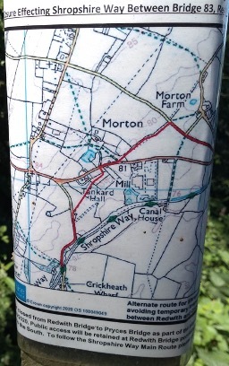
TEMPORARY CLOSURE OF MONTGOMERY CANAL TOWPATH BETWEEN REDWITH BRIDGE AND CRICKHEATH WHARF
The canal towpath used by SW main route is closed until 31 October 2021 between Pryce’s Bridge and Crickheath Bridge and for canal restoration works. This will necessitate a diversion NW along the road from Redwith Bridge SJ 301 241 then a cross-field path SW to the B4396, followed by another field path in the grounds of Tankard Hall. A lane then leads back to Crickheath Bridge where the towpath continues to Llanymynech. (see diagram)
April 2021
Route west of Brown Clee Hill
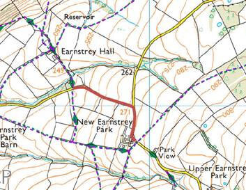
The Shropshire Way Association has made a change to the Shropshire Way due to constant poor ground conditions over some land.
The route change is between SO 57527 88108 and SO 57923 87771 around New Earnstrey Park in Abdon and Tugford Parish, Shropshire, so the new route will follow the County Road rather than cut across the fields. New route is shown in red on the map.
On P87 of the guidebook it should now read:
Turn left along the lane, passing New Earnstrey Park Farm before turning left at the next junction. Follow the stony, grass-islanded track to Earnstrey Hall.
November 2020
Correction
Altitude chart pages 6 and 7
The first summit should be labelled Wilderley Hill. Stiperstones should point to the next summit at 530m and 18 miles.
August 2020
Teashop closed
Page 63 The guide says that the route turns after passing the Tea on the Way teashop. Unfortunately, this has now permanently closed therefore there will be nothing for a walker to use as a marker to make a left turn.
Free Royal Mail 48 postage on UK orders. European postage is £3.50 per item. Worldwide postage is £5.50 per item. If you're not happy with your purchase for any reason, we'll give you a full refund.
Learn moreDiscover the Cicerone App
The Cicerone App brings decades of expertise straight to your phone, making it easier than ever to plan and enjoy your adventures wherever you are. For use with In-App guides — not compatible with eBooks.


Popular related guides


