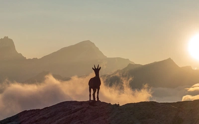
Refuge de la Breche and the Cirque de Gavarnie

40 years of Walks and Climbs in the Pyrenees

Walks & Climbs in the Pyrenees is 40 years old. First published in 1978, it’s never been out of print and, following numerous updates and reincarnations, the latest edition is imminent. It’s the granddaddy of our guides, so we asked its author, Kev Reynolds, to look over his shoulder and tell us about the changes that have occurred to the mountains and trails, as well as the book, since the 1970s.

Cicerone’s early guides were colour free and produced to the standards of the time, so when Walks and Climbs first appeared it consisted of 100 route descriptions, 12 roughly drawn sketch maps, 10 black and white photos and five pen and ink drawings by Brian Evans.

Expectations were simple, and activity in the Pyrenees a case of make-it-up-as-you-go-along. There was more snow cover on the mountains then. And more glaciers. But fewer manned huts, fewer roads and footpaths and no waymarks. I’d already been climbing there for 10 years and loved the solitude. In the early days we’d take an overnight train from Paris to Luchon where we’d buy several baguettes, strap them to the top of rucksacks that already weighed 25kg and hike 11km of broken road to the Hospice de France. Then up and over the Port de Venasque into Spain, to settle our tent below the Maladeta in readiness for a fortnight’s climbing among the highest peaks, certain that we’d see no-one except, perhaps, a solitary shepherd, before arriving back in Luchon for the train home.

Spanish maps were a joke. Apart from countless inaccuracies, they allowed no overlap into France and ended on the border, leaving blank spaces that ought to have been filled with the words: ‘There be dragons.’

When I first walked and climbed there the only English language guide was by Charles Packe, and that had been published in 1862. So I’d been told. I’d never even looked at a guidebook, let alone used one, so when Cicerone founder Walt Unsworth asked me to write one for the Pyrenees, I first had to find out what kind of information was needed.

Until then my idea of climbing was simply to choose a mountain, decide on a line and if it took us to the summit – fine.

If not, because we were either incompetent, got lost or retreated through fear, well, as long as we’d had a good day out and neither of us had drawn blood, we counted that a success. We had nothing to prove. But writing a guidebook changed all that. Getting lost or failing on a climb was serious. I had to make sure my readers didn’t make the same mistakes.

I was running a youth hostel at the time and using precious leave to gather routes among mountains that were at least a couple of days’ journey from home. Other climbing friends helped; friends with cars who’d burn rubber getting from A to B to explore areas that had no access by train or bus. That way I summited peaks I’d barely heard of before and trekked through flower-filled valleys straight out of dreams. Every fresh horizon was full of promise and, as my knowledge of the range increased, my love affair with the Pyrenees deepened.

Just the beginning

Through ignorance or innocence, I imagined one edition of the book would suffice. I had no thought of updating or producing further editions, but Walt did, and with his encouragement I tackled the newly established Pyrenean Haute Route between the Cirque de Lescun and Andorra, and explored five new areas to include along with 40-odd extra routes in a second edition that came out in 1983.

Gustav Dobrzynski, a geographer/cartographer I’d never met, offered to draw a completely new set of maps, and after we’d enjoyed three hectic trips together, good friend and professional photographer Pete Smith provided some fine additional images for the guide. The front and back covers were graced with colour pictures, the size of the guide grew by 80 pages, and a German publisher bought the translation rights – and then failed to pay me for any subsequent sales.

Three years later I exchanged running a youth hostel for travel writing. Guidebooks formed a major part of that work, as a result of which I found myself dashing back to the Pyrenees (for more updates), to the Alps for a new series of guides, and to the Himalaya to produce guides to some of the classic treks there. Exciting times, they were, but no matter how awed I was by the bigger mountains, the Pyrenees remained my spiritual home, and I found plenty of excuses to return. To create new editions of Walks & Climbs – naturally.

As further editions appeared with full-colour pictures in place of black and white, I became aware of increased interest in the Pyrenees. Roads were being pushed deeper into the mountains on the Spanish side; once sleepy villages grew into resorts; campsites sprang up in many delectable spots, trailheads became adorned with information boards and signposts were erected to direct walkers on their way.

It could no longer be said that “the Pyrenees is Europe’s last great wilderness”. But solitude could still be found by those who wanted it.

I revelled in every visit; especially when alone to enjoy the luxury of sitting on a summit for an hour or so with nothing man-made in view. Just me and the mountains, their streams and meadows, their crumbling moraines, the whistle of marmots, the sneeze of an isard (the Pyrenean chamois) and the ruffling of feathers as a huge bird of prey sailed overhead.

The guidebook grew to 170 walks and climbs that I varied from edition to edition, and I removed some of the routes from earlier guides as I discovered better alternatives or completely new regions to include in the latest collection. I even dropped descriptions of the Haute Route as Cicerone published Ton Joosten’s splendid guide to the full route (now re-written by Tom Martens). And the Pyrenees continued to haunt my winter dreams.

For years I’d been corresponding with Jean and Pierre Ravier, twin brothers from Bordeaux who, in their decades of top-grade activity there, had created numerous new climbs on the big Pyrenean walls that were way beyond my capabilities. The ultimate Pyréneistes, their advice and encouragement added to every Pyrenean visit – especially after our first meeting in Gavarnie when they introduced me to other climbers from France and Spain whose routes I had tried to follow and mostly failed on. But being an unrepentant stumbler and bumbler all my days, I’d always been content with middle-grade routes and the trails that crossed from one region to another. The Pyrenees suited me well in this respect.

Recent visit

My most recent visit took in the stunning twin Encantat aiguilles that I’d first climbed in the Seventies, followed by exploration of a cluster of tiny lakes I’d never seen before, despite years of wandering in the Aiguestortes National Park. We then moved on to the Ordesa canyon where a lifetime of memories was trapped along with the oppressive September heat. Never was the cool breath of air coming off the canyon’s many waterfalls more welcome. High above the valley floor we could see walkers on the Faja de Pelay – one of the finest balcony trails of all – while the head of the valley was blocked by ‘the lost mountain’ Monte Perdido, whose northeast face gave two of us an 11-hour epic at a time when its hanging glaciers loomed with menace.

Tootling from one Spanish valley to another, we then crossed into France to renew our acquaintance with Pic du Midi; an old friend on which I’d climbed and in whose valleys I’d walked on numerous occasions – each one as memorable as the last.

But as choughs croaked nearby they carried the haunting cry of a French climber whose rope-mate was killed by falling rocks on one of my earliest visits, while from the Pombie refuge a clear view to the east revealed the distant Balaitous, whose bold granite form no longer glistened with glacier ice as it had way back when…

From Pic du Midi we drifted eastward to Cauterets and the valleys of Lutour, Gaube and Marcadau. The boom of cascades was as loud as ever in the Vallée de Lutour in which I’d once taken a BBC radio producer to record a programme about ‘wild Europe’. We’d spent the night in Refuge d’Estom and the next day climbed into the rugged basin high above it where snow obscured the way and clouds removed the views I’d hoped for.

This time clouds hung low on the Vignemale’s north face above the Oulettes de Gaube in the valley adjacent to Lutour. We approached from Pont d’Espagne (today a huge car park, where in the past it was little more than a gravel track) on a trail impossible to miss, and then strayed into the Marcadau, the valley I once dubbed ‘an oasis of light’ for the dazzle of sunlight reflected in every stream, pool and mountain tarn. Every summit that rimmed its pastures that day shone a welcome as we slaked our thirst at the Wallon refuge and waited for the omelettes to be served. ‘What you like in them?’ asked the guardian. ‘Eggs would be a start,’ I responded with a grin, before sitting down to the biggest, fluffiest and tastiest omelette I’d ever had.

That just left Gavarnie. And it was fitting that our latest Pyrenean wanderings should end where they began in the 1960s. Then, we’d pitched our tent on the Plateau de Bellevue and gazed in wonder for the first time at the soaring walls of the Cirque de Gavarnie, plastered with snow and ice, its summit ridge outlined against the clear blue springtime sky. We were too early in the year to achieve much, and after falling through a succession of snow holes, we gave up and concentrated on the flowers. From that moment I was hooked.

Fifty years on, I still am.

To read more articles like this get our newsletter

Sign up today for a 20% discount on your next purchase. Join over 30,000 enthusiasts from around the world. If you don’t love our mix of new books, articles, offers and competitions, you can unsubscribe at any time. We will never spam you, sell your data or send emails from third parties.