Walking in Japan: the Kumano Kodo
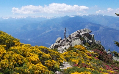
Imagine a journey in a remote, ancient and spiritual region of Japan. Hiking through an endless sea of tree-covered mountains with hidden valleys, waterfalls and traditional rural villages. After a day of invigorating walking, you’ve soaked in the steaming-hot onsen, dressed in a traditional robe and enjoyed a delicious meal of the freshest local produce before falling into a deep sleep on your futon. This is life on the Kumano Kodo, a network of ancient pilgrimage trails on the Kii Peninsula, south of Osaka.
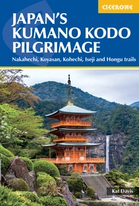
Japan's Kumano Kodo Pilgrimage
Nakahechi, Koyasan, Kohechi, Iseji and Hongu trails
£18.95
Guidebook to walking Japan's Kumano Kodo, a network of ancient pilgrimage trails on the Kii Peninsula, south of Osaka. Covering the Nakahechi, Kohechi and Iseji trails, as well as Koyasan and the Choishimichi route, the guide has all the practical information needed, along with notes on the routes' rich history and culture.
More information
What is the Kumano Kodo?
The Kumano Kodo 熊野古道, meaning ‘old roads to Kumano’ consists of five pilgrimage routes (the Kiiji, Nakahechi, Ohechi, Kohechi and Iseji) that were historically used to reach the three grand shrines of Kumano (Kumano Hongu Taisha, Kumano Hayatama Taisha and Kumano Nachi Taisha), known collectively as the Kumano Sanzan.
What is the history of the Kumano Kodo?
It all started in the year 907 when Emperor Uda made a pilgrimage to the region. Uda was followed by over 100 imperial pilgrimages between the years 907 to 1281, during which large imperial processions set out from the ancient capital of Kyoto guided by mountain priests. They would continually stop along the way to perform ritual purification rites to purify their sins, find salvation and be ritually reborn in the Buddhist pure land. The month-long return journeys were strenuous affairs that were mostly undertaken on foot to accumulate religious merit. After this time, the pilgrimage gained popularity with samurai, artists, poets and commoners, and in 2004, the region and its associated pilgrimage trails were designated UNESCO World Heritage. In fact, as Spain’s Camino de Santiago and Japan’s Kumano Kodo are the only two UNESCO-designated hiking trails, they’ve been twinned. Those who walk both are eligible to become ‘dual pilgrims’.
Where is the Kumano Kodo?
The Kumano Kodo is located on Japan’s Kii Peninsula, which is in the Kansai region, due south of Kyoto and Osaka. The closest international airport is Kansai (KIX) and British Airways offers a direct service from London. From here, it’s just a 2½hr train ride to Tanabe, considered the main gateway of the Kumano Kodo Nakahechi route. Alternatively, if you fly into Tokyo, you can take the Shinkansen bullet train south to Osaka and then transfer onto a local train. There are also domestic flights from Tokyo to Osaka and an even closer domestic airport to Tanabe in nearby Shirahama (SHM).
- Flight time from UK: 12–14 hours
- Visa: British citizens do not require a visa for touristic stays of up to 90 days
- Time zone: GMT +9
When is the best time of year to walk the Kumano Kodo?
Spring (March–May) and Autumn (September–November) are the best seasons to walk the Kumano Kodo routes. The rainy season (mid-June–mid-July), typhoon season (May–October) and summer (June–August) are not recommended due to high rain and humidity.
Which Kumano trail to hike?
Imperial processions departed from the old capital of Kyoto, travelling south along the Kiiji route. In Tanabe, this route split into two: the Nakahechi, which headed east through the mountains to reach Kumano Hongu Taisha, and the Ohechi, which followed the coast south-east towards Kumano Nachi Taisha. The Kohechi route connected the Buddhist Shingon Centre of Koyasan to the Kumano Sanzan and the Iseji route connected Ise Grand Shrine with the Kumano Sanzan.
The nature of the Kumano Kodo allows for pilgrimages of varying lengths, from single day hikes to multi-week itineraries, depending on time and fitness. At first glance, the various pilgrimage routes might seem daunting so let’s delve deeper into the key points of each trail.

The Nakahechi Trail
Length: 64km
Days: 4–5
Waymarking: Fantastic bilingual signs
See: Shrines, temples, waterfalls, hot springs, rural villages – this trail has it all!
Terrain: Forest paths (including tree roots/moss-covered stones) and some short sections of quiet roads
Level: Easy to hard; don’t underestimate the distances and make sure to start out early each day
Access: There is a good bus service connecting the trail to the main hubs of Tanabe, Hongu and Shingu
Season: All year round
The Nakahechi was and still is the most popular trail and today this is for a very good reason. The Tanabe Tourist Office has invested a lot of time and effort into waymarking the route brilliantly with bilingual signs. Their website also has downloadable maps, and an online booking service for accommodation, luggage transfers and optional activities. If you have limited time and would like to experience the Kumano Kodo, then this is the trail to hike. The route officially starts at Takijiri-oji, which is a 45-minute bus ride from Tanabe and can be broken down into two full day stages to reach the first of the three grand shrines, Kumano Hongu Taisha.
- Takijiri-oji to Tsugizakura-oji, 16.4km
- Tsugizakura-oji to Kumano Hongu Taisha, 20.6km
You can also break this into three days and ease into the trail as follows:
- Takijiri-oji to Takahara, 3.7km (don’t underestimate this short stage, for some this is the hardest part of the trail to Kumano Hongu Taisha!)
- Takahara to Tsugizakura-oji, 12.7km
- Tsugizakura-oji to Kumano Hongu Taisha, 20.6km
From Kumano Hongu Taisha, imperial processions would typically sail down the Kumano river to reach the second grand shrine, Kumano Hayatama Taisha in the seaside city of Shingu. They would then follow the coast west before turning inland to reach the last shrine, Kumano Nachi Taisha. Most pilgrims these days walk the two-day route from Kumano Hongu Taisha south to Kumano Nachi Taisha and take public transport to reach Kumano Hayatama Taisha in Shingu. However, if you have a spare day in Hongu or in one of the nearby onsen areas (Yunomine/Kawayu/Wataze), it’s quite nice to take the traditional wooden boat down the Kumano River to visit Kumano Hayatama Taisha in the morning and return by bus in the afternoon. The following day you could start the final two-day stage to Kumano Nachi Taisha, thus visiting all three shrines.
- Hongu (Ukegawa) to Koguchi, 12.6km
- Koguchi to Kumano Nachi Taisha, 14.2km
Accommodation along the Nakahechi route includes Japanese-style inns (ryokans/minshuku) as well as guest houses, rental houses and hostels. Although plentiful, accommodation should be booked well in advance during peak periods of spring, autumn and Japanese holiday periods like Golden Week (late April/early May). Your accommodation will also be your source of meals with most including dinner and breakfast, and an option for a take-away lunch (bento). These beautiful Japanese inns, a hot bath at the end of the hiking day and the local delicacies you’ll be served are bound to be a highlight of your trip.
If you have limited time in Japan but are planning to visit Kumano Hongu Taisha, there is a one-day loop walk (16.7km) starting and ending at the shrine. If you have just a morning or afternoon available, the last 7km of this loop walk, which is accessible by bus, also provides a wonderful snapshot of the Nakahechi trail.

The Kohechi Trail
Length: A 63km linear trail between Koyasan and Hongu
Days: 4 (or 1 – stage four: Totsukawa Onsen to Hongu)
Waymarking: Good bilingual signs
See: Wonderful mountain views, a glimpse into hidden valleys, rural villages
Terrain: A challenging, steep, mountainous route for experienced hikers (there are relatively less obstacles underfoot compared with the Nakahechi; however, this trail crosses mountain passes over 1000m each day)
Level: Medium to hard
Access: This is a remote path with very limited public transport access other than to the starting and finishing points of Koyasan and Hongu
Season: April–October
The Kohechi trail was built as the most direct route between two religious centres, the Shingon School of Buddhism in Koyasan and the Kumano grand shrines. The route is a challenging trail crossing mountain passes over 1000m each day and is recommended for experienced hikers. Accommodation is limited at each trailhead and should be booked well in advance as this is also your only source of meals. There is very limited public transportation other than at Koyasan and Hongu and facilities are also limited. However, the Kohechi is a wonderful trail with stunning mountain views that allows you a glimpse into an almost forgotten rural side of Japan. The waymarking allows for you to walk in either direction. Recommended stages are:
- Koyasan to Omata, 16.8km
- Omata to Miura-guchi, 14km
- Miura-guchi to Totsukawa Onsen, 18.3km
- Totsukawa Onsen to Hongu, 14.3km
If you have just one day and would like to experience the Kohechi, then consider stage four from Totsukawa Onsen to Hongu. There is a good bus service between both areas. This stage takes you through the picturesque hill-top Hatenashi village and over Hatenashi-toge Pass, where you’ll be rewarded with views towards Hongu on the descent.

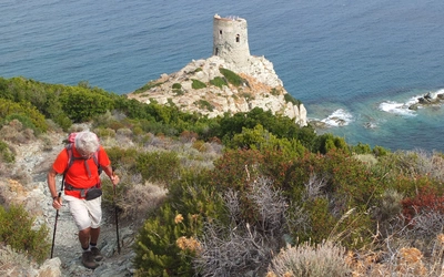
The Iseji Trail
Length: 170km
Days: 7–10
Waymarking: Bilingual waymarks on the UNESCO-designated mountain passes only, no waymarking en route between towns and mountain passes
See: Ise Grand Shrine, temples, mountain passes, coastal views, stunning beaches, rural fishing villages
Terrain: Numerous mountain passes, road walking
Level: Easy to hard
Access: The trail largely follows the JR Kisei train line
Season: Most of this trail could be walked throughout the year; however, it’s not advisable to walk the mountain passes in bad weather
The Iseji trail was constructed to join two major religious centres; Ise Grand Shrine in Mie Prefecture (dedicated to the Sun Goddess Amaterasu, the mythical ancestor of the Emperor) and the Kumano Sanzan in Wakayama Prefecture. This trail was typically used by pilgrims travelling from the north of the country on their pilgrimage to Ise. They then continued onto the Kumano Sanzan. This 170km trail traverses numerous mountain passes with stunning coastal views, crystal blue coves and fishing villages and at times feels like stepping back into an Edo period film set. At the time of writing there was little to no waymarking other than on the mountain passes that are within the UNESCO designation, and limited accommodation options throughout. This makes the route a challenge in itself (with the reward of a wonderful sense of achievement) but as writing a turn-by-turn route guide would amount to a book the size of an encyclopaedia, at this point in time two highlight stages accessible by train have been included in the guide.
- Magose-toge Pass, 6.7km
- Matsumoto-toge Pass, 4.9km

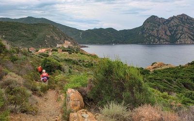
The Ohechi Trail
Length: 120km
Days: 5–7
Waymarking: Frequent leaving Tanabe but dissipate soon after. Make sure to carry a map (available in Japanese-only) if walking this route.
See: Coastal views, rural villages, mountain passes
Terrain: Mountain passes, large sections of dangerous road walking on Route 42
Level: Easy to medium
Access: Train access to many areas of the trail
Season: All year round
The Ohechi trail branched off from the historic Kiiji trail in Tanabe and followed the coastline southeast to Kumano Nachi Taisha. This trail was popular with artists and poets, with stunning coastal views and mountain passes. Today, the trail has largely been absorbed into Route 42 with only a few preserved mountain passes remaining, Tonda-zaka and Nagai-zaka, for example, and is not included in the guide. If you have spare time in Tanabe and would like to walk these sections, maps (Japanese only) are available from the Tanabe Tourism office.
Japan's Kumano Kodo Pilgrimage
Nakahechi, Koyasan, Kohechi, Iseji and Hongu trails
£18.95
Guidebook to walking Japan's Kumano Kodo, a network of ancient pilgrimage trails on the Kii Peninsula, south of Osaka. Covering the Nakahechi, Kohechi and Iseji trails, as well as Koyasan and the Choishimichi route, the guide has all the practical information needed, along with notes on the routes' rich history and culture.
More information