Another Afghanistan: Trekking in the Wakhan Corridor
In the far northeast of Afghanistan lie the mountains of the Wakhan Corridor. This rugged area, tucked between the giants of the Hindu Kush and the Pamirs, has remained untouched by the wars that have battered the country for so many years. Since 2006, the region has been accessible from neighbouring Tajikistan and the most dangerous part of Afghanistan can be avoided. Every year a growing number of western adventurers, including Jan Bakker, cross the border to explore this spectacular mountain landscape by foot, on horse or even on top of a yak.
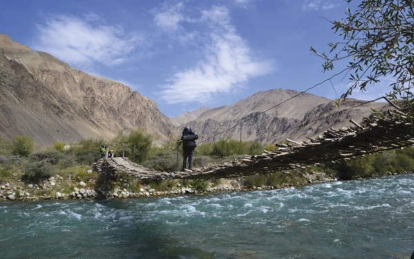
‘Otembik!!!!’ The donkey handler screams at the top of his lungs and points in our direction. We stand on one side of the Wakhan River. On the other side are the villagers of Kurut, the residence of our potential trekking guide Otembik. Without internet or telephone this is the only way of arranging the guide. Our donkey handler assures us that the communication has been successful and informs us that Otembik will probably, Inshallah, meet us at a bridge 3km up the road. Shortly afterwards we see a man running with just a black overnight bag. Is Otembik prepared for a 15-day trek on the high-altitude plateau of the Wakhan Corridor?
Two days earlier we had crossed the border from Tajikistan and set foot on Afghan soil. Friends and family considered us insane to plan a mountain adventure in Afghanistan, and it did feel strange to visit this country for the purpose of a ‘holiday’. Every day we read articles about terrorist attacks, kidnappings and gunfights.
Buffer zone
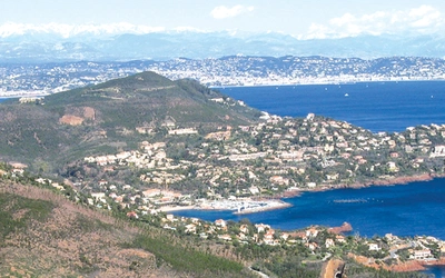
The Wakhan Corridor is a strip of land in the far northeast of Afghanistan. It was created as a buffer zone during ‘The Great Game’, the political shadow-play between the Russians and the British Empire. Centuries before, the Venice-based tradesman and explorer Marco Polo passed the Wakhan on his journey to China. The area, resembling a panhandle, is surrounded by the mighty mountain ranges of the Hindu Kush and the Pamirs, and in some parts of the Corridor the borders of Tajikistan and Pakistan are only 8km apart. Over the past two decades the Taliban, Al Qaida and foreign troops have ignored the 380km long corridor. Perhaps the Wakhan is too sparsely populated, too inhospitable. The fact is that every year around 100 western tourists visit this relatively safe territory to walk, climb and ride horses.
In the border town of Ishkashim it takes a whole morning to arrange the walking permits. It is time consuming because each permit is hand written. There is no option to speed up the process. Part of the ritual of application and approval is to slowly sip cups of tea. We had expected an overkill of bureaucracy to obtain the necessary documents – and we would not have been surprised to have been asked for a bribe. However, the authorities love the fact that we are visiting their country and are extremely friendly.
A few cups of tea and four bits of paper later, we are ready for the two-day ‘bone-crushing’ jeep ride to Sarhad-e-Broghil – the end of the ‘road’ and the starting point of our trek.
The monsoon rains in Pakistan have had an effect on the north of Afghanistan, and the Panj River is full. About half way along the road, we can no longer continue by car. The road has been completely washed away by the river. Our Toyota Landcruiser cannot cross the white-water careering down from the Hindu Kush. That means an additional 90km of trekking by horse and donkey, arranged by our driver Waffiallah. The benefit of this is that it enables us to get a rare insight into day-to-day living in the Wakhan Valley that we otherwise would have bypassed in the car.
We estimate Otembik’s age at around 40. However, we discover his actual age is only 28. Life in this barren region has clearly taken its toll. Winters last eight months of the year and even in summer snowfall is a possibility. As soon as the snow has melted the Wakhi, as Otembik’s ethnic group is called, prepare for the next winter. The diet in the Wakhan is monotonous: bread, tea, yak milk and rock salt. Vegetables and fruit are a luxury. The freeze-dried food we brought from the UK is a welcome addition.
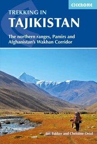
Trekking in Tajikistan
The northern ranges, Pamirs and Afghanistan's Wakhan Corridor
£22.95
Guidebook to trekking in Tajikistan and Afghanistan. Contains 21 treks exploring 5 different mountain areas, including the Northern Ranges, Pamir Mountains and Afghanistan's Wakhan Corridor. Also includes a handful of shorter day hikes. With advice on trekking, backpacking equipment, permits and visas, and transport.
More informationWilderness, desolation and purity
Sarhad-e-Broghil (3265m above sea level) lies at the end of the wide Wakhan valley and is the initial starting point for the trek. To the south a path winds up the Broghil Pass that continues into Pakistan. Further east a seemingly impenetrable mountain range blocks the passage. The landscape is wilderness, desolation and purity. Curtains of dust and sand form numerous dust devils. The mountain summits (reaching over 6000m) are covered in a permanent blanket of snow and ice. The villages, however, look very charming, and the surrounding fields are coloured by yellow rape seed and barley and are flanked by high poplars. The red robes of the Wakhi women add even more colour to the picture.
We stay at a guesthouse that was constructed with the help of the Aga Khan Foundation, an NGO that focuses on development assistance in central Asia. 50 Afghani (approximately US$1 gives us entrance to the village hot spring. In the meantime, Otembik is searching for a yak to accompany us during the trek. This long-haired pack animal resembles the Highland Cow and can easily carry loads of more than 100kg. In addition, yaks function at altitudes up to 5500m. These features are essential for this expedition: we’ll pass a number of mountain passes over 4800m and carry over 50kg of food and equipment. Otembik returns with the yak and its owner Safdar and our team is complete.
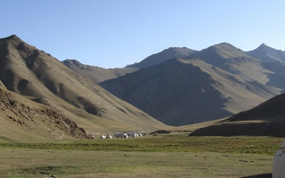
It will take us four days, heading eastwards, to enter a 4000m high plateau called Little Pamir. Ironically, nothing is Little about these mountains: every summit is over 5000m and the plateau itself is enormous. Fortunately, the journey runs smoothly. The paths are in good shape, and we walk for a maximum of seven hours a day. The gradual ascent allows us to acclimatise to the thinning air. Otembik knows the route inside out. We set our camps in spectacular places that are marked as villages on the map but in reality are little more than ruins. After days of wading through ice cold rivers and a whipping bad-e Wakhan (the 120-days wind) we reach the barren and empty high-altitude plateau.
The Little Pamir plateau, with the azure Chaqmaqtin Lake at its epicentre, is inhabited by an ethnic group of Kirgiz nomads. Trade in fat-tailed sheep and yaks are the main sources of income. Life is extremely tough for the 2000 people living on the plateau. It was once more populated, but in 1978, just before the invasion by Soviet troops, a large number of Kirgiz fled to the eastern part of Turkey. This mass migration is locally known as The Last Exodus.
Temperatures plummet down to minus 30 degrees Celsius and dried yak dung is the only form of fuel to heat the yurts.
Due to the lack of access to medical facilities and endemic malnutrition, the Wakhan Corridor has one of the highest maternal mortality rates in the world (160 of every 1000 babies do not survive birth).
At 5am we unzip the tent to see if the previously unsettled weather has improved. The day before the plateau was completely covered in clouds and it rained incessantly. We can’t believe what we see. Everything is covered in a thick blanket of snow and it is only the first week in September! According to Otembik, this happens even in mid-summer. The melting snow transforms the route to Chaqmaqtin Lake into a pool of mud. After six hours of ploughing through this, we pitch the tent on the immense plain that locals call Bam-I-Dunya meaning ‘Roof of the World’. To the south, virgin, razor-sharp mountain peaks of the Hindu Kush dominate the skyline. To the north, the rounded mountains of the Pamirs define the border with Tajikistan. In the far distance (about six days of walking) lies the forbidden border zone with Chinese Xinjiang.
Safdar invited us to his birth village Showr. However, we ‘only’ have to cross a 4600m high mountain pass to reach it. Upon arrival, in a mud house that is filled with smoke we are welcomed with yak butter tea and bread. It is 10 September, the end of Ramadan, and in the rest of Afghanistan Eid is strictly observed. Here there is no sign of the celebration – at this altitude other priorities apply.
A number of strenuous walking days are ahead of us. The 4905m high Shpodkis-Uween pass is the biggest challenge. A day later we climb up the Kotal-e-Qarabel pass; at 4820m it is still higher than the summit of Mont Blanc.
Completely covered in Gore-Tex and sturdy mountain boots we are overtaken by a sheep herder, in sandals…
We use a Russian map that shows a beautiful area with lakes and high peaks just north of Sarhad. No paths are marked on the map and Otembik and Safdar have never been in this area. The altitude lines suggest that the approach to the lakes is possible. We decide to go for it and follow the banks of the raging river. A number of deep gorges threaten the plans. Again, Otembik proves he is a knowledgeable guide. He navigates us along the slopes of the river valley and gets us to the planned camping spot – at 4600m, the highest camp of the trek.
The lengthy stay at this altitude starts to affect our health. We are having trouble eating the freeze-dried food. On a daily basis, we burn more calories than we get put back into our systems. At night we cough without end. However, when we see the tent pitched by a perfectly still turquoise lake, surrounded by an array of breathtaking mountain giants, we take these small inconveniences for granted.
After 12 days of trekking we return to Sarhad-e-Broghil. We hope the road is open again so we can cross the border back into Tajikistan. Inshallah.
Practical information
Trekking season and climate
The best months to go trekking in the Wakhan Corridor are July until September. However, since the majority of the trek is higher than 4000m above sea level you can expect snowfall year-round. Most high passes (>4800m) are permanently snowbound and night temperatures can dip easily below 0[Symbol]C, even in summer. Daytime can be quite nice and balmy.
Equipment and supplies
Unless you do an organised expedition, you need to be completely self-sufficient. The availability of trekking equipment is quite minimal in Tajikistan and not at all in Afghanistan. The best places to buy food supplies are Dushanbe and Khorog. You can buy some basic supplies in Ishkashim. Bring food for the guide and yak herder as well; we brought an extra tent too to make sure they had a proper shelter throughout the trek. Bringing a satellite phone or satellite messenger/beacon is recommended.
Independent v organised
A guide can be hard to arrange as there aren’t many around in the Wakhan. If you allow enough time to arrange permits, guides and transport it is not too difficult to organise all this yourself. The trek itself is not technical but does involve walking at a high altitude for at least a week. A yak can be hired for riding (very comfy!). Otherwise, there are two British organisations that do trips in this part of the world, Secret Compass and Untamed Borders.
Health
Before you go check with your GP which vaccinations you need for this area. Always purify or filter the water to prevent giardia. Altitude sickness is a real risk as you will be trekking at high altitudes. Acclimatising by ascending gradually is the best way to avoid problems. Bear in mind that there are no medical facilities in the entire Wakhan Corridor. Since you will be days away from the closest medical post bring an extensive first aid kit with you.
Maps, guides and websites
The majority of this trek is covered in the Cicerone guidebook Trekking in Tajikistan, co-authored by the author of this article. It provides all the information you need to know about organising a trekking expedition like this independently. The best maps available are Russian topographical maps that were created in the early 1990s. These can be downloaded on the website.