Walking in the Altai mountains of Russia and Mongolia

Mike Wells and his partner Christine Gordon spent two weeks in the Altai mountains, trekking to mountain summits, hidden lakes and remote valleys on the borders of Russia and Mongolia.
Straddling the four country borders of China, Kazakhstan, Mongolia and Russia, the Altai mountains rise to snow-capped summits in excess of 4000 metres. When planning our trip, we had hoped to walk in all four parts of the range, but travel restrictions between the mountains in China and Kazakhstan restricted our journey to the Mongolian and Russian Altai.
Even here, route planning was influenced by the need to obtain border permits to walk in areas that are deemed sensitive from a military point of view. In Russia, where permits can take two months to obtain, we restricted our walking to areas not needing permits. In Mongolia obtaining permits is much easier; as a result, we were less restricted. In both countries the highest mountains are generally climbers’ mountains requiring ropes and equipment plus the route-finding knowledge of a local guide. As we are walkers not climbers (the most challenging climb I have done is the rather innocuous ascent of Pillar rock in the English Lake District, while my partner has gone a little further and assailed Skye’s Inaccessible Pinnacle), we avoided these so-called technical mountains. We did, however, come across a Swiss group who were climbing with skis to the top of the five highest peaks in the Mongolian Altai before skiing down each one onto the glacier below!
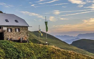
The Russian Altai
In the 1930s the Soviet government used political prisoners from gulag prison camps to construct the 963km-long Chuysky Tract, a highway that follows an ancient trading route between Russia and China through Siberia and Mongolia. The road was built primarily for military purposes and during the communist period was closed to foreign visitors. Since 1991 this road between the western Siberian capital Novosibirsk through the Altai mountains to the border of Mongolia has been upgraded with an asphalt surface throughout and now climbs gently over two mountain passes.
It has been described by National Geographic as one of the top 10 scenic roads in the world and provides fast and convenient access to the semi-autonomous Russian Respublika Altai.
As a result, the area has become a popular vacation destination for Russian families, although it is little visited by non-Russians.
The principal resort towns of Artybash and Chemal lie in separate side valleys north of the Chuysky Tract. In laidback Artybash there are boat trips to waterfalls surrounding lake Teletskoe, the second largest lake in Siberia after Baikal, and horse riding in the surrounding hills. We took a 70km boat trip to the head of the lake and then followed a trail into the hills to visit mushroom rock formations where thousands of hard rock capstones sit on top of eroded pillars of softer conglomerate. For the adrenalin-seekers, in-your-face Chemal has zip-lines, bungee jumps, kayaking and opportunities to go white-water rafting.
The more serious walking opportunities lie further south along the Chuysky Tract as it climbs up and through the Altai mountains. The most challenging walks require border permits, but there are two good day walks for which permits are not needed that start from trailheads on or near the main road. The first, a 25km round trip trek to the summit of Mt Sarlyk, starts from the top of the Seminsky pass (Chuysky km post 583) at 1717m, and rises nearly 800m through thick taiga (Siberian birch and pine forest) and open mountainside to a bleak rounded summit at 2502m.
Trekking to the Blue Lake
Further west, beyond the Chike-Taman pass, is the start-off point for a popular full-day return walk to spectacular Blue Lake in a mountain-surrounded bowl below the slopes of snow- covered Mt Akturu. Getting to the start of the trail is an endurance feat in itself. Four-wheel-drive vehicles (Jeeps, Uaz Furgons, Landcruisers and ex-army personnel carriers) start from Kuray village (1490m, Chuysky km post 826) and take you on a tortuous 2hr/32km ride at first across open Steppe then 600m up through the taiga forest on deeply rutted dirt and mud roads and across two wide rivers (by ford, no bridges).
Straps hanging from the roof help passengers cling on and avoid being thrown from their seats. At the trailhead (2105m), where an obvious and partially waymarked track continues up through the taiga, it is 5.5km to Blue lake. The trail passes the meltwater tails of two small glaciers then ascends a steep, rocky moraine slope to reach a third, larger glacier. Continuing upwards the trail runs along the side of this glacier, partly on ice and partly on bedrock. Although we walked on a warm sunny day in late June, the glacier was covered by a thin coat of fresh snow, which had fallen two days previously. This gave it a dazzlingly white appearance, marked by patches of grey where either the fresh snow had melted, or walkers’ boots had brushed it away revealing the dirty winter snow beneath. Finally, the path turns steeply up a lateral moraine to reach a small ridge at 2840m overlooking Blue Lake about 15m below.
The lake itself was covered by a thin veneer of soft ice but this did not stop hardened Russians, including Dmitry, one of our party, from stripping-off and diving in for an invigorating icy bath. I declined the opportunity!
We ate a picnic lunch admiring the view of snow-covered mountains all around, with Mt Akturu (4070m) rising behind, then made our way down by the same route. The round trip took 10 hours, including 2hr up and down by four-wheel-drive vehicle and an hour at the lake. Yuri, our guide, had set a target of three hours for us to reach the top of the first moraine; outside this limit we would have turned back without reaching the lake. He was concerned that at our ages (70 and slightly younger) we would not make it. When we passed the mark after 1hr 45min, he admitted he had underestimated our abilities. Over 50 other people had set off that morning in a dozen vehicles. Only 20 reached the lake. Most of the rest had struggled up the first moraine in inappropriate footwear (trainers, sandals) then given up when they saw the glacier and second moraine rising ahead. Properly suited and booted and with walking poles, we found the walk challenging but not difficult.
Mongolian Altai
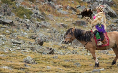
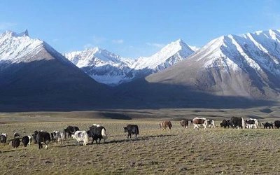
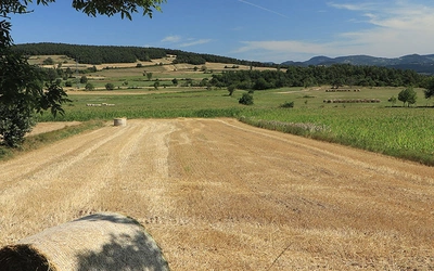
Compared with Russia, the Altai in Mongolia is far less developed in terms of communications, tourist infrastructure and economic development. Once over the border, a surfaced road continues for nearly 100km to Ulgii, the main town of Bayan Olgii aimag (county). Beyond here roads give way to rough four-wheel-drive dirt tracks that wind across open steppe and through the mountains. There are a few villages, but in this part of the world the nomadic lifestyle is king and the steppe countryside of sparse grasses is dotted in summer with occasional ger camps and the animal herds of their occupants (ger is the Mongolian name for a Yurt, a round tent used by nomadic tribespeople throughout central Asia).
The ger dwellers in Altai do not speak Mongolian, nor are they fully nomadic. The majority are Kazakh-speaking Muslims, while some are Tuvan speakers from a region of Russia bordering Mongolia. They divide their year between three homes, two of which are permanent and used for nine months. Their winter home is a building with barns in a village or low down the valley, while in spring and autumn they live in a wooden cabin part-way up the valley, often with their ger outside. In summer they pitch the ger at the head of the valley while their animals are grazing at higher altitudes. Summer camps are often family affairs with up to five gers holding a group of parents, married offspring and grandchildren.
Within a day’s 4wd drive (about 200km) from Ulgii are two national parks in stunning countryside with extensive walking opportunities; Tsambagarav Uul south east of town and Tavn Bogd to the west. We spent a week trekking in the latter, following a recognised but faint trail that passed within sight of Khuiten Uul (4374m), Mongolia’s highest mountain, which straddles the three-way border between China, Mongolia and Russia.
Trekking in Tavn Bogd national park
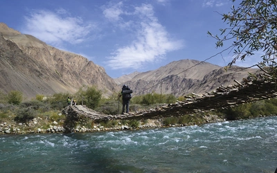
We did it the easy way, using a travel agency to obtain border permits, provide a guide (unaccompanied trekking is forbidden in border areas) and provide tents, meals and toilet facilities (including a hot shower!) in the wilderness. We walked 106km in six days, unencumbered by luggage, covering part of a nine-day walk from the park ranger station in Sogoo Gol valley to Khoton nuur lake.
Our bags, tent, toilet and shower, together with our food, cook and her cooking tent, were carried by two heavily loaded, oft-complaining camels and their herdsmen. These would pass us each lunchtime, on their way to set up camp ahead of us that night.
Our route first took us to Khuiten Uul base camp (3088m) beside the Potanii glacier at the foot of Mt Malchin (4050m), the lowest of five sacred peaks in the range (Tavn Bogd translates as Five Saints). The other four summits, including Khuiten Uul, are all technical ascents requiring ropes and equipment, but Malchin can be walked up following a steep but reasonably straightforward zig-zag path, although the altitude makes this a strenuous task. Round-trip from base camp takes about eight hours. The Mongolia/Russia border runs over the summit and there are distant views of China. We walked up with Saule, a Lithuanian girl whose father had been a political prisoner in a soviet gulag. Born after the fall of the Soviet Union, she had never visited Russia until she put one foot over the border on the top of Malchin.
A floral wonderland
From Malchin we walked down one valley and up another, passing occasional ger camps. The valleys were heavily grazed by the nomadic herders’ sheep, goats, cows, horses and yaks. June and July are the wettest months in the Altai but the sparseness of grass and the lack of wildflowers suggest that the steppe is being overgrazed. At the head of the second valley we climbed over a pass at 3150m, crossing a deep snowfield where a route had been cut through head-high banks of snow to allow the passage of horses and camels. Descending into the next valley, there was a remarkable change in vegetation. This valley is a protected zone, with grazing prohibited and thus no nomads. It had lush grasses with a vast profusion of wildflowers in pink, red, blue, yellow and white, including such alpine rarities as edelweiss and gentian.
This abundance continued into Bear valley, a much bigger valley where we camped beside a wide river, fast flowing with milky white glacial water. Continuing the next morning we descended from alpine meadows into open birch forest as we crossed a series of moraines, passing heart-shaped Green Lake, formed behind a lateral moraine with stunning reflections of tree-covered slopes and snow-capped mountains. The mountain ridge across the valley to our right formed the border between Mongolia and China, which at the narrowest point was only 3km away, although nearly 1000m above us. We ended our walk where the valley widened with gers on the riverbank and animals grazing the meadows, now devoid again of flowers. Although our walk ended here, the trail continues for nearly 60km (three more days’ walking) past Khoton lake, which we saw from the windows of a 4wd truck as we bounced our way for six hours back to Ulgii.
Practical considerations
There are no direct flights from the UK to Mongolia or the Russian Altai region. We flew to Moscow and followed the trans-Siberian railway route for two weeks to Novosibirsk, Russia’s third-largest city and the jumping-off point for Siberia and the Altai. Flights from London via Istanbul (Turkish Airlines), Moscow (Aeroflot) or Frankfurt (Lufthansa) give the best connections to Ulaanbataar in Mongolia. There are local airports in Barnaul (Russian Altai) and Ulgii (Mongolian Altai) served by flights from Moscow and Ulaanbataar, respectively.
We used guides in both Russia and Mongolia to reach the remote corners of the Altai. These were booked through travel agencies before departure, although there is a plethora of agencies in Russia (in Novosibirsk or around Gorno-Altaisk) and Mongolia (in both Ulaanbataar the capital and Ulgii the regional centre) that can arrange guides, equipment and border permits.
Outside the main towns, accommodation is very limited. In Russia most tourists stay in campsites composed of small wooden cabins, which occur frequently along the Chuysky Tract highway. In Mongolia there is no accommodation in the mountains. The only options are camping or ger homestays with local families, which can be arranged by local agencies in Ulgii. These agencies can provide tents, sleeping bags and guides and arrange transport into the mountains.
Christine's video of the trekking can be viewed below: