An essential guide to planning your first hut-to-hut trip in the Alps
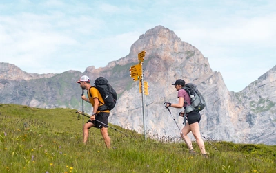
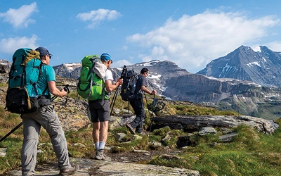
For mountain enthusiasts and multi-day hikers, the allure of the Alps is inevitable, and an alpine trek staying high in mountain huts is an ideal way to explore the region. The huts provide a great atmosphere, safe shelter, good food and interesting company – all the right ingredients for a walking holiday. A hut-to-hut trek allows you to explore further, and venture beyond one valley base. With the right information it's not difficult to organise, and the rewards are great. Here’s everything you need to know to plan your first trip.

What is an Alpine Mountain hut?
Don’t be put off by the word ‘hut’ – these are not camping sheds! A mountain hut can otherwise be known as a refuge in France, rifugio in Italian, cabane in parts of Switzerland, and hütte in German-speaking areas. In Slovenia they are dom or koča. Whatever the name, this extensive network of welcoming shelters will form the glue to your journey as you thread your way through the mountains on an alpine trek.
Most mountain huts are like hostels, usually with a mixture of dormitory accommodation and rooms. In nearly every case toilet and washing facilities will be communal, and occasionally multi-gender. Dormitories nowadays tend to be rooms with between four and twelve separate bunks, although occasionally you will come across some where multiple sleeping spaces are arranged on a long sleeping platform – less appealing, but still a safe bed for the night!
Most mountain huts open during the summer trekking season between mid-June and the end of September, and will have a resident guardian and staff (or family) who prepare and serve meals and refreshments, and generally look after running the hut. The guardian will have an extensive knowledge of the mountains in the vicinity, and be able to give advice on the nature of your intended route the following day, as well as provide suggestions if you need alternatives. Most have a mountain guiding qualification of some sort, so the advice you receive will be reliable. Some huts are more like mountain inns; amazing places far from the nearest road or village, but offering good facilities in a truly magical location.
What facilities and services do mountain huts provide?
Mountain huts come in all shapes, sizes and ages, and many very high or remote huts will often have fewer facilities – but that should definitely not be a reason for missing out on staying in a truly spectacular spot for the night.
Every hut will have the following facilities, although every one is different – sleeping accommodation, toilet and washing facilities, a common room/dining room, and a balcony, terrace or garden outside. Some huts also have small kitchens for guests to use.
Sleeping accommodation and facilities
Dormitory accommodation consists of a mattress, pillow and duvet or blankets per person. You will need your own sleeping bag liner, although you can usually rent one when you arrive. Towels are not generally provided. Dormitories usually have a shelf of alcove for you to store your gear and rucksack, and if you're lucky there may be a small shelf to to act as a bedside table for your headtorch/glasses/watch.
Most huts have showers, however these may not be guaranteed to be either hot or running, as many huts rely on solar power to heat hot water and provide electricity. Try not to be too disappointed – it's almost certainly only for one night!
Hand washing your clothes and socks can generally be done in the afternoon and there is often a washing line outside – or a fence or warm rock to dry things.
Most huts will have electric charging facilities for phones, gps, watches. You will need your own charging cables.
Meals
The best option is to book half board (evening meal and breakfast). A packed lunch or a sandwich can usually be ordered for the following day.
A breakfast of tea/coffee or hot chocolate, cereal, bread and jam is the usual offering. If the hut is accessible by 4x4 vehicles, then you may be lucky and have more options, including yogurt, fruit juice etc.
Lunch in a hut may well be an option if you pass one at around the right time. Lunch can usually include soup, bread and cake or a fruit tart, and once again some huts will be able to provide many more options.
Supper is the highlight, when everyone assembles together. A typical supper will be three or four courses – soup (pasta in Italy), salad, a meat/vegetarian dish with carbohydrate (rice, polenta, potato, pasta), and a simple desert. Cheese may also be offered as an additional course.
Drinks can range from a fully stocked bar to a few standard choices, but you will always be able to get drinking water (even if it has to be bottled), and it's unusual not to be able to get a beer, wine, and various soft drinks, as well as some pretty potent alpine liqueurs!
The dining room
This is the heart of the hut experience. Everyone eats at the same time, and you will start your meal among strangers, and finish as friends. The room will also act as a general common room, where you can eat and drink snacks, spread out maps and make plans. To while away any long afternoons in poor weather here will usually be a good collection of mountain books to browse and board games too.
The boot room and outside
When you arrive, walking poles and boots/shoes remain in the boot room and hut shoes (usually 'Crocks') are provided, or you can wear your own shoes. Wet waterproofs should stay here too, unless there is a drying room provided. If it's good weather, enjoy the late afternoon sunshine outside, usually with fantastic views all around, and watch the sunset and 'alpenglow' at the end of the day.
Where should I start?
You might want to start by following a recognised trek that may well be signed on the ground, or pick one of the treks covered by a Cicerone guidebook. This makes planning easier, as there will be all the information you need in the guidebook, which can often be supplemented by a variety of websites providing additional insight and highlights. You may have visited an area of the alps and enjoyed a few day walks from a valley base, and now plan to explore the region further and make up your own multi-day trek, not confined to accommodation in the valley.
Most people have heard of the Tour of Mont Blanc, circumnavigating the Mont Blanc massif through France, Italy and Switzerland. Views are incredible, and there is a wide range of huts, gîtes and other accommodation, but it's international allure makes it extremely busy, especially during July and August, and accommodation needs to be booked months in advance. It's generally without difficulty and can be completed in around 8-12 days, or even split into two or three shorter treks if necessary. The other trek most people will have heard of is a linear trek from Chamonix to Zermatt, through the Swiss Valais between Mont Blanc and the Matterhorn. This 12-14 day route is more challenging, and encounters some steeper, higher cols, but once again your efforts are rewarded with incredible views, and there are options to split the route into shorter treks.
But you may want to start with something different!
French Alps
The 11-12 day Tour of the Vanoise south of Mont Blanc in France would make a fine start. There are plenty of huts in the superb Vanoise National Park and most are about 3-4 hours walking apart, making it a good area for a family trek, and also gives options for short days, especially useful as you get used to the altitude. It's a beautiful area, with plenty of wildlife, wonderful alpine flowers in early summer, and a few glaciers remain in the higher parts.
Longer, more challenging treks in the French alps include circular tours of the Queyras, the Écrins, and in the Mercantour and Maritime Alps.
Challenge trek: The GR5 Trail through the French Alps – from Lac Léman to Nice or Menton on the Mediterranean coast. This is a wonderful 4-week trek, a journey of some magnitude, but always on good mountain paths, passing through the Savoie, Mont Blanc, Beaufortain, Vanoise, Queyras and Mercantour regions as you head south.
Swiss Alps
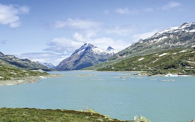
The Tour of the Jungfrau Region in Switzerland is almost guaranteed to get you hooked on this style of multi-day hiking, and with numerous lifts and mountain railways in the area it's perfect to test out how you will enjoy trekking, as you can always easily return to Grindelwald, Wengen, Mürren or Lauterbrunnen for more creature comforts and facilities. The 9-day Tour of the Bernina on the borders of Switzerland and Italy also makes a fine introduction to trekking, provided you have had some experience of alpine walking.
Challenge trek: For a three-week trek with a difference, walk east-west across Switzerland on The Swiss Via Alpina 1. Also known as the Alpine Pass Route, how do you fancy these stats – 16 passes, 400km, 23,000m of ascent. It's as tough as it is rewarding!
Italian Alps
The Italian Alps tend to be a little more challenging, with deep valleys carving into the southern side of the Alps, making for long ascents and descents between huts and villages. Ideal for more experienced or very fit walkers, there is much to enjoy, not least the scenery, friendly Italian hospitality and great food! In the Dolomites, Alta Via 1 is the most well-known trek, taking under two weeks to complete, and only a little harder than the Tour of Mont Blanc. The unique landscape of towering limestone is very special. Don't confuse yourself with Alta Via 1 Giant's trail – this is a more challenging proposition, split into two parts – a northern section from the foot of Monte Rosa westwards, then into the Gran Paradiso. The paths are steep, the cols are high, but well within the ability of more experienced alpine walkers, as is the Tour of Valmalenco just to the south of the Swiss border and the Tour of Monte Rosa, which visits both Italian and Swiss valleys.
Challenge trek: The equivalent of the GR5 through the French alps, the Grande Traversata delle Alpi (GTA) is another epic six-week trek through the Italian alps between the Nufenen Pass near Monte Rosa and Ventimiglia on the Mediterranean coast. Vital stats are 809km, nearly 60,000m of ascent.
Austrian Alps
For the first time the Austrian Alps take a lot of beating. Heights are modest, but the mountains look big and the ambience is something you’ll never forget.
Try trekking in the Stubai Alps southeast of Innsbruck, or if you feel you can handle more challenge, then treks in the nearby Zillertal and Hohe Tauern may be more suitable for experienced alpine walkers who have good fitness. Some of these treks can involve glacier crossings and scrambles.
Challenge trek: The Adlerweg (Eagle's Way) through the Austrian Tyrol is a 324km trekking route. The 24 stages described in the Cicerone guide help you choose between route options, ranging from white (easy), red (difficult) or black (challenging and technical).
Slovenian Alps
In Slovenia the alps become rugged and often devoid of water supplies, except in the mountain huts. Routes are mainly more challenging, although there are many parts that are well within the scope of a first time alpine trek. The Juliana Trail is 330km long, a circular trek around the Triglav national park. Exploring the Julian alps, this trek can be split into shorter trips, or hiked in around three weeks. It's a relatively easy hike with good marked trails, however most of the overnight stays are in small towns and mountain villages, so you will have little mountain hut experience on this trek.
Challenge trek: The Slovene Mountain Trail or Transverzala takes a 550km route across Slovenia. Beginning at Maribor near the Austrian border to Ankaran on the Adriatic coast. Some sections are very technical and strenuous, so this is only suitable for more experienced alpine trekkers.
Can I plan my own trek?
In short, yes!
Pick an area of the alps that interests you, whether an area you have previously visited, or somewhere new to explore, and get planning! Look for interesting features or villages that you think will be worthwhile visiting, determine how long you have available and where you will be able to easily start and finish, and you're on your way to devising your very own trek.
Maps: Hiking maps, both online and sheet maps will normally show the location of mountain refuges. As a rule of thumb for walkers of average ability, if you're looking at a 1:50,000 sheet map you'll probably manage one handspan distance in a day (or two handspans on a 1:25,000 scale). It's a quick way to get things plotted out without getting too technical at this stage. Next look at the terrain between these points, and adjust if you think it's going to be easier or harder that most of the other days. It you're using online mapping you will generally be able to plot a route between two points to determine the distance, time and ascent/descent quite easily.
Suggested useful websites are at the bottom of this page.
Top 10 tips for a first-time Alpine trekker...
- Accommodation Try to book your mountain huts well ahead of your trip dates. This is especially important if you are planning to visit a popular area or do a popular trek. For the Tour of Mont Blanc, Chamonix to Zermatt or Alta Via 1 in the Dolomites, plan and book your accommodation as soon as you know your dates, ideally by February for a summer trek, by March for the shoulder season.
- Get into good shape To truly enjoy your trek, you will need to be fit enough to tackle each day, which will often involve 800m or more of up and down and 15–20km, and know you can do the same tomorrow – and the day after! Build up fitness over two or three months, gradually increasing walking distance and difficulty, and practice with your boots and backpack. Make sure everything fits well. Ideally, include a 2–3 day walking trip towards the end of your training.
- Choose the best gear Outdoor gear is often expensive, but excellent brands can often be purchased at a discount or second hand. You will need boots with a good sole, as rocks can be slippery, sharp and rough. Ideally waterproof for rain or snow, make sure they're comfortable and a good fit. Waterproof jacket and trousers are essential even in the summer – ensure they are just that – waterproof – as you might be out all day in heavy rain. A rucksack cover is useful too. Walking poles are a good idea, to make long descents more comfortable, and help with ascents too, but make sure you are happy using them, and try to get the lightest, (but strong) pair you can afford. You will need a well-fitting rucksack to carry all your gear, a 25–35l pack is ideal (otherwise you will be tempted to carry too much!)
- Keep your pack light Remember, the more you carry, the harder it is – just imagine carrying two carrier bags of shopping up 800m! Tips to reduce weight – keep all toiletries small (use multi-purpose shower gel/shampoo/wash), keep electronic gadgets and chargers to a minimum as these can be heavy, use a silk sleeping liner and lightweight pack towel, choose clothing and shoes that are light and packable, (but make sure you have warm clothing too), plan to wash clothing as you go.
- Stay well organised and prepared Read up the route description the night before and make a mental note of any key points along the way (steep sections of climbing, shelters, water, turns and alternative routes that might be missed in bad weather). Check the suggested timings for your route and be aware of your progress. Check out the weather forecast and pack waterproofs near the top of your pack if rain is likely. Organise your gear in the rucksack in separate bags (ideally waterproof stuff sacks) – eg,. clothing, outer gear, things you will need in the refuge, sundries, food.
- Start early, finish early Start each day as soon as you can after breakfast, so that you are well on your way before summer temperatures get too hot. Try to keep cool and wear a sunhat if the sun is very intense and aim to arrive at your next accommodation in good time – early afternoon, ideally. That will allow maximum time to rest and recover, read up and plan the route for tomorrow and to do all chores.
- Walking each day Take things steady, if possible, for the first two or three days, as this will help you recover from travelling, acclimatise to the altitude and avoid injuries and muscle strains that could ruin your trek later on. Try to settle into a steady pace that you can sustain. Stop for a rest regularly (it’s not a race!) and keep eating small snacks to maintain energy levels. Carry a minimum of 1litre of water and keep well hydrated. Enjoy the views and take plenty of photos, but if the weather is challenging, concentrate on following the route.
- Staying in a refuge The guardian will confirm your reservation and show you to your room or allocated mattress in a dormitory. Lay out your bedding while it’s easy to see what you are doing, then, if available, have a shower and do any washing. It’s hard to prioritise when all you want is to sit down and have a beer, but washing will dry well in late- afternoon sunshine and there are usually spaces on a line or fence. Sit in your allocated seat at mealtimes and enjoy the company. Pay at the end of the evening and keep quiet after 9pm. Ensure you have everything packed away before leaving – it’s easy to miss small things like toothpaste, a charger, gloves…or the washing still on the line!
- About the weather You may be lucky and enjoy cloudless skies for the entire trip, doubtless running out of suntan cream by around halfway. Sun exposure in the high mountains is more intense, so ensure you have high-factor protection. If a wet-weather system passes through, it may last for a day or two but is likely to clear quickly. Thunderstorms in the late afternoon during high summer are always possible, another good reason for starting out early and arriving during the afternoon. Snow and hail showers can occur at any time of year in the Alps, covering paths and signs and especially making high passes difficult and very slippery underfoot.
- Is it cheating to use lifts and buses? In some instances, it may be a good idea to take advantage of lifts – to shorten an otherwise long or very wet day, or to help with a long steep descent. Buses can also take some of the strain, especially if you are on a tight schedule. Your trek is YOURS. There are no prizes for the longest, shortest or most difficult treks, you choose what suits you and your companions, and enjoy it for what it is.
Useful resources
UK Alpine club membership and insurance
Consider joining the UK branch of the Austrian Alpine Club – British section for reduced overnight fees in all alpine club huts. Your AAC membership also includes mountain rescue insurance cover. Membership of the British Mountaineering Council will also qualify you for reduced overnight fees in all alpine club huts, and BMC members can obtain suitable rescue an mountain insurance cover at an additional cost.
Maps
Suggested maps are always listed in Cicerone guidebooks and in website entries for each book. For France, IGN is the national mapping company. Hiking maps are available at 1:25,000 and 1:50,000 scales, and show mountain huts, mountain paths and useful facilities. For Italy, Compass and Tabacco maps are a good choice. The Swiss national mapping is excellent, showing graded mountain paths and huts. Their online mapping is also very useful provided you download the paths layer (otherwise all paths are just a morass of dotted black lines!).
Databases of mountain huts across the Alps
Club Arc Alpin: https://www.club-arc-alpin This site provides links to alpine club sites with hut databases for France, Germany, Italy, Switzerland, Austria and Slovenia
Direct links
Swiss Alpine Club huts: https://www.sac-cas.ch/en/huts
French Alpine Club huts: https://www.ffcam.fr
Italian Alpine Club huts: https://rifugi.cai.it/
Austrian Alpine Club huts: https://www.alpenverein.at