Five of the best short walks on the Isle of Mull: wildlife, castles and Hebridean beaches
The Isle of Mull, reached by CalMac ferry from Oban on the west coast of Scotland, combines dramatic volcanic coastline, ancient woodland and white-sand Atlantic beaches within a compact island landscape. Terry Marsh's guidebook 15 Short Walks on the Isle of Mull covers 15 routes across Mull, neighbouring Ulva and the sacred island of Iona, with routes ranging from 1.5 to 10.5 km and typically taking under three hours. The five walks below offer a cross-section of what the island does best: ornamental lakeshore, lost villages, a hilltop coastal fort, island exploration and a circuit of Iona's wild southern coast. (Date updated: June 2026. Guidebook Updated: August 2024)
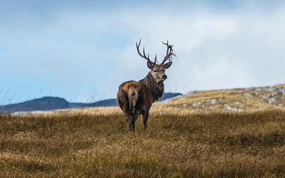
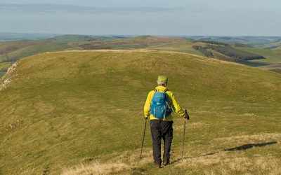
These walks suit beginners, families and anyone looking for a rewarding half-day out without challenging terrain or complicated navigation. All five are easy to moderate, and most can be enjoyed year-round, though out-of-season visits bring quieter roads and a better chance of spotting the island's celebrated wildlife, including white-tailed eagles, otters and seals.
How to get to the Isle of Mull?
The main gateway to Mull is the CalMac ferry from Oban on the Scottish mainland to Craignure, which takes approximately 45 minutes. A shorter crossing runs between Lochaline and Fishnish on the east of the island. Oban is served by ScotRail trains from Glasgow Queen Street. Driving from Glasgow, the A82 north to Tyndrum and then the A85 west to Oban takes around two and a half hours. Tobermory, the island's only town and the base for several walks in the guidebook, is roughly 35 minutes' drive north of Craignure. For Walk 4, a small passenger ferry connects the Mull shore to Ulva. For Walk 5, a CalMac ferry runs from Fionnphort on Mull's southwest tip to Iona.
For longer day walks, Walking on Mull, Coll and Tiree is also available from Cicerone.
15 Short Walks on the Isle of Mull
£9.95
Discover 15 of the best short walks on the Isle of Mull, including Ulva and Iona. Each walk comes with easy-to-read Ordnance Survey maps, clear route description and lots of images, plus information on beauty spots and refreshment stops. No challenging terrain or complicated navigation means walks can be enjoyed by everyone.
More information"Mull is not over-endowed with conventional tourist attractions; it’s not that sort of place. You come here for the walking, the wildlife and the stunning scenery of a landscape 60 million years and more in the making. Tobermory is the main centre, though most visitors will arrive either at Craignure from Oban, or the longer but more scenic route via Lochaline to Fishnish."
— Terry Marsh

Aros Park
Summary: A circular walk around Tobermory Bay and through estate woodland to an ornamental lake, with picture-postcard views back to Tobermory
Start/finish: Aros Park, Tobermory
Time: 1hr 30min
Distance: 5.5 km (3.5 miles)
Climb: 190m
Aros Park serves as Tobermory's green lung, a managed estate woodland that draws visitors in all seasons for its rich canopy of ash, rowan, hazel, birch, beech, oak and various pine, with rhododendron providing colour in spring. The centrepiece is an ornamental lake carpeted with water lilies, a serene contrast to the busy harbourside a short walk away. In late summer, the woodland edges offer a bounty of brambles for those who time their visit well.
The route loops around Tobermory Bay before climbing into the estate woodland, rewarding walkers with picture-postcard views back across the harbour to Tobermory's famous row of brightly painted houses. The path is well-surfaced and straightforward throughout, making this one of the most accessible walks in the guidebook and an ideal first outing for those new to Mull.
Best time to visit: Spring for rhododendron colour and birdsong; late summer for brambles and the warmest light on Tobermory's harbourside. Pleasant year-round as the woodland provides shelter in poor weather.

Ardmore Shore Trail
Summary: A poignant walk through abandoned villages and cleared woodland, now rich with wildflowers and wildlife
Start/finish: Ardmore forest car park
Time: 2hr
Distance: 7.5 km (4.5 miles)
Climb: 170m
This walk is heavy with sorrow and history, yet it is a delightful amble offering plentiful opportunity to observe wildlife. Ardmore was once a settlement of 14 townships, a cluster of agricultural smallholdings buried under commercial forestry in the 20th century. Nearby Penalbanach, a 19th-century farm, suffered the same fate, but as the forest has now been largely cleared, fern-clad, roofless dwellings survive as a quiet reminder that people once lived and worked on this stretch of Mull's coastline.
The route follows the shore through recovering open ground where the cleared forest has given way to wildflowers and wildlife, the landscape carrying an atmosphere of loss that is nonetheless beautiful in its own way. With no cafes on the route itself, the nearest refreshment options are Sgriob-ruadh Farm and Tobermory, both worth seeking out before or after the walk.
Best time to visit: Late spring and early summer, when the recovering woodland ground is at its most colourful and the wildlife is most active. The coastal sections offer good birdwatching at any time of year.

Glengorm Castle and Dùn Ara
Summary: An easy walk to the remains of a coastal fort, passing standing stones and a 19th-century castle
Start/finish: Glengorm Castle
Time: 2hr
Distance: 6 km (3.75 miles)
Climb: 135m
The walk begins at Glengorm Castle, a 19th-century pile at the northern tip of Mull, and wanders through forest-cleared areas that now open out to rolling countryside views before crossing undulating pastureland to Dùn Ara, a small Iron Age fort set dramatically on a hilly knuckle overlooking the sea. It is the kind of place you could linger for hours, sea-watching for the wildlife that moves through these waters.
Standing stones mark the route between the castle and the fort, adding another layer of antiquity to a walk that already spans several thousand years of human activity. The estate cafe at Glengorm provides a welcome stop towards the end of the route, and the dedicated walkers' car park just inside the castle grounds is free to use. The cafe here is open from March to October.
Best time to visit: Spring and summer for the best visibility from Dùn Ara and the longest evenings for sea-watching. The estate cafe makes this a particularly appealing choice when the weather is uncertain.

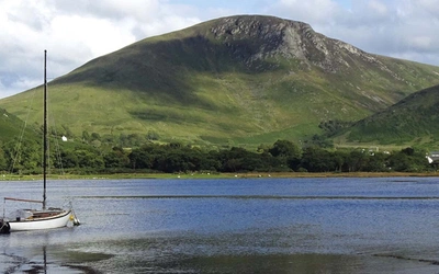
Livingstone Croft Trail
Summary: A delightful wander around the island of Ulva, passing the ancestral croft of a Victorian explorer, with fine views of Ben More
Start/finish: The Boathouse, Ulva
Time: 2hr
Distance: 8 km (5 miles)
Climb: 225m
Ferry required: Ulva is reached by a small passenger ferry from the Mull shore. Check current crossing times before visiting, as the service is seasonal.
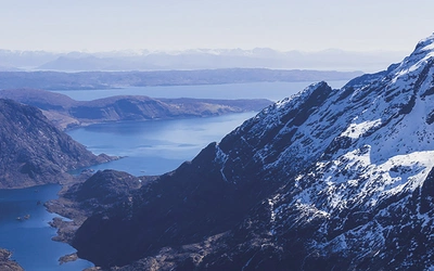
The Livingstone Croft Trail explores the lush woodlands, headlands and valleys of Ulva, circling the prominent upthrust known as A' Chrannag. Along the way, the route passes the ruin of a croft believed to have been occupied by relatives of David Livingstone, the Victorian explorer and missionary. The connection gives the walk a pleasing biographical thread, though the scenery needs no such embellishment: the path clings as long as possible to the coastline, drawing every last ounce of pleasure from Ulva's remarkably varied shoreline.
Ben More, Mull's highest peak, dominates the view across the sound for much of the route, providing a fine backdrop to what is otherwise a gentle and waymarked coastal amble. The Boathouse cafe at the ferry terminal provides refreshments at the start and end.
Best time to visit: Late spring through early autumn, when the ferry operates and the woodland is in full leaf. Check ferry times on the Isle of Ulva website. The views of Ben More are at their clearest on still days after rain has cleared.

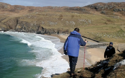
Camas Cùil an t-Saimh and Iona South
Summary: A dramatic walk to the rugged southern end of Iona, via golden sands and a hidden lochan
Start/finish: Iona ferry slip
Time: 2hr 30min
Distance: 8 km (5 miles)
Climb: 165m
Ferry required: Iona is reached by CalMac ferry from Fionnphort at the southwestern tip of Mull. Bus 496 connects Craignure and Fionnphort. A large, free car park is available at Fionnphort.
This circuit of Iona's southern end visits one of the most historically significant spots in Scottish Christianity. The walk passes close to the site where St Columba is believed to have landed on Iona in AD 563, having sailed from Ireland to establish the monastery that would become one of the great centres of early Christian learning in Europe.
The route crosses first to Camas Cùil an t-Saimh, a beach of golden sand backed by Atlantic machair, before heading south through increasingly rugged terrain to a lonely lochan. Beyond the lochan, the views across the sound towards Mull and the outer islands are a compelling reason to stop and take stock before completing the circuit back to the ferry slip.
Best time to visit: Late spring and summer for the best beach conditions and the full splendour of the coastal machair in flower. Iona is a popular destination and the walks feel quieter in spring and autumn outside the main visitor season.
15 Short Walks on the Isle of Mull
£9.95
Discover 15 of the best short walks on the Isle of Mull, including Ulva and Iona. Each walk comes with easy-to-read Ordnance Survey maps, clear route description and lots of images, plus information on beauty spots and refreshment stops. No challenging terrain or complicated navigation means walks can be enjoyed by everyone.
More informationYou'll find all these routes (and 10 more) in our guide to 15 Short Walks on the Isle of Mull, which contains clear route descriptions, OS mapping, plus facilities, parking and highlights for every route. Each route has been carefully selected to showcase the best of the area. No challenging terrain or complicated navigation means the walks can be enjoyed by everyone.
About Terry Marsh, author of this 15 Short Walks Isle of Mull:
Lancashire-born writer and photographer Dr Terry Marsh specialises in the outdoors and travel. He has been writing guidebooks since the mid-1980s and is the author or revision author/editor of over 100 titles, including the award-winning Cicerone guides to the Coast-to-Coast Path, The Shropshire Way and Great Mountain Days in the Pennines. Terry has a long-standing interest in the Scottish islands, Cumbria and the Lake District and the Yorkshire Dales. Academically, he is an historical geographer holding a Master of Arts degree with Distinction in Lake District Studies and a PhD in Historical Geography. He is a Life Member of the Outdoor Writers and Photographers Guild.