Walking on Rum and the Small Isles: a complete planning guide
Rùm, Eigg, Muck and Canna lie scattered off mainland Scotland's Atlantic coast, overlooked by the crowds drawn to the famously scenic grandeur of neighbouring Skye — and that, for the adventurous walker, is precisely the point. The Small Isles offer 25 routes from 4 to 41km across four distinct islands, from the towering volcanic Cuillin of Rùm to the flower-carpeted shores of diminutive Muck. Remote, wildlife-rich and largely free of vehicle traffic, this is an archipelago best experienced on foot. (Last updated: June 2026 · Guidebook edition: 2nd edition, September 2025)
Walking on Rum and the Small Isles, quick facts:
- Location: Inner Hebrides, Scotland
- Islands covered: Rùm, Eigg, Muck and Canna
- Total routes: 25 coastal and mountain walks
- Distance range: 4–41km (2–25 miles)
- Longest route: 41km (25-mile) 3-day circuit around Rùm
- Typical duration: Half-day to multi-day
- Difficulty: Moderate to challenging (easier walks available on Muck and Sanday)
- Terrain: Mountain paths, coastal cliffs, moorland, shell-sand beaches and machair
- Navigation: Step-by-step descriptions with 1:50,000 OS mapping; GPX files available; navigational proficiency essential
- Best season: May to early October
- Guidebook:Walking Rùm and the Small Isles by Katie Featherstone and Peter Edwards, 2nd edition
Walking Rum and the Small Isles
Rum, Eigg, Muck, Canna
£16.95
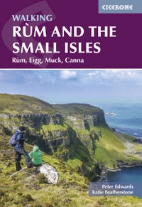
This guidebook to walking and backpacking on Rum, Eigg, Muck and Canna includes a circuit of the Rum Cuillin, an ascent of An Sgurr (Eigg) and a 3-day trek around the coast of Rum. The 25 routes across the four islands of the Small Isles archipelago of Scotland are suitable for a range of abilities exploring coasts, mountains and wilderness.
More informationWhat are the Small Isles?
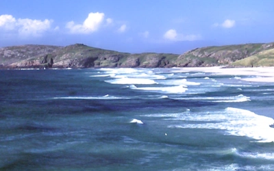
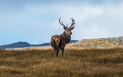
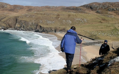
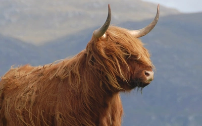
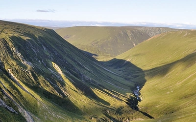
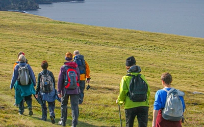
Walking on Rùm and the Small Isles means exploring four geologically distinct islands — Rùm, Eigg, Muck and Canna — that form a compact archipelago off Scotland's west coast, north of Ardnamurchan and south of Skye. Each island has an unmistakably individual character. Rùm is the largest and the most dramatic: its towering, volcanic Cuillin hills rise from magnificent glens and corries above a coastline that is by turns forbiddingly rugged and breathtakingly beautiful. Eigg is crowned by the remarkable pitchstone crest of An Sgùrr, standing sentinel over the island, while Canna's tiered volcanic rock rises to twin plateaux flanked by a rampart of awe-inspiring cliffs. The fertile, low-lying Isle of Muck is the smallest of the group, given over largely to a single family-run livestock farm — and, in fine weather, there are few Scottish islands as idyllic.
The Small Isles are often called the "hidden gems" of the Hebrides, and with good cause. They tend to be overlooked, literally and metaphorically, by the visitors drawn to Skye. The lack of a road bridge, the sparse ferry timetable, the near-total absence of vehicle traffic and the paucity of waymarked paths all conspire to keep visitor numbers low. For walkers who prefer it that way, the rewards are considerable. There is a real sense of space here, among hills and along rugged coastlines that remain unaffected by large-scale tourism. These islands are a haven for those who value peace, freedom and the particular pleasure of navigation by map and compass over terrain that has been shaped by geology, history and wildlife rather than by the walking industry.
Compared to the nearby Isle of Skye, the Small Isles are less visited and more demanding in terms of logistics, but they offer something Skye cannot easily provide: genuine remoteness within a short ferry crossing of the mainland. Walkers who know the Cuillins of Skye will find the Rùm Cuillin a worthy and less-crowded counterpart. This planning guide answers the most common questions walkers have before setting out. For complete route descriptions and 1:50,000 mapping, see the Cicerone Walking Rùm and the Small Isles guidebook.
How many routes are there, and how are they organised?
The guidebook covers 25 routes organised into four island sections. Rùm receives the most attention, with 11 routes ranging from half-day hill walks to a 3-day coastal circuit. Eigg contributes 8 routes, including the celebrated ascent of An Sgùrr. Canna and Sanday together offer 3 routes, and Muck provides 3 further walks. The range across the four islands reflects both the relative size of each island and the variety of terrain available.
Eight routes that illustrate the geographic and difficulty spread of the guidebook:
| Route | Island | Distance | Time |
|---|---|---|---|
| A round of the Rùm Cuillin | Rùm | 23.8km (14.8 miles) | 9–10hr |
| Around the coast of Rùm (3-day circuit) | Rùm | 41.6km (25.8 miles) | 3 days |
| Kinloch to Kilmory Bay | Rùm | 16km (9.9 miles) | 5–5hr 30min |
| An Sgùrr and Grulin | Eigg | 11.5km (7.1 miles) | 4–5hr |
| The Beinn Bhuidhe plateau from Galmisdale | Eigg | 17.5km (10.9 miles) | 7–8hr 30min |
| Camas Sgiotaig and the north-west coast | Eigg | 6km (3.7 miles) | 1hr 30min–2hr |
| Around Canna | Canna | 20km (12.4 miles) | 7–9hr |
| Around Muck | Muck | 14.8km (9.2 miles) | 4hr 30min–6hr |

Who is walking on the Small Isles suitable for?
The Small Isles suit experienced, self-reliant walkers who are comfortable navigating by map and compass on pathless terrain. There are few waymarks, signposts or formed paths of any kind across much of the archipelago, and the terrain is often demanding — boggy moorland, steep volcanic ridges, rough coastal ground and river crossings that can become dangerous after heavy rain. Only fit, properly equipped hillwalkers with reliable navigation skills should attempt a round of the Rùm Cuillin.
That said, not all 25 routes fall into the challenging category. The lower-lying islands of Muck and Sanday offer shorter, less technical walks where the gradients are gentle and the terrain is more forgiving. Families with older children and less experienced walkers will find these islands a more manageable introduction to the archipelago, while strong hill walkers will find the Rùm routes and the ascent of An Sgùrr fully absorbing days.
Dogs are welcome on the islands under appropriate land access conditions, but the challenging terrain, boggy ground, deer tick prevalence and ferry logistics make the Small Isles a demanding environment for them.
How difficult is walking on Rùm and the Small Isles?
Routes range from the challenging (the Rùm Cuillin traverse requires good navigation skills, physical fitness and experience of mountain terrain) to the relatively undemanding shorter walks on low-lying Muck and Sanday. The principal difficulty on all four islands is navigational: there are very few marked paths, and accurate route-finding is an indispensable skill rather than an optional extra. An OS Explorer 1:25,000 map (sheet 397), compass and GPS are all essential. An altimeter is strongly recommended for the hill routes on Rùm.
River crossings add further complexity in wet conditions. After heavy rain, burns and rivers on Rùm in particular can run at a terrific volume of fast-moving water, making crossing dangerous or impossible. Always check conditions before setting out and do not attempt to ford rivers in spate.
What is the best time to walk on the Small Isles?
May and June are generally the finest months: the weather is at its mildest, the days are long, and the summer ferry timetable is in operation. Early September is also excellent: the midges thin out, the light is beautiful and the islands are quieter than in high summer.
- Spring (April–June): The best combination of weather, daylight and ferry frequency. Midges begin to emerge from late May on Rùm and Eigg; less of a problem on the breezier, lower-lying Canna and Muck.
- Summer (July–August): Longest days and the widest range of island amenities open, but midges on Rùm and Eigg can be extremely aggressive, especially in still, humid conditions. Bothies and popular bays will see more visitors.
- Early autumn (September–October): A strong shoulder season. Midges diminish, the islands quieten, and the light takes on an autumnal quality that rewards photographers. Check ferry timetables carefully as summer services begin to reduce.
- Winter (November–March): Short days and a strong likelihood of wild weather. December and January are the wettest months, and boggy ground can make many routes extremely arduous. River crossings become hazardous. However, winter visitors may experience the islands in conditions of exceptional grandeur, with clear starlit nights and the possibility of aurora borealis. The winter ferry timetable is reduced to three or four crossings per week.
Note that midge season on Rùm and Eigg runs roughly from late spring to late autumn. Carrying serious insect repellent and a midge head net is strongly recommended from May onwards.

How do I get to the Small Isles?
The principal ferry service is operated by Caledonian MacBrayne (CalMac) from Mallaig. Foot passengers are advised to book in advance. Vehicle access is not generally permitted; visitors are usually expected to travel as foot passengers. Sailings visit multiple islands on a single crossing, which makes the timetable complex. Careful study in advance is essential. In summer, each island has five or six crossings per week; in winter this reduces to three or four. Journey times vary: a direct sailing to Rùm takes approximately 1hr 25min, while a sailing that calls at multiple islands can take over 4 hours. Ferries can be cancelled due to weather at any time, but this is more common between September and March.
An additional passenger ferry operates from Arisaig (Arisaig Marine) during summer, and AquaXplore runs a fast RIB service from Elgol on Skye. Visiting multiple islands in a single trip is worthwhile but requires careful advance planning around the timetable.
What accommodation is available on the Small Isles?
Accommodation options on the Small Isles are limited but generally excellent in quality. On Rùm, there are bothies in remote locations including Dibidil and Guirdil, a hostel at Kinloch and limited camping. Eigg has a campsite and self-catering options at Galmisdale. Canna and Muck offer small guesthouses and limited self-catering. The islands' amenities are far from extensive, and advance booking is strongly recommended for any visit. Bring adequate supplies, as provisioning on the islands requires forethought.
For full accommodation listings, consult the guidebook appendices.

How do I navigate on the Small Isles?
Navigation on the Small Isles is significantly more demanding than on most mainland walking routes. There are very few waymarks, signposts or formed paths. The OS Explorer 1:25,000 sheet 397 (Rùm, Eigg, Muck, Canna and Sanday) and the Harvey Maps 1:25,000 Superwalker XT25 are both recommended; the OS Landranger 1:50,000 sheet 39 covers the same area but with less topographic detail. A compass is indispensable; a GPS device and altimeter are both strongly recommended, especially for the hill routes on Rùm.
GPX files for all 25 routes are available to download free at www.cicerone.co.uk/1217/GPX. A GPS device is an excellent aid to navigation, but always carry a map and compass as a backup.
Do not rely solely on mobile phone coverage for navigation or in emergencies. Signal can be patchy or non-existent across much of the archipelago. Register your mobile for emergency SMS before you travel, and consider carrying a personal locator beacon (PLB) if walking alone or in remote areas.
Walking Rum and the Small Isles
Rum, Eigg, Muck, Canna
£16.95
This guidebook to walking and backpacking on Rum, Eigg, Muck and Canna includes a circuit of the Rum Cuillin, an ascent of An Sgurr (Eigg) and a 3-day trek around the coast of Rum. The 25 routes across the four islands of the Small Isles archipelago of Scotland are suitable for a range of abilities exploring coasts, mountains and wilderness.
More informationPlan your walking on the Small Isles with the Cicerone guidebook
The Cicerone Walking Rùm and the Small Isles guidebook (2nd edition, September 2025) by Katie Featherstone and Peter Edwards covers:
- 25 route descriptions across Rùm, Eigg, Muck, Canna and Sanday, from half-day coastal walks to a 3-day island circuit
- 1:50,000 OS mapping with highlighted routes for all 25 walks
- GPX file downloads for all routes
- Practical planning sections covering when to go, getting there by ferry, access rights, safety, navigation and what to take
- Individual island introductions covering geology, history, wildlife, transport and amenities for each island
- Appendix A: route summary table with distances, ascent and timings
- Appendix B: useful websites and further reading
Available as a printed guidebook (£16.95) or digital eBook (£16.95).
About Katie Featherstone and Peter Edwards, guidebook authors
Katie is a freelance writer focusing mainly on hiking, history and sustainable travel. She has published a guidebook to the Inner Hebrides, writes articles and walking routes for a number of magazines and newspapers, including The Guardian, Trail, TGO Magazine and The Independent, and is currently working on several walking guidebooks for Cicerone. Living in West Scotland, she enjoys walking and cycling whatever the weather, with Loch Lomond and the Trossachs as her nearest national park and somewhere she tries to spend as much time as possible.
Since moving to Scotland from the south of England in 2006, Peter has developed a passion for the Hebrides. He lives at Rhenigidale on the Isle of Harris with his wife, Fiona, and their Labradors, Dougal and Mara.