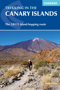
Trekking the GR131 across the Canary Islands

The island-hopping GR131 is an amazing trail offering the best possible route across all seven of the Canary Islands. It takes in some of the best scenery that each island offers as well as plenty of heritage.
The terrain of the GR131 is incredibly varied, taking in volcanic Lanzarote and desert-like Fuerteventura, followed by the first encounters with forested mountains on Gran Canaria. The traverse of Tenerife includes the spectacular Teide national park, and an ascent of El Teide brings the highest mountain on Spanish territory underfoot. Little La Gomera features the world’s best-preserved laurisilva ‘cloud forest’, protected as a national park. La Palma is reputed to be the steepest island in the world, while El Hierro was once believed to be at the very end of the world!
The GR131 has been pieced together stage by stage, one island after another. Standard European red and white markers were adopted for the trail and the signposting is largely consistent from one island to another. When winter weather puts a damper on the aspirations of most long-distance walkers, it’s good to know that the GR131 can be followed almost any time of the year.

Trekking in the Canary Islands
The GR131 island-hopping route
£18.95
Guidebook to the GR131, an island-hopping trail that runs coast to coast across each of the 7 Canary Islands, a sub-tropical Spanish archipelago. Described over 32 stages, the route begins on Lanzarote, finishes on El Hierro, measures 560km (348 miles) and would take an average trekker about 1 month to complete.
More informationWith most ‘mainland’ trails, trekkers can be quite relaxed about how they approach their day-to-day routines. On the GR131, there’s always a need for a couple of days of forward planning and timetable juggling. Some parts lack accommodation and those who don’t want to carry backpacking kit need to reach a bus stop and be assured of a bus if they plan to commute to and from the trail. When each island traverse is completed, it’s best to arrive at a ferry-port an hour before a ferry departs. There’s no point being five minutes late and discovering there isn’t another departure until the following day.
The GR131 is a very flexible trail. Those who wish to follow the entire trail in one go will take at least a month for the trekking, plus a couple of days to cover getting to and from the Canary Islands, as well as having odd spare days in case the ferry connections go awry. Alternatively, the islands could be traversed one at a time over a period of several years, in trips lasting from a few days to a couple of weeks.
Let’s take a look at the trail from east to west, island by island, and see what the highlights are along the trail.
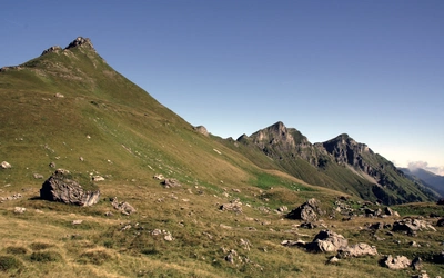
GR131 Lanzarote
Novice trekkers can enjoy the traverse of Lanzarote simply by basing themselves in Arrecife and commuting to and from the trail by bus each day. Just juggle the bus timetables and don’t worry about accommodation at the end of each day. The starting point is the coastal village of Órzola and the GR131 is marked by stout markers every 1km, so it’s simply a case of ticking them off while walking.
Quiet country roads and dirt roads pass farms and vineyards, leading trekkers from village to village, passing close to the highest point on the island at Peñas del Chache. Small towns such as Teguise, San Bartolomé and Yaiza are visited, which have interesting heritage features. In-between, steep-sided conical volcanoes are passed, and anyone looking to expend more effort is welcome to climb them. To finish efficiently, trekkers should aim to arrive in the resort of Playa Blanca in time to catch a ferry to Corralejo on Fuerteventura.
GR131 Fuerteventura
Before leaving Corralejo, note that the GR131 includes a short stretch on the little island of Lobos, but if you omit that, then simply walk through a range of volcanic hills to reach the little town of Corralejo. The interior of Fuerteventura looks bleak and arid, but it was once the breadbasket of the Canary Islands, where wheat was grown extensively. Once the central mountains are reached, you’ll find the hidden village of Betancuria, which is the former capital of the entire Canarian archipelago.
Unlike the traverse of Lanzarote, facilities are rather sparse on some parts of the GR131 through Fuerteventura. The mountain traverse in the middle of the island is splendid, but careful thought needs to be given to accommodation, and if leaving the trail, check public transport. The mountain landscape gives way to an extensive sandy desert at El Jable, then a series of resorts are passed, culminating in Morro Jable. Beyond the resort, the trail heads across a low, stony landscape to the distant lighthouse of Faro de Jandía. The trick is to reach a remote bus stop in time for a ‘monster truck’ bus ride back to Morro Jable and tie in with a ferry to Gran Canaria.
GR131 Gran Canaria
The important thing to realise about the route through Gran Canaria is that there isn’t one. Instead, I made up a coast-to-coast trekking route that won’t be too far off the mark once the trail finally gets established. It’s all signposted and waymarked, but not in the same style as on the other islands. Start in the southern resort of Maspalomas, where a path beside a riverbed makes a dead-straight beeline inland.
A mountain road, followed by mountain paths, introduces trekkers to the first extensive pine forests along the trail. After passing the mountain town of Tunte, a splendid high-level traverse is made across the mountainous crest of the island. If views are available, look out for prominent towers of rock, including the famous Roque Nublo. An unfortunate recent forest fire made a mess of the area around the mountain village of Artenara, but Canary pines are incredibly resilient and they will recover. After passing through extensive pine forests around remote Tamadaba, a descent leads to Puerto de las Nieves for a ferry to Tenerife.
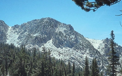
GR131 Tenerife
This is the largest of the Canary Islands, and it’s the only island where the GR131 doesn’t make a coast-to-coast traverse. Instead, trekkers need to start above 1000m in the little town of La Esperanza, as early as possible in the day, in order to cover a long and densely forested stage to reach La Caldera before the last bus leaves. Basically, there are no facilities of any sort for the whole of that first long day.
The forest cover eventually thins out on the fringes of the Teide national park. The park is entirely mountainous and is consistently over 2000m above sea level, with amazingly rugged volcanic scenery dominated by the 3718m El Teide. The mountain is the highest point on Spanish territory, and trekkers looking for a real challenge are encouraged to include it, otherwise the GR131 follows what turns out to be a remarkably easy track that passes places where it’s barely possible to walk at all!
The descent from the national park leads into extensive pine forest and passes through Vilaflor, which is Spain’s highest village. The GR131 finally reaches the little town of Arona, where it’s possible to catch a bus straight down to Los Cristianos and, with a bit of luck, connect immediately with a ferry to La Gomera.
GR131 La Gomera
The GR131 across La Gomera again features stout markers at 1km intervals, as well as a fairly relentless climb towards a huddle of awesome rock towers, dominated by the Roque Agando. Pine and laurisilva forests are encountered and the trail reaches the highest point on the island at Garajonay, overlooking a national park established to protect a wonderful ‘cloud forest’. The trees are capable of sieving droplets from passing clouds, dripping water onto the ground.
Mountain villages offer food and drink, before a splendid part of the ‘cloud forest’ is entered, followed by a long descent to the charming village of Vallehermoso. All that remains is a simple valley walk to a rugged beach at Playa de Vallehermoso. Well, there’s also the need to get a bus all the way round the island to make the best possible connection with an infrequent ferry to La Palma.
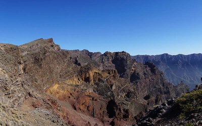
GR131 La Palma
This is reputed to be the steepest island on the planet. The GR131 is largely lacking in facilities; while there are buses serving the start and finish, none serve the middle of the route, where trekkers need to be self-sufficient. Starting at the twin lighthouses at Faro de Fuencaliente, the GR131 climbs bare, loose volcanic ash, passing a volcano that erupted as recently as 1971. Fuencaliente is the last village on the trail, so make the most of everything it offers.
The Ruta de los Volcanes is a high-level traverse passing a number of volcanoes that erupted in the past few hundred years. It is now an integral part of the route. After passing the Refugio El Pilar, there is an even higher and more remote traverse along the mountainous crest of the island, overlooking the awesome Caldeira de Taburiente national park. The highest point on La Palma, the Roque de los Muchachos, stands at 2426m, with astronomical observatories dotted around its slopes. A long, long descent eventually leads to the coast at Puerto de Tazacorte. Be prepared to put some thought into the most difficult transfer of all – from La Palma to El Hierro – which could cost a day or two if not done efficiently.
GR131 El Hierro
There are two starting points for the GR131, depending on whether trekkers arrive by ferry or on a flight. Both routes converge after a couple of hours at the main town of Valverde. From there, a long-established pilgrim trail called the Camino de la Virgen has been incorporated into the route. Simply follow it onwards and upwards, eventually passing close to the highest point on the island at Malpaso.
The crest of the island is sparsely forested and the slopes are often covered in loose volcanic ash, but the walking is essentially easy, even if facilities are absent. The long descent passes a remote chapel, the Ermita de los Reyes, then continues down arid, rocky slopes towards Orchilla. Centuries ago, this was regarded as the ‘Zero Meridian’ at the end of the world, until Columbus sailed past and discovered the Americas. Now it serves as the end of the GR131, so you could say that you have walked a trail to the end of the world!
Put your timetable juggling skills to the test by planning your way back home.
Information
Maps The best maps of the Canary Islands are published by Editorial Alpina. At the moment they cover La Palma, La Gomera and Tenerife, with Gran Canaria to follow; all at a scale of 1:25,000. Some navigation apps offer access to Spanish IGN maps of varying scales covering all the islands.
Accommodation Check the usual accommodation websites, www.airbnb.com, www.booking.com, for a range of options, locations and prices. They’ve never failed me with short-notice bookings. Wild camping is illegal, but people do it anyway.
Public Transport Every island has its own bus service and most parts of the GR131 can be joined and left by bus at various points. Some parts can’t, so be aware of that. Ferries between the islands are operated by two companies – Fred Olsen and Naviera Armas. Flights between all islands are operated by Binter, although some islands are also served by Canaryfly.
GuidebookTrekking in the Canary Islands, by Paddy Dillon, published by Cicerone.