Thru-hiking the Continental Divide Trail: 1500 miles completed, many more to go
Owen Eigenbrot has reached around the halfway stage of his thru-hike from Canada to Mexico on the Continental Divide Trail. With each new trail segment, he realises that the journey is more important than the end goal and that the greatest challenges come in unexpected places.
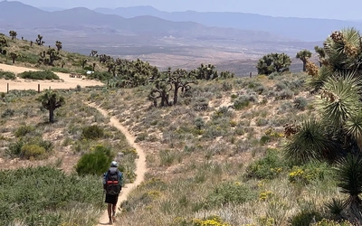
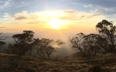
The first signs of fall are creeping into the mountains. Aspen leaves are beginning their transition from green to yellow, the wildflowers have long since bloomed and now sit dry atop brown stems, and frost adds a crunch to my steps on more mornings than not. Over the past three months, I have crossed spring snowfields, lain in blooming meadows of multicoloured flowers and sweated under an intense summer sun. Now I sit in Grand Lake, CO, just about to enter the highest, coldest and maybe most spectacular portion of the Continental Divide Trail (CDT), hoping that the good weather will hold for a month longer. The hike has gone according to plan for the most part. Now it is just a matter of hiking the miles and enjoying the experience.
So far, the CDT has taken me from the US–Canada border at Glacier National Park, through northern Montana, on a rollercoaster ride, flip-flopping the Divide along the Montana–Idaho border, through the mountains and desert of Wyoming, and now into the high Rocky Mountains in Colorado. The journey so far totals just over 1500 miles in 85 days. I’ve just picked up my third pair of shoes.
With the finishing mileage unknown and still very far away, I can’t know where exactly I reached the halfway point, but it is somewhere behind, in both miles and days. And now, as the season changes, I feel the accumulated miles, blisters, stubbed toes, early starts, late nights, spectacular vistas and kindness of strangers culminating to a climax that I am almost too nervous to think about. Will the weather hold so that I can get through Colorado before winter snow closes the trail? This is the question that I lost sleep over in March. It has been on my mind every day since. I have pushed myself hard to tip the odds in my favour and soon I will know the answer.
Highlights
In 1500 miles, I have seen many things that I would consider highlights. There are the obvious candidates, such as the soaring fins of rock in Glacier National Park, the geothermal wonders of Yellowstone, pristine alpine lakes and the views of many famous sub-ranges of the Rocky Mountains, notably the Teton and Wind River ranges. However, I have been consistently surprised by the places in between. The places that don’t see millions of visitors every year. In fact, most of the trail so far has been through the less-famous parts of the Rockies. Places that I had never heard of before setting foot on their trails. The Scapegoat Wilderness, the Anaconda-Pintler range, miles of exposed ridge along the Montana–Idaho border, the layered cliffs of the Teton Wilderness and the brutal heat of the southern Wyoming Basin. These are the glue that hold together a thru-hike, that link the famous portions together into something larger than the sum of its parts. Each has been a highlight in one form or another. Some for the raw beauty, and others for providing memories that will last a lifetime.
That being said, the Wind River Range in central Wyoming is a special place that exceeds expectations and defies description. As a California native, I harbour a great love for the Sierra Nevada Mountains. I hold every other range that I encounter under the harsh scrutiny of my unfairly biased criteria that was formed during my time exploring there. The Alps? Eh, too many glaciers, too many huts and too many thunderstorms. The Nepal Himalaya? The air is too thin and the mountains are too big to climb. You get the idea. So it is with great reluctance that I admit that the Winds pass the test. Combined are my favourite corners of the Sierra, amplified. Soaring granite faces, sharp ridgelines, glacial basins holding sapphire lakes, twisted high country. Add in a few more glaciers and abundant huckleberries and raspberries, and I have fallen in love. The Winds are it.
Besides the scenery, the trail has provided richly in the human department. I have made some wonderful friends, attended a trail wedding, had my eyes opened to different ways of life than I am used to, had to question my opinions because of it, and have been blown away by the generosity and kindness of complete strangers. The trail unites us. My fellow thru-hikers, the communities it passes through and the people that surround it, knowing or unknowing.
Lowlights
I hate to call anything a lowlight because everything, even the rough parts, contribute to the greater journey. The contrast between the lows and the highs make the best parts that much better. So maybe I won’t call this a lowlight. Perhaps greatest struggle is more fitting. Regardless, the desert of Southern Wyoming, or The Basin, has been the most challenging portion of trail so far. The Continental Divide splits here, forming a circle around a vast desert where water, what little there is, becomes trapped, not flowing to any ocean. I was excited to reach this stretch of trail, with a relatively flat elevation profile and no-nonsense straight-line dirt roads. I was expecting to fly from horizon to horizon, achieving personal daily mileage records and a deepening my already ridiculous hiker-tan.
The reality was different. The trail was not as flat as I anticipated, and I trudged instead of flying, day after day, sometimes without turning for 20 miles or more. Heat was mercifully not an issue every day, but lack of shade and distant water sources towards the end left the small group I was hiking with in bad shape. Temperatures of 34°C, combined with 40 miles of desert with nary a sage bush taller than my knees and 33 miles between water sources not contaminated beyond hope with cow poop, left us badly dehydrated before a passing truck gave us a case of water bottles. The hot ground and general filthiness that comes with water rationing, left the skin on my feet in a bad state that took a week to recover. Rather than finishing Wyoming strong, I limped across the border, with tape on my feet and the bad taste of cow water in my mouth.
Feeling fit
I think it is safe to say that I have ‘broken in’. I have worked through a number of minor issues in my feet, legs and shoulders since my start in June, but have dodged any significant injury that threatens my hike thus far. From my experience on the Pacific Crest Trail, I expected that my feet would be the source of the majority of issues for the first month or so. I have encountered a consistent dribble of minor blisters for most of this hike, but fortunately have missed the intense, step-altering pain of many blisters in combination. Sock changes and foot hygiene have not been as consistent as I would like but, so far, I have got away with it.
Lack of consistent stretching and self-care means that my muscles ache daily in the morning. If I had more discipline, I would carve out 15 minutes every day for this worthy practice, but each night the only thing I have energy for is inflating my sleeping pad, eating dinner, then falling asleep. The aches are here to stay. I like to think of them as a reminder of all the miles I’ve hiked and the wonderful things I’ve seen.
The changes to my physiology have been subtle and slow to manifest, but it is undeniable that my fitness level has increased dramatically. On day 1, the 13-mile hike to camp was a grind under a heavy pack filled with eight days of food. These days, daylight is the limiting factor on mileage. On a day uninterrupted by a town stop, 25 miles is the leisurely minimum, with 30 miles achievable at a push. With the days growing shorter and the challenging Colorado terrain, I might struggle to keep this standard, but the actual hiking is no longer the hardest part of this adventure. No matter how many miles are left or how much elevation there is to gain, I feel confident that my body will take me there.
What’s next?
The majority of the miles are behind me, but the most important, from a completion standpoint, are still to come. The next 600 or so miles will affect the overarching narrative of this hike in a profound way. Will the snow hold off until I am through the San Juans in Southern Colorado or will I be forced to reroute to lower elevations? Plan A is to stay high, along the continental divide to New Mexico where the snow pressure eases. The trail, for long stretches, will not dip below 12,000ft. The high point of the CDT, Grays Peak, stands at 14,278ft and is still a week’s worth of hiking to the South. The forecast is clear as far into the future as it dares to predict, but the locals are quick to remind that winter can strike at any time. The time pressure that has been with me since the beginning will continue to push me until I reach Cumbres Pass, located at the tail of the high mountains.
From there, it will be a cold, but hopefully dry hike through New Mexico to the Crazy Cook Monument at the US–Mexico border. The days will be short, requiring hiking by headlamp in the morning and evening, but the terrain should be quite flat. I was wrong about that once already, but I can’t be wrong about this too, right? Classic desert hiking awaits, as do the riparian gem of the Gila Wilderness and its numerous hot springs in which to soak my tired bones. I am looking forward to the spicy green chili cuisine as well. New Mexico will be incredible and, without much time pressure, a soothing mental balm for my over-anxious mind.
Concerns
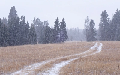
I bet you can guess by now what weighs on my mind most heavily. Yep, it’s the coming winter and the snow it will bring. I had a taste of it about one week ago as I crossed the Wyoming–Colorado border. It rained for most of the day. The temperature hung around 2°C. Although it was only 2pm, my partner and I set up our tent at the border for some respite from the cold. The rain passed, but the cold remained, and we woke the next morning to a dusting of snow. It melted quickly, but the message was clear. Keep moving! Later that day, the trail brought us to 11,000ft where the snow had stuck. Camping under the full moon on a clear night, the mercury dipped to -7°C. Hiking above 12,000ft the next day, we kicked through 10 inches of snow for 4 miles before dropping back to dryer elevations. A warm front has moved in, melting what remained, but I won’t forget the cold. I won’t forget how quickly things can change in an alpine environment.
Although it can feel like I’ve been hiking the CDT for an eternity, the truth is that there are a lot of miles left. A lot can happen between Grand Lake and the Mexican border. A twisted ankle, a bout of giardia, or a stolen backpack are all possibilities and potentially fatal to an attempted thru-hike. Yeah, the coming winter is on my mind, but if my hike ends shy of the border, odds are good that it is because of something I didn’t see coming. And you know what? If that happens, I will still return home satisfied. To think that the validity and value of the miles that I have already hiked, the sights I’ve seen, the sunsets I’ve witnessed and the friends I’ve made rely solely on my successful completion of the CDT is bogus. That would be missing the point. No, the journey so far has been spectacular, everything I could have hoped for and more. Worth it, regardless of what the next two months will bring. One of the great benefits of a hike this long is that it forces one to focus on the journey, not the end goal, which can be too big and too far away to comprehend. I am grateful for each and every day I am able to be out here. I have hiked far and have far to go, but before long, the CDT will seem too short.
I’ve tried to be brief in describing the first half of my experience on the CDT and it has not been easy. This trail has so much to offer. If you are interested in reading a lot more and would like to follow the journey in more detail, head over to my blog at hikefordays.com, which I am updating with daily posts. It also includes some shorter Cicerone-inspired trip write-ups from the Alps if following along for the five months seems like a daunting task. Additionally, my partner and I are using this hike to raise funds for Big City Mountaineers who take under-resourced youth on mentorship-based wilderness backpacking excursions. We are passionate about this cause and would appreciate any support tremendously. For more information on BCM, head to our fundraising page: give.classy.org/cdt
Read Owen's first article: Thru-hiking the Continental Divide Trail: Prep and planning