Hiking the Great Glen Way: a perfect introduction to long-distance walking in the UK
Jonathan Cook hikes his first long-distance National Trail, The Great Glen Way, which runs from coast to coast in the Scottish Highlands. Along the way he samples some of the most spectacular scenery Scotland has to offer, delves into its turbulent past and hopes to catch a glimpse of the famously elusive Loch Ness Monster.
Despite my love of the Lake District and having hiked extensively in Europe as well as exploring parts of remote Alaska, I had rather embarrassingly never walked one of the many excellent long-distance footpaths in the UK. At the beginning of 2018 I decided to change that and after doing some research opted for the interesting looking and accessible Great Glen Way in the Scottish Highlands.
What I particularly liked was the idea of making a complete traverse from one side of Scotland to the other by foot.
The Great Glen Way is a 79-mile National Trail following the entire length of Scotland’s longest glen along an ancient geographical fault line. Running southwest to northeast across the width of northern Scotland, the trail links the bustling outdoor centre of Fort William with the regional capital of Inverness.
Despite this giant natural corridor existing for millions of years and the plethora of man-made attractions that brought a network of roads, railways lines and the Caledonian Canal, there was no formally way-marked route until 2002 when it was officially opened as a National Trail and added to the list of Scotland’s Great Trails. In 2014, a high-level option was added between Fort Augustus and Drumnadrochit, and there are now bike and canoe alternatives.
Dubbed as an ideal introduction to long-distance walking, the route can be easily walked between five and seven days. With a major train station at the start and end of the route, an airport in Inverness and a regular bus service running along its entire length, the walk is very accessible and allows walkers to break up the route into shorter or longer sections as required. There are also a number of luggage transfer services and ample accommodation options along the route.
I decided to base myself in Fort Augustus, which is at the midpoint along the route. My aim was to walk its entirety in four stages, making it slightly more challenging, and retire to the comfort of Fort Augustus Abbey on the shores of Loch Ness after each stage.
I travelled up by car from southern England, with an overnight stop in Carlisle to break up the long trip. The following day we took the scenic A82, which runs all the way to Fort William through some of Scotland’s most spectacular scenery and offers one of the finest road trips the UK has to offer.
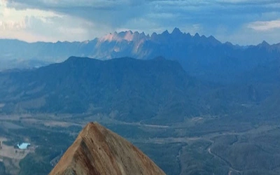
We took advantage of the many picturesque stopping points along the route, starting with the small village of Luss on the banks of Loch Lomond. From the small pebble beach, we enjoyed great views of Ben Lomond, the southern-most Munro. The beautiful and impressive Falls of Falloch are just north of the loch and are surrounded by quiet woodland. Our journey then took us through Rannoch Moor, one of the last remaining wildernesses in Europe, a vast boggy moorland beneath towering peaks and home to the iconic Buachaille Etive Mor, one of the best-known Munros. Finally, we passed through the spectacular steep slopes of the Glen Coe valley, before arriving in a sun-bathed Fort William.
The undisputed capital of the Highlands, Fort William stands in the shadow of Ben Nevis, Britain's highest mountain, and is a bustling town strung out on the shores of Loch Linnhe.
It provides a natural stopping place for those heading further north, as well as the last opportunity to stock up on supplies before starting the Great Glen Way. We had made good time so took advantage of the good weather and made the short evening stroll up Cow Hill, a pimple sitting alongside Ben Nevis. It offers a grandstand view of the surrounding area and gave me my first glimpse of the Great Glen to the north where it was possible to pick out the Caledonian Canal and River Lochy winding towards Loch Lochy and the path I would be following tomorrow.
Stage 1: Fort Willam to Laggan Locks – 36km
All routes have to start somewhere and it was on an overcast Monday morning in early May that I crossed through the Morrisons supermarket carpark to a large stone monument that marks the official starting point of the Great Glen Way. I passed a McDonald’s restaurant as the route then led away on tarmac pathways from the noisy centre of Fort William along the shores of Loch Linnhe, through a housing estate and past a tired-looking shinty pitch. I was thankful for the distinctive blue thistle logo signs guiding me at every turn and which turned out to provide excellent signage throughout the entirety of the route.
After crossing over the interestingly named Soldier's Bridge, built by the Royal Engineers, I got a quick view of Inverlochy Castle and my first glimpse of the mighty River Lochy, which would now be a continuous presence until Gairlochy where its source begins. I climbed down from the bridge and up a steepish embankment on to the Caledonian Canal towpath where the route turns right and leads away into the Glen. I decided to turn left and investigate the sea loch at Corpach and look at the striking pepper pot lighthouse that marks the start of the canal.
Of course, the real reason I took the detour was to be able to boast that I had walked sea to sea.
After retracing my steps, I strode forward on the flat gravel towpath towards Gairlochy, savouring the views back to Fort Willam and the snow-capped Ben Nevis.
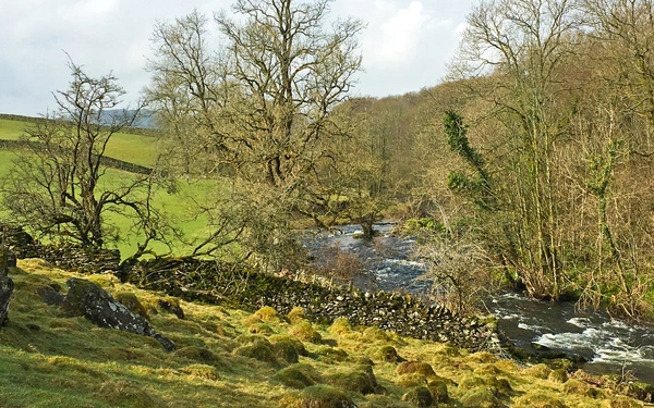
Despite being nearly 200 years old, the Caledonian Canal is still one of Britain's greatest engineering feats. Built by Thomas Telford between 1803 and 1822, it is still the first waterway connecting the North Sea with the Atlantic and offers vessels a safer and quicker route from one side of Britain to the other, avoiding a trip around the top of Scotland. Consisting of 29 lochs and 10 bridges it tested Telford’s skills to the full and involved diverting the flow of all the main rivers along the route as well as altering the levels of Loch Oich and Loch Ness.
As I approached the most complex of the 29 lochs, aptly named Neptune’s Staircase, I was lucky enough to see The Jacobite, a steam locomotive train service that operates between Fort William and Mallaig over part of the West Highland Railway Line, fly past. I could have marvelled all day at the boats climbing the steep slope of eight lochs before I continued along the surprisingly peaceful curving towpath, flanked by an abundance of trees to Moy swing bridge before arriving at Gairlochy where I enjoyed a spot of lunch on one of the picnic tables sandwiched between the River Lochy and the canal.
Leaving Gairlochy via another swing bridge it began to rain as I entered forest, climbing a slope before descending and joining a path hugging the northern shore of Loch Lochy, home to Lizzie, the lesser known cousin of Nessie, who failed to materialise on this wet afternoon. After drifting away from the shore and following a short section of road past Achnacarry, home to the infamous Clan Cameron and later a commando training centre, the spectacular memorial at Spean Bridge pays homage to the Commandos who trained in the area and is well worth a visit if time permits. After leaving the small cluster of houses at Clunes I followed the quiet, long forested loch side track all the way to Laggan Locks where, after nine hours of great walking, I was looking forward to a well-earned rest.
Stage 2: Laggan Locks to Invermoriston – 29km
I returned early to Laggan Locks the following morning and began stage two, which would take me to Invermoriston and just over half way of the route. The first 17km to Fort Augustus were really enjoyable, starting with a gentle stroll along the canal before entering woodland. In no time I'd arrived to Laggan swing bridge and crossed the busy A82 before passing the Great Glen Water Park with its fantastic-looking holiday homes. Continuing around the southern shore of Loch Oich, the smallest and arguably most picturesque of the Great Glen lochs, I joined the old Invergarry and Fort Augustus Railway trackbed, where a restoration project is underway to restore and preserve the old platform at Invergarry. I enjoyed this flatter, quieter section passing through a number of old railway tunnels with the fine views back down Loch Oich and the surrounding hills.
After crossing the A82 again and admiring the old bridge of Oich at Aberchalder, the next 8km stretch took me up to Fort Augustus and was my favourite part of the canal. The canal meanders and is wide in parts, giving the appearance of a natural river, while the River Oich is a constant presence on the left, I was actually walking on a narrow causeway sandwiched between the river and the canal. Again, I marvelled at the ingenuity of Thomas Telford as I crossed a large overspill weir feeding excess water from the canal into the river.
At Loch Kytra I spoke to a friendly canal worker as she opened the lock to let boats through, who told me around 53,000 boats pass through the locks each year.
The steep flight of five locks brought me into the busy tourist town of Fort Augustus. A little-known fact is that this is home to where the Ordnance Survey map was born as a way to help English soldiers track down Scots who had no reliable maps of the area at the time. It also has a Caledonian Canal visitor centre, which has some very interesting information about how the canal was built and the challenges that Thomas Telford faced.
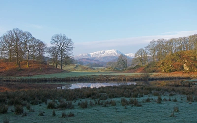
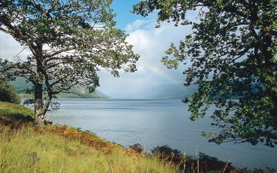
Despite the temptation to stop at the Monster Fish and Chip restaurant, I resisted and pushed on towards Invermoriston. I opted for the high route that rises up to 330m and includes a couple of steep ascents through thick forest, which at times was quite eerie. But once up the views down the whole of Loch Ness and across to the Monadhliath mountains on the opposite side of the loch were well worth it. The high option really transforms this part of the route, with interesting sculptures and stone seats around nearly every corner. Today's route concluded with a steep descent arriving to Invermoriston's Thomas Telford bridge, crossing the spectacular River Moriston falls.
Stage 3: Invermoriston to Drumnadrochit – 22.5km
Today turned out to be my favourite stage of the whole route. Opting again for the high alternative, the route climbed over the highest point of the entire Great Glen Way on the slopes of Creag Dherag at 470m and offered breathtaking views of Loch Ness and the surrounding area.
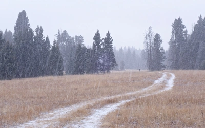
Beginning the day by zig-zagging through the dense forest surrounding Invermoriston, the forest track opened into to a felled area, home to The Viewcatcher, a large circular stone sculpture made from local stone and Caledonian pine that forms an eye in the sky to highlight the stunning view. They say on a clear day you can see all the way to Ben Nevis and beyond, but I was experiencing a rather typical Scottish day with bouts of hail, rail, strong winds and, of course, sunshine, which really highlighted the ruggedness of the terrain. I was grateful to have my woolly hat and gloves with me as I sheltered in a wind shelter near the highest point eating my sandwiches. I then left the larger forest tracks and wandered along a pleasant gravel path, which undulated through a variety of trees before crossing the rustic troll bridge decorated with troll themed poems and limericks from local schools.
After rejoining the lower route and leaving the barren heathland behind, a quiet road section took me past isolated farms and cottages, then across boggy moorland to Clunebeg before descending gentle slopes to the river Coiltie near the village of Lewiston and finally a short section along the A82 to the village of Drumnadrochit. It has several nice cafés, a tourist information centre and ample accommodation options.
Stage 4: Drumnadrochit to Inverness to – 30.5km
Unfortunately, the closest I came to seeing the Loch Noss Monster was in Nessieland – a themed exhibition – and the Loch Ness Monster Exhibition centre, which are both located at Drumnadrochit and where you are invited to examine all the evidence for yourself.
I must admit I like the idea of thinking something might exist in the depths of this enormous mass of water.
Despite being on the home straight, another long day started with an unpleasant stretch along the busy A82 – albeit fairly short. It was a welcome relief to climb away from the road on a quiet single track where I got views of Urquhart Castle, which sits of the shores of Loch Ness and is well worth a visit, being one of the largest medieval castles in Scotland. I was then once again engulfed by dark forest but this time I was a little bit cautious as I had been warned about the possibility of encountering an Urquhart puma by a local café worker that morning. I'm not sure if they really exist but I was grateful not to come across one.
As I climbed through the forest I got several more views of Loch Ness as I began to drift away from the loch. I was starting to feel quite tired as I meandered across forest tracks high above Abriachan, which is a large community owned forest with a number of attractions. I passed Loch Laide before following a small narrow gravel path, which was littered with endless signs reading Hot chocolate, Real coffee or Lemon cake, which only seemed to fuel my tiredness before I finally reached an eco-campsite with a small café hidden away in the woods.
Despite now joining a road section, I was crossing some of the wildest terrain on the route as the sun came out and I looked at the views of the imposing snow-capped hills for one last time before starting to converge on Inverness. I began winding down hills through fields and got my first views of Inverness before passing through grassy spaces interspersed by houses, before the path took me on to the pretty Ness Islands and gardens that are connected by several bridges crossing the vast and powerful River Ness – a reminder of just how much water flows out of Loch Ness.
My journey came to an end as I followed a popular path called Ladies Walk along the river before I climbed up the short Castle Hill where Inverness Castle stands aloft and provides a fitting end to the route against the backdrop of the River Ness.
The Great Glen Way can be walked all year round and although I walked it in May, avoiding busier summer months and to avoid the notorious midges, the weather threw up just about everything. I really enjoyed the diversity of the route and was surprised at how few people I encountered while walking. From the peaceful canal towpath to quiet forest tracks and deserted sections of abandoned railway and minor roads – for me, it offered a perfect introduction to walking in the Highlands of Scotland while never being far from local amenities. I will definitely be back!