The Australian Alpine Walking Track
The Australian Alpine Walking Track is almost unheard of, even in Australia. At 650km, it provided a mentally and physically demanding test for Emma Timmis.
The remote Australian Alpine Walking Track (AAWT) is not to be taken lightly. Stretching 650km from Walhalla in the state in Victoria to Tharwa in the Australian Capital Territory, this rugged and sometimes non-existent trail is designed to test you. In March 2016, I set out for a solo, month-long adventure in the Aussie mountains (yes, there are mountains out there!).
When I thought about doing a long trek in Australia, scenes from Home and Away played in my mind. I envisaged cruising along the trail, stopping regularly to top up my tan as I basked in a cool breeze. You’ll see how far from reality my expectations were.
If you haven’t heard of the AAWT, you aren’t alone. Most Australians I spoke to didn’t know of its existence – perhaps because of its remoteness or because Australia is more well known for golden beaches, not Alpine peaks.
Most people allow themselves six or seven weeks to complete the trail comfortably. It doesn’t pass through any towns or villages and there are no opportunities to purchase supplies unless you hitchhike or walk some distance off track. For this reason, I did what most walkers do and drove out in advance to bury food in sealed containers along the way, praying that I could locate them again and that they would not have been pinched by other hungry hikers or wild animals.
The trail is marked by yellow triangles, which are often missing, hidden deep in vegetation or half-eaten by the growing tree trunks they were attached to decades ago. Navigation skills are necessary. Even if there were more signs, there are huge areas that are massively overgrown or just forest with no visible trail. For these sections you need to be confident navigating. On a few occasions you’ll come across a sign explaining that the trail is non-existent and that you need to walk on a bearing. The sign kindly gives you the bearing to follow.
Preparation is the key to success on this trek. Along with burying my food and fuel for my stove, I also stashed my maps as I took nine in total. I also had the obligatory guidebook, Australian Alps Walking Track by John and Monica Chapman and John Siseman. The book is fantastic and gives information regarding food drops and planning. However, my version was last updated in 2009 and I don’t know if it has been updated since. I also found a very useful forum online from which I grabbed all the relevant information before heading out. Having never used a GPS device, one wasn’t part of my kit.
The trail has three quite different sections. The first is undulating and jungle like, the second is more exposed and almost always at a higher altitude, and the third is flatter with wider tracks. This is if you choose to go south to north. I guessed each section would take me about 10 days. I began with 10 days’ worth of food and fuel in my pack, and I left two food drops for 10 days each, one at Mt Hotham and the other at Dead Horse Gap.
After a fun two-day road trip burying food parcels in the wilderness, I began my walk from the southern end of the trail at the tiny gold-mining village of Walhalla. So tiny its population is 20! Starting early from the town rotunda, I heaved my 27kg pack on to my unconditioned shoulders and wondered what on earth I’d got myself into!
From the outset it was steep and overgrown terrain with ridiculously tall trees fallen across the slippery, thin path. Added to this were countless spiderwebs crossing the trail at the perfect height to smother my face, while parties of leeches crawled up my legs.
The humidity and moisture were stifling. I hadn’t been walking for an hour before I had to stop and frantically use the last glimpse of phone signal to google which of the face dwelling spiders could kill me!
Even with all the research I had done into this track, I didn't anticipate the terrain being so tough.
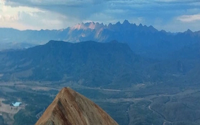
For the next few days I saw pretty much nothing as the cloud was so thick. I was constantly hiking up and down mountains. The book assured me that the views were spectacular, but I couldn’t tell you from experience as all I saw was thick, grey mist. It wasn't until day five that the mist cleared briefly at the top of a mountain, treating me to a beautiful view. For miles and miles I could see forest-covered mountains like a plump, green, furry quilt. I had climbed many mountains by this point but on each summit I was rewarded with nothing but clouds. And even after getting this beautiful, yet brief, view I then dived back into the clouds for the next five days.
These cloudy days were spent weaving through dense forest, rarely seeing the sky and soaked in moisture and sweat. The track had so few markers that you had to keep your wits about you.
So many huge trees had fallen over and across the trails that carrying the pack on my back wasn’t the only challenge; mounting logs or crawling under them also became part of the game. I wondered if I’d found myself in some form of commando training.
Every now and then I would pop out of the forest and clamber upon some thought-provokingly named peaks. There was Mt Speculation, Mt Despair and The Viking, to name a few.
The section of trail between Mt Howitt and Mt Buggery is named the Crosscut Saw and enticed me in from the day I got my hands on the guidebook. It is described as a ‘ragged, narrow, razorback ridge’. Unfortunately, this was another delight I missed out on as the fog was so thick I could barely see my hand in front of my face. As I followed the thin track I could have been anywhere in the world.
I successfully found my hidden food parcel at Mt Hotham and I sat in the road filling my face with the tinned fruit salad that I’d stashed as a treat. This is where the second section began and from here it started to get very cold at night. I was at a much higher altitude most of the time, and much more exposed as the forest thinned out. Every night I would wake at about 2am and lay shivering in my sleeping bag, wearing everything I had, trying unsuccessfully to get a little more sleep before the 5:45 alarm. Each morning I stepped out of my tent to find frost covering my home. My daily routine was based on packing up wet things and hoping the afternoon would be warm enough to dry out all of my heavy, soaked kit.
The sun warmed my face during the day and scents of eucalyptus drifted past in the fresh air. The terrain now was quite smooth and less steep. This was until I got to Big River. In the space of a few kilometres I descended approximately 900m in altitude, following the trail down to the river only to cross it and head straight back up. On the downward side there was a manmade zigzag track to ease you down but this didn’t continue on the other side of the river. The track was so steep on the way up that I feared if I sneezed I would be pulled off the hillside by my enormous pack, plummet hundreds of metres and be sent swimming.
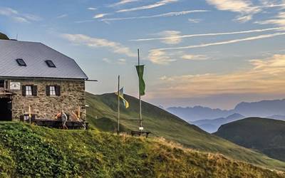
Paths became clearer and as there were fewer trees you could see a marker in the distance and let your mind wander as you moved in the right direction. As I made my way further north there were also more huts. If you planned your time well you could probably spend half your nights in a hut with a warm fire. When the opportunity came I wanted to sleep in the huts but I often found it warmer to be in my tent. On one occasion I did try my tent inside a hut; I’m not sure this added any extra warmth. The huts are all very basic and rustic, and I’m not sure if they are maintained by anyone but they beautifully charming and definitely worth a visit.
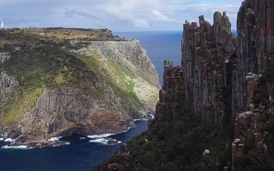
My second food drop was found and collected at Dead Horse Gap. One of the highlights of this trail is that it takes in Australia’s highest point, Mount Kosciosko. Standing at 2228m, it is nearly a kilometre higher than any UK mountain. You get no sense you are at this height, though, as you stroll onto the summit with no steep edges or rocky scrambles. But what you do get is spectacular 360-degree views, reaching out for eternity.
My stay at the summit was brief as the wind was so extreme it was ripping the clothes off my body and the air out of my lungs.
The third section was the home straight. The majority of the terrain consisted of developed walking tracks or four-wheel-drive tracks. Overall, the altitude was heading steadily downwards, although quite a few hills seemed to sneak up on me. The distance I was managing to cover each day increased up to 35km. The real treat were the animals I was beginning to see (fewer snakes and spiders). As a strolled along I would often sense a head pop up from behind a bush. As I turned to investigate I’d make eye contact with a kangaroo and then see it bound off into the distance. The closer I got to the end of the trail the friendlier they got and would often be within a few metres of me and not move as I approached. I didn’t manage to see a live possum but there was one stuck in the chimney of a hut I stayed in. With the help of a couple of people also staying there, we managed to free it and it scampered off before I caught sight of it.
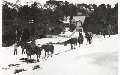
On one particularly cold morning, I woke and packed away my frozen tent. As the icy ground began to defrost and the mist rose, in the distance were a group of brumbies (wild horses) directly at the bottom of what I can only imagine is called a mist bow. Magical sights like this made all those early mornings worthwhile.
I left myself with only a short distance to cover on the final day. Walking alone across the plains I could see the final hill in the distance. As I weaved my way up a rustic walkway I could hear voices. At the peak of the hill I was met by people of all ages on their weekend family adventures. My peace and tranquillity were now over. Walking down to the Namadgi visitor centre felt quite overwhelming. After seeing no more than a few dozen people while on the trail, I was now surrounded by everyone getting away from Canberra for the weekend. I was welcomed in to the visitor centre that marks the end of the trail and presented with a certificate. You also get a choice of hot drink or ice cream as a little congratulatory gesture. After 24 days of living like a wild animal and carrying everything I needed on my back, I was quite happy to be back in civilisation. The AAWT gave me an amazing experience like no other trek. I saw a side of Australia that I never expected and would definitely recommend hiking at least some of this trail.
For those who want to take longer and explore more of this remote area of Australia, there are many additional sidewalks that can be added to the trail. Information on these can be found in the guidebook.