An intro to… The Japan Alps
The Japan Alps are a located in the centre of Japan’s main island of Honshu and are home to some of the country’s most famous, highest and rugged peaks. Tom Fay, author of Hiking and Trekking in the Japan Alps and Mount Fuji, introduces this wonderful region, which is perfect for walkers and trekkers.
Where and what are the Japan Alps?
Japan is a famously mountainous country. In the centre of the main island of Honshu lies a series of towering mountain ranges that are collectively known as the Japan or Japanese Alps. The name was first coined in the late 19th century by an English archaeologist called William Gowland, and later popularised by the English missionary and writer Walter Weston.
The Japanese Alps are comprised of three main ranges: the North, Central and South Alps, all three of which are home to mountains in the 2500m to 3000m range, with 20 peaks rising to over 3000m in height. The only other 3000m-plus mountain in Japan, Mt Fuji, lies alone further to the east and is Japan’s tallest peak, at 3776m.
The North (Kita) Alps are a roughly Y-shaped band of rugged mountains stretching inland for 100km from the Sea of Japan coast. Mostly volcanic in nature, there are a number of active volcanos throughout the range, and plenty of hot springs thanks to all the geothermal activity. Also known as the Hida Mountains, the northern end of the range in particular receives huge dumps of snow from Siberian weather fronts during the long harsh winters, and the rocky, craggy mountains and well-developed hubs of the North Alps attract large numbers of hikers, climbers and outdoor enthusiasts throughout the year.
The Central (Chūō) Alps cover a much smaller area, wedged between the ancient Kiso Valley trade route and the Iida Valley in Nagano Prefecture. None of the peaks here rise above 3000m, but thanks to their easy access (the Komagane Ropeway rises to 2600m and operates all year), the Chūō Alps offer a good taste of the Japanese alpine landscape.
The South (Minami) Alps in contrast have a much wilder and remote feel and are home to the second-highest peak in the country, Kita-dake. Also known as the Akaishi Mountains, this range was formed by tectonic uplift and is still rising in height, even today. These mountains are more rounded and less rugged than those in the North Alps, and difficult access means that they have tended to attract far fewer visitors than their northern neighbours, although this is slowly changing.
When to go?
The best season for hiking and trekking is generally from early summer (late June) until the middle of autumn (late October). While the rest of Japan swelters in the summer heat and humidity from July to early September, at higher elevations in the Japan Alps temperatures are much cooler. Expect chilly nights close to the summits even in the height of summer. Snow usually starts falling from early November and most of the trails are completely covered until late May/early June. Some of the popular mountain hubs and bus routes are operational from spring but the peaks are still in full winter mode and so only those with the skills and correct equipment should venture out.
June to mid-July is rainy season and so is not a popular time for hiking, although if you get a few days of good weather it can be a good time to walk. It is best to avoid national holidays such as the week-long Obon holiday in mid-August, which is one of the busiest times in the mountains. Late September/early October can also be busy as people flock to see the beautiful autumn colours in the mountains.
Be careful of typhoons, which can occur from late summer through to the end of October, as they tend to bring transport to a standstill and can cause extensive damage to trails.
How to get there?
The North Alps are easy to get to from many of Japan’s biggest cities, with good bus and train links to many of the trailheads. In the far north, Hakuba can be reached by train on the JR Oito Line, and there are highway buses from Tokyo and Nagano (with overnight buses during the winter skiing season).
The popular Tateyama–Kurobe Alpine route is a scenic traverse right through the heart of the North Japan Alps via a series of trains, buses, cablecars and ropeways, linking the city of Toyama in the west with Omachi in the east. The route is open from mid-April to early November and passes through Murodō, a busy mountain hub located at 2400m on a high plateau just below the slopes of Tateyama, one of Japan’s most sacred mountains. This is also where tourists come to see the famous ‘snow walls’ in the spring, when the road is dug out from under tens of metres of snow.
At the southern end of the North Alps is Kamikōchi, a tiny resort village in a beautiful setting with a number of hotels and hot springs and it is the starting point for many hikes and treks. It can be reached by bus from the popular tourist towns of Takayama (changing at Hirayu Onsen) and Matsumoto (with most buses departing from nearby Shin-shimashima Station). There are also year-round buses to the tiny hot spring resort of Shin-Hotaka Onsen, another starting point for a good number of hikes and treks.
The South Alps are a bit more awkward to access, especially the southern end of the range. The mountain hub of Hirogawara at the northern end of the range is the starting point for a number of the popular hikes in the South Alps, and buses run there from Kofu Station between late June and early November. From Hirogawara there are connecting buses to Kitazawa-tōge, the starting point for climbing the most northerly peaks in the range.
The southern end of the South Alps is even more remote and usually requires a full day of travel just to reach the small mountain hub of Sawarajima. There is one bus a day from mid-July to late August between Shizuoka Station and Hatanagi Dai-ichi Dam. From there a shuttle bus runs along the 18km forest road to Sawarajima, but this bus can be used only by hikers staying at the huts.
Accommodation options
Almost all of the towns, villages and hiking hubs in the Japan Alps have a number of hotels and ryokan (traditional style Japanese inns) where visitors can stay, while an extensive network of huts provide accommodation for hikers and trekkers deep in the mountains.
Mountain huts provide futons for sleeping, and most sell drinks and snacks and offer dinner/breakfast to staying guests. In the North Alps reservations are usually unnecessary except on busy national holidays, but it is different in the South Alps where hikers must usually make a reservation in advance, especially if dinner is required. Huts tend to run on fairly tight schedules, with dinner served from 6pm, lights out by 9pm and most people up for breakfast by 4 or 5am. Expect to pay around 10,000 yen per person for bed, dinner and breakfast, or around 6000 yen for bed only. Most huts are operational from around June until early October, but always check beforehand. Reservations can be made by telephone, and for a few huts reservations can also be done online.
Camping in the Japan Alps (and in all national parks) is permitted only at designated campsites, and these are often adjacent to a hut (where the fee should be paid). Camping costs between 500 and 1000 yen per person per night, and so is much more affordable than staying in huts, but obviously requires you to carry much more kit.
What are some of the best walks and treks?
There are countless routes to choose from in the Japanese mountain range, with shorter walks and multi-day treks to suit all abilities. The North Alps are probably the best region for day walks, with two of the shortest and easiest ones being gentle strolls to the scenic Taishō-ike and Myōjin-ike ponds, both in Kamikōchi. Either can be done in about two hours and involve walking on flat forest paths alongside the breathtakingly clear Azusa River. A more vigorous and exciting hike up to the summit of Mt Yake-dake (an active volcano) also starts from Kamikōchi; allow five or six hours there and back, with a little scrambling and a few fixed ladders to climb along the way. If you want to climb to the summit of a 3000m peak without expending much time or energy, then Mt Norikura-dake is a fine option. There are buses all the way to Tatamidaira just below the summit, from where it is a straightforward two or three-hour return hike to the top on rocky, but well-defined paths.
The North Alps are also a great place for multi-day treks, with plenty of scope for scrambling along exciting rocky ridges for those with a sense of adventure. Mt Shirouma is a fine mountain close to Hakuba, and is famous for year-round snow in the Daisekkei (great snow valley), with a number of interesting trails crisscrossing the ridgeline.
Over to the west are the iconic peaks of Mt Tateyama and Mt Tsurugi-dake; the former is one of Japan’s three holy mountains, the latter is regarded as the most dangerous and difficult of the hyakumeizan (100 famous mountains) to climb, thanks to its almost vertical cliffs and crags. They can be combined for a thrilling three-day trek from the popular hub of Murodō.
Also starting (or finishing) at Murodō is the classic Tateyama to Kamikōchi trek, a week-long traverse down the western spine of the North Alps. It takes in some of Japan’s finest mountain scenery and climbs some of the country’s most famous peaks, including the spire-like Mt Yari-ga-take (3190m). From Yari you can either follow the valley all the way down to Kamikōchi or take the much more arduous route over Mt Hotaka (the highest peak in the North Alps) via the infamous Daikiretto, a jagged gap in the ridgeline full of knife-edge traverses and heart-stopping climbing. Below the Mt Hotaka ridgeline is also where you can find the Karasawa Cirque, a huge glacial valley that holds snow until late in the year and is the home of one of the most spectacular (and largest) campsites in the Alps. It is a five-hour walk up the valley from Kamikōchi if you don’t fancy scrambling up and over the Hotaka massif.
The Central Alps are a good place to head if you want to sample alpine scenery without too much walking. The Komagane Ropeway runs all year round and carries hikers and sightseers up to the spectacular Senjōjiki Cirque, at 2600m. From there it is only a three-hour return hike to the summit of the highest peak in the range, Mt Kiso-Komagatake (2956m). There is also a longer trek down the spine of the range if you have two or three days to spare.
Due to the remote nature and large distances between peaks in the South Alps, there are few straightforward day walks and so you should be prepared to spend at least a few days in the wilds. A hike to the top of Mt Kita-dake (3193m) is possible as a long and tough day hike, but many people opt to do it in two or three days, starting from the main South Alps hub of Hirogawara. Kita-dake is not only Japan’s second highest mountain but one of a trio of peaks that make up the Shirane Sanzan, another popular three-day trek that also crosses the summits of Mt Aino-dake and Mt Nōtori, two other 3000m peaks.
At the south end of the South Alps are Mt Warusawa and Mt Akaishi, two bulky giants over 3000m high and which make for a tough three or four-day loop hike from Sawarajima. The most southerly 3000m mountain in Japan, Mt Hijiri, can also be climbed in two or three days from Sawarajima. A full traverse of the South Alps from north to south takes about eight days and is regarded as one of the most demanding treks in the whole of Japan.
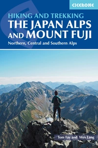
Hiking and Trekking in the Japan Alps and Mount Fuji
Northern, Central and Southern Alps
£22.95
English-language guidebook to the Japan Alps, featuring 27 walks and treks in the North, Central and South Alps, and the Mt Fuji area. Routes range from short, easy walks to long, tough treks and thrilling scrambles. Covers popular areas of Hakuba, Tateyama, Kamikochi, Kawaguchiko. With full information on travel, camping, mountain huts and more.
More information