Trekking in the Bernese Oberland: a complete planning guide
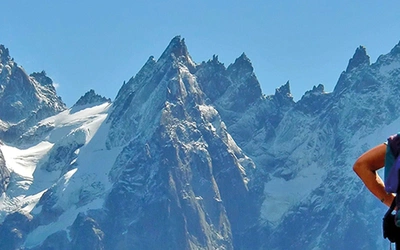
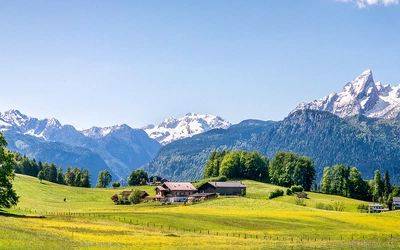
Stand on the wooden balcony of any mountain inn in the Bernese Oberland on a clear summer morning and you will understand why generations of walkers have made this corner of Switzerland the great cathedral of the Alps. The Eiger, Mönch and Jungfrau line up to the south in a dazzling parade of rock and ice. Cowbells drift up from a flower-filled alp. A train clings to the cliff somewhere far below. And striking out from the door, ribbon-thin paths rise across the grass and into the high passes, leading to a hut you will sleep in tonight. This guidebook brings together five of those routes in a single volume: from the 119km Tour of the Jungfrau Region, a glorious first Alpine trek on excellent paths with sustained mountain views, to tougher loops in genuinely wilder terrain to the west. Most treks are completable in under a week. (Last updated: June 2026 · Guidebook edition: First edition, June 2026)
Trekking in the Bernese Oberland, quick facts:
- Routes covered: 5 multi-day alpine treks
- Distances:61km (Wildhorn, 4 stages) to 127km (Wildstrubel, 6 stages)
- Duration:4 to 9 days per trek
- Stages: 4 to 9 per trek (alternatives available on several routes)
- High point: Schilthorn summit, approx. 2970m (TJR Stage 5); Hohtürli 2778m (Bärentrek Stage 5)
- Difficulty: Moderate to Challenging (TJR and Via Berna: moderate; Bärentrek, Wildstrubel, Wildhorn: fairly tough)
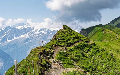
- Terrain: Well-signed mountain paths, high passes, alpine meadows, glacier-view ridges, deep glacial valleys; no alpine (blue-sign) paths used
- Waymark: Red/white Bergwanderweg throughout; Bärentrek follows Via Alpina National Route 1; Via Berna follows Swiss National Route 38
- Accommodation: Mountain huts (Hütten), traditional mountain inns, valley hotels
- Best season: Mid-June to late September; September recommended for settled weather and quieter trails
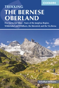
- Guidebook:Trekking in the Bernese Oberland by Jonathan Williams, First edition, £18.95 printed / £18.95 eBook
Trekking in the Bernese Oberland
Five hut-to-hut hikes - Tours of the Jungfrau Region, Wildstrubel and Wildhorn, the Bärentrek and the Via Berna
£18.95
Guidebook to hiking in Switzerland's Bernese Oberland, featuring five alpine treks of four to nine days. The Tours of Jungfrau, Baren, Via Berna, Wildstrubel and Wildhorn explore the region's breathtaking mountains, valleys, lakes, glaciers and waterfalls. Includes accommodation listings and trip planning advice.
More information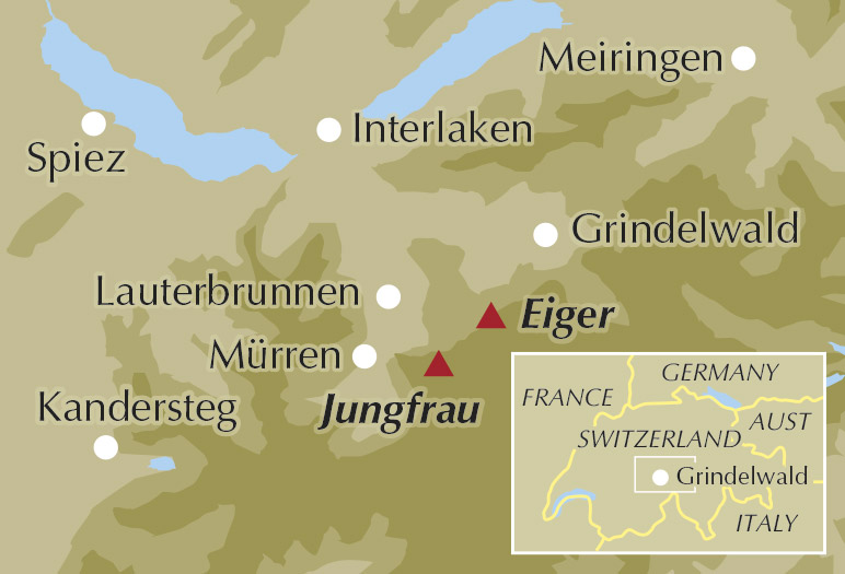
What is Trekking in the Bernese Oberland?
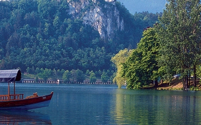
The Bernese Alps form the second-largest cluster of high mountains in Switzerland, stretching some 200km east to west and nearly 100km north to south between the Aare and the Rhône. They contain nine peaks above 4000m and a further forty above 3500m, the longest glacier in the Alps, and the first UNESCO World Natural Heritage Site to be designated in the range. They also contain, in the view of those who have spent years walking them, some of the very finest hut-to-hut trekking routes anywhere, served by a network of trails, cableways and rail links so superbly organised that the practicalities of a multi-day walk fall almost magically into place.
Trekking in the Bernese Oberland gathers five of those routes in a single volume, from a week-long alpine classic beneath the famous north faces to a tougher loop of the Wildstrubel's glaciated massif and a remote four-day circuit of the Wildhorn in the quieter western Bernese Alps. The Tour of the Jungfrau Region is the centrepiece and makes a glorious first Alpine trek. The Bärentrek is the central Oberland section of Switzerland's grand Via Alpina traverse. The Via Berna links the Thunersee to the remote Sustenpass. The two western tours venture into terrain that is less visited and, in English at least, far less well documented online. Together, the five routes offer more than a month of mountain walking, each one distinct in character.
What makes all five routes work so well in practice is the texture around them. Accommodation runs the full range from hay-loft mountain refuges to traditional Berghotels and comfortable village hotels. Trains, postbuses and cable cars reach almost every valley head, which means a short day, a rest day or a poor-weather plan is never far away. Waymarking throughout is excellent. As Jonathan Williams notes in the guidebook, you are rarely more than a couple of hours from a village, and rarely more than a few minutes from a strong view.
This planning guide answers the most common questions walkers have before setting out. For complete stage-by-stage route descriptions and mapping, see the Trekking in the Bernese Oberland guidebook by Jonathan Williams.
Which treks are in the Bernese Oberland guidebook?
Tour of the Jungfrau Region (TJR)
119km · 9 stages · ±8250m ascent and descent · circular from Grindelwald
| Stage | Distance | Ascent/Descent | Time |
|---|---|---|---|
| 1 – Grindelwald to Kleine Scheidegg | 14.0km | +1460m / −430m | 5hr 30min |
| 2 – Kleine Scheidegg to Stechelberg | 14.5km | +270m / −1420m | 5hr |
| 2A – Kleine Scheidegg to Stechelberg via Wengen | 16.4km | +170m / −1320m | 4hr 30min |
| 3 – Stechelberg to Obersteinberg | 11.7km | +1350m / −480m | 5hr 30min |
| 4 – Obersteinberg to Rotstock Hut | 9.3km | +1030m / −770m | 4hr 45min |
| 5 – Rotstock Hut to Mürren via the Schilthorn | 13.2km | +1000m / −1400m | 6hr |
| 6 – Mürren to Lobhorn Hut | 10.7km | +830m / −515m | 4hr 15min |
| 7 – Lobhorn Hut to Schynige Platte | 14.8km | +1330m / −1300m | 7hr |
| 8 – Schynige Platte to First | 16.6km | +870m / −685m | 6hr |
| 9 – First to Grindelwald | 14.2km | +110m / −1250m | 4hr |
| 9A – First to Grindelwald via Berghaus Bäregg | 23.6km | +890m / −2030m | 8hr 30min |
The TJR loops anti-clockwise from Grindelwald around the great mountain wall, threading under the Eiger Nordwand to Kleine Scheidegg, past the wild upper reaches of the Stechelberg valley, through the Sefinental and over the Schilthorn (Piz Gloria of James Bond fame), then east along the panoramic ridge above Schynige Platte to First and back to Grindelwald. Days average under 6 hours of walking and the route can be slowed by an extra night at Obersteinberg, shortened by using the train down from Wengen, or extended with a side trip up the Jungfraujoch railway.
Stage 5, crossing the Schilthorn at nearly 3000m, is the dramatic centrepiece. Stage 8, the high traverse from Schynige Platte past the Faulhorn to the Bachsee and First, is widely regarded as one of the finest ridge walks in Switzerland: wild and remote, with the full panorama of the Bernese range spread to the south. The optional Stage 9A via Berghaus Bäregg (8hr 30min, 23.6km) extends the final day with exceptional glacier views above the Gletscherschlucht gorge.
Those who want shorter outings from the same bases rather than a multi-day circuit will find Walking in the Bernese Oberland: Jungfrau Region by Jonathan and Lesley Williams a useful companion volume, covering day walks around Grindelwald, Lauterbrunnen and Mürren.
The Bärentrek
82km · 5 stages · +6120m / −5550m · linear: Meiringen to Kandersteg
| Stage | Distance | Ascent/Descent | Time |
|---|---|---|---|
| 1 – Meiringen to Hotel Wetterhorn | 19.1km | +1430m / −800m | 7hr |
| 2 – Hotel Wetterhorn to Wengen | 20.7km | +1200m / −1160m | 6hr 45min |
| 3 – Wengen to Rotstock Hut | 15.3km | +1370m / −610m | 6hr |
| 4 – Rotstock Hut to Oberi Bundalp (Griesalp) | 12.7km | +1060m / −1260m | 5hr 45min |
| 5 – Oberi Bundalp to Kandersteg | 14.4km | +1060m / −1720m | 6hr 30min |
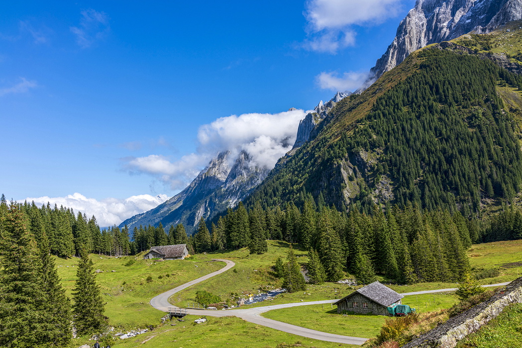
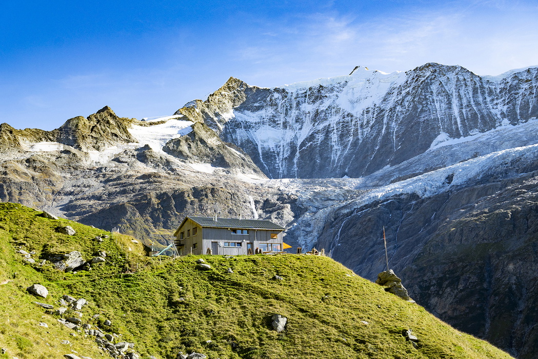
The Bärentrek is the central Oberland section of the Via Alpina, Switzerland's grand 400km east-to-west traverse. The first three stages carry you under the Wetterhorn into Grindelwald and on through Wengen and Mürren, with all the comforts and transport options of the central Oberland. The last two carry you into thinner air over two notable passes: the rocky Sefinafurgga (2611m) and the dramatic Hohtürli (2778m), the most demanding pass crossing in the guide. The Blümlisalp Hut sits directly above the Hohtürli col; below it the Oeschinensee unfolds in its astonishing glacial-green, and Kandersteg lies two long descents away. A real trek with real climbs, but on signed paths with huts and inns at every overnight.
Walkers who complete the Bärentrek and want to continue further along the full Via Alpina can plan the complete route using the Cicerone guide Trekking the Swiss Via Alpina, which covers all 19 stages of National Route 1 from Vaduz to Montreux.
Via Berna (Oberland stages)
122km · 9 stages · +8280m / −6920m · linear: Spiez to Sustenpass
| Stage | Distance | Ascent/Descent | Time |
|---|---|---|---|
| 1 – Aeschi bei Spiez to Saxeten | 17.3km | +1150m / −910m | 6hr 30min |
| 2 – Saxeten to Isenfluh | 13.2km | +1050m / −1070m | 5hr 30min |
| 3 – Isenfluh to Schynige Platte | 10.5km | +1340m / −440m | 5hr |
| 4 – Schynige Platte to First | 16.6km | +870m / −690m | 6hr |
| 5 – First to Rosenlaui | 12.6km | +150m / −990m | 3hr 30min |
| 6 – Rosenlaui to Reuti | 11.0km | +490m / −760m | 3hr 45min |
| 7 – Reuti to Engstlenalp | 18.6km | +1500m / −720m | 7hr |
| 8 – Engstlenalp to Gadmen | 12.2km | +590m / −1230m | 5hr |
| 9 – Gadmen to Sustenpass | 10.0km | +1140m / −110m | 4hr 15min |
Something quieter and more reflective than the TJR. The Via Berna is Swiss National Route 38, and this mountain section covers about 40% of the complete 300km+ traverse of Canton Bern. It shares only a couple of stages with the better-known routes, so for walkers who already know the headline mountains it offers a chance to see them from new angles and link them to country that is genuinely off the standard map. There is an almost old-fashioned pleasure in walking from a steamer pier on Lake Thun one morning and, eight days later, sitting by an empty pass road with the mountains of central Switzerland opening ahead.
Tour of the Wildstrubel
127km · 6 stages · ±7500m · circular from Kandersteg
| Stage | Distance | Ascent/Descent | Time |
|---|---|---|---|
| 1 – Kandersteg to Adelboden | 16.5km | +1400m / −1220m | 6hr 50min |
| 2 – Adelboden to Iffigenalp | 22.5km | +1280m / −1050m | 7hr 30min |
| 3 – Iffigenalp to Crans-Montana | 22.6km | +1390m / −1470m | 8hr |
| 4 – Crans-Montana to Leukerbad | 23.4km | +1090m / −1190m | 7hr 40min |
| 5 – Leukerbad to Lauchernalp | 20.3km | +1670m / −960m | 7hr 40min |
| 6 – Lauchernalp to Kandersteg | 21.7km | +670m / −1610m | 7hr 20min |
| Alt. 5/6A – Leukerbad to Kandersteg via Gemmipass | 20.6km | +1090m / −1310m | 7hr |
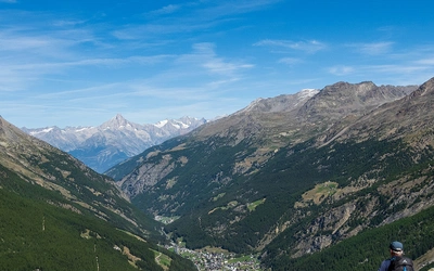
A properly varied tour, taking in two cantons, two languages and a striking change of light between the green northern slopes and the sun-warmed Valais. From Kandersteg the route crosses the Bunderchrinde into Adelboden, swings via Iffigenalp and the Rawilpass (2400m) into Valais, drops to Crans-Montana with its sublime Pennine Alps panorama and on to the spa town of Leukerbad, and returns by one of two excellent finishes: a crossing of the bare rock plateau of the Gemmipass (reducing the trek to five days), or the longer line through the secretive Lötschental and over the Lötschenpass (2689m) into the wild Gasterntal. Six stages averaging roughly 21km and 7.5 hours make this the most physically demanding of the five routes. English-language information on the Wildstrubel circuit is patchy online; the guidebook provides the most complete self-guided resource currently available.
Tour of the Wildhorn
61km · 4 stages · ±4550m · circular from Iffigenalp
| Stage | Distance | Ascent/Descent | Time |
|---|---|---|---|
| 1 – Iffigenalp to Geltenhütte | 12.6km | +1190m / −775m | 5hr 30min |
| 2 – Geltenhütte to Hotel du Sanetsch | 23.8km | +1615m / −1570m | 9hr |
| 3 – Hotel du Sanetsch to Cabane des Audannes | 12.0km | +1135m / −675m | 6hr |
| 4 – Cabane des Audannes to Iffigenalp | 12.6km | +610m / −1530m | 6hr |
The shortest of the five routes but should not be underestimated. From Iffigenalp above Lenk the route ventures into a remote pocket of the western Bernese Alps under the Wildhorn and the distant Diablerets, with a 2900m pass, fixed ladders and chains on Stage 3, a night at the wonderfully isolated Geltenhütte and the Cabane des Audannes set deep in a Valaisan amphitheatre. Stage 2 is the longest single day in the guide (9hr, 23.8km). For walkers who want a long weekend in genuinely wild terrain, with sharp cols, rare mountains and almost no other trekkers, it is hard to beat. Like the Wildstrubel, the Wildhorn is sparsely covered in English online; finding reliable, current route and accommodation information outside this guidebook is difficult.
See the Trekking in the Bernese Oberland guidebook for full stage descriptions, mapping and accommodation listings for all five routes.

How difficult are the Bernese Oberland treks? Who are they suitable for?
The five treks divide clearly into two difficulty bands.
Moderate and well-suited to first-time hut-to-hut trekkers:
The Tour of the Jungfrau Region is the recommended starting point. Days average under 6 hours, paths are excellent throughout, most stages have access to valley transport if conditions turn, and accommodation is plentiful. It is a medium-difficulty challenge: a couple of stages are fairly remote (Stage 3 to Obersteinberg, Stage 8 from Schynige Platte to First), and the Schilthorn ascent on Stage 5 can be testing in poor weather, but under normal summer conditions no special gear is required. It makes a great introduction to Alpine trekking, often described as more accessible than the Tour du Mont Blanc: the mountain scenery is at least as dramatic, and the infrastructure is exceptional. Walkers planning their first Alpine circuit and wanting a comparison should read the Cicerone guide Trekking the Tour du Mont Blanc alongside this one. The Via Berna is similarly graded, with some long climbs and descents but consistent waymarking and strong transport links throughout.
Fairly tough, better suited to walkers with some prior Alpine or hut-to-hut experience:
The Bärentrek has demanding early stages (7hr, 19–21km) and finishes with two serious passes. The Tour of the Wildstrubel involves consistently long days of around 7–8 hours, with the northern approach to the Rawilpass potentially affected by late-lying snow. The Tour of the Wildhorn is compact but technically demanding: Stage 2 is the longest day in the guide, Stage 3 includes laddered and cabled sections, and crampons may be advisable in early season. Both the Wildstrubel and Wildhorn suit walkers who have completed the TJR and want something less frequented and more physically committed.
For all five routes, walkers should be comfortable on mountain-grade (red/white) paths and capable of sustained ascents of over 1000m in a day. No glacier crossings or scrambling on blue alpine paths are required on any route. Regular mountain walkers will find the TJR and Via Berna well within their abilities from the outset.
Can I walk a shorter section of the Bernese Oberland treks?
The TJR is the most flexible route for shorter itineraries. Alternative stages (2A, 7A and 9A) allow walkers to vary difficulty and length, and the outstanding transport network means the route can be joined or left at Grindelwald, Lauterbrunnen, Wengen or Mürren with ease. Walkers with five or six days can complete the core circuit by combining a couple of shorter stages or taking the cable car to Kleine Scheidegg on Stage 1.
The Bärentrek can be compressed to its most dramatic three days by taking transport from Wengen to Mürren and beginning the climb to Rotstock Hut from Lauterbrunnen. The Via Berna's linear structure and reliable rail access at both Spiez and Sustenpass make it well suited to walking in sections; Stages 1–3 can also be combined using intermediate transport to save a day.
The Wildstrubel can be accessed at Adelboden, Lenk or Leukerbad as well as Kandersteg, and the Gemmipass variant reduces it to five days. The Wildhorn's remote terrain makes mid-route entry more difficult, though the route can be started at the Col du Sanetsch or from Crans-Montana for those approaching from the south.
When is the best time to trek in the Bernese Oberland?
- Mid-June to late June: Huts open as snow clears from the lower passes. Some higher passes may still carry snow; microspikes are a sensible addition to your pack. Flowers are at their finest, with snowbells and crocuses giving way to the first gentians.
- July to mid-August: The main Swiss holiday season. Weather generally good but paths and accommodation in the central Oberland are busy. Book well in advance; the Bernese Oberland stages of the Via Alpina fill earliest, particularly around Grindelwald, Wengen and Mürren.
- Late August to mid-September: Often the best balance of settled weather and quieter trails. From the end of August a dump of snow becomes more likely and can sometimes settle for a week or more. Alpine roses cover the hillsides; bilberries ripen on the descent.
- September: Jonathan Williams's recommended month, and widely regarded as the finest time for trekking in the region: past the summer heat, quieter on the trails, longer clear spells. Most accommodation closes at the end of September.
- October onwards: Huts and mountain inns close for winter. High passes become wintry. The trekking season is effectively over.
The Bernese Oberland is the first part of the Alps to catch north-westerly weather systems, which can stack against the mountain wall for a day or two. Good waterproofs are essential but may spend the entire trip in your pack. Afternoon thunderstorms are possible in high summer: starting early and arriving at accommodation by early afternoon is consistently good practice.
What accommodation is available on the Bernese Oberland treks?
Mountain huts (Hütten/refuges) are the primary form of accommodation at higher altitude. Most offer dormitory sleeping (Matratzenlager) as the cheaper option alongside small shared rooms. Meals are served communally from a set menu; ask early if you need a packed lunch for the following day. Showers are almost always available. Members of the Swiss Alpine Club (SAC) and affiliated clubs (including the Austrian Alpine Club and the British Alpine Club) may qualify for reduced rates in SAC huts. Book by phone, email or online reservation form, especially in high summer.
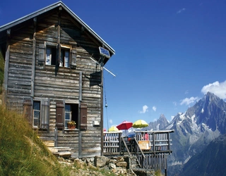
Mountain inns (Berghaus, Berggasthaus, Berghotel, Gasthaus) are a particular feature of the Bernese Oberland, with the same families welcoming walkers for three and four generations. They offer private rooms with shared bathrooms, meals from a set menu, and usually dormitory accommodation on request. Among the most memorable on the TJR are the Schynige Platte hotel, an Edwardian building at the top of an 1890s rack railway with an extraordinary glass dining hall; the Berghotel Faulhorn, one of the oldest mountain hotels in Switzerland; the Lobhornhütte, spectacular at sunset once the day visitors have left; and the remote Berghaus Obersteinberg, deep in the upper Lauterbrunnen valley.
Valley hotels in the main centres range from modest and functional to genuinely grand. Adelboden and Crans-Montana are well-known ski resorts and priced accordingly; Kandersteg offers better value. Leukerbad is primarily a spa town, well worth a long soak if you are staying there overnight.
Book as early as possible, ideally several months ahead for high summer. A full accommodation list is provided in Appendix A of the Trekking in the Bernese Oberland guidebook.
How do I get to the Bernese Oberland?
The region is one of the easiest serious mountain areas to reach. The airports at Zurich, Basel and Geneva all have rail connections to Interlaken, Spiez, Meiringen and Kandersteg. A walker leaving home at dawn can be at a hut by suppertime. Eurostar and TGV services link the same gateways from London and Paris in around eight hours for those who prefer to travel without flying.
By train: Swiss Federal Railways (SBB) run fast, reliable services from Geneva, Basel and Zurich, reaching Interlaken in around 2 hours 30 minutes. All timetables and tickets are bookable through the SBB Mobile app at sbb.ch. Note that on the Interlaken train, the service splits at Zweilütschinen: one section heads to Grindelwald, the other to Lauterbrunnen. Check you board the correct carriage.
By air: Geneva and Zurich have extensive European and international connections with integrated rail stations. Basel-Mulhouse offers a growing range of short-haul routes and connects to the city centre by tram.
By car: Switzerland is fully connected to Europe's motorway network. A motorway vignette (currently CHF40) is required, available online or at border crossings. Long-stay car parks exist in Interlaken, Grindelwald and Lauterbrunnen, but the local transport network is excellent and a car adds relatively little once you are in the region.
Discount passes: The Swiss Travel Pass, Berner Oberland Pass and Jungfrau Travel Pass each offer different combinations of rail and lift discounts, and most walkers find one of them more than pays for itself. A visit to the Jungfraujoch (around CHF250 at standard price) is an excellent if expensive side trip; compare pass options carefully before buying tickets. See Appendix B of the Trekking in the Bernese Oberland guidebook for full details.
What are the highlights of trekking in the Bernese Oberland?
- The Eiger Nordwand at close range on the Eiger Trail (TJR Stage 1): an epic walk directly beneath one of the great mountain walls in the Alps, passing the slopes where 1930s climbers hid from the Swiss authorities before their Nordwand attempts
- The Schilthorn summit and Piz Gloria (TJR Stage 5): a long ridge approach to nearly 3000m and a 360° panorama from James Bond's revolving restaurant
- The Faulhorn ridge traverse (Schynige Platte to First, TJR Stage 8 / Via Berna Stage 4): widely considered one of the finest high mountain walks in Switzerland, wild and remote with the entire Bernese Alps spread to the south
- Obersteinberg (TJR Stage 3): a remote cluster of traditional inns in the upper Lauterbrunnen valley, where ibex pick across the cliffs and avalanches crash from the glaciers of the Jungfrau far above
- The Hohtürli and the Oeschinensee (Bärentrek Stage 5): the toughest crossing in the guide at 2778m, followed by one of the most beautiful lakes in the Alps
- The Gasterntal and Lötschental (Wildstrubel Stage 6): two quiet, wild valleys reached after the descent from the Lötschenpass, rarely visited and quite different in character from the busy central Oberland
- The flowers at Schynige Platte (TJR Stage 7 / Via Berna Stage 3): the alpine garden above the station holds around 500 of Switzerland's 620 flowering mountain species in a single hillside
Is the Jungfraujoch railway worth visiting?
The Jungfraujoch railway is not part of any trek in the guide, but for anyone with time at Kleine Scheidegg or Grindelwald, the question is almost inevitable. Designed by Adolph Guyer-Zeller and completed in 1912 after 16 years of construction, the line climbs through the interiors of the Eiger and Mönch on a 1:4 gradient to the 3454m Jungfraujoch terminus, Europe's highest railway station. From the Sphinx Terrace, on a clear day, views extend to Germany's Black Forest and the Italian Alps. Below, the 23km Grosser Aletschgletscher, the longest glacier in the Alps, flows south from the Jungfraufirn snowfield.
The cost is significant (around CHF250 at standard price) and good visibility is essential: check the forecast before investing in a ticket. Several discount passes offer savings. Trains run from Grindelwald and Lauterbrunnen via Kleine Scheidegg. See Appendix B of the Trekking in the Bernese Oberland guidebook for details on passes and discounts.
Plan your trek with the Cicerone guidebook
Trekking in the Bernese Oberland by Jonathan Williams contains everything you need to plan and complete all five routes, from the train to Grindelwald to the final cable car home. The guidebook includes:
- Full stage-by-stage route descriptions for all 5 treks across 33 stages (including alternatives), with daily distances, ascent and descent figures, and practical notes
- A route summary table covering all five treks at a glance, plus per-trek stage planners showing facilities available along each route
- Comprehensive accommodation listings for huts, mountain inns and valley hotels (Appendix A), with booking guidance
- Transport and access information, including Switzerland's integrated rail, bus and cable-car network and detailed guidance on discount passes
- Recommendations for Swiss Landeskarte mapping at 1:25,000 and 1:50,000, plus the two Kümmerly+Frey 1:60,000 Wanderkarte sheets covering the region (No. 18 Jungfrau and No. 32 Crans-Montana)
- GPX files for all five Bernese Oberland treks, downloadable from your Cicerone account
- The route is also available as a Cicerone app guide for Trekking in the Bernese Oberland
- Extensive preparation information: when to go, fitness and training, equipment, mountain safety, languages, maps and apps
- A dedicated 'Top 10 Tips for a First-Time Alpine Trekker', covering gear, fitness, hut etiquette and managing the unexpected
- Appendices covering contact information, further reading and an English–German glossary
Available as a printed guidebook to Trekking in the Bernese Oberland (£18.95) or digital eBook (£18.95). Publishing date: 15 June 2026.
Trekking in the Bernese Oberland
Five hut-to-hut hikes - Tours of the Jungfrau Region, Wildstrubel and Wildhorn, the Bärentrek and the Via Berna
£18.95
Guidebook to hiking in Switzerland's Bernese Oberland, featuring five alpine treks of four to nine days. The Tours of Jungfrau, Baren, Via Berna, Wildstrubel and Wildhorn explore the region's breathtaking mountains, valleys, lakes, glaciers and waterfalls. Includes accommodation listings and trip planning advice.
More informationAbout Jonathan Williams, guidebook author:
Jonathan Williams has been Cicerone's publisher and managing director for over 20 years, working with authors and leading the development of the range. He has been exploring the mountains of Switzerland for over 25 years. In his new life as an author, he and Lesley Williams have made the Swiss and French Alps their special subject, exploring treks and walks throughout the mountains and turning this passion into a series of guides. In researching this guide, Jonathan has been exploring the Bernese Oberland over the past four years.