Walking in the Julian Alps of Slovenia: a complete planning guide
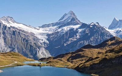
Slovenia's Julian Alps are not as high as their western Alpine relations, but they are no less imposing. Limestone peaks plunge into flower meadows, waterfalls cascade from cliffs and then vanish into the bedrock, and Triglav, the highest summit at 2864m, reigns over what the mountaineer Tom Longstaff once called "a dreamworld, sundered from time." This planning guide covers 40 graded routes across five walking centres, from gentle valley strolls to serious high-mountain days, all drawn from the Cicerone Walking the Julian Alps of Slovenia guidebook by Roberto Lombardo. (Last updated: June 2025 · Guidebook edition: 3rd edition, August 2025)
Walking in the Julian Alps of Slovenia, quick facts:
- Location: Julian Alps, northwest Slovenia, within and around Triglav National Park
- Total routes: 40 (37 day walks, 3 multi-day treks)
- Distance range: 4km (2.5 miles) to 24km (15 miles) for day walks; 18–34km (11–21 miles) for multi-day treks
- Typical duration: 2–11 hours per day walk; 2 days per trek
- Walking centres: Kranjska Gora, Bohinj, Bovec, Bled, Kobarid
- Difficulty: Grade 1 (easy valley walks) to Grade 4 (serious high routes with fixed protection)
- Terrain: Limestone peaks, alpine meadows, forest trails, gorges, lakes and rivers
- Highest point: Triglav, 2864m
- Navigation: 1:25,000 Sidarta maps recommended; free downloadable GPX tracks for all 40 routes
- Best season: Mid-June to late September (huts open July to September; lower routes possible May to October)
- Guidebook: Walking the Julian Alps of Slovenia by Roberto Lombardo, 3rd edition, Cicerone Press
Walking the Julian Alps of Slovenia
Mountain walks and short treks
£19.95
Guidebook describing 40 walks in the Julian Alps of Slovenia. The routes in the Julian Alps range from easy walks to more challenging options, and multi-day treks.
More informationWhat are the Julian Alps of Slovenia?
The Julian Alps occupy the north-west corner of Slovenia, with a small extension into Italy. The range sits at the south-eastern end of the Alpine chain and most of it falls within Triglav National Park, which covers over 84,000 hectares, around 4% of the entire country. The name goes back to Roman times, thought to be linked to the imperial Julian family, and the mountains have been drawing walkers for well over a century.
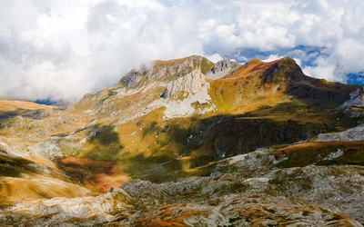
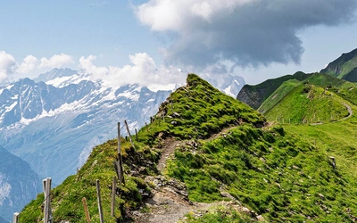
The limestone scenery is the defining characteristic. Steep rock faces drop into forested valleys, hidden gorges carry rivers of astonishing turquoise, and open alpine pastures nestle beneath crags thick with wildflowers whose colours change with altitude but never lose their variety. Walkers familiar with the Dolomites will recognise the drama of the terrain, but the Julian Alps are quieter, less developed, and noticeably less expensive: hut prices are lower, the trails are less crowded even in peak season, and it is still possible to find yourself alone on a high ridge in July. Chamois are a common sight on the high-level walks, golden eagles circle the ridges, and marmots whistle from the scree.
Triglav's hold on Slovenian identity is difficult to convey to an outsider. The peak is considered the soul of the nation, and climbing it at least once is, by tradition, something every Slovene should do. But the Julian Alps are far more than a single summit. A network of well-maintained mountain huts makes multi-day walking straightforward, routes are clearly waymarked throughout, and the grading runs from easy valley strolls to demanding alpine ascents requiring via ferrata equipment. This planning guide covers the key questions walkers ask before setting out. For complete route descriptions and mapping, see the Walking the Julian Alps of Slovenia guidebook.
The 40 routes at a glance
The guidebook divides its 40 routes (37 day walks and 3 multi-day treks) across five walking centres that form a rough circle around the main Julian Alps massif. Each centre has its own character and its own mix of easier and harder routes.
- Kranjska Gora (Walks 1–12) is a winter ski resort that transforms in summer into an excellent base for the full range of alpine walking, from beautiful easy valley trails to some of the most demanding peaks in the range.
- Bohinj (Walks 13–22) is one of the gems of Slovenia: the area around Lake Bohinj offers valley waterfalls, long mountain ridges, and the southern approach to Triglav itself.
- Bovec (Walks 23–31) is the sporty, upbeat town on the Soča River, close to World War 1 sites and some spectacular high-mountain terrain including the ascent of Mangart.
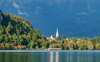
- Bled (Walks 32–36) provides Slovenia's most iconic scenery, with the lake and its island forming the backdrop for lovely viewpoint walks. Kobarid (Walks 37–40) sits in the foothills to the south, with long mountain ridges offering views all the way to the Adriatic.
The table below highlights eight routes across the grade range, chosen for their variety and their prominence among walkers planning a Julian Alps trip.
| Walk | Distance / Time | Ascent | Grade |
|---|---|---|---|
| Triglav: southern approach (Bohinj) | 33.5km / 2 days | 2560m | 4 |
| Tour of Lake Bled and Osojnica | 9.1km / 3 hrs 30 mins | 390m | 2 |
| Vintgar gorge | 9.7km / 3hrs | 300m | 1/2 |
| Soča Trail | 21.7km / 6hr 30min | 220m | 2 |
| Jalovec | 17.6km / 2 days | 1585m | 4 |
| Triglav Lakes valley and Veliko Špičje | 24.4km / 2 days | 1955m | 4 |
| Mangart | 7km / 5hr | 840m | 4 |
| Tour of Lake Bohinj | 11.6km; 19.2km via Savica waterfall / 3hr 45min; 5hr 45min via Savica waterfall | 205m; 530m via Savica waterfall | 1 or 1/2 via Savica waterfall |

How difficult is walking in the Julian Alps?
The Julian Alps use a four-point grading system specific to this guidebook.
Grade 1 routes are easy walks of no more than 3–4 hours, with little height gain. They are ideal as an introduction to the area and suit almost all walkers, including families with older children. The Tour of Lake Bled and the Tour of Lake Bohinj both fall into this category.
Grade 2 routes are longer, over rougher ground, with some height gain. There is no scrambling, but paths can be steep and rocky in places. The Soča Trail is a good example: rewarding and manageable for fit walkers without technical experience.
Grade 3 routes are full mountain days with significant height gain, rough terrain and possibly a short scrambling section or two. A good level of fitness is essential.
Grade 4 routes are serious alpine undertakings, long and strenuous, often exposed, and almost always involving fixed protection in the form of steel pegs and cables. Self-belaying (via ferrata) equipment and a helmet are strongly recommended. These routes, including the ascent of Triglav and the approach to Jalovec, require a high level of fitness and competence in general mountaineering skills.
The limestone nature of the Julian Alps means the terrain is frequently steep and the rock can be loose. Once above the valleys, even relatively low-level paths cross rocks and tree roots; higher up, loose rock, scree and exposed sections are common. Walkers attempting any of the higher or longer routes should be fit, comfortable at heights, competent scramblers, and aware that the weather can change rapidly.
Who is walking in the Julian Alps suitable for?
Grade 1 and 2 routes are genuinely accessible. The lake circuits at Bled and Bohinj, the Vintgar gorge walk, and the valley routes around Kranjska Gora all involve modest height gain on clear paths, and suit walkers who have no alpine experience. Families with older children, those returning to walking after a break, and anyone who simply wants to spend a day in beautiful surroundings without technical challenge will find plenty here.
Intermediate walkers comfortable on rough, steep ground will find the Grade 3 routes among the most rewarding in the Alps. The Triglav Lakes valley, the Lower Bohinj mountains and the approach to Krn involve real mountain effort without requiring specialist equipment.
Grade 4 routes are a different matter. The ascents of Triglav, Jalovec and Mangart are serious undertakings involving fixed cables and pegs on exposed terrain. Self-belaying kit (harness and two lanyards with energy absorbers) and a helmet are not optional on these routes: they are the minimum requirement. Prior via ferrata experience is strongly advisable before attempting any Grade 4 route in the Julian Alps. The guidebook is explicit on this point, and it is worth taking seriously.
One practical note applies to all walkers: wild camping is illegal throughout Slovenia. Anyone planning an overnight route needs to book mountain hut accommodation in advance, particularly for July and August.
When is the best time to walk in the Julian Alps?
Mid-June to late September is the main walking season. Snow has generally cleared from most routes by mid-June, the high-mountain huts are open from July to September, and the weather is at its most reliable. That said, snow can occur at any time of year, and patches linger all summer in high gullies and on north faces.
July and August are the busiest months on popular routes such as Triglav and around the lakes. The bigger concern in high summer is afternoon thunderstorms, which can build from clear skies in under half an hour on high ridges and summits. An early start is not just advisable but genuinely important on any exposed route.
September tends to be quieter, the light is better for photography, and the hay meadows and forests begin to turn. Many walkers find it the most satisfying month of the season.
May and early June bring wonderful spring flowers on lower routes, but high paths may still be snow-affected, huts are not yet fully open, and the weather can be unsettled.
October suits lower-altitude routes in good years. The autumn colours in the beech and larch forests are excellent, but high routes carry real early-snow risk and most huts will have closed for the season.
Walkers should also note that severe storms in summer 2023 caused significant damage to paths and bridges across the Julian Alps. Most have since been repaired, but checking trail status before setting out via the maPZS app (mapzs.pzs.si) is worthwhile.

What accommodation is available in the Julian Alps?
The mountain hut (dom or koča in Slovenian) is central to walking culture in the Julian Alps. Huts are strategically placed throughout the range, making it possible to walk for days without descending to a valley. All huts are manned during the season (July to September) and serve meals and drinks to passing walkers as well as those staying overnight.
Sleeping accommodation is in dormitories (skupna ležišča) or private rooms (sobe), with rooms more expensive. A sleeping bag liner is required; these can be rented at huts for an additional fee. Prices are reduced for members of the Alpine Association of Slovenia (PZS), and reciprocal arrangements exist with some other national alpine clubs. Budget around €75 per person per day for hut accommodation, food and drink. Many huts now accept credit cards, but cash is advisable as connectivity is not always reliable.
Higher huts may have limited water (rainwater only), no espresso machines, and limited phone-charging facilities; carrying a power bank is recommended. In good weather in July and August, popular high huts fill quickly and advance booking is strongly advised. In bad weather, no one is ever turned away, even if it means sleeping on the floor. Booking for several Julian Alps huts is now available online via the PZS website (www.pzs.si).
In the valley bases, accommodation ranges from hotels and pensions to private rooms (sobe), apartments (apartmaji), tourist farmhouses (turistične kmetije) and hostels. Campsites are clean and well-equipped at all five bases; wild camping is illegal throughout Slovenia.
For a complete, up-to-date list of huts, their opening dates and contact details, see the PZS website and the guidebook appendix.
Do the Julian Alps have via ferrata routes?
Several of the Grade 4 routes in the guidebook involve sections of fixed protection, including steel pegs (klini) and cables, in the style of a via ferrata. These sections provide security on the most exposed terrain but do not remove the technical challenge: walkers need to bring and use self-belaying equipment (harness, two lanyards with energy absorbers) and a helmet. Stout gloves are also recommended.
Via ferrata kit can be hired locally from some sports shops and outdoor agencies, but availability is not guaranteed. Check with local tourist information offices before relying on hire equipment. If you are new to via ferrata, consider tackling a lower-grade protected route before attempting the more serious ascents such as Triglav or Jalovec.

How do I get to the Julian Alps of Slovenia?
By air: Slovenia's main international airport is at Brnik (LJU), 23km north of Ljubljana and 1–2 hours by road from the main walking centres. Budget airlines serve major European cities. Venice, Trieste, Zagreb and Klagenfurt airports are alternatives, particularly useful for those driving or combining the Julian Alps with other destinations.
By train: Bled and Bohinj (Bohinjska Bistrica) lie on the main rail corridor between Munich and Trieste and are straightforward to reach by rail. Kranjska Gora is accessible from the international rail junction at Jesenice via regular bus connection. The nearest station to Kobarid and Bovec is at Most na Soči, also served by bus.
By bus: FlixBus connects Slovenia with many European cities (www.flixbus.co.uk). Within Slovenia, an efficient modern bus network links all five walking centres, with additional seasonal services added by tourist offices during summer. Timetables at www.arriva.si and www.nomago.si.
By car: Slovenia's motorway network connects all major centres. A vignette (toll sticker) is required for motorway driving; buy online at evinjeta.dars.si or at the border. A car adds flexibility, particularly for early starts on high routes and for reaching trailheads not well served by bus.
The Julian Alps Card is available in Bled, Bohinj, the Soča valley and Radovljica, offering free or reduced-price transport, parking, and entry to attractions. Cards are purchased at tourist information centres and some accommodation providers.
Walking the Julian Alps of Slovenia
Mountain walks and short treks
£19.95
Guidebook describing 40 walks in the Julian Alps of Slovenia. The routes in the Julian Alps range from easy walks to more challenging options, and multi-day treks.
More informationPlan your Julian Alps walks with the Cicerone guidebook
Walking the Julian Alps of Slovenia by Roberto Lombardo is the most comprehensive English-language guide to this part of Slovenia, now in its 3rd edition (August 2025). It covers:
- 40 fully described and graded routes (37 day walks, 3 multi-day treks) across five walking centres
- Route descriptions with grade, distance, ascent, start/finish, public transport and refreshment information for every walk
- 1:50,000 overview mapping plus recommended 1:25,000 Sidarta map references
- Free downloadable GPX tracks for all 40 routes
- Practical information on accommodation (mountain huts, hotels, campsites), food and drink, transport, equipment and mountain safety
- An introduction to Triglav National Park, long-distance routes crossing the Julian Alps, wildlife and flowers, and the history of the Soča Front
- Language notes and glossary (Appendix B) and useful contacts (Appendix A)
Available as a printed guidebook (£19.95) or digital eBook.
About Roberto Lombardo, guidebook author
Born and raised in Trieste in a bilingual Italian-Slovenian family, Roberto's imagination wandered in search of places and adventures from an early age. As soon as he was old enough, he started travelling independently and hasn't stopped since. His love of nature, adventure and the unknown has taken him to the trails of almost every continent and to the lecture halls of anthropology universities to study different cultures. His heart, however, has always been anchored to his homeland, the Slovenian mountains and the green forests that surround them. It is from this love that this new edition of the guide was born. To give shape to his passions, Roberto, together with his wife Martina, runs the outdoor travel agency MaroWays, which for years has accompanied hikers and travellers to discover the wonders of Trieste, Slovenia and the Balkans.
This edition builds on the foundation laid by Justi Carey and Roy Clark, whose intimate knowledge of the Julian Alps, gained from living in Slovenia's mountainous north-west, shaped earlier editions of this guide.