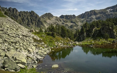
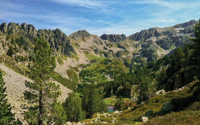
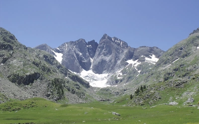
13 Parc Nacional Daiguestortes
Parc Nacional d'Aiguestortes

Trekking in the Parc Nacional D’Aigüestortes in the Spanish Pyrenees

When Clive and Jennifer Darley were invited by their colleagues Kath and Simon to join them for a trek through the Spanish Pyrenees, they accepted with enthusiasm. Simon is a gifted linguist who speaks Spanish, Catalan and French fluently. The quid pro quo was that they have over 50 years’ trekking experience. It seemed an ideal combination.

Throughout our professional lives we have been fortunate to be in the company of young people whose energy and optimism we have shared and whose talents in many cases we have envied. Many have accompanied us on walks and treks over the past 55 years.

Our adventure with Kath and Simon began in September at Bagneres Luchon, from where we took a taxi over the border to Vielha in Spain. The starting point of the trek was the Hospitau de Vielha, which lies at the end of a 5/6km tunnel, linking the enclave of Vielha with the rest of Spain. It was a glorious morning to begin such an adventure. We set off through the distinctive open coniferous woodland, climbing steadily around a pinnacled corrie wall to reach the Port de Rius at 2340m.

The warmth of the sun and the cascades of butterflies combined with the scent of suntan lotion and sweat, brought back memories of countless Alpine treks. Years before we had walked the GR10 across the Pyrenees, but we had never trekked solely in Spain. The landscape here was certainly distinctive, the juxtaposition of austere, scoured slopes, still holding a little snow, contrasted with the fading Alpine flowers, chiefly scabious, monk’s hood and harebell. From the col, the gradual descent into the Rius valley opened up a vista of glittering lakes (estanyi) and deep purple, shattered peaks, which was to prove a characteristic combination in the days ahead.

The day had a sting in its tail; a steep and relentless ascent to the Refugi dera Restanca sapped most of our remaining energy. Fortunately, we had booked places at the hut, which was an imposing building catering for 70 people at the head of a dammed lake. It was our first introduction to the rhythms and ambience of the Spanish mountain huts.

GR11 Lac de Ruis
GR11 Lac de Ruis

An early start

Breakfast was taken at 7am to allow for a much earlier and cooler start to the second day.

The view from the Col de Crestada was stunning; lakes and mountains in different hues of blue, the plangent, sonorous sound of cowbells and the refreshing tonic of invigorating mountain air.

It was a good place to rest and to savour, but eventually we set off again, heading for the Port de Caldes at 2570m. The GR 11 we were following was well marked. Glaciated landscapes of polished and smoothed rock, acres of frost-shattered scree blocks and scores of delightful tarns nestling in ice-hollowed depressions were characteristic. The ascents and descents were short but demanding and having reached the summit of the final col, the path could be seen far below, snaking its way along the flat-floored valley.

Our destination was the Colomers Refuge, perched above a lake, which clearly was of an older vintage than Restanca. Its toilet facilities were bizarre and involved making one’s way down steps cut in a rock buttress to a small chamber where a hole in the rock, disinfected by running water from a pipe, discharged waste a good 200ft into the lake below. It was positively lethal, particularly in the early hours, not to say unhygienic!

Coll de Crestada
Coll de Crestada

The walk out the next day began with a traverse across the dam and, after a short ascent, the view opened out into a pretty valley garlanded with lakes, through which the path threaded its way. The climb up to the Port de Ratera was well graded and steady, culminating in a broad and open plateau surrounded by rocky spires and shattered scree slopes. To the south and east, granitic towers punctuated an austere but spectacular mountain landscape; overhead, flocks of vultures glided effortlessly among the crags. To our surprise the barking of a dog drew our attention to a cameo scene as a large white Pyrenean hound manoeuvred a young chamois down the polished buttresses below the lip of the giant corrie.

By now the weather was clearly on the turn, the crystal clarity of the first three days being replaced inexorably by glowering cloud. Continuation down the GR 11 to Espot seemed a less desirable option than diverting to the Amitges Refuge, which nestled at the head of a lake in the neighbouring valley. This proved to be a good decision. The hut is accessible by 4x4 vehicles, is beautifully situated and very well equipped. The lake (Estany Gran d’Amitges) is overlooked by twin granite towers (Aiguilles d’Amitges) and the embracing corrie wall is studded by turrets and weird shaped blocks in various stages of incipient collapse, which gives the skyline a distinctive serrated look.

The storm finally broke in the early evening, but by then we were savouring another excellent evening meal with wine. Amitges was to prove one of my favourite huts on the trek – welcoming, comfortable and with excellent food.

The perfect view

The following morning dawned fresher and cooler as we set off down the track to Sant Maurici and Espot. Mountain pines framed the granite obelisks ahead of us, of which the Encantats were the most spectacular. Mist hung round many of the higher peaks like diaphanous garlands. Along the track small groups of chamois skipped among the boulders by the stream before settling down to graze. Overhead, squadrons of vultures continued to circle among the turrets of the higher corries. It was tranquil and serene. The small lakes, with their beds of reeds, framed the view to perfection.

We left the track to reach the Estany de Sant Maurici by the old footpath, which wended its way through the woods, crossing the waterfalls before reaching the lakeside. The twin columns of the Encantats rose above the lake like wedded sentinels, the mists still weaving their way along the crests and up the deep gullies and ravines. It felt strange to be among cars and groups of people again. The peace and serenity of the high mountains has an allure that is fragile. However, we wandered down the valley, rejoining the GR 11 as it headed towards Espot. Traversing hillsides still alive with flowers and insects gave an insight into a way of life that has clearly disappeared. Old stone walls and laboriously constructed terraces on these south-facing slopes are now derelict and over-run with scrub and brambles. Only on one terrace was there evidence of active farming as the sound of bells revealed a herd of goats tended by a shepherd and his dog.

It took about two hours to reach Espot, which was a small and ancient village, where the contrast between the old barns and farmhouses and the gentrified buildings and new apartments was only too stark. As in the Lake District, the decline of traditional economic activity, greater mobility and the demand for second homes has had an inevitable effect.

Completing the circuit of the Aigüestortes National Park back to the Val d’Aran meant climbing up a stony track in persistent drizzle to the Refugi JM Blanc. This hut was splendidly located on a promontory jutting out into Estany Tort. Around the lake, mountain pines dotted the lower slopes and below it the mists continued to writhe in the Espot valley. It did not take long, however, for the sun to ease its way through the banks of cloud and, with this encouragement, we set off to explore the various lakes above the hut.

Problems of route finding caused some frustration initially, but we eventually picked up a ghost of a path through the boulders, which led us to our first tarn (Estany de la Cabana). The waters of the lake in the sunshine looked impossibly pure and blue-green. Above us, we watched a small herd of chamois (adults and fawns) ascend the scoured granite outcrops in their elegant, confident manner. Climbing higher and with some degree of circumspection regarding the route, we eventually reached the Estany de la Coveta in whose unruffled waters the surrounding granite spires were perfectly reflected. Above the lake we rejoined the GR11 and headed back to the hut, which again proved to be a very welcoming and congenial place to stay.

Refugi d'Amitges
Refugi d'Amitges

A joy to be alive

It was with some regrets that we left the following day to climb one of the highest cols, the Collada de Saburo, at nearly 2700m. The morning was quite stunning. The air was so fresh and sharp that it was a joy to be alive. Doubts about the path were quickly assuaged as we wended inexorably uphill, meandering between rock buttresses and outcrops, with hollows often containing crystal-clear tarns and ponds. It was a steep pull up to the col, but the effort was worthwhile. Ahead lay myriad lakes with surrounding white granite peaks with their aprons of scree and boulders.

In the distance, the mountains were different in shape and colour, more redolent of Lakeland hills with greens and browns, and just discernible in the haze were the foothills and plains of Aragon.

The rest stop was reluctantly terminated as the air became cooler and after a brief descent, the path then degenerated in a maze of giant boulders, which proved a taxing obstacle. Caution was necessary; it was not the place to twist an ankle or worse! Eventually we emerged on the track by the Estany de Saburo, so perfectly round and deep and blue that it could have been a caldera lake. A brief traverse led us to the Pas de l’Os from which a staircase of stone steps brought us to the Estany de Mar. All these lakes are discreetly contained and regulated by dams, but all must have had natural glacial origins.

The Refugi Colomina stands at the head of the lake bearing its name and is a simple wooden cabin perched above the valley below. In the sunshine it made a welcoming sight, but this was a cold place. The draughts whistled into the lounge/dining room and only by donning all clothes, including cagoule and over-trousers, was it possible to feel reasonably warm. Toilet and washing facilities were cramped but the bunks were warm and comfortable. It is curious how the character of each hut was subtly different, but all are hospitable, and the camaraderie engendered by the meeting of people of different ages, nationalities and backgrounds remains a constant feature.

The next destination, Refugi de Estany Llong, was some distance away and again required the ascent of a col at about 2600m. It was with some consternation that we awoke to a morning of almost complete whiteout, with visibility reduced to only a few metres. Constant, careful reference to the map brought us to the shores of the Estany Tort, one of the largest lakes in the park. The mist cleared occasionally to reveal shattered peaks and a real complex of lakes, all linked by dams into a hydro-electric system. The first watery shafts of sunlight pierced the gloom as we began the ascent to the col. The path was steep but mainly grassy and the shallow crest proved to be cool and draughty.

Below, to the north, the trail led down a broad open valley (Vall de Dellui) decorated with its necklace of small lakes. The surrounding granite walls were characteristically splintered and pinnacled, throwing cascades of rubble and scree down the upper slopes. Clusters of the hardy mountain pine softened the austerity of the bare rock and in the distance, the faint sonorous ring of cowbells completed a gentle pastoral scene. It was still a fair way to the refuge, but the path was clear and well marked, even across the boulder fields.

The Refugi d’Estany Llong lies at the head of a park track accessible to 4x4 vehicles, but surprisingly for a Saturday, it was relatively quiet. It was a functional rather than atmospheric place but, again, the food could not be faulted; the duck prepared as the main course of the evening meal would have graced a quality restaurant.

It was quite a poignant evening, partly due to the clarity of the starlit night in which the brilliance of the Milky Way shone clearly, and partly due to the recognition that this would probably be our last night spent in a refuge at altitude.

First frost, last day

We awoke to our first frost of the season and descended a good track through meadows to the accompaniment of the bubbling stream and the sleepy early morning reveille of the cowbells. In the shadow of the surrounding peaks, the air was still cold and brisk, but as we reached the National Park Information Centre at Planell de Sant Esperit, the first rays of the sun slanted down over the tops of the shielding spires with primeval warmth. The focal point of this long valley was the Estany de Llebreta, which framed the peaks at its head with perfect symmetry. No working farms could be seen, but at one time this valley must have supported quite a vibrant system of summer transhumance. The lower stretches of the valley leading down to the Vall de Boi became increasingly populated as groups made their way up from the main car park, greeting us with enthusiastic ‘Holas!’.

Boi is an interesting place with its ancient church around which the medieval village grew. Most of the houses in this central core have been renovated, but some still testified to their working origins as farms or barns. The yellow and red striped Catalan flag drooped from balconies, which were also bedecked by troughs of geranium and petunia. However, times are changing in Boi and its sister village of Taull, higher up the side valley, as new apartments and skiing developments attract all the detritus and paraphernalia of construction works. Gantries of cranes hung over the village like vultures about to devour the carcass of a decaying culture and way of life. How ephemeral such developments will be in an era of global warming remains to be seen but their present impact is undeniable. We breakfasted early to catch the 8am school bus back to Vielha and the Val d’Aran, our journey now coming to an end.

The Catalan Pyrenees had been a revelation, distinctive in topography and vegetation and with a cultural and physical ambience unique in our experience of Alpine landscapes.

Adios por ahara. Volveramos!

Travel – we flew Easyjet from Manchester to Toulouse and then caught a train to Montrejeau, with a connecting bus to Bagneres-Luchon

Maps a) Val D’Aran 1:40,000 scale; b) Parc Nacional D’Aigüestortes I Estany de Sant Maurici Encantats; c) Parc Nacional D’Aigüestortes Vall de Boi. The latter two come in a pack published by Editorial Alpina; both are 1:25,000 scale

Accommodation – For information visit Mountain Bug. The Tourist Office in Vielha is helpful. It pays to book in advance at peak periods. Most refuges have someone who speaks English but don’t bank on it! Franglais will get you by or take your own fluent Spanish/Catalan speaker, as we did!

To read more articles like this get our newsletter

Sign up today for a 20% discount on your next purchase. Join over 30,000 enthusiasts from around the world. If you don’t love our mix of new books, articles, offers and competitions, you can unsubscribe at any time. We will never spam you, sell your data or send emails from third parties.