Walking in Cyprus: a complete planning guide
Beyond the beaches and the bustle of seaside resorts lies a Cyprus that most visitors never discover. The sound of waves crashing against the rocks accompanies you on sunny coastal trails; birdsong keeps you company through the dramatic gorges of the Akamas Peninsula; and in the pine-scented Troodos mountains, zigzagging footpaths lead to hidden Byzantine churches that have been here for a thousand years. This guidebook to 33 graded walks in southern Cyprus, ranging from 3 to 20km and taking between 1 and 7 hours, is your key to the walking island that most package tourists simply don't know exists. (Last updated: June 2026 · Guidebook edition: 2nd edition, November 2025)
Walking in Cyprus, quick facts:
- Location: Southern Cyprus, covering three main areas: the Akamas Peninsula and the west, the Troodos Mountains and central Cyprus, and the south and east coasts
- Total routes: 33 circular and linear day walks
- Distance range: 3km to 20km (2 to 12 miles)
- Typical duration: 1 hour to 7 hours
- Difficulty: Grades 1 to 3 (Grade 1: easy, short, waymarked; Grade 2: moderate, mostly easy terrain; Grade 3: longer or more challenging terrain)
- Terrain: Pine forest, dramatic coastal cliffs, rocky gorges, meadows, mountain ridges, and historic village paths
- Highest point: The Troodos summit area, with walks reaching above 1600m
- Navigation: Nature trail waymarking (varies by area); GPX downloads available for all 33 walks
- Best season: Spring (March to May) and autumn (September to November); summer possible in Troodos; winter for Akamas coastal walks
- Guidebook:Walking in Cyprus by Nike Werstroh and Jacint Mig, 2nd edition, Cicerone Press
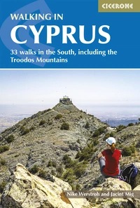
Walking in Cyprus
33 walks in the South, including the Troodos Mountains
£17.95
Guidebook to 33 walks in Cyprus. The graded routes, which range from 3 to 20km, take in the west and the Akamas Peninsula, the Troodos mountains and central Cyprus, plus various trails and coastal walks in the south and east. Includes 1:40,000 map extracts, brilliant background reading and essential practical information.
More information
What is Walking in Cyprus?
Walking in Cyprus is a collection of 33 graded day walks across southern Cyprus, exploring three very different landscapes: the rugged, mythologically charged Akamas Peninsula in the west; the pine-forested Troodos mountain range and central plateau; and the quieter trails of the south and east coasts. The walks range from gentle, flat nature trails of 3km to demanding mountain circuits of up to 20km, with routes graded 1 to 3 to suit walkers of all abilities and fitness levels.
The island's landscape is more varied than most Mediterranean destinations of comparable size. Within a single day's driving you can move from sea-level coastal paths with turquoise water and wild orchids underfoot to cool pine forest at over 1500 metres, with UNESCO-listed Byzantine churches tucked into the hillsides along the way. For walkers used to European mountain destinations, the absence of crowds on most trails is a genuine surprise: Cyprus has been a major tourist destination for decades, yet the walking trails have only recently begun to attract wider attention.
What sets this guide apart from a generic tourist description is its focus on the full range of southern Cyprus's scenery, including several trails in the central Machairas and Kionia areas that rarely appear in travel writing. The E4 European Long Distance Path, extended to Cyprus in 2005, passes through several of the walks covered here, linking Paphos and Larnaca airports via some of the island's most scenic terrain. This planning guide answers the most common questions walkers have before setting out. For complete route descriptions and 1:40,000 mapping, see the Cicerone Walking in Cyprus guidebook.
The 33 walks at a glance
The guide divides into three geographical chapters, each covering a distinct character of the island's walking landscape.
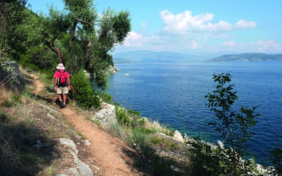
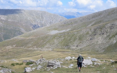
The west and the Akamas Peninsula (Walks 1–8) covers the wilder, least developed part of southern Cyprus. The Aphrodite Trail (Walk 1) and the Adonis Trail (Walk 2, 7.5km, Grade 1–2) both start from the Bath of Aphrodite on the Akamas Peninsula's northern coast. The dramatic Avakas Gorge (Walk 4, 9km, Grade 3) is one of the most spectacular gorges in the eastern Mediterranean. The Petra tou Romiou Nature Trail (Walk 5) passes near the legendary birthplace of Aphrodite. Walks in this section typically involve 1hr 30min to 3hr 30min of walking, with total ascent between 135m and 460m.
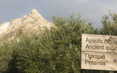
The Troodos and central Cyprus (Walks 9–27) forms the largest chapter, with nineteen routes ranging from the short Dhyo Mouttes trail (Walk 27, 4.5km, Grade 1) to the demanding Kannavia circular (Walk 20, 19km, Grade 3). Highlights include the UNESCO-linked Asinou Trail (Walk 21, 10km, Grade 2), the Panagia tou Araka route (Walk 22, 15km, Grade 2) and the Atalante Trail (Walk 14, 14km, Grade 2). Walks in this chapter involve between 150m and 960m of ascent, and some of the more serious routes (Walks 9, 19 and 20) require 5 to 6 hours.
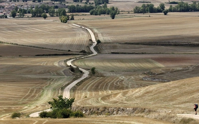
South and east (Walks 28–33) includes the scenic Pissouri coast walk (Walk 29, 8.5km or 12.5km with detour, Grade 2) and the Kavos Hill sea caves route (Walk 32, 6.5km, Grade 1) near Cape Greco.
| Route | Distance | Total ascent | Time |
|---|---|---|---|
| 1. Bath of Aphrodite (Aphrodite Trail) | 7.5km | 380m | 2hr 30min – 3hr |
| 2. Bath of Aphrodite (Adonis Trail) | 7.5km | 310m | 2hr 30min |
| 3A. Smigies picnic site | 6.5km | 180m | 2hr |
| 3B. Smigies picnic site | 3km | 140m | 1hr 15min |
| 4. Avakas Gorge | 9km (gorge: 6km) | 315m | 3hr – 3hr 30min |
| 5. Aphrodite picnic site | 6.5km | 135m | 1hr 30min – 2hr |
| 6. Locality Platanouthkia | 5km | 460m | 1hr 30min – 2hr |
| 7. Pano Panagia (Vouni path) | 8.5km (via monastery: 10.5km) | 290m | 2hr 30min – 3hr |
| 8. Trimiklini | 8.5km | 260m | 2hr 30min |
| 9. Marathasa Trail | 12.5km | 700m | 4hr 30min |
| 10. Xystarouda – Agiasma – Vasiliki | 12km | 660m | 5hr |
| 11. Prodromos Dam – Stavroulia | 9.5km | 275m | 3hr |
| 12. Kannoures Trail | 10km | 960m | 3hr – 3hr 30min |
| 13. Mnimata Piskopon | 10km | 130m | 3hr – 3hr 30min |
| 14. Atalante Trail | 14km | 325m | 4hr – 4hr 30min |
| 15. Artemis Trail | 12km (alt: 7km) | 215m | 3hr 40min |
| 16. Caledonia circular | 9km | 420m | 2hr 30min – 3hr |
| 17. Pouziaris Trail | 9km | 430m | 3hr |
| 18. Loymata ton Aeton Trail | 4km | 150m | 1hr 30min |
| 19. Madari Trail | 13km (ext: 16.5km) | 690m | 5hr |
| 20. Kannavia circular | 19km | 830km | 5hr 30min – 6hr |
| 21. Asinou Trail | 10km | 375m | 4hr |
| 22. Panagia tou Araka – Stavros tou Agiasmati | 15km | 700m | 5hr |
| 23. Politiko Nature Trail | 12km (circ: 8.5km) | 330m | 4hr |
| 24. Machairas Monastery – Fikardou | 5km (alt: 10km) | 310m | 2hr |
| 25. Kionia Nature Trail | 15km | 690m | 4hr |
| 26. Kakokefalos – Mantra tou Kampiou | 12.5km | 790m | 4hr |
| 27. Dhyo Mouttes | 4.5km | 225m | 1hr 30min |
| 28. Hapotami Trail | 9.5km | 290m | 2hr 30min – 3hr |
| 29. Pissouri coast walk | 8.5km (detour: 12.5km) | 260m | 3hr |
| 30. Kyparissia Trail | 12km | 630m | 4hr |
| 31. Stavrovouni Monastery | 5.5km | 345m | 2hr |
| 32. Kavos Hill and sea caves | 6.5km | 150m | 2hr |
| 33. Cavo Greco Visitor Centre | 6.5km | 110m | 2hr |
The hardest walk in the guide is the Kannavia circular (Walk 20, 19km, 830m ascent, 5hr 30min – 6hr), which demands a full day and good fitness. Several Troodos walks in the Grade 3 category involve navigationally complex terrain even where paths are waymarked, so experience of mountain walking is recommended for these routes.

Who is walking in Cyprus suitable for?
Cyprus has walks for almost every level of walker. Roughly a third of the 33 routes are Grade 1, meaning they are short, well-waymarked and involve modest ascent; these are genuinely accessible to beginners, families with older children, or anyone wanting a relaxed half-day outing. The Grade 2 majority of routes suit regular walkers who are comfortable with routes of 9 to 15km and several hundred metres of ascent. Grade 3 routes are for experienced walkers who are fit and comfortable with longer days and potentially rough terrain.
The island is not well suited to dog walkers on most trails, as leash regulations apply in nature reserves and some paths cross private or agricultural land. The trails are generally not pushchair-accessible. Children who are confident walkers will enjoy many of the Grade 1 and lower Grade 2 routes, particularly the coastal trails near the Akamas Peninsula and the shorter Troodos nature trails.
How difficult is walking in Cyprus?
Walkers should be aware of a few specific challenges that go beyond the grade ratings alone. Many trails in Cyprus are waymarked, but the waymarking is not unified across the island: nature trails use their own signs, the E4 has its own markers, and some village-created trails have only occasional painted arrows and cairns. Navigating from GPX files (available free for all 33 routes) is strongly recommended.
The most physically demanding sections are in the central Troodos, particularly on Walks 9, 12, 19, 20 and 25, where cumulative ascent exceeds 690m and trails can be rocky underfoot. The Avakas Gorge (Walk 4) involves scrambling in the gorge section and should not be attempted in or after heavy rain. Several Akamas walks are on exposed coastal terrain where the combination of heat and limited shade makes them more tiring than their distances suggest.

When is the best time to walk in Cyprus?
Spring (March to May) is the outstanding season for walking across the whole island. Wildflowers carpet the meadows from late February onwards, with over 30 orchid species at their best in March and April. Temperatures are warm but not prohibitive, and the Troodos paths are clear of snow. This is the best time to tackle the full range of walks in the guide.
Autumn (September to November) is the second ideal window. After the summer heat the land may be parched, but temperatures ease significantly from September and walking becomes pleasant island-wide again. The Cyprus cyclamen, the island's national flower, blooms in early autumn in moist forest areas.
Summer (May to September) brings heat that makes most coastal and low-level walks uncomfortable or potentially dangerous during the middle of the day. The Troodos mountains, which are traditionally cooler than the coast, remain walkable throughout summer, and some of the higher-altitude trails (particularly the Artemis Trail, Walk 15, and the Atalante Trail, Walk 14) can be enjoyed in the morning hours.
Winter (November to February) brings most of the island's rainfall, and snow can cover the Troodos peaks. However, the Akamas Peninsula and coastal walks in the south remain accessible, and winter walking on the coast, with its clear air and quiet paths, has its own appeal. Cyprus has Europe's most southerly ski resort on the Troodos in some winters.
What accommodation is available for walking in Cyprus?
Cyprus does not have a network of walking huts or refuges, so accommodation planning requires a different approach to, say, the Alps or the British long-distance trails. The island is well served by hotels and self-catering apartments in coastal towns including Paphos, Limassol, Larnaca and Polis, all of which make practical bases for exploring different walking areas. The Troodos has a range of options in Platres, Troodos Square and Kakopetria.
Because most walks in this guide are day walks starting and finishing at a car park or roadside, the most flexible approach is to base yourself in one or two locations and drive to walk starts. A hire car is strongly recommended for this reason; many walk starts are in remote areas with no public transport. Using a coastal town as a base and making day trips into the mountains is an entirely practical strategy given the island's compact size. A list of Cyprus Tourism Organisation licensed campsites is available at www.visitcyprus.com. For full accommodation listings, see Appendix A of the guidebook.
Getting to and around Cyprus for walking
Flights: There are direct flights to Paphos and Larnaca airports from many UK and European cities, with Easyjet, Ryanair, British Airways, Jet2 and others all operating services. Paphos airport is more convenient for the Akamas Peninsula and Troodos; Larnaca for the south and east.
Getting around: A hire car is by far the most practical option and is readily available at both airports at competitive rates. Cyprus drives on the left. Main roads are well maintained, though mountain roads can be single-lane with occasional rock fall risk. Many walk starts are in locations that buses do not reach, or are only served by one or two daily services, making independent car hire effectively essential for serious walking.
Buses: Intercity buses connect the major towns (see www.intercity-buses.com), and local services operate from Paphos, Limassol, Nicosia and Polis to some villages. Timetables require careful checking. For the Troodos mountains, taxis can be found in Platres and Troodos Square; it is worth arranging a taxi before setting out on a linear walk.
Border crossings: Several crossing points along the UN-controlled Green Line allow visitors to travel between southern Cyprus and Northern Cyprus. EU passport holders do not require a visa. Some car hire companies permit vehicles hired in the south to cross into the north, but additional insurance must be purchased.
What are the highlights of walking in Cyprus?
- Avakas Gorge (Walk 4): One of the most dramatic gorges in the eastern Mediterranean, with towering limestone walls closing to near-darkness at its narrowest. The full route is 9km, Grade 3; a shorter gorge-only version of 6km is available.
- Aphrodite and Adonis Trails (Walks 1 and 2): The most celebrated walks on the island, both starting from the Bath of Aphrodite on the Akamas Peninsula. Each covers 7.5km with outstanding coastal and scrubland scenery.
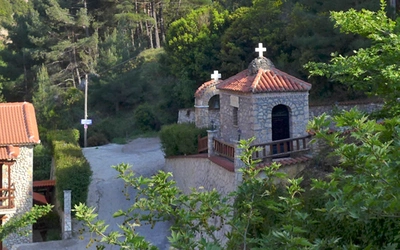
- Asinou Trail and Panagia tou Araka (Walks 21 and 22): These Troodos routes pass UNESCO World Heritage-listed Byzantine churches whose entire interiors are covered in frescos dating back to the 12th and 13th centuries.
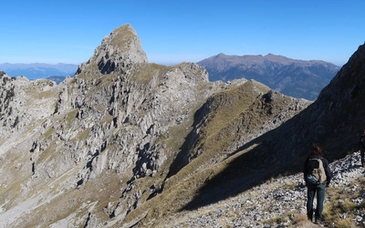
- Madari Trail and Kionia Peak (Walks 19 and 25): The highest walking in the guide, with far-reaching ridge views across the centre of the island.
- Petra tou Romiou Nature Trail (Walk 5): A coastal route near the legendary birthplace of Aphrodite, with the famous sea stack as a backdrop for much of the walk.
- Caledonia circular (Walk 16): A popular Troodos walk taking in the Caledonia waterfall, one of the few permanent waterfalls on the island.
Plan your walk with the Cicerone guidebook
The Cicerone Walking in Cyprus guidebook by Nike Werstroh and Jacint Mig contains everything you need to plan and walk all 33 routes across southern Cyprus, from the Akamas Peninsula to Cape Greco.
- 33 graded route descriptions with start/finish GPS coordinates, detailed access notes, and information on refreshments
- 1:40,000 map extracts for every walk, sufficient for navigation on the trail
- Downloadable GPX files for all 33 routes, free to registered owners
- Full background chapters on geology, plants and flowers, wildlife, brief history, and religion, alongside practical sections on getting there, getting around, accommodation, language, and tourist information
- Grade 1 to Grade 3 grading system tailored to the specific conditions of Cyprus, with honest notes on the hardest sections of each route
- Information on the E4 European Long Distance Path in Cyprus and how it connects with the walks described
- Appendices covering useful contacts and further reading
Available as a printed guidebook (£17.95) or digital eBook (£17.95).
Walking in Cyprus
33 walks in the South, including the Troodos Mountains
£17.95
Guidebook to 33 walks in Cyprus. The graded routes, which range from 3 to 20km, take in the west and the Akamas Peninsula, the Troodos mountains and central Cyprus, plus various trails and coastal walks in the south and east. Includes 1:40,000 map extracts, brilliant background reading and essential practical information.
More informationAbout Nike Werstroh and Jacint Mig, guidebook authors
Nike and Jacint met many years ago on a long coach journey as they both travelled into the unknown to build a new life in a different country. It wasn't long before they became inseparable. Travelling quickly emerged as their favourite activity and now wherever they go they try to find the best trails. They would love to share their passion for walking with others. Nike went to journalism school and Jacint is a keen photographer. Nike and Jacint live in Guildford and when they are not walking in one of their favourite mountain ranges somewhere in Europe, they enjoy exploring the diverse trails in the Surrey Hills close to their home. And when they are not out walking they offer a personalised travel planning service, details of which can be seen on Nike and Jacint's website www.trailnotes.co.uk.